Chaco Sites
Chetro Ketl
Using this Map:
Click on the map image to launch full-size, interactive map.
When you select an individual room or kiva context on the larger map, a pop-up window will appear displaying information categories from our database available for that context (Artifacts, Burials, Tree-Ring Dates, and Features).
Each of the categories can be expanded by clicking the ‘+’ to reveal an abridged list of basic information. Selecting the category heading itself will open a separate window with complete details.
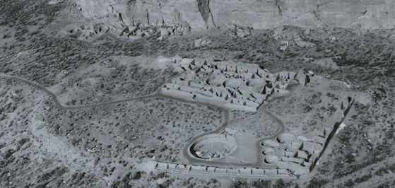
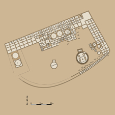
Site Description
Chetro Ketl, a classic D-shaped great house, is located 0.3 miles (0.5 km) east of Pueblo Bonito near the mouth of a small side canyon or rincon. The name “Chetro Ketl” was reported by Lieutenant Simpson in 1849, but the meaning is unclear. According to an 1849 ground plan created by Edward Kern, “Chetro Ketl” was at that time called “Pueblo Chetho Kette” which was translated as “the Rain Pueblo.”
Chetro Ketl is the second largest great house in the canyon in number of rooms (approximately 400 ground and upper-story) and the largest in surface area (more than 5.7 acres or 2.3 hectares). The great house may have risen to four stories along areas of the north side. Along the north or back wall of the pueblo, Chacoans constructed an unusual balcony. Another unusual architectural feature, a colonnade, was built along part of the plaza-facing wall in the central or northern room block, although the open spaces between the columns were later filled with masonry. Two great kivas were constructed in the large open plaza, a tower kiva (N) was erected within the central room block, and a handful of other kivas were built in both the plaza and the room blocks. The Kiva G complex was originally referred to as the “East Tower Kiva”, but, as Lekson (1983:35) points out, this is a misnomer. Kiva G is comprised of “a series of superimposed, independently constructed kivas” – Kivas G1, G2, and G3. Chetro Ketl appears to have been connected or proximate to several Chacoan roads.
Edgar Hewett began excavations of Chetro Ketl in 1920 under the sponsorship of the School of American Research and the Royal Ontario Museum. Excavations continued in 1921, ceased during Judd’s work at Pueblo Bonito, and were initiated again in the late 1920s as part of the University of New Mexico field school. Work at the site continued through 1934. Although Hewett published several short articles describing the excavations, he never completed a monograph. In addition, the surviving records are sparse. This lack of documentation has hindered Chacoan studies for decades.
The Chaco Project conducted an intensive analysis of the architecture and dendrochronology of Chetro Ketl (Lekson 1983). Construction of the great house began at about A.D. 1040 (although an earlier roomblock underlies the current pueblo) and the great house was gradually expanded and modified during several construction episodes dated to the last half of the 11th century and the first decades of the 12th century.
Alternative site designations include 29SJ1928, LA 838, and Bc 246.
Excavation History
- 1920-1921, 1929-1935: Excavated by Edgar L. Hewett and the University of New Mexico/School of American Research field schools
- 1947, 1964: Excavated by Gordon Vivian, Charles B. Voll, and Martin T. Mayer of the National Park Service
Size and Dates
- Approximately 400 ground-floor and upper-story rooms, more than 10 kivas, and two great kivas.
- Constructed between approximately A.D. 1040 and the first decades of the 12th century
