Chaco Sites
Una Vida
Site Description:
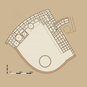
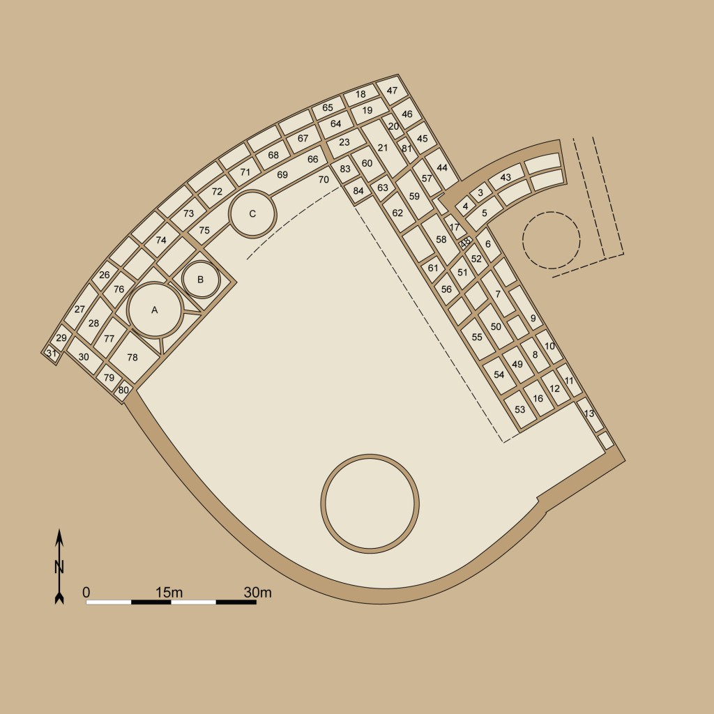
Una Vida (Spanish for “one life”) is one of the earliest great houses, along with Pueblo Bonito and Peñasco Blanco, and is the fifth largest found in the canyon with about 160 rooms, including some second-story rooms in the western and northern room blocks. The site is located in the Fajada Gap area – 3.25 miles (5.2 km.) southeast of Pueblo Bonito and 2.3 miles (3.7 km.) southeast of Hungo Pavi. Tree-ring dates from the oldest portion of the building indicate that construction was initiated in the mid-800s, about the same time as Pueblo Bonito. That effort may have been limited to the small roomblock that projects to the east of the main great house. The next building stage began in the mid-10th century and added the western roomblock within the main great house. The remaining portions of the pueblo appear to have been added between the mid-11th century and about A.D. 1100. In the historic period, hogans and a corral were constructed on the mounded ruin.
In addition to the masonry rooms, the great house includes four kivas, and either one or two great kivas. The ground plan reveals the structure has an irregular D-shaped form, which includes northern and western room blocks and a southern arc of rooms enclosing the plaza.
Una Vida may have been associated with Kin Nahasbas (an early great kiva community) located 0.2 miles (0.3 km.) north of the site. In addition, Una Vida sat at the convergence of the Chaco Wash and the Fajada Wash, a pattern of site placement common in early construction in the canyon. There is also evidence of water diversion for use at Una Vida from Gallo Canyon, about a half of a mile to the west of the site.
Gordon Vivian of the National Park Service excavated Una Vida to a limited degree in the late 1950s. The excavation uncovered information on the early stages of development at the site. The rooms were not backfilled until 1979 allowing the Chaco Project staff to gather information as well. In addition, the site was cleared and mapped in 1987 by Nancy J. Akins and William B. Gillespie of the National Park Service Chaco Project.
Alternate site designations include 29SJ391 and LA 40391.
Excavation History
- 1956, 1957, and 1960: Gordon Vivian of the National Park Service.
- 1987: Cleared and mapped by Nancy J. Akins and William B. Gillespie of the National Park Service Chaco Project.
Size and Dates
- Approximately 160, four kivas, and one or two great kivas.
- Tree-Ring Dates indicate construction between A.D. 860 and 1095.

