Previous | Table of Contents | Next
8.
An Ethnohistoric Study of Chaco Navajo Sites
Willow Roberts Powers
¶ 1 This chapter is an enquiry into the history and use of certain sites in the additions to the Chaco Culture National Historical Park through interviews of Navajos who lived in them, or who had relatives who lived there. The major period for which informants gave data on site use was 1920 to 1950; thus, the people interviewed were elderly but still active. To a very great extent, their information agrees with that given in other works on the area (Brugge 1980, 1986; Kelley 1982).
¶ 2 Ethnohistory is a method used in both anthropology and history. Originally it consisted in reconstructing the culture of, or the events relating to, groups studied by anthropologists through the analysis of documents written by outsiders, and grew to include oral traditions and interviews. Indian land claims cases, which were enabled by the Indian Claims Commission Act of 1946 and continued through the 1970s, contributed to the increased attention to and use of ethnohistory. Ethnohistory is not, however, coterminous with oral history, but as sociocultural anthropologists became more interested in learning native perspectives of their world, past and present, interviews and oral traditions took on a new role (for an excellent overview of ethnohistory and its issues, see Krech 1991). Groups in which oral tradition is the continuing means of handing down information and history have accurate memories. The use of spoken language, and the role of memory, is a conceptual toolkit often developed with specific training. Knowledge is passed down in different ways, through stories (Basso 1996), life histories and reminiscences (Griffen, 1992; Johnson 1977). This is not to say that all recollections are flawless, that strategies of omission or interpretation do not alter oral memory, or that transmission of these to an ethnographer is unproblematic. Oral history is, however, invaluable, and here its use is specific and narrow: it illuminates the family ties to and functions and reuse of Navajo sites on Chacra Mesa.
¶ 3 Before outlining the scope and methods of the study, a brief explanation is given of the way in which the work was done. Field work was undertaken by Fred York in 1985-86; the chapter itself was written by Willow Roberts Powers, drawing on York's field notes, maps and annotated survey forms. Both York's and Powers' methods are outlined below, followed by a description of the research goals. Great care was taken in the interpretation of the field notes. Because the author was not present at the interviews, any note that was unclear or appeared unfinished was either omitted or included with a notation to that effect. Ethnologists, like other researchers, carry more underlying information in their head than appears in field notes, and it is thus inevitable that much of the field data has been lost in transition. Nevertheless this chapter has attempted to be faithful to the field worker's approach, as well as to the original research goals. Where any question arose, where, for example, the author was unable to follow the direction of York's enquiries, the research goals were used as an outline into which the data were fitted. It is to be hoped that the chapter that follows presents the information as clearly as possible and that if its conclusions are not fully substantiated at least the data may be useful.
Methods
¶ 4 During the fieldwork, York visited all sites in the survey areas that had been selected for ethnohistoric study (Figure 8.1), first with archeologists who had done the survey, and then with his interpreter, who was familiar with the area and knew which families had lived at the sites. York contacted as many Navajos living in the area as possible and selected people to interview through local recommendations. Where possible, two sets of informants were taken to a site. (Usually the informants consisted of a woman and her husband; thus two sets of informants represented four people.) Some of the informants were related, but overall at least three major, separate, family groups are represented (Figures 8.2, 8.3a, b, and c, and 8.4). An interpreter from a local family was used for the interviews. He himself grew up in Chaco, and some of the informants were his relatives.
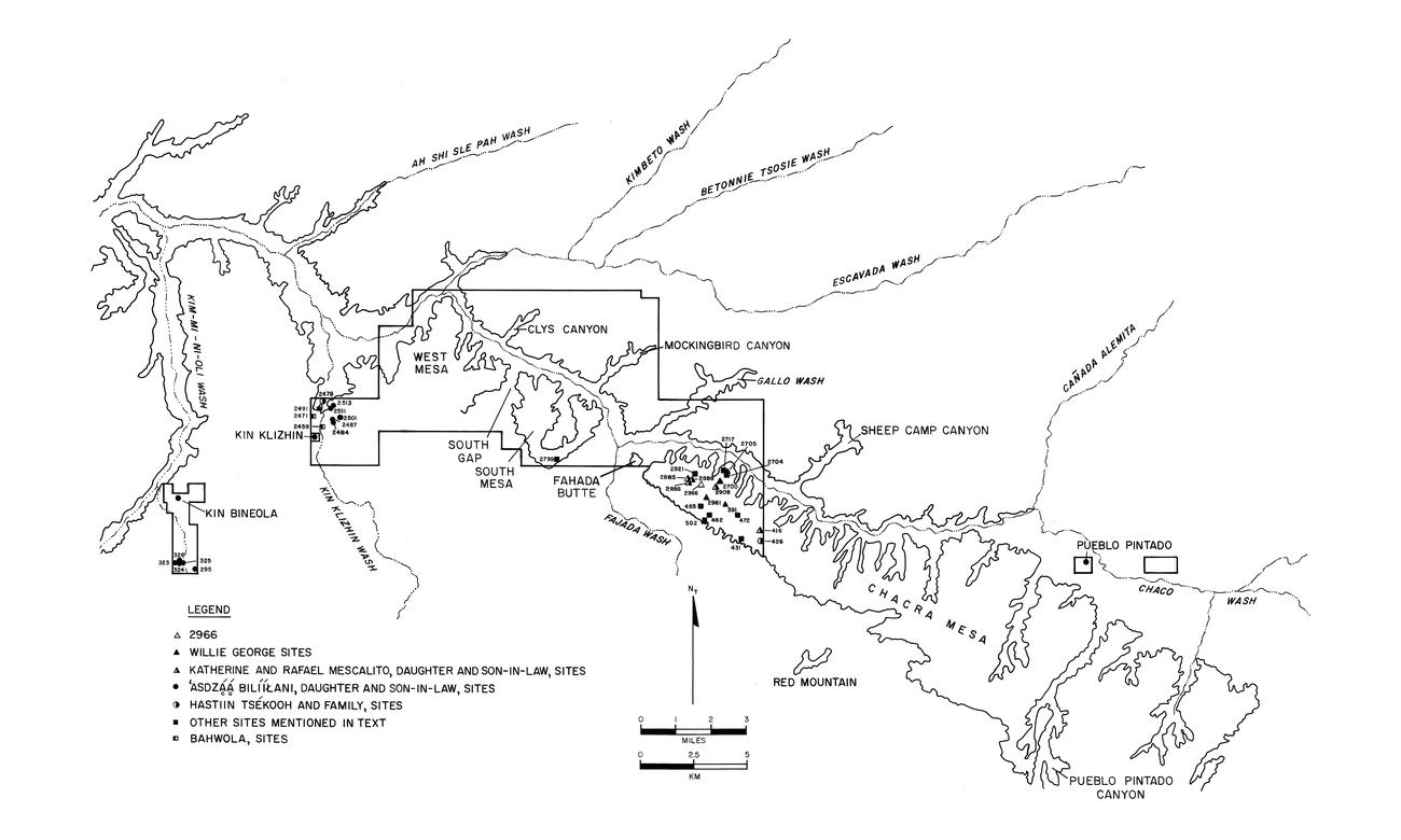 |
Figure 8.1. Map of Chaco Culture National Historical Park showing the Chaco Additions survey areas and Navajo sites discussed in the ethnohistoric study. |
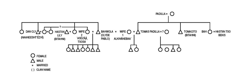 |
Figure 8.2. The Padilla family ties. |
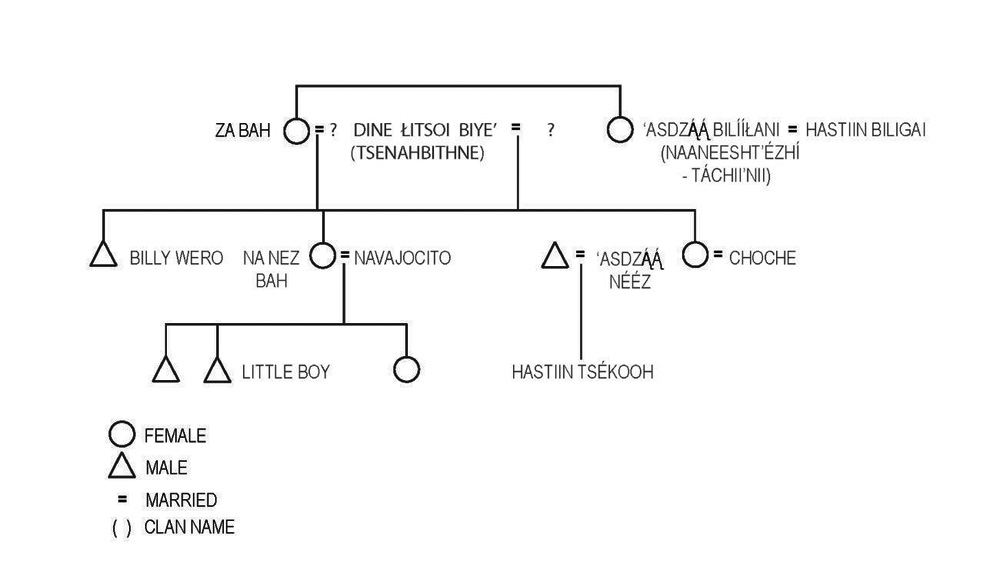 |
Figure 8.3a. Family ties for Choche through marriage. It is unclear which sister was Hastiin Tsékooh’s grandmother. |
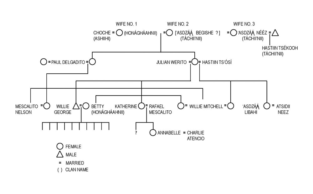 |
Figure 8.3b. Family ties for Choche. Relationships with three wives. |
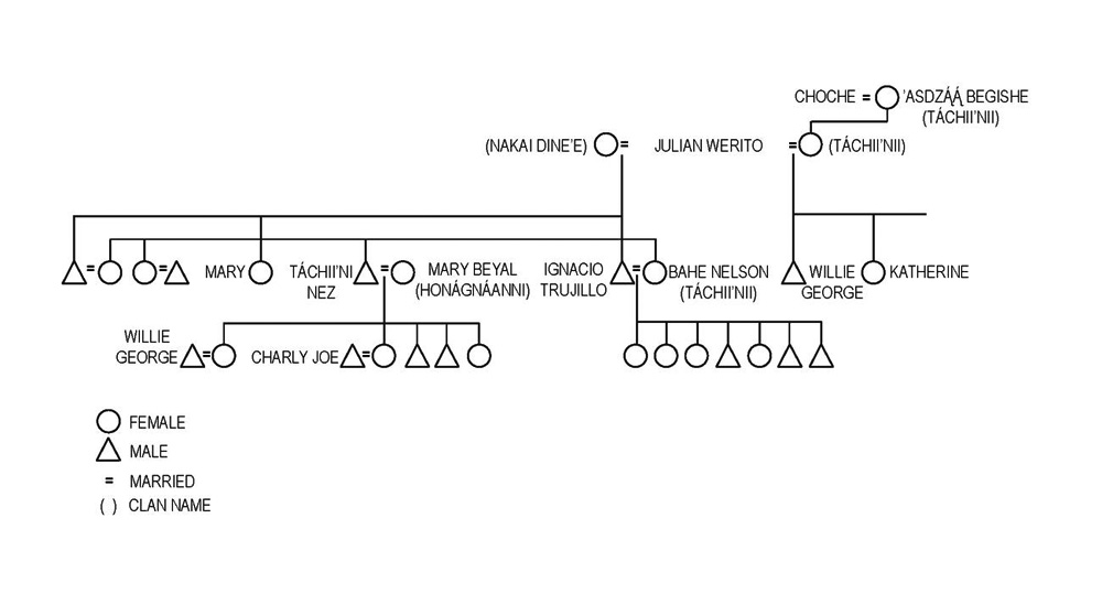 |
Figure 8.3c. Family ties for Choche. Descendants with ‘Asdzą́ą́ Begishe. |
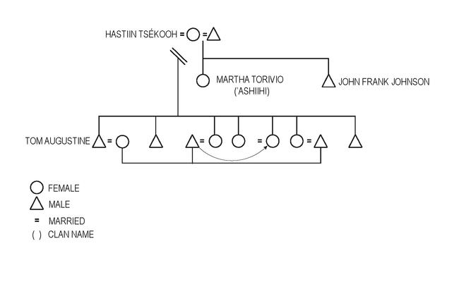 |
Figure 8.4. Relationships between Hastiin Tsékooh, his two wives, and their children. Note that his wife was married earlier; Tsékooh married her and her daughter (indicated by the slanted parallel bars) as was traditional. |
¶ 5 Inevitably, informants could not be found for all sites originally listed for inclusion in the study, and the final number of sites for which information was obtained is considerably smaller than the desired number. York also visited sites outside the study area which have not been included, except to provide general background information in the discussion. The passage of time and movement away from the study area are constraints on the choice of informants. Social relations between different families, between individuals within families, and between interpreter and informant tend to bias information. Problems also exist when informants are related to each other, or when they represent particular family groups to the exclusion of other families, some of whom may no longer live in the area.
¶ 6 In terms of this study, the results — identification of family sites, outlines of family subsistence strategies — match the original goal. The relatedness of informants does not affect the information on site attributes and seasons, nor the accuracy of the data, only its extent — there may be other families whose omission affects the overall picture.
¶ 7 The method used in writing the chapter was to compile all information into two different categories, data on sites, and data on families. This information is set out in the major portion of the chapter, the site occupation histories. The format in which it is presented follows the outline provided by the research plan under which the ethnohistory study was done, that is, discussion of data by topic, illustrated by tables. In addition there is an appendix (Appendix 8.1) which gives the informants' data for each site in the way in which the informants gave it.
Research Goals
¶ 8 The goals of the study were: 1) to evaluate and discuss Navajo and historic land ownership and use, and the effects of events, legislation, policies, Euro-American ranching or other influences in the same area; 2) to analyze site usage and settlement patterns in terms of function, seasonality, and subsistence activities such as agriculture and herding; and 3) to identify site attributes that correlate with seasonality or site type.
¶ 9 York approached these goals from the perspective of social structure, with a particular focus on family groups and the change in these groups over time. His aim was to reconstruct, as completely as possible, the individuals who occupied the sites under consideration; to reconstruct the season at which they lived at each site at different times; and to put this information in context. A major factor in York's approach was his perception that the survey areas were not in any way differentiated by Navajos, but were a natural part of a much larger region. Any study of the survey areas must therefore include information about general history, movement and change in the region of Chaco Canyon. The goal was to reconstruct family groups and to document their pattern of land use throughout an area that included but was not restricted to the survey areas. This much larger scope required more time than the project allowed.
¶ 10 However, for this author, the collected information focused around the question, “how did the family groups use their sites, and how did this use reflect events of the period?” The difference between Powers' and York's approach should be clarified to the extent that it is a difference and not simply a result of dealing with different ends of the study.
¶ 11 The research problem on which the chapter is based is this: the period for which informants gave information, 1920 to 1950, was clearly one of heavy competition between different groups all raising herds of animals in the area; it was also one of social change and economic turmoil. Furthermore, as Navajo families increased and land availability shrank, competition between Navajos must have existed in some form, in addition to heavy competition from non-Navajo ranchers. Given these events, how did Navajos adjust their subsistence strategies and land use, and what can the conjunction of site data and informant data reveal about this adjustment, in terms of site use?
¶ 12 Thus, this study uses Navajo family groups as a tool for examining competition and change. Intermarriage between families is suggested as a mechanism for cooperation and, for the marrying-in partner, a successful means of acquiring resources. York's view that the survey areas were parts of much larger areas is a shared perspective; in fact, it was this view, extended to family groups, that led to the idea that the families appearing in the study were only part of a larger community.
¶ 13 In light of this adjusted focus, the unavoidable relatedness of groups of informants assumes more significance. Information on specific families gives only part of the picture of Navajo movements, activities, and changes in the area. The information on sites clarifies and expands the knowledge of their activities and features but does not allow for comparison with or a contrast to groups of sites used by a wider range of families. Given the constraints on the selection of informants, such a comparison must always be difficult to obtain. This project has resulted in a depth of information for a small number of sites, some background history on local families, and suggestions rather than conclusions which cannot, from these data, be tested or proven.
Site Occupation Histories
¶ 14 The history of occupation of the sites which follow was given by informants who had either lived at the site at some time in their lives or whose close relatives (brother, sister, grandmother, mother's brother) had lived there. The period of interest is, obviously, as early as the informant can remember and usually falls in the years from 1920 to 1950. Dates are given as the informant gave them and are in all cases approximate; certain events render specific dates, such as the hard winter of 1931-1932, or the fencing of the Monument in 1934 and 1949. The data are given by topics, and each topic has a table in which all sites under discussion are shown for comparison.
Site Location Choice
¶ 15 There is no information in the field notes regarding the reasons a Navajo family chose any of the survey sites, and no discussion of whether a particular site was better than, or not so good as, any other site. However, site location by seasonality is very specifically given by almost all the informants (Table 8.1a, b): canyons were used in summer, and mesa tops in winter. This reflected, at least partly, the availability of water. In addition, certain areas were preferred by the families interviewed for each season: the area north of the Escavada Wash for summer residences, Chaco Canyon and the area around Pueblo Pintado (in other words the entire length of Chacra Mesa) for winter residences. Summer residences were called Shiih, winter residences Hai.
Table 8.1a. Function and dates of sites according to informants.
Table 8.1b. Function and dates of sites compared with other data (Navajo use only).
¶ 16 There are a couple of points that should be made about the lack of information in the notes regarding site location. First of all, most of the sites were not chosen by the informants but by their parents or grand-parents, usually before the informants were born. Indeed, family use rights are, it appears, part of the pattern of site use. Two or three generations may use a site without having a role in its initial selection. However, because most nuclear families had a choice of ready-made (family) sites and because they frequently set up new ones, there is clearly a decision involved.
Use of Manufactured Goods
¶ 17 No information was gathered about the use of manufactured goods on any site, with the exception of tents (see section entitled Activities on Sites). However, some of the general interviews contained details of goods obtained from trading posts, and these are given below.
¶ 18
- Wagons — used for traveling between residences, for hauling water, for trips to a trading post. Purchased from trading post.
- Stoves — usually 50 gallon barrels cut in half. Sometimes these were obtained (whether purchased or not is unclear) from the trading post; sometimes, in the winter, Sargent's Spanish herders would trade barrels for Navajo jewelry or turquoise. Informants noted that stove pipes were made from cans, with both ends cut out, and then wired together.
- Axes — sharpened on cliff faces. Used for cutting wood (probably metal; none found on survey).
- Hand Shears — for shearing sheep. (One informant notes that Sargent's Spanish herders had electric shears, apparently in the mid-1950s.)
- Saddles, Harnesses — purchased from trader.
¶ 19 For information on manufactured goods found as artifacts on sites, see Powers and Warburton (Chapter 7).
Function and Dates of Sites
Chacra Mesa
¶ 20 Chacra Mesa was used as a winter grazing area (Table 8.1a, b, Figure 8.1). Dates reflect what the informants remember, and are in all cases approximate, although the “Big Snow winter” (the winter of 1931-1932) is a useful marker, as is the fencing of various areas. The function of most of the sites was winter residence for families with herds of sheep, goats and horses. A few sites have other functions: 29Mc 431, 29Mc 465, and 29Mc 502 are trail sites; and it is unclear what, if any, other functions they served. 29Mc 462 and 29Mc 502 have play hogans, also without clear indication of residential or herding features. 29Mc 2981 was said by one informant to be maybe the site of a squaw dance; these are usually held in summer, but this one was apparently held early in March.
¶ 21 It is worth noting that site 29SJ 2888 is a sweat lodge site, which informants said was used by the men who lived at 29SJ 2966. The women's sweat lodge was at site 29SJ 2886. (29SJ 2888 has no other site features 29SJ 2886 has some evidence of other structures, possibly not contemporary and not commented on by the informant. At the time of use, each sweat lodge site was a distinct, uni-functional area, related to 29SJ 2966.) Several related families, and three generations, lived together at 29SJ 2966, perhaps explaining the need for two different sweat lodges. Both 29SJ 2888 and 29SJ 2886 are some distance to the northwest of 29SJ 2966.
¶ 22 Sites vary in length of use, some being used only for one winter, others for many years (it would be interesting to know what the relationship was between reasons for choosing a site and length of use). 29SJ 2966, for example, was used in winter from at least the early 1930s and most likely the 1920s to the early 1950s. 29SJ 2700 was used for three years by one Navajo family (and following fencing in the area, by Spanish herders). 29Mc 391 was only used for one winter.
Kin Klizhin
¶ 23 This area was used, apparently, in the spring and summer by Navajos, and in winter by the Spanish herders who came later (as indicated by the dates of several inscriptions on the rocks). The sites are all located at the edges of a broad valley whose wash is dry except after rain. Rock outcrops at the valley edge near some sites create natural walls to build pens against; at other sites, dry stone walls have been built for corrals.
¶ 24 Informants mention fields in the area, although none appeared to be on or adjacent to any of the sites examined. Clyde Pablo farmed here (see endnote 7, Chapter 6), and in the spring he moved to Lake Valley to plant crops for the summer. One of the major users of this and the Kin Bineola area, ‘Asdzą́ą́ Bilííłáni — her name means Mrs. Many Horses — had large herds of cattle, horses, and sheep. Her grandson estimated their size as approximately 2,000 sheep, 100 cattle (later on, 1,000 cattle), many horses, for the period around the 1920s. Her grandson, who was probably born in the early 1900s, remembers herding for her.
¶ 25 Kin Klizhin is undoubtedly part of a much larger area used by the families mentioned as occupying sites here. Unfortunately there is much less information for this area. One informant mentioned that some of the earlier families wintered to the north of Kin Bineola (presumably Lake Valley).
Kin Bineola
¶ 26 There is less information for Kin Bineola. Information on three sites occupied in the early 20th century reveals that two of them were used in spring (Table 8.1a, b). Littleboy and his family used this area, as well as the Kin Klizhin area; an area to the northwest (probably Lake Valley) was used in winter by several families.
Navajo Occupants of Sites
Chacra Mesa
¶ 27 Data on the site occupants give a very clear picture of sites being used, both simultaneously and through time, by related families (Table 8.2). This is hardly surprising or a new fact. Sites on Chacra Mesa, in particular, have considerable informant data on who lived at which sites, whom they shared sites with, and how they were related (Table 8.3).
Table 8.2. Navajo occupants of sites.
Table 8.3. Kin and clan ties of occupants.
¶ 28 The descendants of Choche, who is also referred to as Navajo George (Choche is the Navajo pronunciation, also given as Gushi and Guehi, of his Anglo name, George), used Chacra Mesa for winter grazing. Almost all the names mentioned in Table 8.2 are related to him, and those not related to him are related by marriage to his grandchildren. (For greater detail on the kin and clan ties of site occupants, see Table 8.3) Charlie Joe's wife and Willie George's wife were sisters; ‘Asdzą́ą́ Begishe was one of Choche's wives.
¶ 29 However, the relatedness of these occupants may be, in part, a result of the fact that all the informants for Chacra Mesa sites were related to Choche's descendants either by blood or marriage. It is worth noting that Asdzą́ą́ Nééz - Tall Woman - (site 29Mc 426) may be either Hastiin Tsékooh's wife or his mother (who was later also a wife of Choche) (Figure 8.3a, b). The name is a fairly common one, and both women may have been known as Asdzą́ą́ Nééz at some point in their lives (for a useful discussion of Navajo names, see Young 1961:539-40). The site is on the part of Chacra Mesa used by Tsékooh in the 1930s (see Kelley 1982:209). Hastiin Tsékooh, his wife or wives, and children (Figure 8.4) lived at the foot of Chacra Mesa (outside the area of this study) and were eventually moved out of it by Edward Sargent, an Anglo who came into the Chaco area in 1899 and became one of the larger sheep ranchers there. He owned the Chaco trading post by 1917, and by 1920 ran 60,000 head of sheep in and around Chaco (see Brugge 1980, Kelley 1982, for details on Sargent). The family moved east, still at the edge of Chacra Mesa, and continued to use the public lands on Chacra Mesa. Later, according to his grandson, these lands were exchanged for land on the Escavada and around Pueblo Pintado, and his descendants still live in both places.
¶ 30 Very few allotments were made on the northwestern end (the section bordering Chaco Canyon) of Chacra Mesa. However, Choche had an allotment in Section 26, T21N R10W (Brugge 1974) at the foot of Chacra Mesa. Willie George, Choche's grandson, had an allotment on the mesa top, Section 34, T21 R10W (Brugge 1974). The northwestern tip of Chacra Mesa was used by Choche from at least 1907 and by his descendants up to at least 1950 (Kelley 1982:200, 228).
¶ 31 It is worth noting that informants did not often go back very far in their history of the site, yet some sites are mentioned as probably having been used by a grandparent. This suggests that sites were not used for several generations, but rather were lived in for a several seasons, and possibly reused later on for a slightly different function.
Kin Klizhin and Kin Bineola
¶ 32 In the Kin Klizhin area, three names of people appear on one or more sites, at least two of whom seemed to have been prominent in their time. ‘Asdzą́ą́ Bilííłáni was rich in herds (see above), and she is the occupant of many sites in this area, as well as in Kin Bineola. Hastiin Tsékooh, grandson of either ‘Asdzą́ą́ Bilííłáni or of her sister Za Bah, also used the area to the south and in winter, to the northwest of Kin Bineola. He also used the Seven Lakes area, where he got an allotment, and later on he moved to Chaco Canyon, Chacra Mesa, and, finally, Escavada. Clyde Pablo, also known as Bahwola, was the son of a singer, and appears to have farmed as well as herded. His Kin Klizhin site, 29SJ 2459, has an interesting rectangular structure, built by him (see Corbett 1938), as well as a hogan that was apparently used solely for ceremonies. Two of his daughters herded for him when he went to Lake Valley to plant.
Kin and Clan Ties of Occupants
Chacra Mesa
¶ 33 The three sites listed below are the only sites for which there is any data for shared usage and sequential usage. It is evident that families who share the same site were closely related (Table 8.3, Figure 8.3a). Each nuclear family lived in a separate hogan. At 29SJ 2966, almost all of the occupants mentioned by informants are known to be related to Choche or to his grandchildren. At least two of the families who kept returning to the site, Choche's granddaughter (Katherine Mescalito) and her husband (Rafael Mescalito), and their daughter and her husband, built new hogans for themselves on several occasions. Information on 29SJ 2966 for the period of the 1940s is less specific. Tissie Yazzie (Table 8.3) may be related to Willie George. Informants did not mention, either when interviewed on the site or at any later date, the family ties of John Padilla or Francis Norberto, but the latter is married to a daughter of Hastiin Tsékooh (an in-law of Choche’s). Tissie Yazzie and his wife and son are mentioned frequently in different contexts with clan affiliation; it appears they shared a hogan with Katherine Mescalito's daughter and son-in-law, Annabelle and Charlie Atencio, when they first came to 29SJ 2966. It seems highly likely that they are related; Charlie is ‘Ashiihi clan and so is Tissie Yazzie. John Padilla is not mentioned in any other interviews.
¶ 34 Furthermore, it seems possible that part of the reason behind this doubling up in sites is the competition for land that occurred, particularly in the 1930s. The trend towards wage work to supplement animal husbandry may have had an influence, particularly since the National Park Service was a constant source of work.
¶ 35 Most of the sites for Chacra Mesa listed in Table 8.2 are occupied by people known to be related to Choche or his descendants with the exception of the people mentioned above, ‘Asdzą́ą́ Bighan Nteeli (whose kin ties are unknown), and ‘Asdzą́ą́ Nééz, who may be Choche's wife.
¶ 36 Nuclear families built a site, spent anywhere from one to three years in it, then moved to another or a new site for a time. With large herds, movement from site to site in the same winter occurred, with one site remaining as a base. In this regard, it is interesting to note that an informant on 29SJ 2908, for example, mentions leaving stores of flour and potatoes in the hogan, with a padlock on the door. This flexibility of site usage seems to have been the norm. This practice would suggest that the high number of sites on Chacra Mesa may not indicate large numbers of people.
Kin Klizhin and Kin Bineola
¶ 37 Two sites at Kin Klizhin were occupied by Bahwola (Clyde Pablo) and his sister; all the other sites here and at Kin Bineola appear to be occupied at one time or another by ‘Asdzą́ą́ Bilííłáni, her daughters and grandchildren.
Navajo Activities on Sites
Chacra Mesa, South Addition, Kin Klizhin, and Kin Bineola
¶ 38 Given the 50-year time span, it was inevitable that informants did not remember all the day-to-day details of their activities on sites where they lived in the past (Table 8.4). The details that they do remember tend to relate to the structures still visible on sites, such as lamb pens or corrals, and events that stand out in their memory, such as the burning of a hogan or a ceremonial. Details given in the above table are those specifically mentioned by informants; other activities may have occurred here, either forgotten or when other occupants were at the site. Of interest are those activities which clarify or add information to the site survey.
Table 8.4. Navajo activities on sites.
¶ 39 On two sites, 29SJ 2700 and 29SJ 2966 on Chacra Mesa, informants identified small rock piles as former chicken houses and other small structures as dog houses. Both sites were occupied by the same Navajo family.
¶ 40 On several sites, certain structures were identified as play houses by informants whose own children had built them: 29Mc 431, 29Mc 465, 29Mc 502, on Chacra Mesa, and 29Mc 2484 at Kin Klizhin. Again, the absence of such identification on other sites is not an indication that such structures did not exist, merely that the informants did not know it.
¶ 41 Informants usually remembered what animals were kept in which corrals, but without indicating (at least in the field notes) whether they based this on memory or on some characteristic of the structure itself. Lamb pens, however, would seem to be differentiated from other pens by size, the shelter given by the location, and sometimes by indications of a rough roofing to protect the lambs from coyotes.
¶ 42 Certain sites were specifically mentioned by informants as not having been residential; in some cases, however, it may be that in identifying a particular corral, and remembering who used it, informants recalled that that owner did not reside at that site. For example, 29SJ 2886 had a hogan on it, which was said to have been occupied in the 1920s; later on a sweat lodge was built there, and it was used solely for sweat baths for women living at 29SJ 2966. Certain sites such as 29SJ 2704 on Chacra Mesa and 29SJ 2484 at Kin Klizhin were given tentative residential status because informants could not remember with certainty who lived there. Hogans at these sites indicate that they were residential. For 29SJ 2491, at Kin Klizhin, the informants recalled only that Spanish herders used the area and did not remember that any Navajo they knew had lived at or used the site.
Trails, Wagon Roads and Water Sources
Chacra Mesa, Kin Klizhin and Kin Bineola
¶ 43 Chacra Mesa was used in winter, and snow, when it fell, was one source of water, melted and used for both sheep and people. Holes in the rock (it was not made clear if these holes were natural or man-made or both) were also used as water collection basins (Table 8.5). In addition, there were springs and seeps at the heads of many of the small canyons which branch out of Chacra Mesa.
Table 8.5. Trails, wagon roads, and water sources.
¶ 44 Most of the sites seem to have had more than one possible source of water. The cluster of sites 29SJ 2885, 29SJ 2886, 29SJ 2888 and 29SJ 2921 were between Bird Spring (Tsídiito'í) in the canyon to the west and Bitter Water Spring (Tódík'óózhi) in the canyon to the east; 29SJ 2955 and 29SJ 2966 were between Bitter Water Spring to the east and Bobcat Spring (Náshdóí Bitó) to the west. 29SJ 2700, 29SJ 2704, 29SJ 2705, 29SJ 2717, 29SJ 2721 and 29SJ 2908 are to the east of Bobcat Spring. The water source for 29SJ 2908 is given as Tóhááłí, with no location, and a pool in a canyon to the north; presumably the rest of the sites in this cluster were also close to these sources. Whether there were use rights to different springs and pools, or whether ease of access decided who used which source, is not mentioned by informants. Of interest, however, is the fact that informants mentioned use of wagons for hauling water. Such transportation meant some flexibility for choosing sites in relation to water.
¶ 45 Information on water sources and trading posts is very limited for the Kin Klizhin and Kin Bineola areas, in part because the informants were very elderly and did not remember. At least two sites, 29SJ 2491 and 29SJ 2501 at Kin Klizhin, brought water from a distance, presumably by wagon; Kin Bineola sites have a lake (Juan’s Lake) not far away. These are areas used primarily in spring and summer, and water would obviously have been a crucial resource.
¶ 46 Trading post use varied with season and with the changes in trading post locations. According to one informant, a visit would be made to the trading post before moving to winter camps. The trading posts most mentioned by those who spent the winter on Chacra Mesa were Chaco Canyon Trading Post, at Pueblo del Arroyo, and Kimbeto Trading Post to the north above Escavada Wash; there was also some suggestion that there was a trading post on or near Sargent's ranch, in a building that Navajo George (Choche) later used. For Kin Bineola, one informant mentioned trading posts at Chaco Canyon, Tsaya Tó (Tsaya Trading Post is by a spring), and Lake Valley.
Departure and Later Spanish Use
Chacra Mesa
¶ 47 Navajos of this area had been competing with ranchers since before the turn of the century. The National Park Service was also a competitor of a kind, because it removed lands in the Monument from Navajo usage. One informant mentioned a National Park Service fence in the 1930s, either on the mesa itself, or in some other location that impeded the movement of herds. Fencing of the Monument was begun in 1934. Informants mentioned the 1934 fencing both because they or their relatives worked on it and because it affected movement of their herds. Willie George moved out of 29SJ 2966 because of fences. However, some of these might have been Sargent's fences, because the eastern end of the Monument was only fenced in 1947 (Brugge 1980:485). Later fencing in 1947 and 1949 is also mentioned by informants. Sargent had fenced the boundary of the Chaco Canyon ranch earlier, but acquired Hastiin Tsékooh's land on Chacra Mesa in 1948 (Kelley 1982:143) and may have fenced it then. The northwestern end of Chacra Mesa seems to have been used by Navajos into the early 1950s, although their herds became smaller and smaller. By the late 1940s, Sargent himself was reducing his cattle and sheep operation. He sold his ranch to the Navajo Tribe just before his death in 1958.
¶ 48 Spanish inscriptions add another detail to non-Navajo use of the mesa (Table 8.6). Of the total number of inscriptions found (n=42; this includes some inscriptions that were outside the 1983-84 survey area), 24 percent (n=10) date to the period between 1900 and 19281In fact, there are no inscriptions on Chacra Mesa between 1920-1928., and the remaining 76 percent (n=32) date between 1929 and 1947. Increased literacy may be a factor but probably does not account for the entire increase. In contrast, for the rest of the Chaco Canyon area (not including the Kin Klizhin/Kin Bineola area), the shift is in the other direction: of all recorded inscriptions (n=90), 72 percent (n=65) fall in the period 1900-1928 and the remaining 28 percent (n=25) in the period 1929-1947. Here, of course, the boundary fence had an effect.
Table 8.6. Abandonment and later Spanish use of Navajo sites (includes sites not visited by informants).
Kin Klizhin and Kin Bineola
¶ 49 Both the Kin Klizhin and Kin Bineola areas were used by Spanish herders working for big Anglo ranchers (Table 8.6). One informant described how she and her sister herded sheep near 29SJ 2459 at Kin Klizhin when their parents went to Lake Valley to plant crops, and mentioned that “cowboys” used to chase them.
¶ 50 Spanish inscriptions at Navajo sites in the survey areas are shown in Table 8.6; an inscription by inscription breakdown is given in Appendix 6.1, Table 9.
Discussion
History of Land Use Patterns
¶ 51 There is an excellent and detailed account of land use patterns in the larger area of which Chaco Canyon is a part, with specific attention to ranching in Chaco Canyon, in Klara Kelley's The Chaco Canyon Ranch (1982). The account given here is considerably briefer and less detailed; rather it attempts to sketch the broad picture of land use and land competition.
¶ 52 Navajos, an Athabaskan group related to Apaches, have lived in Chaco Canyon since the beginning of the 18th century (Bailey and Bailey 1986; Brugge 1986). Brugge (1986) states that Chacra Mesa was inhabited by Navajos by 1730. Three Navajo sites described in this volume (Table 4.13; see Chapter 6 also) had historic Pueblo ceramics made in the 17th and early 18th centuries, indicating possible occupation prior to 1750. Late in the 18th century, hostility between Navajos and Spanish over land kept up a continual state of war and skirmish in the area, a situation which did not abate after the acquisition of New Mexico by the United States in 1846. Raiding continued, and in 1864 Navajos from the west and from the Chaco area were taken down to Fort Sumner, where they were incarcerated for four years, in an attempt to turn them into farmers. The effort did not meet with success, and they were released in 1868, on the understanding that they would go back to their lands, now set aside for them, largely in Arizona and New Mexico. Navajos who came from Chaco, which had not been included in the reservation, returned to their old homes.
¶ 53 Hispanic and Anglo settlers were moving into this area, in particular ranchers who saw the great tracts of unsettled land as ideal for herds. In the 1870s there were two outfits running cattle in the area: the LC outfit whose headquarters stood to the northwest of the ruin of Peñasco Blanco; and the Carlisle Cattle Company on Gallegos Wash some distance north, who wintered cattle in and near Chaco Canyon. These outfits were no longer operating in 1898, when Richard Wetherill moved into the Canyon. In addition to excavating the ruins and encouraging others to excavate, Wetherill ran a trading post, and a sheep herding operation which was enlarged to include horses and cattle. The AT & SF railroad moved steadily west in the 1880s, providing incentive for cattle ranching. Spanish herders were being pushed off their ancient land grants, and they too came into the checkerboard region.
¶ 54 By the turn of the century, land in this checkerboard region was a patchwork of public lands, railroad grants, and land claimed by homesteaders and ranchers; there was hot competition between Navajos, ranchers, herders on public lands, and homesteaders. In 1905 the Commissioner of Indian Affairs recommended that the Navajo reservation be extended to the east to cover this area of New Mexico. However, because of the political strength of Anglo ranchers, the land was only withdrawn from homesteading in order to allow Navajos to file for allotments in accordance with the Indian Allotment Act of 1887; whatever land remained after allotments had been completed would then be returned to the public domain.
¶ 55 The federal government, through the Navajo Agency (as this branch of the Bureau of Indian Affairs [BIA] was then called) had already begun to allot land to local Indians and help them obtain leases on railroad lands. This was not a popular move with sheep ranchers, who used the claim that Navajo sheep had scabies, a contagious parasitic disease, as another weapon in the struggle for land. Ranchers dipped their own animals. Although there was some evidence that Navajo sheep, a small tough breed known as churros, were resistant to scabies, eventually the Navajo Agent began a dipping program for Navajo herds. The Navajo Agency set up an agency for the area to assist in allotments and leasing for the eastern Navajos, and to build a school. In 1909 S.F. Stacher was appointed Agent and established headquarters for the time being at Pueblo Bonito (he later moved the agency to Crownpoint).
¶ 56 Chaco Canyon had been made a national monument in 1907, although at this date the official designation made little difference to the Navajos. However, it brought the federal government into the picture, in effect, as another factor in the general competition for land. Eventually Navajos who lived and ran herds in the canyon were moved out, and fences were put up.
¶ 57 Commercial ranching in the canyon and the immediate vicinity continued. Richard Wetherill's operation ended in 1910, when he was shot and killed. Ed Sargent had been wintering sheep in the region since the turn of the century, and after Wetherill's death he came down to look over his holdings (Brugge 1980). By 1912 he owned the Chaco Canyon Ranch (also referred to as the Sargent Ranch), which lay immediately to the east of the Monument boundary, beyond Wijiji ruin, and included part of Chacra Mesa. He and the Spanish herders who worked for him on the partido system used the land to the north and east also. At this period, sheep were wintered in Chaco Canyon and taken up to Chama, where Sargent also had a ranch, for the summer. In 1918 Sargent leased the Pueblo Bonito Trading Post. I. K. Westbrook moved into the Kin Klizhin/Kin Bineola area, leasing land from Sargent (Kelley 1982:118-119).
¶ 58 During this period, a Navajo entrepreneur called Navajo George (referred to by informants in this Chapter as Choche) was also running large sheep herds in the Chaco Canyon region (Kelley 1982:195) and had apparently been a local rico since the 1890s, if not earlier (Brugge 1980:129). George or Choche hired both Navajo and Spanish herders; his sheep were wintered on Chacra Mesa and in summer grazed the plains to the south of the mesa, between Fajada Butte and Red Mountain, as well as areas on Escavada Wash to the north (Kelley 1982:200). By 1908 he owned an allotment; he also leased land from the railroads. He was not the only Navajo who ran large herds in this area at this time; Hastiin Ts'ósí and his son and son-in-law, Paul Delgadito and Atsidii Nééz respectively, were also big league herders (Kelley 1982:196-204).
¶ 59 The extent of their herds is hard to estimate. Kelley quotes figures from different sources that estimate Ts'ósí's herds as ranging from 2,000 sheep to 5,000 sheep and goats, and cattle in addition; and she suggests that Choche had similarly sized herds. Other Navajos had respectable numbers of animals, even though their herds were not comparable to these entrepreneurs. Hastiin Tsékooh and Diné Łitsoi are both mentioned by Kelley as having possibly 200 to 300 head of sheep each, and may have had more (see below). Altogether, Kelley estimates that Navajo families in the general area of Chaco Canyon were running between 4,200 and 10,300 sheep (Kelley 1982:197). If, as seems highly feasible, the larger number is taken, and if one takes into account the Spanish partido herders, the area was neither empty nor undergrazed and competition was at a peak. Choche died around 1915 (Kelley 1982:204) and Hastiin Ts'ósí in 1918 (Kelley 1982:205), the latter from poisoned liquor. Their descendants inherited the sheep and kept the herds on a land base that, unlike the animals, did not increase.
¶ 60 Competition from ranchers was not the only problem Navajos faced; the environment, natural and social, provided others. Drought and water sources were continual problems; there was a flu epidemic in 1918 in which many Navajos died; bad winters and late springs made both lambing and agriculture precarious. Economic depression affected the Navajos, who now relied on the trading post for a wide variety of tools, cooking utensils, harness, and food. These goods were mainly obtained in a barter system by which traders purchased Navajo wool at market rates, giving out supplies from the store at an equivalent dollar amount. In addition, Navajos were hired by the railroad companies, occasionally by traders and ranchers, and for the archeological excavation under Neil Judd that began at Pueblo Bonito in 1921. Somewhat later, in the 1930s, the National Park Service also employed Navajos to put up fences and restore the ruins. The economic depression of 1929 affected the market for wool and lambs. As a final straw, the winter of 1931-1932 was a fierce one (remembered by informants in this history as the Big Snow Winter, it provides an indelible reference point by which to date events). Throughout the winter, roads and trails were blocked by the storms, and Agent Stacher dispatched feed for Navajo herds. Losses in both Anglo and Navajo herds were high, but Brugge, quoting Navajo losses of 50 percent, suggests that the winter resulted in a general Navajo setback (Brugge 1980:389).
¶ 61 The election of Franklin D. Roosevelt, the inception of the New Deal, and the appointment of John Collier as Commissioner of Indian Affairs followed hard on the heels of the Big Snow Winter. The wages that came to the Navajo under Government work programs were insufficient to bolster the loss of sheep, the lower prices of wool, and lambs. When the stock reduction program to alleviate the problem of overgrazing was begun by Collier in 1933, Navajos were, understandably, anything but willing to give up any members of their diminishing flocks even though, under the plan, those who chose to sell sheep would be reimbursed by the Government. Resistance, although not as dramatic in the Chaco region as on the reservation proper, grew by degrees as the program proceeded. In general, the small herder was hurt far more than those with large herds (Brugge 1980). The National Park Service provided mixed blessings to the Navajos. In 1934 the National Park Service began to fence the Monument, in the continuing attempt to keep out all herds. This created problems for Navajos who, having already moved out of their homes in the canyon, still drove herds through it from their summer grazing areas above the Escavada Wash to winter pastures south and west of the canyon. However, local Navajos were employed by the National Park Service, for the most part to work on the ruins (Brugge 1980:426). The restrictions on herds within the Monument were applied far more successfully to the Navajos than to Ed Sargent, whose ranch was on the eastern boundary. Allotments which had been made earlier to Navajos on land inside the boundary were being canceled by the BIA and exchanged for allotments elsewhere. But relations with the National Park Service and its individual employees seem to have been generally good. Small favors were often performed for Navajos, such as taking care of burials, and ruins stabilization provided work for the Navajo men from the 1930s to the present (Brugge 1980:440-443).
¶ 62 In 1942, after the United States formally entered World War II, many Navajos signed up for military service. The Government, directing its energies towards the war, ceased its efforts to reduce Navajo herds. The last fence was put up at the east end of the Monument after Sargent's lease of former railroad lands ran out in 1946 (Brugge 1980). The post-war years brought different problems and different strategies. Oil exploration in the checkerboard region intensified in the 1950s. Drilling and discovery that took place on Navajo allotments paid royalties to individual Navajos; this was a contrast to the Navajo Reservation, where royalties from any mining or drilling went to the Navajo Tribe. And, in 1958, Ed Sargent's ranch was sold to the Tribe, a small irony in the competition for land: at a time when, as a result of political growth and change, the Navajos as a political entity successfully gained land, most of the local families no longer relied on large herds of sheep for subsistence.
The Ethnohistoric Account: ca. 1920-1950
¶ 63 The years covered most extensively by informants were those of the 1930s. Information of a general kind goes back earlier, but because most of the informants were born between 1901 and 1925, it is not direct knowledge. However, while childhood memories may be unreliable at times, many of the details concern family members and would undoubtedly be learned as adults, and are worth passing on for the general picture.
¶ 64 There are two points made in the introductory remarks which should be reiterated here because they relate specifically to the data to be presented. First, the sites, and the areas within which the sites are located — Chacra Mesa, Kin Klizhin, Kin Bineola (Figure 8.1) — are only small sections of larger regions, and Navajo use does not treat these areas as distinct from the larger regions. Thus, great care must be taken not to distort the whole picture as a result of making these areas the focus of research. Second, informants are related to each other, tending to give a clear pattern for their own extended family but not of others. In addition, most of the informants are descendants of well-known, well-to-do Navajo families. This too gives an incomplete account. The effects of events on smaller families or families with smaller herds is also important for the record. However, these are the constraints of ethnological fieldwork; with this caveat, the informants' accounts of their families’ movements and activities are given below. Comments in brackets are added by the author; paragraphs under the heading (I) contain informant data, those marked (ii) give information from other sources.
Agapito Atencio
¶ 65 (i) Agapito Atencio, or Hastiin Cotton, or “Algodon,” was a medicine man [probably born in the late nineteenth century]. He was married to a daughter of Hastiin Tóbahkini and lived in Mockingbird Canyon; his grandson (the informant) was born there in 1923. Another grandson was buried on the west side of Mockingbird, and two granddaughters were buried in the Pueblo Bonito cemetery. In those days Navajos used to live in the Canyon [probably Chaco Canyon is meant] winter and summer. People still lived in the Canyon after the fence until Superintendent McNeel [sic]. Gordon Vivian made an agreement; planned to have a hogan built — NPS workers built it in one day — and the family moved to the hogan with an agreement to get jobs. [This probably meant jobs with the National Park Service.]
¶ 66 (ii) Agapito Atencio worked for Wetherill at Pueblo Bonito in 1895 and, at that time, had a home on the Escavada Wash (Brugge 1980:155,158). Atencio, his son and grandson all worked for the National Park Service, and Atencio was still working for them in 1942 (Brugge 1980:463). His grandson Charley married a great-granddaughter (Annabelle) of Choche and spent winters with her family on Chacra Mesa at 29SJ 2966 from 1945 until the early 1950s.
Bahwola, or Clyde Pablo
¶ 67 (i) Bahwola was a brother of Dan Cly [b.1895], a singer who lived in Chaco Canyon; they were of the Naaneesht'ézhí clan. Bahwola lived in the Kin Klizhin/Kin Bineola area, year round, and used land to the west and other places. He had fields in Kin Bineola but did not have a place there. His son still farmed in the Kin Bineola area in the 1980s. He had many sheep and very many horses, but no cattle. Bahwola probably worked on the railroad and also worked for ranchers, in particular I. K. Westbrook; he moved to Kin Klizhin to be closer to Westbrook's operation. He may have worked for Sargent also. In addition to herding and farming, he also made moccasins and sold them. Bahwola had an older sister, for whom he built a hogan (29SJ 2471) at Kin Klizhin, where he himself then lived (29SJ 2459). He married Alkinánebaa’, who had been the wife of Tomas Padilla (Figure 8.2). His daughters herded for him when he went to plant fields at Kin Bineola. He died north of Lake Valley.
‘Asdzą́ą́ Bilííłáni
¶ 68 (i) ‘Asdzą́ą́ Bilííłáni, of the Naaneesht'ézhí clan, was a woman with large numbers of sheep, cattle, and horses [her name means “many horses.”]. She is said to have had 2,000 sheep, 100 or 1,000 head of cattle, and horses. She hired workers for her herds. She was married to Hastiin Biligai [Bilíí Ligai] (Figure 8.3a) [she and/or her sister Zah Bah may have been previously married to Diné Łitsoi Biye’]. One of her daughters [or Zah Bah’s] was the mother of Hastiin Tsékooh and later was wife of Choche. Another daughter married Navajocito. This son-in-law kept his herd of about 1,000 sheep separate from hers, but his son (her grandson, also known as Little Boy) lived with his grandmother and tended her sheep. She lived in the Kin Klizhin Wash and Kin Bineola areas.
¶ 69 The survey sites used by ‘Asdzą́ą́ Bilííłáni are, in the Kin Klizhin area: 29SJ 2484, 29SJ 2487, 29SJ 2501, possibly 29SJ 2511 and 29SJ 2513; in the Kin Bineola area, possibly 29Mc 295. Site 29Mc 295 was said to have been left because I. K. Westbrook was using the area. ‘Asdzą́ą́ Bilííłáni died around 1931.
Choche, or Navajo George
¶ 70 (i) [All the informants knew of and mentioned Navajo George, whom they often referred to as Choche; we do not know his parents or siblings.] Early on Choche spent summers on the flat land south of Chacra Mesa, between Fajada Butte and Red Mountain. He lived there and kept horses there. Some of the sites on the south side of Chacra Mesa are said to be trails for Choche to take his sheep up the mesa for winter grazing (these sites are 29Mc 431 and 29Mc 502). Later on in the 1930s, Willie George, Choche’s grandson exchanged the land below the mesa for land up on top, and then went north of Escavada Wash for summers. Choche used to live on the other side of Sargent's ranch, in a house that a white trader for Chaco Canyon Trading Post used to live in. He also had a house (kin) — i.e., a square house — that was later used by Sargent as a storage warehouse. He used this area before Sargent came here. When Choche died [sometime around 1915] his sheep went to Willie Mitchell, Rafael Mescalito, and Pioche in Pintado. Most of his descendants moved to Pueblo Pintado. He was buried at the mouth of Long Canyon.
¶ 71 (ii) Choche must have been born sometime around 1840; by his own testimony he was “quite a man when the Navajos went to Fort Sumner” (Brugge 1980:222). On his return, he settled by a spring at the foot of Chacra Mesa, west of Wijiji, and was given an allotment there in 1908 (Brugge 1980:222). This allotment was withdrawn because it was inside the Monument, and no other land was allotted; Brugge (1980:222) suggests that Choche, already an old man, died before a new allotment could be selected. In addition to use areas on the northwestern end of Chacra Mesa and between Fajada Butte and Red Mountain, he leased Railroad land in T19N R9W, southeast of Red Mountain (Brugge 1980:247), and with Hastiin Ts'ósí leased T21N R9W, between Gallo and Escavada Washes (Kelley 1982:200).
¶ 72 Choche had a corral in a side canyon to the east of Sheep Camp Canyon, where Sargent's ranch was. Sargent used the area at the same time as Choche, moving to the ranch sometime around 1912. According to Kelley (1982:126-127), Sargent began to use the ranch with increasing intensity and acquired more land throughout the area from the mid 1920s.
Willie George and Katherine Mescalito
¶ 73 (i) Willie George and Katherine, brother and sister, were grand-children of Choche (Figure 8.3b). They were Táchii'nii clan. Willie George went to school in Tohatchi and caught his hand in a wringer; his left hand was cut off. He was married to Betty, a Honágháahnii clan woman, sister of Willie Mitchell's wife, both daughters of Táchii'nii Nééz (Figure 8.3b). Willie Mitchell was also related to Choche [he married one of Choche's granddaughters]. Willie George had lots of horses, about 100 sheep, about the same number of goats. He lived in Gallo Canyon; there used to be fields where the campground is now, but then Sargent moved people out of Gallo. Willie George died about 1983.
¶ 74 Katherine married Rafael Mescalito (Figure 8.3b), and she and her husband shared sites on Chacra Mesa with Willie George. One of the children of Katherine and Rafael Mescalito was born at Pintado in 1921 [Chacra Mesa extends southeast from Chaco Canyon to Pueblo Pintado; the whole mesa was used by Navajos, and the area at Pintado below the mesa as well.] Katherine died in 1977, Rafael in 1963.
¶ 75 The sites on Chacra Mesa [within the Park boundary] used by Willie George and Katherine and Rafael Mescalito are listed below, with very approximate dates of use.
| Site No. | Date | |
| WG: | 29SJ 2700 | 1915-1930; 1949 |
| 29SJ 2705 | same | |
| 29SJ 2908 | ? | |
| 29Mc 391 | 1930s | |
| 29SJ 2966 | to 1934 | |
| KM: | 29Mc 416 | 1920 |
| 29SJ 2885 | 1920 | |
| 29SJ 2908 | 1924~ | |
| 29SJ 2886 | mid-1920s | |
| 29SJ 2966 | to 1946 |
¶ 76 (ii) Choche's grandson and granddaughter continued to use Chacra Mesa (Kelley 1982:209) but of course not the railroad leases on Escavada and below Red Mountain. Their heirs now live between Escavada and Bit'ahnii Ts'ósí Washes. Other descendants of Choche, according to informants, moved to the Pintado area.
Hastiin Tsékooh
¶ 77 (i) Hastiin Tsékooh [b. 1881; also known as Torivio] was son of a daughter of ‘Asdzą́ą́ Bilííłáni (or her sister Zah Bah) of Kin Bineola. His mother was also a wife of Choche [later on]. Tsékooh spent summers in the Seven Lakes area before his oldest son was born [before about 1910]. He was married to a woman and then to her daughter who was his son's mother (Figure 8.4). Another son, Tom Augustine, was born about 1910 when they were living in the Kin Klizhin area, at 29SJ 2478. They spent a summer near Fajada Butte, where Hastiin Tsékooh had a place, finally moving to Chaco Canyon east of Sheep Camp Canyon. Hastiin Tsékooh spent summer and winter in Chaco [Brugge mentions that he spent winters in the Canyon below Chacra Mesa, rather than following the common pattern of wintering on the mesa top; 1986:40]. He had a home near Tódík'óózhi [a spring on the north side of Chacra Mesa, nearly opposite the mouth of Sheep Camp Canyon; this is probably Brugge's site R, inhabited some time in the early 1920s (Brugge 1986)]. Tsékooh fought with Sargent over this land and went to jail. Then there was an agreement with Sargent [Brugge says that Tsékooh moved to a site in Chaco Canyon to the east (1986:40)]; Tom spent his boyhood in Chaco Canyon but after the trouble with Sargent he went to the Escavada.
¶ 78 Tsékooh got royalties and bought 400 head of sheep at Gallegos Trading Post, and had some cows too. [This seems to be quite early, possibly around 1940.] He got cattle from Tom's mother's father, Hastiin Tsékooh's father-in-law, Benallie Tsi'naajinii, in Crownpoint. In addition he was an important singer and knew Windways, Enemy Way, Beauty and Blessing Ways, and was very busy. Tom Augustine was apprenticed to his father.
¶ 79 (i) According to Hastiin Tsékooh's grandson [his daughter's son, born in 1939] Tsékooh, his daughter, son-in-law, and their children moved from summer to winter residences together, traveling in two or three wagons depending on the number of family members, which varied from about seven to about twelve. If it rained or snowed while they were traveling, they would put up a tent; the trip would take about a day and a half. Hastiin Tsékooh and his wife lived in one site, his daughter and her family in a nearby hogan [the particular sites are not given]. The sheep were kept together in one corral. There were about 500 sheep and goats, about 30 head of cattle, and about 20 horses. Some of the horses were for riding, some for the wagon, and some were too wild to ride. The move to the winter residence took place in October.
¶ 80 Hastiin Tsékooh had a hogan at Sargent's ranch, then there was an agreement with Sargent, with a document in writing, and the family moved. The hogan was built about 1930; when Sargent moved into the ranch, he removed the logs and put a milled lumber roof on [see also Brugge, 1986:40]. A Mexican lived in the hogan — usually they stayed in tents, sometimes in old hogans. Hastiin Tsékooh sometimes worked for Sargent, on and off, as did his sons-in-law. His daughter cooked for the shearers in spring.
¶ 81 The wagon trail on the south side of Chaco Wash to the top of Chacra Mesa [this may be the wagon trail near Shabik’eshchee ruin] was made by Hastiin Tsékooh, and he had trails all over. He had fields in a small canyon just east of Sheep Camp Canyon on the north side of Chaco Wash.
¶ 82 In 1949 Tsékooh and his family exchanged 7 sections above Sargent's ranch for 3.5 sections north of Escavada Wash and 3.5 sections near Pueblo Pintado. The fence had gates in it so they could travel to Pueblo Pintado for the winter. They began using that area in 1950. Before that the winter place for many years was Chaco Wash south and east of Sheep Camp Canyon. Their territory extended east to Long Canyon; beyond that was Mescalito Nelson's place.
¶ 83 Hogans would already be built at the residences, and other structures — corrals, additional hogans, etc. — would be put up while they were living there. Building materials were there, it was not necessary to haul anything in. The stove was a 50 gallon barrel cut in half, sometimes obtained from the trading post, sometimes traded for jewelry or turquoise from Spanish sheepherders. The stove pipe was made with cans with tops and bottoms cut out, wired together. Each hogan held one [nuclear] family. When at the summer residence the family would leave the winter hogan empty, and check on it sometimes during the spring and summer. Tents would be used at winter and summer residences when ceremonies were held. All the bedding, utensils, food, everything would be moved out of the hogan and put in the tent. People would cook, eat, and sleep in the tent while the ceremony was held in the hogan. After it was done, they would move back into the hogan. Squaw dances were held at summer residences; winter ceremonies, at winter residences. The Fire dance and Yeibichei were held in wintertime after the first frost.
¶ 84 Rams were put in with the ewes at the very beginning of December [indicating influence from Indian agents and traders; this was not traditional herd management]: 20 rams to each flock, left to mate for two months. Lambs were born in February, and required extra work and special corrals — dibé yázhí bighan. The move to summer residences was made in April. Docking and castration would be done in spring, using a regular corral. Wool was cut in spring also, using hand shears, and taken to Kimbeto Trading Post. Cattle were sometimes sold to the trading post.
¶ 85 When working for Sargent, the move to Chaco Canyon from Chama would be made in November, and to Chama from Chaco in March or April. Shearing was done at Chama at first, then it was moved to Chaco. The drive took two weeks, and was accompanied by pack donkeys and burros. There were seven different flocks of 1,000 animals each, with three or four men to a flock. Ramon Chavez raised flocks too and took his flocks to Kin Klizhin. There were many Spanish herders over at Kin Klizhin, Kin Bineola, and De-na-zhin [to the northeast towards Huerfano]. The wages for a herder were $25 a month, for the cook at shearing time $100 for two weeks [probably these figures are for the 1950s].
¶ 86 (ii) According to Kelley, Hastiin Tsékooh married around 1907, and he and his two wives had allotments in Section 18 of T18N R10W in the Seven Lakes area. In about 1920, Hastiin Tsékooh had a homesite in a rincon opposite Sheep Camp Canyon and a cornfield and well nearby, as well as winter quarters on Chacra Mesa (Kelley 1982:204). Although Tsékooh's allotment at Seven Lakes had not been canceled, an Anglo rancher fenced the area between 1929 and 1933 (Kelley 1982:210). In the 1930s Tsékooh still used public domain lands on Chacra Mesa, southeast of Willie George's area. Although he was moved out of his homesite by Sargent, he and his family moved east along the foot of Chacra Mesa. In 1949 Tsékooh and his family made an exchange with Sargent of land on Chacra Mesa for land on the Escavada and around Pintado. Two of his daughters married brothers living on the Escavada Wash and Hastiin Tsékooh and his daughters and their families summered there, and wintered on Chacra Mesa. Tsékooh died in the early 1960s (Kelley 1982:227).
Some Conclusions
¶ 87 To arrive at conclusions from the field notes of another ethnologist requires some caution, especially when the interviews cover a range of general topics but a small number of sites in the study area. Nonetheless, there is considerable information in this history, and some of it suggests observations and questions if not conclusions.
¶ 88 To start with a general observation, the story concerns the rise and fall of stock-raising entrepreneurs in the Chaco region. Klara Kelley has documented Ed Sargent's empire and the Navajos who, with considerably smaller herds, competed with him for land in the Chaco Canyon area. The rules of this game were formed by the legal standing of particular sections of land, and political action at the state and national levels to either change these rules or ensure that they remained when others tried to change them. The status of land in the checkerboard region was particularly complex, ranging as it did from public domain, railroad sections, homesteaded sections, leases, and, underlying the whole, the historic presence and use of the Navajos. Taking this competition as the framework for the ethnohistoric details which have been set forth here, there are several points that can be made.
Change in Site Use
¶ 89 Site 29SJ 2966 appears to have been used from an unknown time before 1934 until about 1953-1954. Ignacio Trujillo is said to have used it for four or five winters 'before the fence' (i.e., before 1934); Willie George (who may be a half brother to Trujillo) began to use the site before 1934, and left at that date because of the fence (Brugge 1974); his sister and her husband continued to use the site until 1946, and their daughter and husband after them until 1950 (dates are of course approximate). Informants gave the impression that the site was occupied virtually every winter throughout this period but this detail was not confirmed. No other site visited by informants had anything like the same intensity of usage. This is corroborated by the data on historic artifacts: 18 percent of all historic artifacts collected on the 191 sites with historic artifacts came from 29SJ 2966 (see Powers and Warburton, Chapter 7).
¶ 90 The question is, does the information result from an exceptional match of informant and site, and would other sites with such informants prove to have equally intensive use; or, is this usage in some way unusual?
¶ 91 According to Kelley, Ed Sargent's operation was at its hey-day in the mid 1920s. He was able to weather the economic depression of 1929-1932 but sustained huge losses during the winter of 1931-32. Sargent also lost land leased from the railroad following the sale of that land to the BIA in 1931 (Kelley 1982:126-129). Kelley suggests that Navajo land holdings were at a peak in about 1907-1911 and shrank thereafter, reaching a period of constriction between 1934 and 1945 (Kelley 1982:212). As families grew, land decreased. The Big Snow winter hit Navajos very hard. Stock reduction was also going on (possibly less intense in this area than on-reservation, and, interestingly enough, not mentioned by any informant). Beginning in 1934, fences were put up by the National Park Service, along the section lines that formed the boundary, and by Sargent, on the boundary of his ranch property.
¶ 92 The evidence of rock inscriptions also indicates that the mesa was used more extensively by Spanish herders, probably working for Sargent, in the period between 1932 and 1946 (see Table 8.6). Moreover, they too were using Chacra Mesa in winter. Chacra Mesa sites with dated inscriptions lie mainly in Sections 1 and 36, which together lie across the central portion of the mesa to the east of 29SJ 2966, Willie George's site.
¶ 93 Under these conditions — loss of herds, loss of land, heavier use of the central portion of the mesa by competitors, fences blocking easy travel from area to area — it seems reasonable to suggest that 29SJ 2966 was used more heavily during these years. The site lies in a protected spot, near water and wagon roads; it is also close enough to Chaco Canyon ruins that members of the family could go to work there (according to the informant it was about a three and a half hour walk, or one hour on horse-back). Hastiin Tsékooh and his family were using the canyon to the north and east of Shabik’eshchee at this time in a similarly intensive fashion.
¶ 94 Not only were Navajos constrained within a smaller area, but they chose to stay at one particular site in that area for a long period of time rather than to move from site to site within the area as they had done in the past. Change, in the form of land pressure, smaller herds, non-Navajo competitors, access to manufactured goods, and wage work, contributed to the necessity as well as the efficacy of staying longer at one site. This trend has come farther in the last decades; the 1930s saw its beginning. Informants' accounts strongly suggest that this change in site usage is illustrated by 29SJ 2966.
Competition
¶ 95 The subject of competition is intriguing; how much of it existed between Navajo stock owners is an unanswered question. Intermarriage is a possible means of defusing competition, as is clan affiliation. There seem to have been no such social mechanisms between, for example, Sargent and the Navajo herders in the Chaco area, nor between the Hispanic herders and the Navajo. According to informants, Sargent let people use his land, and there was little open hostility (see also Kelley 1982) until he himself was feeling pinched for space. Data are missing on whether competition existed between different Navajo herders, how it was handled, and in what way it might have differed from inter-ethnic competition described in this chapter (for another good source on competition with ranchers see Brugge 1979).
¶ 96 In this regard, the position of Hastiin Tsékooh is an interesting one. Kelley points out that his territory lay in the middle of Choche’s territory and points out that two of Choche's wives and Tsékooh were Táchii'nii clan, and Tsékooh's wife and Choche were both 'Ashiihi clan (Kelley 1982:196). Tsékooh's mother, another Táchii'nii clan woman, was in fact a later wife of Choche, and thus Tsékooh (although not Choche's son) had an in-law tie to Choche through his mother. Hastiin Tsékooh does not seem to have had large herds: informants gave a figure of 400 plus sheep given to one of his wives by her father, but in any event he appears to have had a far smaller herd than Choche's or Hastiin Ts'ósí's. Hastiin Tsékooh's allotment was in Seven Lakes, but he and his family used Chacra Mesa and, at a later date, the Canyon area below Chacra Mesa, near Sargent's ranch and Choche's grandchildren's use area.
¶ 97 It is possible that Hastiin Tsékooh exemplifies the mechanism for access to land of smaller Navajo stock raisers: intermarriage and clan ties. Tsékooh used land inside Choche’s territory in addition to having land elsewhere. Hastiin Tsékooh was a medicine man, and according to informants he practiced several chants and was kept very busy. This undoubtedly gave him power, which in turn may have allowed him to use land that would have been inaccessible to herders who were not also medicine men. This is conjecture, but the point is raised because inter-Navajo competition is little known or discussed (but see Lamphere 1977 and York 1983b:538-545 for a different view).
Change in Site Function
¶ 98 Another point, more related to site analysis, is the way in which site function changes over time. Not all features of a site are used at the same time. This is hardly a new observation, but informant data give it specificity. For example, 29SJ 2705 on Chacra Mesa is said to be a corral for ewes for the resident at 29SJ 2700. Survey of 29SJ 2705 records a corral, a 'camp' or windbreak, and a possible hogan foundation; the latter was not mentioned by informants. Another example of this reuse of sites but for different functions is 29SJ 2886, also on Chacra Mesa. This was the site of an earlier Navajo tent camp. Later a sweat lodge was constructed for use by women living at 29SJ 2966.
Identification of Site Function
¶ 99 Lamb and sheep pens (as opposed to corrals) were consistently recorded as hogans, or possible hogans, in the survey. Informants identified as lamb and sheep pens many of the rock circles listed on survey forms as possible hogans. According to informants, lamb pens were often roofed to keep coyotes away, and they never had openings in the east, where a hogan door would be. However, these pens varied greatly in size, according to how many animals a family had — it appears that even “storage rooms” could house a lamb, while larger pens — clearly not hogans — held lambs and ewes (lambs which had been rejected by their mothers were, in at least one case, put in with other lambs and ewes overnight). Thus, several sites which had been listed as habitation or possible habitation sites were either used only for corralling animals, or were ephemeral camps.
Site Location
¶ 100 There are many instances of Navajo sites located on old Anasazi sites, despite general Navajo reluctance to be close to these places. On many of the Navajo sites, prehistoric use is not obvious and is limited to hearths, cists, or storage rooms in the sandstone ledges. Petroglyphs are more visible, but these are not in the same category as dwelling places. A conversation between two informants pointed to an ambivalent, rather inconclusive attitude concerning Anasazi sites. In a discussion of a structure at 29SJ 2459 in the Kin Klizhin area — an unusual, square, two-roomed stone building — the older informant, whose father lived at the site, said the building was before her time, and guessed it was Anasazi. The younger informant asked her “Why stick around Anasazi?”, to which she replied that she did not know. In fact, the structure is not Anasazi, although the walls have some similarity to Anasazi architecture. The conversation, however, would seem to indicate that the presence of Anasazi features is not a necessary deterrent to Navajo site selection. This detail is confirmed by Alden Hayes, in A Survey of Chaco Canyon Archeology, who notes that of 659 Navajo sites, 143 (21.7 percent) were on or near Anasazi sites (Hayes 1981:34).
Comparison to Other Studies
¶ 101 Several studies describe the historic background, the ecology, and the political environment of Navajo life and economics in Chaco Canyon and surrounding areas. A History of the Navajo: The Reservation Years (Bailey and Bailey 1986) discusses regional variation among the Navajos and the importance of this variation in Navajo culture change. Bailey and Bailey point out that the proximity of Anglo communities in this area gave Navajos greater possibility for outside employment as the shift to a cash economy grew throughout the period (Bailey and Bailey 1986). The present study confirms this: older Navajos interviewed here had worked at one period or another for the National Park Service or for Anglo ranchers; the railroad was mentioned as another source of wage work, as it was also for Navajos throughout the reservation.
¶ 102 In addition, Bailey and Bailey discuss the shift from seasonal to permanent camps, suggesting that this occurred during the 1960s when Navajos stopped moving their herds with the seasons (Bailey and Bailey 1986). The change to a longer-term, non-seasonal settlement pattern is noted also by Kelley (1982:214) specifically for Chaco Canyon. The discussion on 29SJ 2966 above suggests that this site illustrates such a change, according to the ethnohistoric data given by informants. Both this study and Kelley (1982) state that the change occurs in the mid 1930s, as a specific result of competition from Ed Sargent, who was using his Chaco Canyon ranch more intensively at this period.
¶ 103 David M. Brugge's 1986 study, Tsegai: An Archeological Ethnohistory of the Chaco Region, covers some of the same Chacra Mesa sites as this study does, and gives ethnohistorical information for these sites. There is no conflict between the details given by Brugge's informants and those given by York's informants; it should be pointed out that each researcher used different informants, though in some cases they were related. In his 1980 publication, A History of the Chaco Navajos, an extensive record of Navajos and events in Chaco Canyon, it is interesting to note that Hastiin Tsékooh makes no appearance, although he is mentioned in Tsegai: An Archeological Ethnohistory of the Chaco Region (Brugge 1986:40). Whether this is because no reference to Tsékooh existed in the written record (as opposed to ethnohistorical record) is not known. Other Navajos mentioned in this study do appear in A History of the Chaco Navajo. For the most part, these two publications, along with The Historical Archeology of Chaco Canyon (Brugge 1981), supplement data in this study but concentrate in greater detail on aspects of sites or history which have not been the focus here.
¶ 104 Klara B. Kelley's The Chaco Canyon Ranch: Ethnohistory and Ethnoarchaeology (1982) has been referenced throughout this chapter for supporting data that lie outside the scope of this work and for comparative information on Sargent's activities. Comparisons with Kelley's work have been made throughout, and the fit of what informants said, in regard to Sargent's use of the area, to his recorded activities is a good one. Kelley documents his increased use of Chaco Canyon lands in the 1930s; informants discuss this use combined with his construction of fences as reasons why they moved from a site. Furthermore, one set of informants stated that they had lived at 29SJ 2966 (Chacra Mesa) from some time before 1945 to the 1950s even though a relative had moved out of this site in 1934 because of Sargent's fence. This accords with Kelley's statement that Sargent began to sell his sheep in 1945 and that Navajos moved back to the boundaries of his land (Kelley 1982:227). In summary, statements by informants regarding their activities are in agreement with Kelley's work.
¶ 105 Kelley also states that transfers of land-use rights occurred between collateral relatives descended from the original claimant. To the extent that data exists in this study, independent of Kelley's study, this is born out for Choche and for Hastiin Tsékooh's descendants. There is insufficient data for the descendants of Bahwola or ‘Asdzą́ą́ Bilííłáni.
¶ 106 Finally, comparison with Frederick F. York’s “The Navajo Occupation of the NMAP Area in Socio-Cultural and Regional Contexts” (1983a), and his “Navajo Settlement and Subsistence within the Last Century” (1983b); both in Hogan and Winter’s edited volume: Economy and Interaction Along the Lower Chaco River) gives an opportunity to compare Navajo economic behavior in two slightly different but related off-reservation areas. York (1983a, 1983b) studies land use areas in San Juan County on the upper Chaco River northwest of Chaco Canyon and south of Fruitland, N.M.
Concluding Comments
¶ 107 This essay has described the use of sites and areas, drawing on data from archaeological survey and information from the local Navajos. It has also briefly attempted to explore the question of inter-Navajo competition relating to sheep and land in the Chaco area. Navajo history since 1868 reveals a pattern of indigenous economic and social development, in which individuals rise in wealth and power through a variety of means that often integrate old and new commodities and behavior (Bailey and Bailey 1986:17-21; 28-34; 78-88). However, around Chaco, competition between Navajos and non-Navajos (Brugge 1979, 1980) overshadowed and may have ruled out any competition between Navajo individuals or families.
¶ 108 Cooperation and sharing, highly valued traditional virtues, seem to be strategies for adapting to a variety of situations rather than necessarily curbing individual success. York’s earlier studies (1983a, 1983b) in areas north of Chaco describe the general constriction of available land, as a result of Anglo encroachment and Navajo population increase. He describes a trend towards the use of one habitation year round, as opposed to seasonal mobility, a shift he attributes to increased wage work combined with a decrease in size and number of family herds. He also discusses the relationships between people sharing use areas, and shows the continuing importance of kin and clan for land usage. This is a common pattern: Lamphere’s study of a reservation community in the 1960s illustrates in detail the way in which such cooperation was structured, the attendant relationships, and the methods of and reasons for giving or withholding assistance (Lamphere 1977).
¶ 109 Yet cooperation and competition may not be mutually exclusive. Both York and Lamphere describe situations that post-date a crucial event in recent Navajo economic and social life: the government stock reduction program of the years 1933-1948. York emphasizes that stratification of wealth was related to livestock ownership, and that seasonal mobility varied from year to year depending on “the availability of critical resources and various social factors” (York 1983b:540). He points to the effect of stock reduction on Navajos of his nearby study region. In contrast, informants in the Chaco Canyon region do not mention it. Possibly, because it was an off-reservation area, Chaco was not so hard hit by stock reduction; more likely however is the fact that Navajo loss of land to Anglo and Hispanic ranchers was even more traumatic, because it was so essential to stockraising. It was a region in which the larger Navajo stock raisers were competing with Anglos, and in the short term lost out in the interaction (see Brugge 1979, 1980).
¶ 110 Much has been said about the effects upon the Navajo of this program, but whatever its intended effects, stock reduction effectively prevented, or at least slowed down, wealth accumulation in Navajo society. There were wealthy Navajos from at least the 1840s, and most probably earlier, in the 1700s (Abert 1848:462-63; Robinson 1932:56). As a result, Navajos, especially those from families with small herds, shifted to cash income and wage work. This inevitably altered the structure of Navajo economic development, slowing the rise of a Navajo middle class and influencing the formation of elites. Stock reduction created a wider gap between well-to-do and poorer families, as well as curtailing the number of larger herd owners. It may also have strengthened the traditional influence of medicine men, and weakened new forms of leadership. We cannot tell how wealth would have been gained and used, how traditional Navajo means of kin and clan relationships and marriage might have minimized stratification based on sheep and land, or how cooperation would have interacted with competition. We can only see that during this time period an increase in traditional Navajo wealth was not sustainable. Currently, stock raising (which has shifted to cattle) still provides a means of increasing family wealth; traditional cooperation and modern practices continue to be combined. Navajo wealth, and its management by either individuals or families, has consistently been truncated by outside events and actions, especially when, as is common, it combines elements adopted from the larger society with traditional behavior and practices.
Notes
1 In fact, there are no inscriptions on Chacra Mesa between 1920-1928.
References
| Abert, J. W. | |||
| 1848 | Examination of New Mexico in the Years 1846-'47. In New Mexico and California by Emory, Abert, Cooke and Johnston, 30th Congress, 1st Session, Ex. Doc. No. 41, Washington, D.C. | ||
| Bailey, Garrick, and Roberta Bailey | |||
| 1986 | A History of the Navajos: The Reservation Years. School of American Research Press, Santa Fe, New Mexico. | ||
| Basso, Keith H. | |||
| 1996 | Wisdom Sits in Places: Landscape and Language Among the Western Apache. University of New Mexico Press, Albuquerque. | ||
| Brugge, David M. | |||
| 1974 | Notes on Navajo Research. Box 11036B, Folder 8, Chaco Culture National Historical Park Museum Archive, University of New Mexico, Albuquerque. | ||
| ---- | |||
| 1979 | The Cañada Alemita Lease: A Historical Summary. In Cultural Resources of the Alamito Coal Lease Area, Northwestern New Mexico, by John P. Wilson, pp. 37-89. Alamito Coal Company, Tucson, Arizona. | ||
| ---- | |||
| 1980 | A History of The Chaco Navajos. Reports of the Chaco Center, Number 4. Division of Chaco Research, National Park Service, Albuquerque. | ||
| ---- | |||
| 1981 | The Historical Archeology of Chaco Canyon. In Archeological Surveys of Chaco Canyon, New Mexico, by Alden C. Hayes, David M. Brugge, and W. James Judge, pp. 69-106. Publications in Archeology 18A, Chaco Canyon Studies. National Park Service, Washington, D.C. | ||
| ---- | |||
| 1986 | Tsegai: An Archeological Ethnohistory of the Chaco Region. National Park Service, Albuquerque. | ||
| Corbett, John Maxwell | |||
| 1938 | Navajo House Types in the Chaco Canyon and Its Environs. Unpublished ms. on file, Chaco Culture National Historical Park Museum Archive, University of New Mexico, Albuquerque (published in 1940 as “Navajo House Types” El Palacio 47(5):97-107). | ||
| Griffen, Joyce J., editor | |||
| 1992 | Lucky The Navajo Singer. Recorded by Alexander H. Leighton and Dorothea C. Leighton. University of New Mexico Press, Albuquerque. | ||
| Hayes, Alden C. | |||
| 1981 | A Survey of Chaco Canyon Archeology. In Archeological Surveys of Chaco Canyon, New Mexico, by Alden C. Hayes, David M. Brugge, and W. James Judge, pp. 1-68. Publications in Archeology 18A, Chaco Canyon Studies. National Park Service, Albuquerque. | ||
| Johnson, Broderick H., Ed. | |||
| 1977 | Stories of Traditional Navajo Life and Culture by Twenty-two Navajo Men and Women. Navajo Community College Press, Tsaile, Arizona. | ||
| Kelley, Klara B. | |||
| 1982 | The Chaco Canyon Ranch: Ethnohistory and Ethnoarchaeology. Navajo Nation Papers in Anthropology 8. Navajo National Cultural Resource Management Program, Window Rock, Arizona. | ||
| Krech, Shepard, III | |||
| 1991 | The State of Ethnohistory. Annual Review of Anthropology 20:345-375. | ||
| Lamphere, Louise | |||
| 1977 | To Run After Them: Cultural and Social Bases of Cooperation in a Navajo Community. University of Arizona Press, Tucson. | ||
| Robinson, Jacob S. | |||
| 1932 | A Journal of the Santa Fe Expedition Under Colonel Doniphan. Princeton University Press, Princeton, New Jersey. | ||
| York, Frederick F. | |||
| 1983a | The Navajo Occupation of the NMAP Area in Sociocultural and Regional Contexts. In Economy and Interaction along the Lower Chaco River: The Navajo Mine Archeological Program, Mining Area III, San Juan County, New Mexico, edited by Patrick Hogan and Joseph C. Winter, pp. 227-254. Office of Contract Archeology and the Maxwell Museum, University of New Mexico, Albuquerque. | ||
| ---- | |||
| 1983b | Navajo Settlement and Subsistence within the Last Century. In Economy and Interaction along the Lower Chaco River: The Navajo Mine Archeological Program, Mining Area III, San Juan County, New Mexico, edited by Patrick Hogan and Joseph C. Winter, pp. 521-545. Office of Contract Archeology and the Maxwell Museum, University of New Mexico, Albuquerque. | ||
| Young, Robert W. | |||
| 1961 | The Navajo Yearbook: Report No. VIII. 1951-1961 A Decade of Progress. Navajo Agency, Window Rock, Arizona. | ||
Appendices
Appendix 8.1. Informant Data on Sites
¶ 111 This appendix sets forth the history of each site as given by the Navajo informants who were interviewed at the sites. The data are organized as follows: sites are listed in numerical order by area (i.e., Chacra Mesa, South Addition, Kin Klizhin, and Kin Bineola). For each site, a general location within the area is given along with a very brief account of the site features, both taken directly from the site forms; this is followed by the informant's account. If different informants were interviewed at different times, each account will be given, under the headings “Informant Data (1),” “Informant Data (2),” and so on.
Chacra Mesa
Site 29Mc 391
General Location of Site
¶ 112 The site is located on the north side of Chacra Mesa, at the head of a deep lateral tributary draining to Chaco Wash. In addition to the Navajo features — two hogans and corrals — the site has rock inscriptions from Spanish herders dated 1935, 1938 and 1939, and an Anasazi baking pit.
Informant data
¶ 113 The site was occupied for one year only by Willie George and his wife, living in Hogan 1, and Charlie Joe, his wife, and their four children in Hogan 2, the smaller hogan. The two wives were sisters of the Honágháahnii clan. It was used as a winter camp in either the winter of the 'big snow' [1931-32] or a winter shortly before; at the time these families spent summers in Gallo Canyon. 29Mc 391 was not used by Navajos after the winter of 1931; according to the informant (and supported by rock inscriptions), Spanish herders, probably working for Sargent, used this area after that date, and the fence post corral was theirs.
Site 29Mc 416
General Location
¶ 114 The site is located on a grassy upper slope of Chacra Mesa. There are the remains of a corral and a hogan, ash heaps, and a sweat lodge at a little distance, and Spanish inscriptions dated 1917, 1946, 1933 and 1944[?].
Informant Data (1)
¶ 115 Rafael Mescalito lived here: Rafael and Katherine (his wife) before they had children. Later they moved to 29SJ 2966. He had a corral. The hogan or oven [as it is marked on site map] is a windbreak with a fireplace; the ash pile goes with the windbreak. This is Navajo. Jalipe Tsoh lived here, in a tent [on northeastern part of site, where there are stakes and pieces of wood]. The pieces of wood are from Jalipe Tsoh's bed. Jalipe Tsoh died in 1959, in Torreon; he was playing cards with his brother, swallowed a silver dollar, and choked. The sweat lodge [southwest of site] was Rafael Mescalito's.
Informant Data (2)
¶ 116 Jalipe Tsoh, from Torreon, was a Navajo herder for Sargent; he lived here in a tent and grazed up on the section. The pieces of juniper were cut for a bed platform inside the tent; juniper branches would be laid on top. The sweat lodge is old, not Jalipe Tsoh's. Navajos were here first, then afterwards Mexicans; Jalipe Tsoh was here second. The corral is a horse corral. There was a forked stick hogan with a fire in the middle. The ash pile is Navajo, before Jalipe Tsoh. Rocks would be used to melt snow. From 1940 to 1949, there were 1,000 sheep here.
Additional Comments
¶ 117 Rafael and Katherine Mescalito were living at 29SJ 2966 by about 1939; one of their daughters was born in 1921.
Site 29Mc 426
General Location
¶ 118 29Mc 426 is located on Chacra Mesa, between the dunes on the mesa top and the slickrock on the north edge. In addition to the remains of a hogan, there are numerous baking pits and burned slabs throughout the site, which are Anasazi.
Informant Data
¶ 119 This may be a site of Hastiin Tsékooh's. A wagon trail is nearby. The hogan area may be a windbreak, not a hogan. The site may have been used before the time of ‘Asdzą́ą́ Nééz [informant's wife's grandmother]. A lot of people from Lybrook, Nageezi, and all over came up here in winter; there was too much snow up north. After the fence was put in [1934 to 1947; as per Brugge 1980: 485-486], people didn't come in.
Site 29Mc 431
General Location
¶ 120 The site is on the southern edge of Chacra Mesa, on the mesa top and the first upper bench, with a trail between the two levels. The site consists of an Anasazi sherd scatter, extensive petroglyphs, cairns, and trails, and a Navajo (or Historic) stone ring, trail, cairn, 2-room habitation, and inscriptions, dated 1941 [?; not clear] and 1935.
Informant Data
¶ 121 [The information is so general as to suggest that the informant knew nothing very specific about the site, or possibly did not want to say anything specific.] The small structure is kids playing. In 1930 there was deep snow, people were stranded because of sheep. People stayed on the sunny side of the Mesa, used tents; people from winter areas came to this place, [i.e. the mesa top north of 29Mc 431]. Two herders broke the snow to make way to the winter camps.
Additional Comments
¶ 122 Fred York comments that there are major Navajo trails on this section of the south face of Chacra Mesa, one at this site, another to the west. There is a Navajo ruin on the flats below Fajada, probably Choche’s daughter's site, probably in her allotment. The site provided access to the top of Chacra Mesa — 1900-1930s possible date. The site map has not been marked with any additional information.
Site 29Mc 462
General Location
¶ 123 29Mc 462 is located on the south side of Chacra Mesa, west of 29Mc 431.
Informant Data (1)
¶ 124 The structure is a play hogan of one of the sons of the informant. He was about 6 or 7 years old, so it would have been about 1945 or 1946.
Informant Data (2)
¶ 125 There is an eagle trap here. Also a windbreak, from a long time ago, early Navajo.
Site 29Mc 465
General Location
¶ 126 The site is on the south side of Chacra Mesa, near the mesa's edge. There are Anasazi sherd and lithic scatters and hearths.
Informant Data
¶ 127 All the structures are play houses [built by informant's son circa 1946], one on ledge, one low semi-circle, one standing play hogan. There are water holes in bedrock (tseyaaziis), and an Anasazi antelope trap near the cairn.
Site 29Mc 472
General Location
¶ 128 The site is located on the central ridge of the mesa, facing the Chaco Wash, near a jeep trail and windmill with a stock tank. There is an early Anasazi/Late Basketmaker habitation site component.
Informant Data
¶ 129 ‘Asdzą́ą́ Begishe of the Kiyaa'áanii clan, the informant's grandmother, used to live in this area.
Site 29MC 502
General Location
¶ 130 29 MC 502 is on a trail on the cliff on the south side of Chacra Mesa. There are a great many Anasazi petroglyphs and some sherd scatters in addition to the trail; there is also a hogan and some Navajo rock art.
Informant Data
¶ 131 This is an old trail for Choche in his time. Structure is informant's son’s, built in 1948 or 1949.
Site 29SJ 2700
General Location
¶ 132 This site is on the north side of the mesa, on a bench above the head of a rincon. A wagon road goes to it. The site has an Anasazi sherd scatter and baking pit. There is a roofed hogan, another hogan, sweat lodges, and storerooms.
Informant Data
¶ 133 This hogan was Willie George's from 1949. It was for him, his wife, and five children. A winter place, a newer residence than 29SJ 2966; he lived here about three years. Mexicans camped here too, Sargent's herdsmen. There was a doghouse outside the hogan.
¶ 134 (Notations on site survey map: storage rooms 1, 3, and 4 are lamb pens; storage room 7 is a chicken house; and storage room 2 is a sheep pen. Hogan 2 is marked as old hogan, predates rest of site.)
Site 29SJ 2704
General Location
¶ 135 This site is near 29SJ 2700, several ledges down to the north; it is also on the wagon road.
Informant Data
¶ 136 ‘Asdzą́ą́ Bighan Nteeli [?] lived around here. She was of the Honágháahnii clan, born for Naakaii Dine'é, and was probably related to Old Hastiin Beyaal. It was after Fort Sumner.
Site 29SJ 2705
General Location
¶ 137 This site is just north of 29SJ 2704.
Informant Data
¶ 138 The corral was used by Willie George to keep his ewes in. He lived to the south [probably at 29SJ 2700]. Goats and ewes were kept separate, lambs separate.
Site 29SJ 2885
General Location
¶ 139 The site is located on the north side of Chacra Mesa, above the rincon where Tódík'óózhi Spring is. There is an Anasazi field house and refuse scatter on the site and three hogans.
Informant Data
¶ 140 Rafael and Katherine Mescalito lived here before the informant was born [1921; the informant was their daughter]. Tódík'óózhi is to the north; Bird Spring was the water source in winter. There used to be a wagon trail to Bird Spring. Water would be put in barrels. There are more hogans on the edge of the area to the north of 29SJ 2885.
Site 29SJ 2886
General Location
¶ 141 The site is just south of 29SJ 2885 and consists of a sweat lodge and possible water control check dams.
Informant Data
¶ 142 Rafael and Katherine Mescalito lived here and left when the informant [as above] was little. Water came from down below in the bottom of the canyon to north. They had a tent here somewhere. Family moved to 29SJ 2966 to the east. The sweat lodge was for women, when living at 29SJ 2966.
Site 29SJ 2888
General Location
¶ 143 The site is just north of 29SJ 2885. It consists of a sweat lodge and possible check dams.
Informant Data
¶ 144 This is the men's sweat lodge for people at 29SJ 2966.
Site 29SJ 2908
General Location
¶ 145 The site is on the north side of Chacra Mesa, on the west side of a large drainage. It is located on a wagon road. There are Anasazi sherd scatters and rock art, three hogans, and an inscription; among the rock art, January 17, 1918.
Informant Data
Hogan 1
¶ 146 The informant lived here with her parents, Rafael and Katherine Mescalito for a number of years. The family moved to 29SJ 2966 after living here. The informant did not remember Hogan 2, perhaps never finished. Hogan 3 was a chindi hogan; Willie George's child was buried there. Camp [no notation on map] may have been for tanning deer hides. Supplies were all kept in the hogan with a padlock: 3 or 4 100 lb. bags of flour; 3 or 4 8 lb. bags of gohwééh (coffee); 3 or 4 10 lb. bags of 'ashiih łikan (brown sugar); 1 sack — 100 lbs. — nímasii (potatoes). Water from a pool at the south end of the canyon, trail on the east side.
Site 29SJ 2921
General Location
¶ 147 This site is located on the north edge of Chacra Mesa, above the rincon where Tódík'óózhi is. It is near a wagon road and has Anasazi sherd scatters, a hogan, and an unidentified masonry structure.
Informant Data
¶ 148 [The description which follows bears so little resemblance to the site survey description that it seems most likely that the description is of another site.] Big rectangular room with a fireplace and an attached round hogan, before the informants' time. Big corral and small hogan. Probably Choche [Navajo George] site because corral is so big. Fajada was his headquarters, where he stored food and bundles of money.
Site 29SJ 2966
General Location
¶ 149 The site is on the north side of Chacra Mesa, half way between the rincon with Tódík'óózhi Spring and the rincon with Bobcat Spring. Wagon roads run past it. There are 12 hogans, 3 corrals, and many other features.
Informant Data (1)
¶ 150 The informant was working in Chaco while living here; would leave about 4 a.m. and, if he walked, would get there about 7.30. It took about an hour by horse. He worked 8 to 5. The wagon was bought at Kimbeto Trading Post and cost $275.00. The trader there at the time was Shorty [Widdows].
¶ 151 Tissie Yazzie came from Escavada with his wife and small children to live with the informants at 29SJ 2966.
¶ 152 A juniper tree was used to butcher sheep and goats. There were holes for water in bedrock when it rained. Tódík'óózhi (Bitter Water Spring) due north, a water hole in canyon to west; water was hauled in barrels over wagon roads. A wagon was also used to gather wood.
Hogan 1
¶ 153 Built in 1945 or 1946 by informant when he was first married. Wood for the roof was cut up on the mesa, hauled by wagon. It took two weeks to set up masonry, about one week to put logs on top. While building this one, used a tent by the horse corral [Corral 2].
Hogan 2
¶ 154 [Informant?] built this hogan, walls first, in December 1945. When the walls were finished, tore down many legged hogan and used wood for roof. Rafael and Katherine Mescalito used it, 1946 to 1954.
Hogan 3
¶ 155 Informant and wife [daughter of Mescalitos] lived here in about 1953. Their second hogan, it was built because a pole was broken in Hogan 1. Rug loom, lunch box, shelf for soap on right of [entrance?]. Posts to north of hogan to tie horse to; about 20 horses in the corral.
Hogan 4
¶ 156 Informant didn't know; perhaps the remains of an old hogan.
Hogan 5
¶ 157 Depression for a place that was going to be built. John Padilla, informant's uncle, was going to build but didn't. A bread oven was just to the east.
Hogan 6
¶ 158 Willie George's old place. [He left in 1934 when the fence was built.] Material from Hogan 6 was used to build Hogan 3. Willie George moved north, and didn't come back for two years; when he returned, they built separately to the east side. Rafael helped Willie George build a hogan [not clear if it was this hogan] because Willie George only had one hand. He went to school in Tohatchi and his hand got caught in the wringer of the washing machine, and his left hand was cut off.
Hogan 7
¶ 159 Rafael Mescalito's hogan, used as residence for a short time.
Hogan 8
¶ 160 First hogan of Mescalito and Katherine, a many-legged hogan. Used for about 10 years. It was still there in 1945.
Hogan 9
¶ 161 Informants didn't remember. It may have been an early hogan of Willie George's. Maybe a chaha'oh, a ramada. Was many legged type, not stone.
Hogan 10
¶ 162 An older stone hogan.
Hogan 11
¶ 163 Informants didn't remember.
¶ 164 [Hogan 12 is not mentioned.]
¶ 165 Storage room 1 was a dog house. Storage niche 2 was probably child's play. Storage rooms 3 and 5 were chicken houses. Storage room 4 was a lamb pen.
¶ 166 Corral 2 was a horse corral; there was a tent between this corral and Hogan 3. There was a corral area in rincon, off the survey map to east; this was for Willie George's sheep. Corrals to the south were Mescalito's.
Informant Data (2)
¶ 167 Hogan to east was many legged. Rafael Mescalito was in hogan that now has no roof, then moved to hogan with roof. The wagon road went through here. The next hogan to northeast was Ignacio Trujillo's for about 3 or 4 years, before the 1930s fence. This was Willie George's first hogan. He lived here for many years. He had lots of horses, less than 100 sheep, and about the same number of goats. Many legged hogan to northwest. Tissie Yazzie lived there in 1940s. Cooking grills were made from bailing wire and spools.
Site 29SJ 2981
General Location
¶ 168 The site is on top of the mesa, on the north slope. There is an Anasazi field house and a hogan.
Informant Data
¶ 169 Probably Choche; site is before (informants') time. Near the end of the point [site is above a rincon; Shabik’eshchee is located on the point of land that runs out on the east side of the rincon] is Willie George's site with Squaw Dance. There was a Squaw Dance for ‘Asdzą́ą́ Julian, held in March for four nights. They carried the stick to Chaco Canyon Trading Post. Diné Ts’ósí [Diné Łitsoi?] was hataałii for Squaw Dance. About 50-60 years ago [late 1920s, early 1930s. It is not clear where the Squaw Dance was held, or if it had any relationship to this site.]
South Addition
Site 29SJ 2799
General Location
¶ 170 This site is located on a ledge just south of the saddle of the large eastern promontory of South Mesa, facing east.
Informant Data
¶ 171 The ash dump is a place for pottery firing, for Navajo pottery. A pottery maker lived here.
Kin Klizhin
Site 29SJ 2459
General Location
¶ 172 Site is on the west edge of the floodplain just at the foot of the valley's sloping side. The Lake Valley/Chaco Canyon road runs to the east. It consists of an interesting structure of two rectangular rooms joined by a narrow section of walls, a hogan, and corrals and storage structures.
Informant Data (1)
¶ 173 Hastiin Bahwola, known also as Clyde Pablo, lived here with his wife and children. There were about nine in the family, and horses and sheep. At planting time he would move over to Lake Valley, for spring, summer. Sargent used this area, lots of Spanish herders here who lived in tents. The larger of the two rectangular rooms [the room in front] was built first; the smaller room [the one at the back] was built second. [Not clear who built it, or if it was built for Sargent or for Hastiin Bahwola.] Built about 1920. Both rooms had flat log roofs. Storage room 1 [to the side of the structure] was for corn, squash and hay. Sargent might have built the fence in front of the house. Sargent might have moved Bahwola out; Spanish used to camp here later. Hogan 2 was where Bahwola, his wife and children lived. Hastiin Tsékooh sang here in Hogan 2 for Bahwola. Water around here.
Informant Data (2)
¶ 174 The informant, a daughter of Hastiin Bahwola, remembers living here as a child. Flat area with stones was to be the first hogan, but didn't build it. Then to Hogan 1, started but didn't finish it. Hogan 2 was then built and the family lived in it in the summer time, this place only used in summer. Wagon was used to go to trading post in Chaco Canyon, a one day round trip. They also used Tsaya Trading Post. During the summer the informant was here with an older sister while the rest of the family was at Lake Valley farming. Sister was about 12, informant about 8; they spent nights with the sheep, traveled by horse. Cowboys tried to chase them. They would keep some stuff in the hogan but survived on goat meat and stuff, and would come to this place (29SJ 2459) in the daytime. Corral 2 was sheep and horse corral, built by Hastiin Bahwola, and was partly fenced in with barbed wire. Flocks, herded by the daughters, were goats and sheep, only one horse. Mother made decisions about location [of hogans].
Structure 1 [rectangular rooms]
¶ 175 Before her time, guess that it's Anasazi. (Her nephew asked “why stick around Anasazi?” Informant said she didn't know.) Bahwola used this for storage.
¶ 176 Corral 1 was after her time. Her nephew remembered a little wooden house here when he was a boy. Informant said Sargent's herders were over here, Mexican and Bilagaanas working for Sargent. Hastiin Bahwola worked for both I. K. Westbrook and for Ed Sargent. He also made moccasins for workers, he was a leather craftsman, braided things, and he spoke fluent Spanish.
¶ 177 Storage room 1 was built by Bahwola for putting lambs in — dibé yázhí bighan — sometimes here in winter. The 'fire reddened rocks' [on survey form] were a corn roasting pit. Water taken from Chaco Wash, and pools here after rain. For fuel they used greasewood, rarely coal.
Site 29SJ 2471
General Location
¶ 178 The site is located on a ridge on the west side of the valley, west of the dirt road. Site features consist of a hogan, corrals, and inscriptions dated 1951 and 1969[?].
Informant Data
¶ 179 Clyde Pablo (Hastiin Bahwola) built this for his sister, Hastiin Lilly's wife. She was older than the informant; Naaneesht'ézhí clan. Hogan and sheep pen — dibe bighan. This was a winter and summer place, used for maybe two years. Hastiin Lilly got sick and left here, lived in Kimbeto. Cesario Martinez [this probably relates to the inscription “CAM”; Cesario Martinez ran sheep in the area and left inscriptions in many places.]. Hastiin Pablo owned horses; traveled and raced thoroughbreds from I. K. Westbrook. Corral 1 was for goats; corral under rock ledge was for sheep.
Site 29SJ 2478
General Location
¶ 180 The site is just west of the dirt road on the west side of the valley. It consists of a hogan and corral.
Informant Data
¶ 181 Hastiin Tsékooh from Chaco Canyon lived here. Hataałii Chiih, Tom Augustine, was born here. Maybe a winter place because it is on the sunny side. Hastiin Tsékooh, his wife, his mother ‘Asdzą́ą́ Nééz, lived here. A hogan, probably a tent, dibé bighan dah hidiilohi — 'Hanging Corral'. Rocks were removed by people to use elsewhere [note left over rocks to north of ash area outside hogan.]. People left here before 1947. Informant remembers a site of some kind on south side of the fence. Tomas Padilla farmed across wash to the north.
Site 29SJ 2484
General Location
¶ 182 The site is located on the east side of the valley, on a clay-bedrock outcrop. Site features consist of an Anasazi habitation site, a hogan, and an inscription dated 1942.
Informant Data
¶ 183 ‘Asdzą́ą́ Bilííłáni came over here. On other side of the point was a cornfield. Informant [not known to be related to ‘Asdzą́ą́ Bilííłáni] given field use not very long ago.
Site 29SJ 2487
General Location
¶ 184 Site is on the east side of the valley in a rincon at the northwestern edge of a ridge. Site features consist of Anasazi sherd scatters and a hogan.
Informant Data
¶ 185 Occupied by ‘Asdzą́ą́ Bilííłáni, used for lambing and shearing. She would shear sheep here and also lamb here, in the spring. At one time she was out here year round, then selected land over in the Becenti Chapter.
Site 29SJ 2491
General Location
¶ 186 Site is on the west side of the valley on the southeastern slope of a ridge below sandstone outcrops. Site features are: a possible Anasazi roomblock, possible animal enclosures, and inscriptions dated 1929, 1939, 1940, and 1941.
Informant Data
¶ 187 The area was used by Spanish herders. The road near here was used to get water at Chaco Wash to north. Sargent's workers, who built the fence, camped out here. The informant saw tents, Sargent's workers' camps.
Site 29SJ 2501
General Location
¶ 188 The site is located on the east side of the valley, on top and on the side of a narrow mesita. Site features are an Anasazi sherd and lithic scatter and three hogans.
Informant Data
¶ 189 Probably the site of Diné Ts’ósí Biye’ [Diné Łitsoi Biye’?] and ‘Asdzą́ą́ Bilííłani. They had lots of sheep. They would go to the well in Section 1 [no other information] to get water.
¶ 190 [Site survey map has the following notations: Hogan 1 is a lamb pen; Hogan 2 is not a hogan; Hogan 3 is a lamb pen.]
Site 29SJ 2511
General Location
¶ 191 The site is on the east side of the valley at the foot of a shale ridge. Features consist of an Anasazi sherd and lithic scatter and a hogan.
Informant Data
¶ 192 This is ‘Asdzą́ą́ Bilííłáni — before the informant's time.
Site 29SJ 2513
General Location
¶ 193 This site is on the east side of the valley, on a series of small rocky points and drainages.
Informant Data
¶ 194 This is ‘Asdzą́ą́ Bilííłáni's grazing area. Eagle traps [noted on site survey form as “rock scatter”], but this is disputed by different people. The rock corral is Tomas Padilla's.
¶ 195 (The following notations have been made on the site survey form: storage room and sherd scatter is 'lamb pen'; storage room 2 — 'natural boulders'; possible hogan/corral is a corral.)
Kin Bineola
Site 29Mc 295
General Location
¶ 196 The site is on the east side of Kim-mi-ni-oli Wash, on the talus slope of a ridge north of a road. Features consist of Anasazi ledge rooms, with possible Navajo use.
Informant Data (1)
¶ 197 There was no hogan here.
Informant Data (2)
¶ 198 ‘Asdzą́ą́ Bilííłáni was here before the informant's time. There was probably a lamb pen here.
Site 29Mc 323
General Location
¶ 199 The site is on the west side of the wash, on the east slope of a ridge.
Informant Data
¶ 200 Informant was here with his parents, when he was about 20. It was a sheep camp, without a hogan; he remembered using a tent when here. Site was used in springtime, but he did not remember where they got water. Used only for a few days each year, about ten times [i.e., used for about ten years]. They stopped using this place because of I. K. Westbrook. Dibe yazhie bighan [lamb pen] for use of lambs by themselves, not put in with mother.
Site 29Mc 324
General Location
¶ 201 This site is just north of 29Mc 323, on the west side of Kim-mi-ni-oli Wash, on the talus slope of a ridge. It has an Anasazi room block with a kiva, and a hogan.
Informant Data
¶ 202 Lamb pens for residence at 29Mc 325. Big Dibe yazhe bighan [lamb pens] for keeping lambs not wanted by their mothers, so they put the mothers and lambs, two lambs plus mother, or one lamb, overnight. Smaller dibe yazhe bighan is just for small lambs alone. These were built by Navajocito [informant's father]. He had a herd separate from ‘Asdzą́ą́ Bilííłáni [informant's mother's mother], a herd of about 1,000 sheep. ‘Asdzą́ą́ Bilííłáni had about 2,000 sheep, 1,000 cattle, real hard to drive; she hired workers to herd sheep. Navajocito used family for herding.
¶ 203 (Notation on site survey form: Storage structure is a lamb pen; room area is a corral.)
Site 29Mc 326
General Location
¶ 204 Site is north of 29SJ 324, on the same talus slope of the same ridge on the west side of the wash. Features consist of Anasazi ledge rooms and a hogan.
Informant Data
¶ 205 A winter camp, because of sunny side. Informant doesn't remember this site; it could have belonged to other Navajos. (Notation on site survey form: Hogan 1 is a lamb pen, Hogan 2 is a sheep pen, room areas 1 and 2 are corrals.)