Previous | Table of Contents
9.
Summary and Conclusions
Ruth M. Van Dyke and Robert P. Powers
¶ 1 As described in Chapter 1, the Chaco Additions Survey was designed to address several objectives. Cultural resource management goals included accurate identification and location of all sites, and recovery of basic classificatory and descriptive data, including cultural affiliation, temporal placement, site function, description of site features, material culture, and environmental setting. Research objectives for the project included analysis of the archaeological remains and artifacts to identify differences in the function of archaeological sites. Examination of the relationship between Chaco Canyon and the outlier communities within its periphery was an equally important objective.
¶ 2 The Chaco Additions Survey recorded a total of 957 sites. These sites include 9 Archaic components, 730 Anasazi components, 381 historic and Navajo components, and 344 components of unknown cultural affiliation. In this chapter, information from the Archaic, Anasazi, and Navajo components is summarized, based on the results of analyses presented in Chapters 2 through 8. Because the analyses summarized were completed nearly fifteen years ago1Much of this chapter was written in 2000-2001., the results reflect not only the research goals of the project, but interpretive perspectives prevalent at that time. Although it is not possible to thoroughly revisit individual analyses in light of subsequent research, we have, in the final section, attempted to evaluate the overall results from a contemporary vantage point.
Paleoindian Occupation of the San Juan Basin
¶ 3 No Paleoindian sites were found by the Chaco Additions Survey. Two isolated projectile point fragments—a possible Agate Basin base and a Plainview or Belen base—were found along the south edge of Chacra Mesa (Figure 5.15). This paucity of Paleoindian material is similar to that observed by other Chaco Canyon surveys. Judge’s 1971 sample survey, led in the field by Dennis Stanford, covered virtually all topographic zones within the park, and a number in adjacent areas such as Chacra Mesa. They found no Paleoindian material within any of their transects but did note a Folsom site to the northwest of the monument boundary (Judge 1972:31). Hayes’ (1981) inventory of the monument produced a Paleoindian pre-form from a Pueblo II small site, a Plainview ground base, and a Folsom point, the latter again from north of the park.
¶ 4 The evidence for Paleoindian occupation of the San Juan Basin as a whole is relatively sparse, consisting largely of isolated projectile points. The data base for this period is growing due to a number of cultural resource management projects in the area. Paleoindian sites are known from the Navajo Reservoir District in the northern part of the basin (Dittert et al. 1961:173, 205), the Gallegos Mesa area (Del Bene and Ford 1982:1121-1122; Gilpin et al. 1984; Sessions 1979; Vogler et al. 1982), the northern Chuska Valley (Reher 1977), the central basin in and around Chaco Canyon (Hayes 1981; Judge 1972, 1982; Vivian 1990; Wait and Nelson 1983:53), and the southern Chaco slope (Stuart and Gauthier 1981:28).
¶ 5 Paleoindian sites in the San Juan Basin primarily represent the Clovis (10 percent), Folsom-Midland (50 percent) and Cody (25 percent) traditions (Vivian 1990:80-81). There appears to have been a hiatus in occupation of western New Mexico including the San Juan Basin between late Folsom and Cody times as Paleoindian groups followed game animals and receding grasslands into eastern New Mexico (Irwin-Williams and Haynes1970).
¶ 6 Judge (1973) has suggested several explanations for the low density of Paleoindian sites in the San Juan Basin. The first and simplest explanation is that few sites exist due to minimal use of the area by Paleoindian groups. Although paleoclimatic research supports the existence of grasslands in the area during the Paleoindian era, these might not have supported the kinds of game animals that were preferred, or other environmental features may have rendered the area unsuitable. Judge and Dawson (1972; Judge 1973) found that in addition to grasslands, good vantage points and water were prerequisites to Paleoindian site locations in the Rio Grande Valley.
¶ 7 A second explanation for the dearth of sites is the suggestion that recent depositional processes may have buried them, and isolated point finds are the result of fortuitous erosion (Cordell 1979; Del Bene and Ford 1982:1122; Stuart and Gauthier 1981). On the NIIP Blocks, Pleistocene soils are deeply buried and most Paleoindian diagnostics were recovered out of context (Gilpin et al. 1984). A third possibility is that past erosional episodes have destroyed Paleoindian sites. Areas of the basin are still prone to severe deflation, and the Paleoindian finds from Gallegos Mesa, for example, are from highly eroded contexts (Gilpin et al. 1984). Finally, the high mobility of Paleoindian groups may render them less visible archaeologically (Judge 1982), or Paleoindian sites may be present but are not identifiable due to lack of diagnostics.
Archaic Occupation
¶ 8 “Archaic” refers to the post-Paleoindian, pre-ceramic segment of Southwest culture history. Around 8500 to 8000 years ago, technological changes indicate a shift in subsistence strategy away from big game hunting and towards exploitation of a wide variety of plant and animal resources. Subsistence during the Archaic era was characterized by hunting small and large game animals and gathering seeds and other plant resources. It is unclear whether these changes represent a local adaptation to xeric climatic conditions, an influx of new populations, or some combination thereof (Irwin-Williams and Haynes 1970; Stuart and Gauthier 1981:33). Recent overviews covering the Archaic period in the San Juan Basin and greater New Mexico include those of Huckell (1996), Simmons (1989), Vogler et al. (1993), and Vierra (1994).
¶ 9 In comparison with the Hayes and Judge surveys in Chaco Canyon, the Chaco Additions Survey identified a relatively small (n = 9) number of Archaic components (Figures 9.1a and b; Table 9.1). Since all lithic tools and virtually all clusters of lithic debitage were recorded, this difference is probably attributable to one or both of the following factors. The types of physiographic units preferred by Archaic people may be poorly represented within the Chaco Additions Survey lands, or the Chaco Additions Survey may have been conservative in identification of Archaic components. Identification of the sites was based on the presence of one or more diagnostic artifacts, such as projectile points, one-hand manos and basin metates. Archaic-like lithic assemblages with higher proportions of biface thinning flakes, formal tools, and bifaces coupled with the relative or complete absence of ceramics were also considered definitive. Due to the longevity of prehistoric use of all survey areas, complete absence of ceramics or other prehistoric or historic materials was the exception rather than the rule. This factor complicated Archaic component identifications. Although some Archaic components were intermixed with limited quantities of later cultural material, it seems likely that some Archaic lithic scatters lacking diagnostic materials and strewn with artifacts or features from the Anasazi or Navajo occupations were misidentified or classified as Unknown due to the absence of clearly diagnostic materials. Intuitively speaking, the number of actual Archaic sites is probably greater than the survey results indicate.
|
Table 9.1. Chaco Canyon Archaic components by survey. |
||||
|---|---|---|---|---|
| Chaco Additions Survey | ||||
| Judge (1972:30) | Hayes (1981) | Components | Isolated Projectile | |
| Jay (middle Jay) | 1 | {3} | - | 1 |
| Bajada (late Jay) | 1 | - | 2 | |
| San Jose (middle Archaic) | 7 | 7 | 1 | 4b |
| Armijo (late Archaic) | 7 | 6 | 2a | 2c |
| En Medio (Basketmaker II) | 4 | 2 | 2a | 2 |
| Undated Archaic | 6 | 1 | ||
| aTwo components
dated to Armijo/En Medio are shown under both Armijo and En Medio,
so that the total number of components is nine. bIncludes Bajada/San Jose. cIncludes Late Armijo/Early En Medio. |
||||
Chronology
¶ 10 Dating of Chaco Additions Survey Archaic components is tenuous at best. In the San Juan Basin, temporally diagnostic Archaic artifacts such as projectile points are relatively rare. As a result, sites were commonly assigned phase designations on the basis of one or two diagnostic projectile points. Irwin-Williams’ (1973) Oshara sequence remains the standard temporal framework for the Archaic in the San Juan Basin, and it is employed here.
¶ 11 Within the Oshara sequence, the Early Archaic period includes the Jay and Bajada phases. The Jay phase is dated by Irwin-Williams to 7500-6800 B.P. and the Bajada phase is dated to 6800-5200 B.P. Jay and Bajada points and sites are found throughout the San Juan Basin (Chapman 1977; Moore 1980; Vogler et al. 1993; Wiens 1994; Vierra 1994). Thirteen excavated Jay phase sites on Gallegos Mesa were occupied between 8000 and 7000 B.P. These sites contain ground stone milling equipment and are generally larger and have greater artifact densities than the Jay phase sites reported by Irwin-Williams. Bajada phase sites on Gallegos Mesa were similar to Jay phase sites in most respects but slightly smaller in size (Vogler et al. 1993; Wiens 1994). On Chaco Additions lands, the Jay phase is represented by a single, isolated, Jay point base (Figure 5.16, Point C), and the Bajada phase is represented by two isolated projectile points (Figure 5.16, Points D and E; Table 9.2).
Table 9.2. Archaic components and isolates.
¶ 12 The Middle Archaic period is limited to the San Jose phase. San Jose points are abundant in northwestern New Mexico sites (Chapman 1977; Moore 1980). The San Jose phase is dated by Irwin-Williams to 5200-3800 B.P. Two excavated San Jose phase sites in the San Juan Basin contain San Jose points associated with hearths dated to 5900-5600 B.P. and 5400-4000 B.P., respectively (McClellan 1982:706). Obsidian hydration dating of San Jose points has produced dates of approximately 4000 B.P. (Moore 1994). On Chaco Additions lands, the San Jose phase is represented by one component and four isolated projectile points (Table 9.2). Two San Jose points are depicted in Figures 5.16 (Points F and G), and a possible San Jose point (Point H) is shown in Figure 5.17.
¶ 13 The Late Archaic includes both the Armijo and En Medio phases. The Armijo phase is dated by Irwin-Williams to 3800-2800 B.P. Obsidian hydration dating of Armijo points from the San Juan Basin has produced dates between 3800 and 2000 B.P. (Moore 1994). Two of the Chaco Additions Archaic components are dated to both the Armijo and En Medio phases. One isolated projectile point was assigned to the late Armijo/early En Medio, and a second to the Armijo phase.
¶ 14 The En Medio phase is dated by Irwin-Williams to 2800-1600 B.P. On Chaco Additions lands, the En Medio phase is represented by two components and two isolated projectile points. Two possible En Medio points (Points I and K) are depicted in Figure 5.17.
¶ 15 Six remaining components and a single isolated point cannot be assigned to a phase. This temporal spread parallels the Judge (1972) and Hayes (1981:21-23) Archaic samples, in that Early Archaic remains are rare, and Middle and Late Archaic components are slightly more common, although the number of late components appears to taper off slightly.
¶ 16 Similar chronological profiles are described by Simmons (1984:10-17) for the plateau and badland areas east and north of the Chaco River, and by Elyea and Hogan (1983:Table 22.1) for Gallegos Mesa. In these areas, site frequencies peak in the San Jose phase, decrease in the Armijo phase, and then increase in the En Medio phase, but not to the San Jose level. Simmons (1984) contrasts this pattern with the area east of Chaco Canyon, where site frequencies rise continually over time. Simmons argues that the Chaco pattern, coupled with early evidence for use of corn and squash at Sheep Camp Shelter in upper Chaco Canyon, indicates that Chaco may have been a core area where the transition from hunting and gathering to agriculture and sedentism occurred. Based on component frequencies and the preponderance of late dates from Archaic sites in both the Chaco and Navajo Mine Archaeological Project areas, Elyea and Hogan (1983) propose that increasing population was a significant factor promoting acceptance of agriculture by some San Juan Basin Archaic populations. Practicing horticulture would have tethered some groups and reduced summer competition for foraging areas.
Settlement Patterns and Site Morphologies
¶ 17 Despite the small size of the Chaco Additions Survey Archaic sample, the morphological structure of the sites and the settlement pattern they suggest contribute to a clearer picture of San Juan Basin Archaic sites. Five Archaic components are present in the Kin Klizhin survey area, and four are present in the Chacra Mesa survey area (Table 9.2). Nine of twelve isolated Archaic projectile points were found on Chacra Mesa, and the remaining three were found at Kin Klizhin. At Kin Klizhin, the components and isolated occurrences cluster along three low dune and bedrock ridges on the east side of the valley (Figure 9.1a). Surrounded by, or immediately adjacent to low dunes, the majority of site materials are visible in blowouts within the dunes, or on hardpan at the interface of the dunes and drainages. Modern vegetation is sparse but varied, and includes perennials such as snakeweed (Gutierrezia sp.), wolfberry (Lycium pallidum), saltbush (Atriplex sp.), sage (Artemisia sp.), rabbitbrush (Chrysothanus sp.), and buckwheat (Eriogonum sp.). A variety of cacti, grasses, and annuals include Hilaria sp., Indian ricegrass (Oryzopsis hymenoides), sand dropseed (Sporobolus sp.), Astragalus sp., stickleaf (Mentzelia albicaulis), lupine, penstemon (Sphaeralcea sp.), wafer parsnip (Cymopterus sp.), borage (Cryptanthe sp.) and Rumex sp.
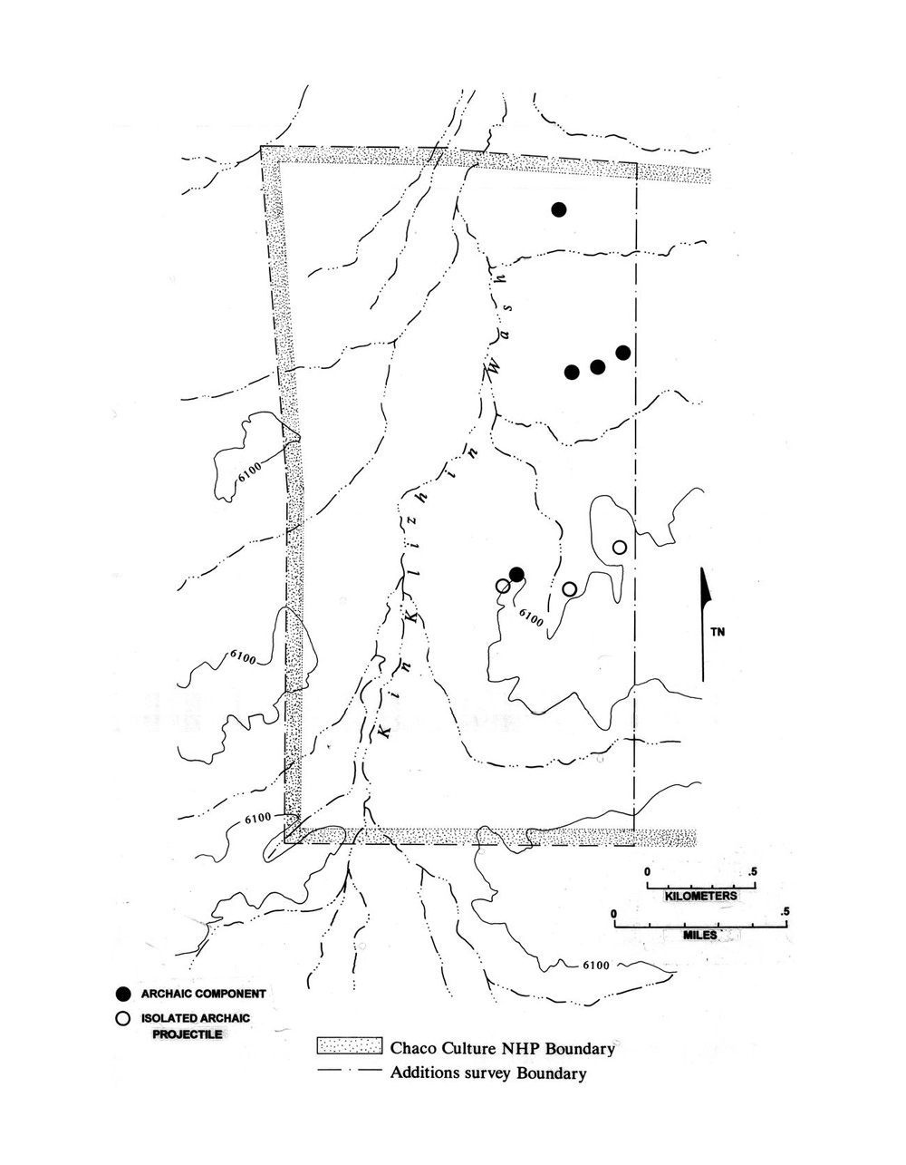 |
Figure 9.1a. Kin Klizhin survey area Archaic sites and isolates. |
¶ 18 By contrast, the Chacra Mesa sites are widely separated (Figure 9.1b). Three of the four are located on the northeast mesa flank on gentle, sandy slopes near slickrock benches which drop sharply into steep, major canyons. All are on hummocky slopes comprised of stabilized dunes with artifacts exposed in blowouts. Modern vegetation includes scattered pinyon (Pinus edulis), juniper (Juniperus monosperma), ephedra (Ephedra sp.), and winter fat (Eurotia lanata). Perennial shrubs and cacti include Atriplex, Artemisia, Gutierrezia, Chrysothanus, Opuntia, and grasses, including Oryzopsis and Sporobolus. Additional species in the slightly wetter, deep sandy soils near the mesa top include needle and thread grass (Stipa sp.) Bouteloua spp, and narrow-leaf yucca (Yucca angustissima). The proximity of three of the components to slickrock tanks at the heads of major canyons suggests that nearness to water was important for site location. The fourth site is on the west edge of the mesa top in low stabilized dunes with much the same vegetation as the other sites but fewer pinyon and juniper. This site is not directly associated with a canyon head, although slickrock with possible water collection pockets is present less than 300 m to the southwest. It is interesting that the Chacra Mesa projectile point isolates were all found on the grassy, dune-covered mesa top. No isolates were recovered in the vicinity of the canyon heads, or on the extensive juniper-covered slopes forming the east side of the mesa.
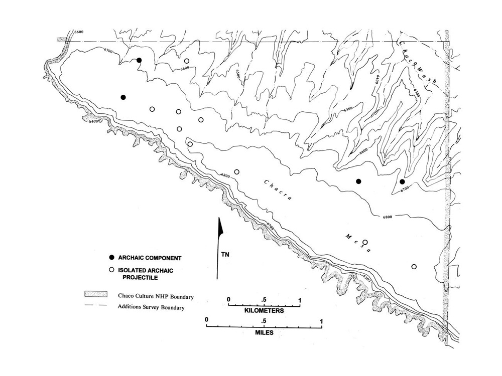 |
Figure 9.1b. Chacra Mesa survey area Archaic sites and isolates. |
¶ 19 The small sample of Archaic components, and the even smaller number that may be assigned to a temporal phase, prohibits meaningful discussion of temporal variability in structure, morphology, or size. For the same reasons, it is difficult to argue for significant temporal variability in site location or function. The components vary in size from 180 to 11,500 sq m, but the majority of each component area consists of a very low density scatter of lithic material (Table 9.2). These densities are comparable to those for camp/hearth components and lithic scatter features in general, including those representing other cultures. The majority of components have only one or two identifiable features. The most complex includes two lithic scatters, five baking pits and two cists. Fire-cracked rock scatters, which presumably indicate the presence of hearths or baking pits are the most common features after the ubiquitous lithic debris. Baking pits and cists occur together only at the complex component mentioned above. The number of features present suggests that sites were occupied by one or a few small foraging groups who used the hearths and baking pits to prepare food items gathered in the site area. The presence of cists at two components suggests limited storage. No evidence of habitation structures was evident at any of the sites.
Artifact Assemblages
¶ 20 A total of 518 chipped and ground stone artifacts were analyzed at the nine Archaic components. At eight of these, the assemblage consists of all visible surface items. At the ninth, a sample was selected for analysis. Most of the Archaic lithic material is local (97 percent) (Table 5.25; Table 5.71). Assemblages are dominated by petrified woods (cherty wood, splintery wood, chalcedonic wood) and cherts (high surface chert, miscellaneous chert/chalcedony). Exotic, or nonlocal materials only account for about 2-4 percent of the total Archaic assemblage at Kin Klizhin and Chacra Mesa (as compared to 5-6 percent at Anasazi components, 8 percent at Navajo components (Chacra Mesa only), and 3-5 percent at Other/Unknown components). Morrison Formation cherts, yellow-brown spotted chert, Narbona (Washington) Pass chert, obsidian, and Laguna chert are all present in very small frequencies. In general, the proportions for individual raw material types are indistinguishable from Anasazi, Navajo, and other/unknown assemblages in the two areas. Some apparent differences in material type proportions for the Kin Klizhin Archaic, such as the high proportion of high surface chert, may simply be a product of the small sample size. Differences are suggested only when the proportions of nonlocal materials are broken down into debitage and tool categories (Table 5.71). Nonlocal debitage accounts for a surprisingly small proportion (n = 13, 2.8 percent) of the Archaic assemblage, as do tools (n = 3, 6.7 percent), with a ratio of 4.3 pieces of nonlocal debitage per nonlocal tool. By contrast, 7.5 percent of the Anasazi debitage is nonlocal, as are 17 percent of the tools. Over five pieces of nonlocal Anasazi debitage were found for every Anasazi tool. It appears that Archaic people used fewer exotics than the Anasazi, but when nonlocal materials were used they were more likely to be tools. The debitage to tool ratio further suggests that nonlocal materials were imported or traded in reduced or preform state.
¶ 21 Additional differences are apparent in the composition of the Archaic lithic assemblages, although it is unclear if these technological markers would hold for a larger sample. The most apparent differences are a slightly higher proportion of bifacial thinning flakes (3.3 percent), a higher ratio of formal to informal tools (0.71), and a higher combined percentage of bifacially worked tools such projectile points and bifaces (23.2 percent) and a lower proportion of utilized/retouched pieces (Tables 5.31, 5.34, and 5.35). Proportions and ratios for the same classes are lower at Anasazi, Navajo, and Other/Unknown sites where the technological emphasis is on flake production rather than biface reduction. Archaic sites also have a lower proportion of utilized/retouched pieces than Anasazi, Navajo, Archaic/Anasazi and Other/Unknown site assemblages. In summary, the Archaic assemblage appears to be distinct in ways that other, larger Archaic assemblages are distinct.
¶ 22 In a similar study, Simmons (1982) compared non-diagnostic lithic materials from Archaic and Anasazi sites in the Chaco Canyon area and found a number of statistically significant differences. Lithic material from Anasazi sites represented an expedient, inferior technology when compared to material from Archaic sites. Anasazi tools were typically informal and included choppers, battered pieces, notches, and flake tools. Informal tools were rare on Archaic sites, where a greater diversity of formal tools, including bifaces and scrapers, was generally present. Archaic debitage was characterized by greater abundance, greater diversity in size, more platform reduction, and less cortex. Archaic sites had more evidence of prepared cores, less rejected cores, and a lower debitage blank/core ratio. No differences in raw materials were observed.
¶ 23 Comparison of the composition of the Chaco Additions Survey Archaic tool assemblage against that of other cultures on Chacra Mesa (Table 5.53), and against all camp components regardless of area (Table 5.54), affirms the pattern of inter-cultural differences. Archaic tool assemblages tend to look different, while Anasazi, Navajo, and Other/Unknown assemblages are more similar to each other (Figures 5.6 and 5.7). This suggests that most Other/Unknown assemblages are Anasazi or Navajo rather than Archaic. Some Archaic components may be present at these sites, but they are overshadowed by larger proportions of Anasazi material.
Anasazi Occupation
¶ 24 Anasazi sites comprise the largest portion of the Chaco Additions Survey data base. A total of 587 Anasazi sites were identified in the four additions areas. Of all the sites recorded by the Chaco Additions Survey, 61 percent contain Anasazi architectural or refuse features, 58 percent contain Anasazi ceramics, and 44 percent contain Anasazi lithics. The preceding chapters have described in detail various aspects of the surface archaeology of these sites. The objectives here are to summarize the settlement, ceramic, and lithic information, and to interpret the Chaco Additions Survey data as they bear on our understanding of great house communities in the Chacoan world.
Site Types and Settlement
¶ 25 The first research goal of the Chaco Additions Survey was to provide a general description of the Anasazi cultural remains found within the project area. Below, a few notes on terminology are presented, and general geographic and temporal summary information about Anasazi settlement is provided. Then, the Anasazi sites are discussed by site type for the entire project area. Finally, settlement patterns are summarized and discussed over time for each of the four survey areas.
Provenience Terminology
¶ 26 As discussed in Chapter 1, components and features are levels of provenience designation used by the project that are hierarchically subsumed within a site. A component is the portion of a site assigned to the same culture and site type. As such, a component may include features from one or more time intervals and embrace a variety of features used for different purposes. Each component was given a designation or site type name, usually derived from the most significant structural feature present, or in the absence of a structural feature, the dominant nonstructural feature. At most sites all the Anasazi cultural materials were treated as single component; although in a few cases two or more Anasazi components were identified at a single site. It may be helpful to remember that components are broadly defined and that the site type, is in effect, simply a classificatory label for each component.2The components established and used in the Anasazi settlement, typology and demography analysis (Chapter 2) provide an exception to this general statement. In this chapter somewhat different criteria were used during the analysis to redefine the components established in the field. In her typology analysis, Sebastian used function, space and time to create a larger number of more discrete components. For example, at site 29SJ342, Component 1 has a site type designation of habitation and includes five features: a roomblock, pithouse, hearth, trash mound and a possible kiva. Component 2, site type field house, includes two features, a field house and a sherd and lithic scatter. Component 3, site type scatter-with-slabs, has one feature, a slab scatter. All three components were placed in the A.D. 890-1025 date group, but because the components are spatially separate within the site, and are likely to have had different functions, they were distinguished. In contrast, for the ceramic (Chapter 4) and the lithic analyses (Chapter 5), only Components 1 and 2 were recognized (the components established in the the field), with the slab scatter included as a sixth feature of Component 1. Since most ceramic and lithic analyses were conducted at the feature level, component separation was of less concern. The details of component definition will be of little interest to many readers, but because the Chapter 2 components differ in number and composition, it is important to be aware that they are not precisely comparable to the components of Chapters 3 and 4.
¶ 27 Composing each component are one or more individual proveniences or features. Each provenience or feature consists of a single structural feature such as a roomblock or a hearth or a nonstructural feature such as a sherd and lithic scatter.
¶ 28 The ceramic and lithic analysts lumped site types and features into morphologically related clusters termed site type groups and feature type groups. This reduced the variety of site types and features to a manageable level and provided adequate sample populations for analysis. Most analysis was conducted at the feature level.
¶ 29 One of the site type categories—Chacoan structure—was adopted to refer to any building exhibiting one or more of the following attributes: core-and-veneer masonry, large rooms with high ceilings, multiple stories, large scale planning, direct association with a prehistoric road or great kiva, and large size and mound height relative to surrounding sites. Chacoan structures are more frequently referred to in the Chacoan literature as great houses. Both terms are used interchangeably throughout the remainder of this chapter.
Distribution of Anasazi Site Types
¶ 30 Sebastian and Altschul (Chapter 2) show that site types and site distributions are very different across the Kin Klizhin, Kin Bineola, and Chacra Mesa survey areas. The South Addition is too small to effectively characterize. These differences are due in large part to physiographic variability among the areas that rendered each appropriate for different kinds of activities. Kin Klizhin has slightly fewer components than might be expected, given its area (18 percent of the components in 21 percent of the land area), whereas Kin Bineola has slightly more components (21 percent of the components in 18 percent of the land area). Component and land area proportions are closely matched for Chacra Mesa and the South Addition.
¶ 31 Agriculture was an important activity in the Kin Klizhin and the Kin Bineola units, but the kinds of agricultural activities differed markedly, as demonstrated by differences in site types. Kin Klizhin has only 23 percent of the habitations but contains 47 percent of the fieldhouses and 40 percent of the water control features recorded by the survey. By contrast, Kin Bineola has 38 percent of the habitations but contains 64 percent of the ledgerooms, 34 percent of the scatters with slabs, and only 14 percent of the fieldhouses (Table 2.12). The Kin Bineola unit contains the largest habitation roomblocks with the highest room counts, and the Kin Klizhin unit contains the smallest habitation roomblocks with the lowest room counts. In association with the larger roomblocks, Kin Bineola contains the most and the largest trash mounds. Over 75 percent of the ceramics and lithics in the Kin Klizhin and Kin Bineola survey areas are associated with Chacoan structures, great kivas, habitations, fieldhouses and ledgerooms (Tables 4.7 and 5.83 In Tables 4.7 and 5.8 components or site types are lumped into groups often consisting of several related types. The site type group large structures includes all habitations components, small structures include fieldhouse, ledgeroom, and fieldhouse/watercontrol components, and Chacoan structure/Great Kiva includes Chacoan structures and great kivas components. See Tables 4.5 and 5.6 for listings of all the site type groupings.).
¶ 32 Agriculture was less important on Chacra Mesa. Half the recorded components are located in this unit, but these include only 28 percent of the habitations and 25 percent of the fieldhouses. Instead, Chacra Mesa has a wide variety of limited use components, many associated with hunting and gathering activities. These components include 76 percent of the sherd scatters, 59 percent of the sherd and lithic scatters, 81 percent of the hearths, 64 percent of the scatters with hearths, 83 percent of the baking pits, 56 percent of the cist/storage components, 87 percent of the trails, and 83 percent of the rock art (Table 2.12). This vast and dense array of non-residential features indicates that Chacra Mesa was used intensively by Chaco Canyon residents.
¶ 33 Although there are relatively few Anasazi habitation components on Chacra Mesa, those that are present are larger than habitations found in the other three areas (Table 2.13). This reflects the higher percentage of pithouses on Chacra Mesa (49 percent), as compared with Kin Bineola (14 percent) and Kin Klizhin (10 percent). Over half of all ceramics found on Chacra Mesa are associated with habitations. Trash mounds, rare at pithouse villages, are correspondingly rare on Chacra Mesa. Fieldhouses on Chacra Mesa are substantially larger, perhaps reflecting more intensive use which may in turn be a result of greater distance from habitations. Hearths, baking pits, and scatter with hearth components are larger on Chacra Mesa than elsewhere, reflecting the repeated use of these components over long periods. Most lithics on Chacra Mesa were associated with hearth/camp-like sites (Table 5.8).
Temporal Variability
¶ 34 The Anasazi sites are dated by means of surface ceramics. Mills (Chapter 4) explains how a cluster analysis was used to define five largely discrete date groups (hereafter abbreviated as DG). A total of 736 features with use spans of less than 200 years were included in this procedure (Table 4.11); an additional 100 features had use spans longer than 200 years and were not included. Minor overlaps and gaps between the beginnings and ends of the date groups reflect clustering of the ceramic beginning and end dates assigned to each site provenience. Table 9.3. summarizes this information for ease of reader reference. For purposes of clarity, date ranges as well as DG designations are provided in the discussions that follow. The periods represented by the date groups approximate those used by the Chaco Project (Lekson 2006: Figure 1.3).
|
Table 9.3. Summary of ceramic date groups. |
|||
|---|---|---|---|
| Date Group | Dates (A.D.) | Number of Features | Approximate Chaco
Project Phases (Figure 1.3 in Lekson 2006) |
| 100 | 550-750 | 124 | La Plata |
| 200 | 700-880 | 65 | White Mound, Early Bonito |
| 300 | 890-1025 | 169 | Early Bonito |
| 400 | 1030-1130 | 331 | Classic and Late Bonito |
| 500 | 1130-1230 | 47 | Mc Elmo, & Mesa Verde |
A.D. 550-750 (DG 100)
¶ 35 During the A.D. 550-750 period, settlement consists primarily of pithouse habitations and scatter-with-hearth components (Table 2.15). “Hearth” was coded whenever burned slabs were present, and Sebastian and Altschul suggest that scatter with hearth components are likely to include unrecognized pithouses. More than 20 percent of the components of each of these types date to the A.D. 550-750 period. There is an average of 0.4 components per year during this period across all four survey areas, although, settlement was focused on Chacra Mesa and the South Addition (Table 2.20). Nearly half of the habitations on Chacra Mesa, and 40 percent of those on the South Addition, were occupied during this period. Over 70 percent of the sherds and lithics from this period are from Chacra Mesa (Tables 4.14 and 5.11), and most of these artifacts are associated with large structures (habitations) (Tables 4.15 and 5.12). The majority of the habitations are part of the large Basketmaker III pithouse community surrounding Shabik’eshchee Village.
A.D. 700-880 (DG 200)
¶ 36 During the A.D. 700-880 period, settlement still consists primarily of habitations, although fieldhouses and ledgerooms are increasingly prevalent (Table 2.15). There is an average of 0.2 components per year from this period across all survey areas. This largely reflects a drop in occupation on Chacra Mesa and the South Addition. The number of sites at Kin Klizhin increases incrementally, but Kin Bineola is the only area with substantial occupation between A.D. 700-880 (Table 2.20); over 50 percent of the total period artifact assemblage is from Kin Bineola (Tables 4.14 and 5.11). Interestingly, the temporal overlap between DG 100 (A.D. 550-750) and DG 200 (A.D. 700-880) suggests that the Pecos Classification break between Basketmaker III and Pueblo I settlement does not coincide with a change in ceramic types. The drop in the number of habitation components (Table 2.15) during this period may partially reflect the period’s short span, as well as its partial overlap with DG 100 (A.D. 550-750), but much of the decline appears to reflect the abandonment of the mesa slope Shabik’eshchee community in favor of lower elevation canyon bottom locations outside the Chacra Mesa survey area. In his survey of Chaco Canyon National Monument, Hayes (1981: 23-27) found that 32 % of Basketmaker III sites (comparable to DG 100) were on mesas whereas only 9% of Pueblo I sites (DG 200) were similarly located. This preference for bottomland locations continued during the subsequent Pueblo II and III periods (Hayes 1981: Figure 14). The relative absence of habitations on Chacra Mesa in subsequent date groups, and the steady increase of habitations in lowland areas at Kin Klizhin, Kin Bineola, and the South Addition suggest a broad shift in topographic preference.
A.D. 890-1025 (DG 300)
¶ 37 During the A.D. 890-1025 period, occupation increases dramatically to an average of 0.8 components per year across all survey areas (Table 2.15). Occupation is well represented in all four survey areas (Table 2.20). Habitations remain common, but settlement is dominated by a variety of non-structural sites, such as ceramic scatters, ceramic and lithic scatters, scatter with slab or hearth components, and baking pits. Baking pits reach their highest frequency during the A.D. 890-1025 period. Fieldhouses increase in frequency as well as size (Table 2.19), although the number of rooms per structure remains constant (Table 2.18). On Chacra Mesa, most ceramics and lithics are associated with hearths; in the other three survey areas, most ceramics and lithics are associated with habitations or small structures (fieldhouses and ledgerooms) and with Chacoan structures and great kivas, where present (Tables 4.15 and 5.12).
A.D. 1030-1130 (DG 400)
¶ 38 Occupation reaches its zenith during the A.D. 1030-1130 period (Table 2.15). There is an average of 2.0 components per year across all survey areas. Habitations, fieldhouses, ledgerooms, ceramic and lithic scatters, and scatter with slab and hearth components occur in their greatest numbers and highest proportions during this period. Roomblocks and ledgerooms increase in overall size and number of rooms (Tables 2.18 and 2.19). Fieldhouse and scatter with slab components are especially common at Kin Klizhin and Kin Bineola. Sebastian and Altschul found that the frequencies of fieldhouses, ceramic and lithic scatters, and scatter with slab components closely parallel one another in both the A.D. 890-1025 (DG 300) and the A.D. 1030-1130 (DG 400) periods, suggesting that these may be functionally identical or complementary components.
¶ 39 Over 40 percent of all ceramic and lithic scatters recorded on the project are from the A.D. 1030-1130 period (Table 2.15). These proportions are especially meaningful since the A.D. 1030-1130 period is one of the shortest of the five date groups, spanning only 100 years. Most artifacts are found in association with habitations (large structures), small structures, Chacoan structures and great kivas, where present (Tables 4.15 and 5.12).
A.D. 1130-1230 (DG 500)
¶ 40 Occupation declines precipitously during the A.D. 1130-1230 period (Table 2.15). There is an average of only 0.3 components per year across all survey areas. Only a few scattered habitations and fieldhouses are present. This period has the smallest artifact assemblage and the smallest number of proveniences (Tables 4.14 and 5.11). Kin Klizhin and Chacra Mesa contain most of the material. The South Addition is not occupied at all.
Description of Component Types
¶ 41 Below, the basic morphological and architectural characteristics of the six major component types—Chacoan structures, great kivas, roads, habitations, fieldhouses and ledgerooms, and water control features—are summarized and described. The remaining “other” component types are described in aggregate.
Chacoan Structures
¶ 42 The most distinctive form of Chacoan architecture is the great house. Great houses are also sometimes termed great pueblos, towns, or, as in the present study, Chacoan structures (Morris 1939; Powers et al. 1983; Lekson 1984). Chacoan structures exhibit substantial functional, temporal, and spatial variability (Van Dyke 1999b). For the purposes of this study, Chacoan structures are defined as planned, massive, often multi-storied buildings exhibiting compound or core-and-veneer masonry, large rooms with high ceilings, and large circular kivas with a corpus of distinct features. As emphasized previously, Chacoan structures differ architecturally; not every Chacoan structure exhibits all of these features. Chacoan structures vary greatly with respect to size (Powers et al. 1983:Table 41). Most of the largest are found in Chaco Canyon, while medium and smaller-sized Chacoan structures are the foci of outlier communities.
¶ 43 Four Chacoan structures were recorded by the Chaco Additions Survey. These include: Kin Klizhin, Kin Bineola, 29Mc 291 (an unnamed structure in the Kin Bineola survey area), and 29SJ 2384 (an unnamed structure at the north foot of Chacra Mesa). The three structures outside the canyon are the focal point of outlier settlements. 29SJ 2384, although inside the canyon, is smaller in size than most canyon great houses. Its relationship to settlement in central Chaco Canyon is unclear.
¶ 44 The Kin Klizhin Chacoan structure (29SJ 1413) (Figures 2.6 and 2.7a, b, c) is situated prominently on a low ridge in the center of the Kin Klizhin survey area along lower Kin Klizhin Wash approximately 11 km southwest of central Chaco Canyon. As discussed in Chapter 1, Kin Klizhin has been described by many previous investigators (Bannister 1964; Bannister et al. 1970:24; Hewett 1905, 1936; Holsinger 1901; Judd 1954:57; Marshall et al. 1979:69-72; Morrison 1876; Powers et al. 1983). This small rectangular two-to-three-story great house contains 13 visible and 20 estimated rooms. There are two enclosed kivas, in addition to an impressive three-story tower kiva surrounded by massive walls 6 m high. Rubble remnants of a possible plaza wall connect the north and south ends of the roomblock. There are no clear surface indications of subterranean structures in the plaza. A dune obscured trash mound is located to the southeast of the plaza, near a possible road segment, and a large, diffuse trash scatter spreads to the northeast. Ceramics from these features date between A.D. 1050-1175 and the site was placed in the A.D. 1030-1130 (DG 400) date group. This date range fits well with tree-ring dates published by Bannister et al. (1970:24) (see Chapter 1), indicating construction in the A.D. 1080s.
¶ 45 The tower kiva is a relatively rare construction with symbolic implications. Tower kivas are more than simply second-story kivas; rather, they consist of three to four vertically stacked enclosed kivas (Marshall et al. 1979:18). Possible tower kivas are also found at two Chaco Canyon great houses–Chetro Ketl and Kin Kletso (Lekson 1984:52)–and four outliers in addition to Kin Klizhin: Salmon, Kin Ya'a, Haystack, and possibly Upper Kin Klizhin (Marshall et al. 1979:15-16). No regional patterning among tower kivas is discernible (Van Dyke 1998). Some researchers have proffered the idea that tower kivas functioned as part of a signaling network (Hayes and Windes 1975; c.f. Lekson 1984:52). Marshall et al. (1979:204) speculate that tower kivas may represent the underworlds of Puebloan mythology in which the ancestors of the human race live in succession before emerging into the contemporary world.
¶ 46 Two Chacoan structures are present in the Kin Bineola survey area. The Kin Bineola Chacoan structure (29SJ 1580) is located on open terrain approximately 18 km southwest of centra l Chaco Canyon (Figures 2.8 and 2.9). This massive, E-shaped structure faces the south-southeast. Like Kin Klizhin, Kin Bineola has been described by many previous investigators (Bannister 1964:68-170; Bannister, et al. 1970:20-21; Hewett 1905, 1936; Holsinger 1901; Judd 1954; Lyons et al. 1972; Lyons and Hitchcock 1977; Marshall et al. 1979:57-68). The three-story structure has an estimated floor area of 8,225 m2. It is the third-largest outlier great house, exceeded in size only by Aztec West (15,030 m2.) and Salmon (8,320 m2.) (Powers et al. 1983:Table 41). There are two squarish plazas, and portions of third story walls stand along the north-facing spine. A total of 200 rooms is visible, and this project estimated an additional 30 rooms are likely to be present. Ten kivas are enclosed within the roomblock and a slight depression with scattered rubble west of the great house may represent an associated great kiva. Thirteen trash mounds are scattered to the south of the Chacoan structure. An additional trash mound, 29SJ 2531, was assigned a separate site number. Most appear to be composed primarily of construction debris, but ceramics and lithics are also present. Surface ceramics from the trash mounds indicate occupation of the site between A.D. 890 and 1130 (DG 300 and 400). This ceramic range fits well with the two construction episodes documented by Bannister (1964:68-170; Bannister et al. 1970:20-21) at A.D. 942-43 and A.D. 1111-1120.
¶ 47 The Chaco Additions Survey discovered a second, previously unknown Chacoan structure within the Kin Bineola addition. This structure, 29Mc 291, is located in the southeastern part of the survey area (Figures 2.10 and 2.11a, b, c). The building is identified as a Chacoan structure on the basis of compound/core-and-veneer masonry, large rooms, substantial mound height, and presence of a possible enclosed kiva. There are 9 visible and 13 estimated rooms present in the one-story structure. Two kivas may be buried in an open plaza area. Three trash mounds are located to the south and east. Surface ceramics date the occupation of the structure to A.D. 890-1130 (DG 300 and 400). As discussed in more detail below, 29Mc 291 was the focus of a cluster of habitation sites occupied between A.D. 890-1130.
¶ 48 The Chacra Mesa addition contains the badly eroded foundation of an apparently unfinished great house with an estimated 40 rooms (29SJ 2384) (Figures 9.2 and 9.3). This structure is located on the main canyon floodplain near the mouth of a northward-draining tributary of Chaco Wash in the northeast corner of the Chacra Mesa survey area. The site was excavated by Frank H. H. Roberts, Jr. in 1926 as reported by Windes (1987:141-142). The building’s walls were erected to a uniformly unfinished height, leading Roberts to propose that the structure was never completed, rather than razed and abandoned. Ceramics from the site date between A.D. 800-1150. These are thought to be associated with an underlying structure abandoned prior to the construction of the great house foundation.
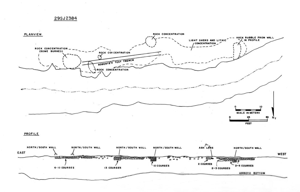 |
Figure 9.2. Plan and profile views of the unfinished Chacoan structure (29SJ 2384) at the north foot of Chacra Mesa. |
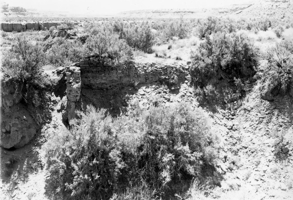 |
Figure 9.3. View of exposed Chacoan structure (29SJ 2384) masonry in arroyo cut. |
Great Kivas
¶ 49 In addition to the possible great kiva associated with the Kin Bineola Chacoan structure, two “isolated” great kivas were identified by the survey. The first, 29SJ 2557, is located in a side canyon of Chacra Mesa near 29SJ 2384, but is not directly associated with the unfinished Chacoan structure. Great kiva 29SJ 2557 is 13 m in diameter, with three attached rooms and a trash mound to the east (Figure 2.4). Surface ceramics from the trash mound date between A.D. 1075-1225, (the site was dated to 1130-1230 [DG 500] by the cluster analysis) thereby bracketing the period during which construction of the nearby Chacoan structure was likely initiated and abandoned.
¶ 50 The second great kiva, 29Mc 261, is located in the Kin Bineola survey area on a broad mesa top on the east side of the valley, approximately 3 km south of the Kin Bineola Chacoan structure. The great kiva is northwest of the nearby Chacoan structure 29Mc 291. The great kiva is 13 m in diameter and has a number of surrounding rooms (Figures 2.5 and 9.4). There are two roomblocks immediately to the north. A trash mound to the south contains surface ceramics dating between A.D. 700-1000. The site is near the physical center of a tight cluster of habitation sites occupied between A.D. 700 and 1025.
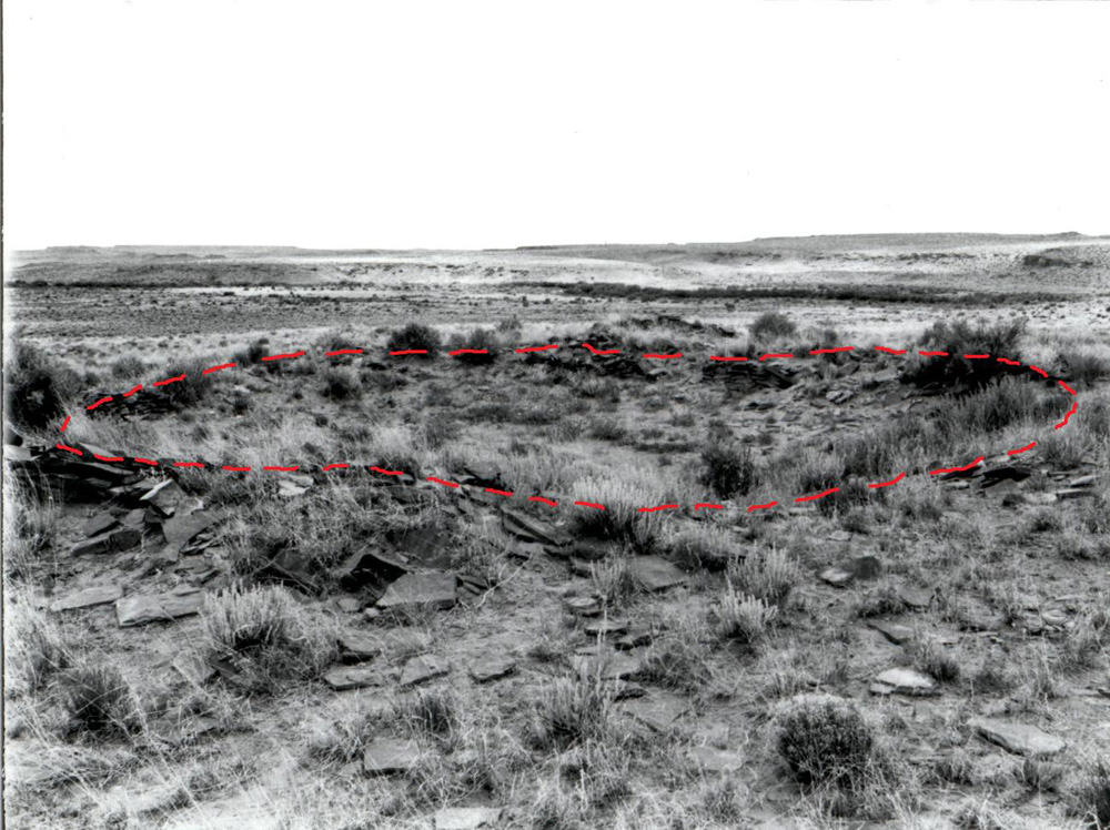 |
Figure 9.4. View of the great kiva (29Mc 261) in the southern portion of the Kin Bineola survey area. Dashed red line marks kiva perimeter. |
Habitations
¶ 51 The term habitation or large structure was used by the Chaco Additions Survey to refer to Anasazi residential structures. These include pithouses, pithouses associated with jacal or masonry roomblocks, and masonry pueblos. While Chacoan archaeologists rather consistently refer to early subterranean dwellings as pithouses, later, above-ground structures have been variously termed unit pueblos, Bc sites, villages, small pueblos, and small sites (McKenna and Truell 1986; Prudden 1903; Vivian and Mathews 1964; Vivian 1970). Our habitation designation includes this entire range. Habitations are the most common of the 24 component types identified in the settlement analysis (Table 2.15). Pithouse (n = 34), pithouse and roomblock (n = 44), and roomblock (n = 55) components together account for 18 percent (n = 133) of the settlement data base (Table 2.17). Habitations occur nearly twice as frequently as the next most common type, fieldhouses.
¶ 52 The earliest Anasazi habitations in the study area are pithouses, which predominate during the A.D. 550-750 (DG 100) period. Some pithouse and roomblock components are also present during this period. Pithouse-only components are less frequent through time, with the last examples recorded during the A.D. 890-1025 (DG 300) interval. It is somewhat surprising that pithouse-only components are found this late in time, although McKenna and Truell (1986:231-233) found that pithouses associated with roomblocks were occupied as habitations in Chaco Canyon until the mid-eleventh century.
¶ 53 The average pithouse habitation on the Chaco Additions Survey contains 1.7 visible and 3.2 possible pithouses. This average is inflated by the inclusion of Shabik’eshchee Village (located within the Chacra Mesa survey area), with 18 known pithouses (Roberts 1929) and 49 possible pithouses. If Shabik’eshchee is excluded, the average pithouse habitation contains 1.1 visible and 1.8 possible pithouses. Pithouse components average two cists each, although again the average is significantly affected by the inclusion of Shabik’eshchee. These averages are comparable to the three pithouse, three cist average documented by Hayes in his survey of Chaco Canyon (1981:23), although Hayes considered his average to be low based on the results of subsequent Chaco Project excavations. The Chaco Additions Survey averages are probably low as well; given the sparse surface remains and the aeolian or alluvial locations chosen for most pithouse sites, many features are undoubtedly buried.
¶ 54 No patterning is evident in the arrangement of pithouses at pithouse-only habitation sites. Sebastian and Altschul contend the lack of spacing between house depressions may reflect successive rather than contemporary occupation. Site layout varies with the terrain, but refuse scatters tend to be located to the southeast of pithouse clusters.
¶ 55 At roomblock habitations (both with and without pithouses), the average component consists of a single building with three visible rooms and an additional four possible or estimated rooms. It is difficult to compare the Chaco Additions Survey room counts through time with the room counts recorded by Hayes because of differences in the time periods employed, the sampling strategy, and the procedures used to estimate room counts. It seems likely, however, that Hayes’ (1981: 27, 31, 33) low early Pueblo II (4.3 rooms) and early Pueblo III (5.5 rooms) room count estimates reflect methodological differences. His early Pueblo II (A.D. 900-975) is most comparable to the Addition survey’s DG 300 (890-1025) period when Sebastian and Altschul estimated 8.1 rooms per roomblock, while his early Pueblo III (A.D. 1050-1175) includes most of the DG 400 (1030-1130) time period where the Additions Survey estimated 8 rooms per roomblock (Table 2.18). Late Pueblo III (A.D. 1175-1300) canyon sites as recorded by Hayes do appear to be larger (16.0 rooms), on average, than A.D. 1130-1230 (DG 500) habitations (6.2 rooms) recorded by the Chaco Additions Survey, but without larger and more comparable samples, this assertion is an educated guess.
¶ 56 The layout of pithouse and roomblock habitations follows the pattern characteristic of Chacoan sites. Roomblocks form arcs or alignments extending from the northeast to the southwest, facing the southeast. Pitstructure depressions are located to the east or southeast; refuse features are situated just beyond. The pithouse to kiva transition in Chaco appears to take place late and over a substantial period of time. A similar situation is assumed for the Chaco Additions sites. Sebastian and Altschul report that pithouse-and-roomblock components average 0.2 pithouses and 1.6 possible pithouses, and 0.3 kivas and possible kivas per component. Since it was difficult to separate pithouses from kivas at intermediate period habitations, it is perhaps more accurate to say that these components had an average of 0.5 pitstructures and 1.9 possible pitstructures per site.
¶ 57 At habitation components containing only roomblocks, there is an average of 0.9 kivas per structure. Trash mounds are associated exclusively with roomblock or pithouse-and-roomblock components. When present, trash mounds are usually found to the southeast of the plaza. Refuse scatters are found with roomblock only components as well as with pithouse-and-roomblock, and pithouse only components. Extramural features such as concentrations of slabs and/or fire-cracked rock, hearths, baking pits, and cists are less frequent than at pithouse components. These features are found anywhere on roomblock only sites except behind the structure.
Fieldhouses and Ledgerooms
¶ 58 Fieldhouses are the third most common type of component recorded by the Chaco Additions Survey (n = 72, 10 percent (Table 2.12). Ledgerooms are about half as numerous (n=36, 5 percent). Fieldhouses and ledgerooms are quite similar except that fieldhouses are free-standing structures, while ledgerooms are built against a cliff or boulder face, using that surface for at least one wall. By definition, both fieldhouses (1.1 rooms visible; 1.4 rooms estimated) and ledgerooms are limited to two rooms, but both average one visible or estimated room.
¶ 59 Several configurations of fieldhouses were recorded by the survey. Rubble concentrations with a few alignments or upright slabs and a light artifact scatter are generally on the ends of low ridges adjacent to floodplains. Components with multiple fieldhouses are similar; each has its own artifact and rubble scatter. Over half of the fieldhouses are associated with unburned slab or fire-cracked rock scatters. Baking pits and cists are found with a smaller number of components. Water control features are also sometimes present. Components with multiple fieldhouses probably represent recurrent uses of favorable locations, although it was usually impossible to determine if these components represented contemporaneous or successive activities.
¶ 60 Ledgerooms were commonly associated with hearths and baking pits. While habitation components contain an average of 6.7 extramural features, fieldhouses and ledgerooms contain an average of 2.8 features.
¶ 61 In Chapter 2 Sebastian and Altschul performed a series of cluster analyses to evaluate the site typology and found several noteworthy ceramic assemblage patterns. Early fieldhouse assemblages (A.D. 550-880, DG 100 and 200) are dominated by plainwares, as are habitation assemblages from these periods (Table 2.21). Fieldhouse ceramic assemblages from A.D. 890 onwards exhibit more variability. Three kinds of assemblages were identified from the A.D. 890-1025 (DG 300) period–one dominated exclusively by plainware, one containing plainware and decorated jars, and one containing plainware and decorated bowls. Between A.D. 1030-1130 (DG 400), two kinds of assemblages were identified–those dominated by plainware with a minority decorated assemblage led by jars, and others composed of approximately equal frequencies of plainware and decorated ware, but with jars dominant in the decorated portion of the assemblage. A few of the decorated assemblages are dominated by bowls. Assemblages from the A.D. 1130-1230 (DG 500) period are as variable as the A.D. 890-1025 (DG 300) assemblages. These ceramic assemblage differences may indicate different functional and/or durational differences among the fieldhouses of the later periods, or as is discussed later in this chapter, the differences may reflect lack of stabilization in vessel breakage rates.
Roads
¶ 62 At the time of the survey, it was believed that a prehistoric road system linked the great houses in Chaco Canyon with most Chacoan structures in outlier communities. In each of the survey areas containing a Chacoan structure, the discovery of road segments was anticipated. Obenauf’s (1980 : 59-60) prehistoric road mapping project, which plotted all potential road segments visible on aerial photography suggested that both Kin Klizhin and Kin Bineola were way points on the Mexican Springs road which extends south-southwest from South Gap in Chaco Canyon to the area of the present-day Navajo community of Mexican Springs in the Tohatchi Flats. Despite constant scrutiny by the survey crews, only one possible road segment and an herradura were identified at Kin Klizhin. One possible segment was also identified at Kin Bineola.
¶ 63 The potential road in the Kin Klizhin survey area is a short segment represented by a swale climbing the northeast edge of the Chaco structure promontory. Roads, usually visible as swales, often approach Chacoan structures from the north or northeast (Fowler et al. 1987; Kincaid 1983; Powers et al. 1983). A second feature at Kin Klizhin has no visible road, but is almost certainly an herradura. This site (29SJ 2420), located on a ridge formed by rock outcrops is elevated and has good visibility. The structure is horseshoe-shaped, approximately 2 m in diameter, with low, possibly dry-laid masonry walls and an entryway to the east. A sparse scatter of sherds and lithics is located to the northwest.
¶ 64 At Kin Bineola an alignment of large boulders forms what may be a road border at the base of a high promontory 300 m southeast of Kin Bineola great house (Figure 2.27). These boulders and a hearth compose site 29Mc 251.
¶ 65 As originally mapped by Obenauf, the Mexican Springs road headed southwest out of South Gap, before curving and heading due west to the Kin Klizhin great house. Two short segments were visible in the southern half of the survey area, heading west to the great house, and another two equally short segments were plotted immediately west and southwest of the Chaco structure (Obenauf 1980:101). Obenauf walked portions of this section of the road, but none of the photographically defined segments was visible on the ground. She noted that while the alignments “could not be definitely identified as a road,” they “did not prove to be anything else.” No further segments were visible over the remaining nearly seven kilometer distance to Kin Bineola, but a little more than a kilometer southwest of the Kin Bineola great house, several more segments with a southwest-northeast orientation were visible. As Obenauf notes, a backward projection of the alignment formed by these segments would lead directly to the Kin Bineola great house. Subsequent work by Stein and Levine (1983) and Nials et al (1987) identified an additional three alignments visible on aerial photography, one of which is a 0.8 km alignment associated with the Yellow Point Herradura. These features, oriented southwest to northeast, are located east of the Kin Bineola great house (Nials et al. 1987: 112-113). The alignment of the two segments most closely associated with the herradura, if projected to the northeast, would eventually lead to the 29SJ 2420 herradura in the Kin Klizhin survey area. While Nials et al (1987: 11-14, 112-113) stress that these segments have not been verified on the ground, they emphasize that the segment associated with the Yellow Point herradura was clearly visible during aerial reconnaissance, and they argue that herraduras are reliable indicators of prehistoric roads.
¶ 66 Although very little on-the-ground verification of these photo identified alignments has taken place, the combined evidence presented by the various possible road alignments, the herraduras, and other features observed by the survey suggests that Kin Klizhin and Kin Bineola are linked to each other, to Chaco Canyon, and potentially to other outliers by the Mexican Springs road. However, even if all or many of the projected alignments are ultimately verified, it is difficult at present to understand precisely how the segments link together. Both herraduras and the alignments identified by Nials et al. establish a uniform trajectory, but it is a trajectory that on its western end seems to pass 0.8 km south of Kin Bineola, and on its eastern end, 1.5 km south of Kin Klizhin (Roney 1992: 126), although a continued projection to the east would eventually meet the long curved segment of road identified by Obenauf coming out of South Gap.
¶ 67 Although this is highly speculative, it appears to Powers that the Obenauf alignments in the immediate vicinity of Kin Klizhin great house may be segments of a side road that diverges from, and latter rejoins the main road trajectory suggested by the herraduras and the photographically identified alignments defined by Nials and his colleagues. On the western end of this same trajectory, it appears that the road enters the Kim-mi-ni-oli Valley through a side-drainage just south of Kin Bineola, before curving north to the great house. This detour would have minimized the construction challenges of a more direct approach from the northeast, that would have entailed negotiating the cliff face behind the great house. Southwest of Kin Bineola the nature of the Mexican Springs road is even more uncertain. Nials et al (1987:24) note that although several “photolineations,” have been identified, on the day an aerial reconnaissance was conducted, none of them were visible. They also explain that the alignment of the road is the same as a series of aeolian dunes, raising the prospect that the alignments are not cultural. As this discussion indicates, careful and detailed fieldwork following the model established by the Bureau of Land Management is needed to further clarify the route of the Mexican Springs road.
¶ 68 No prehistoric road segments were identified on Chacra Mesa, but a prehistoric road is thought to run along the bottom of upper Chaco Canyon, linking Pueblo Pintado with the central canyon (Roney 1992:126). The extensive erosion and alluviation on the canyon bottom north of the Chacra Mesa survey area make identification of road segments unlikely. If a road did once extend along the canyon floor, it would have necessarily passed within several hundred meters of 29SJ 2384, the unfinished Chacoan structure.
Water Control
¶ 69 The Chaco Additions Survey recorded a total of 30 water control components (4 percent of all components) (Table 2.12), including 4 major dams, 8 linear features possibly representing ditches or canals, 27 check dams, and 10 other water control features of undetermined type. Water control features do not lend themselves easily to computerized analysis because of their small numbers and variable forms. The smaller, more common features are described by type, and the large, exceptional features are described individually.
¶ 70 When the Chaco Additions Survey was conducted a number of problematic linear features were identified. Most were described as potential water control features. Shifts in interpretive perspective over the past two decades have resulted in suggestions that some of these features served other functions. Because of the continuing uncertainty about what purpose such features actually served, water control features recorded at Kin Klizhin and Kin Bineola were revisited by Van Dyke and Powers in May of 2001. Water control still appears to be the best explanation for some of these features, but not for all of them. Below, impressions gleaned during the 2001 visit are incorporated into a discussion of the features originally recorded as dams, canals, and head gates.
Kin Klizhin
¶ 71 At Kin Klizhin, there are a variety of features which appear to be elements of both large and small scale water control systems. The small scale systems are found in the tributary drainages to Kin Klizhin wash on the east side of the valley. These include head gates, a ditch segment, and a variety of small slab scatters. The head gates consist of upright slabs spaced at intervals of 30-40 centimeters with a horizontal splash stone forming the bottom of the feature. At one headwater, a shaped slab was found which may have been used to close the gate. The ditch segment consists of a 20 m long alignment of upright slabs associated with one of the gates.
¶ 72 The large scale systems are found in the main valley bottom. These include a dam, a spillway, and possible canal segments. The largest and most visible of these is a system (29SJ 2444) consisting of a masonry-lined earthen dam, a bedrock spillway, and a possible canal (Figures 9.5 and 9.6). This system is clearly designed to control and channel main wash flood water. Early observers thought the system capable of irrigating several hundred acres of floodplain north of the dam (Hewett 1905; Holsinger 1901; Morrison 1876). Today only the dam and the spillway are visible. The dam spans the narrowest portion of the valley floodplain immediately east of the Kin Klizhin Chacoan structure. This feature, as shown in Figure 9.5 consists of two sections, a West Dam and an East Dam, divided by a gap that appears to have been created by a combination of flooding of the Kin Klizhin Wash channel, and the construction of a modern (Navajo built) earthwork utilizing dirt from the middle section of the prehistoric dam. Although the East and West segments of the dam appear to be somewhat offset from each other, Gwinn Vivian (personal communication 2012) believes they once formed a single structure. While the West Dam is low and rather indistinct, the East Dam is clearly visible for approximately 45 m before terminating in a “cut” or spillway that was excavated in the bedrock anchoring the east end of the dam. This spillway is shown in Figure 9.5 as the opening between two bedrock remnants (with recently piled stones partially blocking the channel) and in Figure 9.6 as the “cut.”
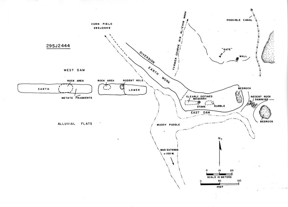 |
Figure 9.5. Plan view of Kin Klizhin dam and spillway (29SJ 2444). |
¶ 73 The East Dam was first described by Lieutenant C.C. Morrison (1876). It is 3 m wide at the top, 4.6 m wide at the base, and is 1.5 m high. A low masonry wall or “revetment” runs parallel with the crest. Morrison (1876) also reported a levee on the margin of the dam pool, which probably corresponds with the low earthen feature the survey identified as the West Dam. He thought this feature might have been used to concentrate water in the dam pool so that agriculture could be practiced around its margins. Test excavations were conducted along the face of the (East) dam by Gordon and R. Gwinn Vivian in the 1960s and early 1970s (R. G. Vivian n.d.; Figure 9.6). The Vivians’ work confirmed Morrison’s initial observations and revealed a 2 m-wide span of core-and-veneer lining on the north and south faces of the dam. The dam’s interior is earthen, although in its middle section, where the wash now runs, it appears to be solid masonry.
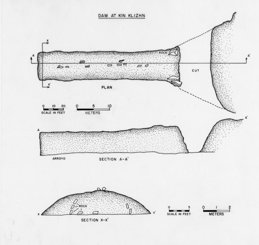 |
Figure 9.6. Plan and profile views of Kin Klizhin dam ( 29SJ 2444) as drawn by Gordon Vivian. |
¶ 74 The “cut” or spillway at the east end of the East dam is 24 m long, 4 m wide, and 2 m deep, and cuts through the bedrock ridge attached to the east end of the dam (Figure 9.6). Early observers reported a possible canal at the north end of the spillway (Holsinger 1901; Morrison 1876), but no depression has been visible in that area since at least the 1960s (R.G. Vivian n.d.) A possible head gate (29SJ 2510) consisting of two upright slabs is found 350 m north of the spillway; it may be associated with this canal. Two possible checkdams (29SJ 2460) consisting of two 6 m-long slab alignments are located on the west margin of the valley approximately 500 m north of the spillway, but it is possible that these “features” are nothing more than rubble from test excavations conducted in this area by Gordon Vivian. Gordon Vivian tested a possible canal segment on this spot. According to his field notes, the canal was slightly concave in cross-section, with a slab lining 1.2 to 1.5 m wide located 2.8 m below the modern ground surface. Vivian followed the slab pavement for approximately 10 m. Although the east side of the feature was removed by arroyo action, and the west side is described by Vivian as “indistinct,” a total width of 3.6 m was proposed for the canal.
¶ 75 Two problematic linear features were identified by the survey crew further to the north. These features were interpreted as possible canals by the survey, but when the authors revisited both sites in May 2001, this function seemed unlikely. The first of these features, 29SJ 346, is located on the west side of the valley in the far northwestern corner of the survey area. A slight depression 9 m wide parallels the base of a small knoll along the edge of the valley for approximately 95 m. A barely discernible berm littered with residual gravel marks the east side of the depression. In 2001, a cattle trail followed part of the depression, then branched off to the east. The feature does not appear to be natural, yet there is little to indicate that it functioned as a canal. It may be the bed of an old cattle trail, game trail, or wagon road.
¶ 76 29SJ 2517, on the east side of the valley, is a 5 m wide depression traceable for 223 m along the east side of Kin Klizhin wash between the wash and a two-track road. This linear depression was originally documented as a prehistoric canal segment. The feature was much less distinct in 2001 when the authors revisited the area. The most likely interpretation for this feature is that it is a segment of an old wagon road or two-track that captured water for a time but has since filled in.
Kin Bineola
¶ 77 At Kin Bineola, all water control features are of the large scale variety. It is possible that small scale features are buried by alluvium in tributary drainages. In the following discussion, the features are described geographically from south to north, concluding with the Teardrop Mesa canal system located southwest of the Kin Bineola Chacoan structure. As at Kin Klizhin, the interpretation of some sites originally described as water control features is open to debate. Nevertheless, because they were considered to represent water control features when recorded, problematic linear alignments are included in this section.
¶ 78 A slab-surfaced dam (29Mc 330; Figure 9.7) is situated on the west edge of Kim-mi-ni-oli Wash in the south central part of the survey area. The dam is approximately 5 m wide, 10 m long, and 75 cm high; it appears to be the remains of a larger structure. Slabs in the bottom of the wash suggest the feature once extended further to the east, where it may have impounded water from the main wash. At the west end of the feature, a wide, shallow swale appears suited for collecting run-off from a small tributary drainage.
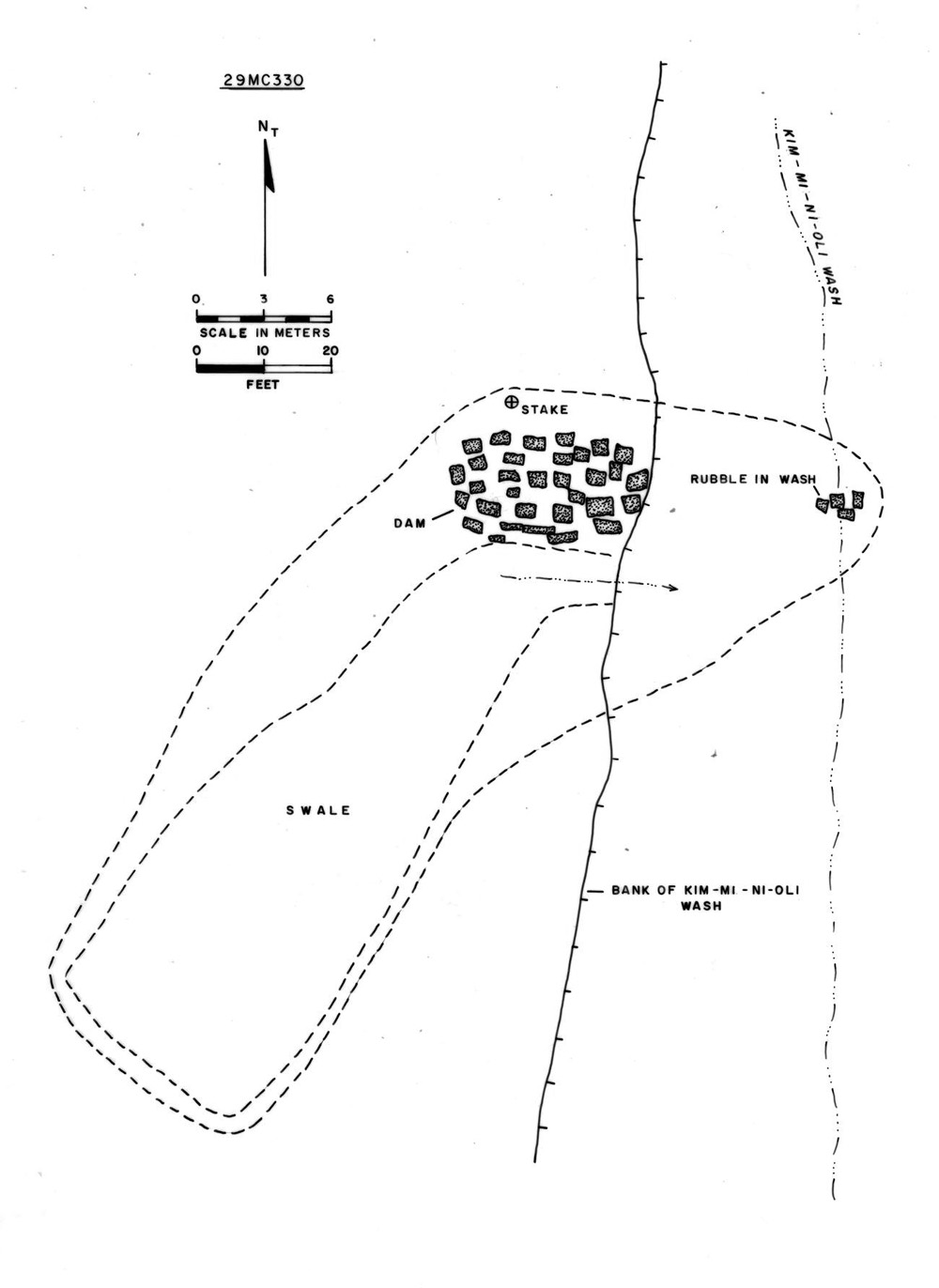 |
Figure 9.7. Plan view of dam (29Mc 330) in the Kin Bineola survey area. |
¶ 79 A problematic linear swale and a second possible masonry dam (29Mc 332; Figures 9.8 and 9.9) are located downstream approximately 150 m to the northeast. The dam consists of two rubble piles on the east and west edges of the wash, respectively, parallel with a bedrock shelf in the wash bottom. Masses of large slabs are present in the wash downstream from the feature. The rubble piles and the slabs appear to be the remains of a dam which has been almost completely destroyed by the flood waters of Kim-mi-ni-oli Wash.
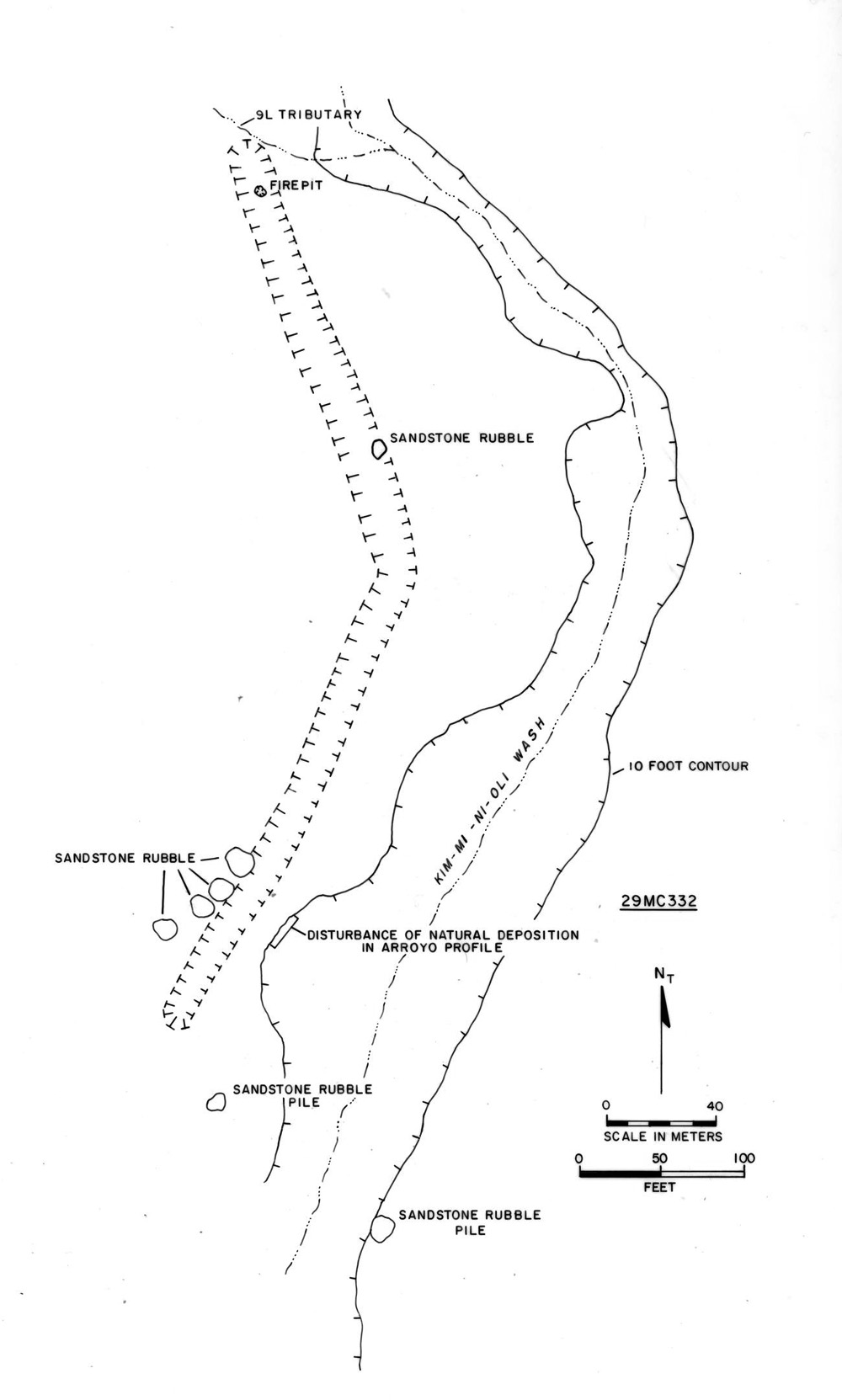 |
Figure 9.8. Plan view of dam and problematic linear feature (29Mc 332) in the Kin Bineola survey area. |
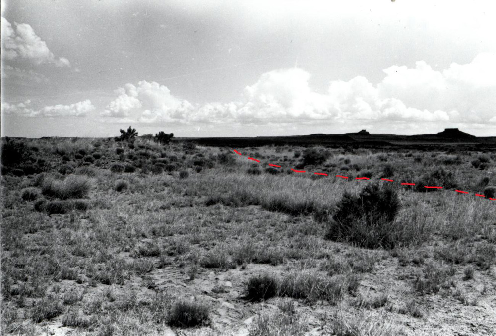 |
Figure 9.9. View of the problematic linear feature at 29Mc 332. Dashed red line shows swale alignment. |
¶ 80 To the northwest of the dam is a large swale which extends north, paralleling the wash along the contour of the west edge of the valley. The swale, shown as a linear concavity in Figure 9.8, is 12 m wide from crest to crest, 1 m deep, and 2-3 m wide at its base. The enclosing berms consist of gravelly residual soil with occasional concentrations of broken bits of sandstone. The berms appear to consist of backdirt removed during excavation. This linear feature extends northward for 300 m before it is intercepted by a western tributary. It is not visible on the other side of the tributary. The swale was originally interpreted as a canal, but when we reexamined the feature, this interpretation seemed unlikely. Although this is clearly a constructed linear feature, it is difficult to see how it functioned to control or deliver water. There is virtually no arable land that could be fed by the canal on the west side of the wash. The east side of the wash is much better suited for this purpose, but the amount of arable land is still quite limited. The berm could not have been built to prevent flood water from rising out of Kim-mi-ni-oli Wash, because the eastward slope of the land would have naturally diverted run-off in that direction. The feature is not perfectly straight, as one might expect it to be if it were a segment of a prehistoric road. It is unlikely that the function of this feature will be resolved without excavation.
¶ 81 A third dam (29Mc 214) is located approximately 1 km to the north. This dam is represented by a mass of rubble in the entrenched Kim-mi-ni-oli drainage bottom and a doglegged earthen berm extending from the south bank of the wash. The rubble is heaped 5 m downstream from where the berm would cross the wash, suggesting that the stone has been shifted by periodic flooding4Gwinn Vivian (personal communication, 2001) believes that the masonry rubble in the wash bottom has not been moved, and “is actually in line with a curve in the earthen berm on both sides of the wash.” . Two additional concentrations of rubble in the wash bottom located 10 and 50 m upstream may represent the remains of other dams. The earthen berm is 5 m wide, 25 to 50 cm high, and 90 m long. Marshall et al. (1979:67) previously described this feature as extending for 125 m–a measurement that may be based on aerial photographic evidence. On the ground, the feature is less distinct.
¶ 82 This dam was originally discovered by Gwinn Vivian in 1970, who does not mention the berm length, but does describe a head gate at the end of the berm. He thought the head gate was used to feed a ditch or canal extending down the west side of the valley (R. G. Vivian n.d.) Vivian also reports a corresponding berm on the north bank of the arroyo, but no trace of a berm or rubble was visible to the Chaco Additions crew. Aerial photographs of this area do show a faint alignment extending 75-100 m to the northeast. The east limit of this alignment would be a logical take-out for 29Mc 341, described below.
¶ 83 A linear feature (29Mc 341) extends northward for nearly 1 km across the barren flats east of Kim-mi-ni-oli Wash immediately southwest of Kin Bineola. This feature has been variously argued to represent a prehistoric road, a historic road, or a canal segment. It is described by Marshall et al. (1979:67) as 4-6 m wide and 50 cm to 1 m deep. The linear feature is clearly visible from a point about 350 m southwest of the Kin Bineola great house to a point about 240 m north of the 29Mc 214 dam. Unlike the possible canal segments previously described, this feature is perfectly straight and lacks berms. It is more densely vegetated than the surrounding flats for most of its length. It cross-cuts the drainage fields of numerous rivulets, and water from these is captured by the feature, resulting in active erosion of its northern extent. At least portions of the feature were used in this century as a two-track road (Lyons et al. 1972; Marshall et al. 1979:67), but its southern end is close to 29 Mc214 and two other canal segments, and its northern end is close to 29Mc 147, suggesting that it is more likely a canal.
¶ 84 Gwinn Vivian identified two canal segments that were independently relocated by the Chaco Additions Survey. The first of these, 29Mc 259, is located near the southern end of 29Mc 341. This canal consists of a 95 m long swale with a 20 m long compound masonry wall and the remains of a possible head gate. The canal emerges from an eastern tributary to deliver flood water from a side canyon into the main valley. The second canal segment, 29Mc 213, is located 50 m to the north. This 10 m-long rubble alignment probably represents an additional segment of the same canal. This segment is visible about 5 m southeast of the linear feature (29Mc 341) described above and, because it approaches 29Mc 341 at a 45 degree angle, it appears to be a tributary canal. If this inference is correct, this canal would have carried water both from the dam and from the side canyon to fields in the vicinity of Kin Bineola.
¶ 85 A more controversial set of features is located about 600m southwest of the Kin Bineola great house, around the southern foot of a small, isolated sandstone remnant known as Teardrop Mesa. The cluster of features associated with the mesa includes 29Mc 147, a crescent-shaped rubble mound, and 29SJ 2527, a complex and lengthy masonry wall (Figure 9.10). Researchers disagree as to whether these represent part of a water control system or a processional avenue. When the authors revisited the site, Van Dyke felt that the latter explanation seemed more likely, while Powers found fault with both. 29Mc 147 was first described by Holsinger (1901) and consists of a crescent-shaped rubble mound approximately 25 m in diameter with a 12-15 m wide arc. Holsinger referred to the area partially enclosed by the masonry arc as a “natural depression” and concluded it was a reservoir used to feed an irrigation ditch. Gwinn Vivian reached a similar conclusion, calling the arc and depression a “canal intake” which received water from the canal identified at site 29Mc 341.
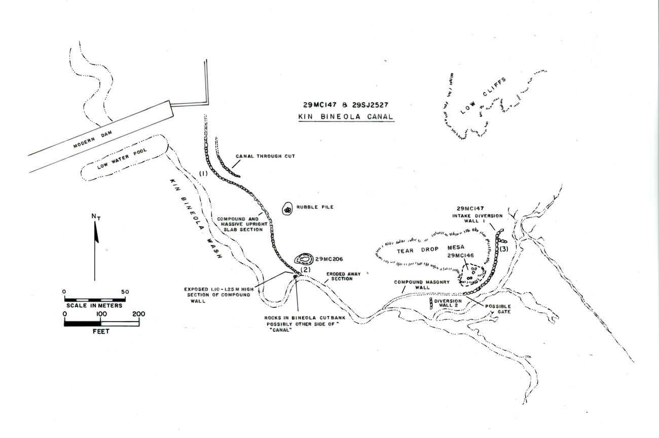 |
Figure 9.10. Plan view of the problematic linear feature ( 29Mc 147 and 29SJ 2527) south and west of Teardrop Mesa in the north portion of the Kin Bineola survey area. |
¶ 86 In 1972 the National Park Service performed a remote sensing study of several anomalous features at Kin Bineola, including this one (Lyons et al. 1972). A test trench excavated through the center of the crescent-shaped mound found a massive core-and-veneer wall 2.5 m wide and 1.5 m high, paved on the top with sandstone slabs. No alluvial deposits were observed on either side of the wall. Stratigraphy for a distance of 28 m to the west and 10 m to the east of the arc was described as undifferentiated aeolian sand with bits of charcoal. This stratum continued below the wall foundation for an unknown depth. Excavation was halted 20 cm below the wall foundation without reaching sterile.
¶ 87 The second feature is a masonry wall extending from the west edge of the crescent along a narrow strip of floodplain between Kim-mi-ni-oli Wash and the foot of Teardrop Mesa (Figure 9.10). Beyond the west tip of the mesa, the wall bends to the north and continues along the east margin of the Kim-mi-ni-oli valley floodplain. Holsinger interpreted the wall as the edge of an irrigation ditch. He claimed it was visible for a distance of two miles (3.2 km), and that the ditch carried water north to a larger tract of arable land in the vicinity of the modern Navajo community of Lake Valley. Today, the wall is intermittently visible for about 800 m before it disappears at the east edge of an earthen dam built by the Bureau of Indian Affairs. The Chaco Additions Survey crew examined the floodplain for 500 m beyond the dam and did not observe any indication of the feature. Additional survey should be undertaken further down the valley to determine if any additional segments are visible. Valley flooding may well have removed portions of the feature since Holsinger’s time.
¶ 88 The Chaco Additions Survey documented this feature for its entire 800 m length. The wall varies in construction from massive core-and-veneer masonry, to massive upright slabs embedded in compound masonry, to residual soil lined with slabs. The wall is broken by at least one opening for a possible “gate” located about 60 m west of the masonry arc. The gate could have channeled water from Teardrop Mesa and a small drainage up slope through to the south side of the wall. On the south side of the wall, opposite the gate, is a diversion wall that may have channeled water from a tributary arroyo or the main wash towards the north. No similar features are present among the remaining span of the wall. Several additional breaks appear to be the result of burial by alluviation, or erosion from Kim-mi-ni-oli Wash.
¶ 89 Gordon Vivian tested three sections of the wall during the 1960s as part of his water control investigations and concluded that the wall was indeed a ditch or canal border (R. G. Vivian n.d.; Figure 9.11). Vivian proposed that during its first 425 m, from the masonry crescent to the point where the wall begins heading to the north, the wall represents the south or downslope edge of a canal. Cross-section 3 in Figure 9.11 provides a profile view of this section of the canal (see (3) in Figure 9.10 for the cross-section location). He suggested that the north canal edge, located higher up slope, was destroyed by flooding or erosion.
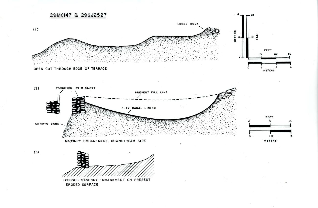 |
Figure 9.11. Cross-sections of the problematic linear feature (29Mc 147 and 29SJ 2527) along Teardrop Mesa, as drawn by Gordon Vivian. See Figure 9.10 for cross-section locations. |
¶ 90 Around the point of the mesa, Gordon Vivian identified two more canal segments, separated from the first canal section by a gap of 120 m where the canal was either buried or washed away. The first of these additional segments was located where a sharp turn in Kim-mi-ni-oli Wash exposed a cross-section of the massive wall (see Figure 9.11, cross-section 2; the location of cross-section 2 is indicated on Figure 9.10 as (2)). Starting at the 1 m wide, 1.3 m high exposed core-and-veneer wall, Vivian excavated a trench up slope through the presumed canal bed. He exposed a swale 9.75 m wide and a berm 1.5 m high that constituted the opposite edge of the linear segment. The bed of the feature had been excavated into sand. It was concave in cross-section and sloped to a mid-point lower than the base of the masonry wall. The up slope side of the feature was formed by a gradual rise and an alignment of rocks, some of which were naturally rather than culturally positioned. The bed contained a thin clay layer which Vivian concluded was the result of natural deposition rather than intentional placement. From the point of this cross-section, the southern masonry wall was visible for another 20 m to the north before disappearing, then reappearing as a row of massive, upright, protruding slabs.
¶ 91 The last and northernmost segment of the 29SJ 2527 wall was excavated through a gravel terrace in a manner similar to 29Mc 332 in the southern portion of the survey area. Here, the feature consists of high west and east berms and an intervening swale. Based on another cross-section excavated by Gordon Vivian (Figure 9.11, cross-section 1; see (1) on Figure 9.10 for the location of this cross-section), the berms are composed of gravel substrate thrown up during the excavation of the swale (R.G. Vivian n.d.). The cross-section measures 18 m from berm crest to crest, with a maximum depth of 1.4 m. Vivian does not describe the nature of the fill but does comment that no clay lining was present.
¶ 92 Vivian’s identification of the masonry arc, wall segments, and swale as parts of a canal system were challenged by Tom Lyons (Lyons et al. 1972) after he excavated several additional cross-sections of the canal in 1972. Lyons re-exposed the massive wall butt, tested an upright slab portion of the wall to the north, excavated a cross-section across a coursed masonry section, and placed a trench across the terrace section of the “canal.” At each of these locations, Lyons noted the absence of water-lain deposits. The fill in all instances is described as aeolian sand. Lyons found no canal channel in the upright slab and coursed masonry test areas. The lack of alluvial fill, the differences in wall construction over the length of the feature, and elevational irregularities led Lyons to conclude that these features did not represent a water control system. This opinion was reiterated by Marshall et al. (1979:67-68) who renamed the canal “Avenida Kin Bineola” and suggested that portions of it represent a prehistoric road.
¶ 93 Upon visiting the site in 2001, Van Dyke expressed agreement with Lyons and Marshall, considering a processional avenue to be a more logical explanation for the feature. Powers, however thought that neither the canal or prehistoric road interpretations were entirely convincing. He pointed out two problems with Vivian’s canal explanation: 1) there is no convincing canal channel for those portions of the system south of Teardrop Mesa, and; 2) the lack of alluvial deposits in the excavated cross-sections. One possible solution to the first problem is that Vivian’s south wall is actually the north wall of the canal, and Vivian’s swale is actually an unintentional byproduct of north wall construction. This would better explain the gate and diversion wall found by the Chaco Additions Survey, which could then be seen as directing water into the canal, rather than letting it escape or channeling it in the wrong direction. He suggests that if this interpretation is correct, much of the canal along the south edge of Teardrop Mesa has been removed by shifts in Kim-mi-ni-oli Wash over the past millennium5Gwinn Vivian (personal communication, 2001) reiterates that the masonry wall along the south side of Teardrop Mesa was on the downslope side of the canal, and that the upslope side of the canal was probably cut into the mesa talus. He also points out that the canal was not receiving water from the wash put rather from the linear feature (29Mc 341).. It is only in the sections beyond the tip of Teardrop, some distance from the wash, that two walls and a canal bed are preserved. The lack of alluvial deposits in the cross-sections excavated west of Teardrop is mystifying, but Powers argues that none of Lyon’s trenches demonstrably cross the canal, and two were so shallow that they could not be expected to display alluvial canal deposits. Unfortunately, none of Lyon’s cross-sections were profiled, photographed close-up, or examined by a geomorphologist, and provenience descriptions are too vague for definite relocation.
¶ 94 Powers suggests that possible irregularities in the canal grade may be explained by the fact that some sections examined are actually outside the canal and no elevations have been taken from the canal cross-section bottoms. It is clear that the base of the masonry crescent is 0.6-1.2 m higher than the canal bottom in the terrace 0.8 km to the northwest. Whether the grade is uniformly downhill in the interim distance cannot be established without excavation and instrument measurement. Excavation might also help clarify the significance of the varying construction styles along the wall. The core-and-veneer masonry, compound and simple coursed masonry, and upright slab sections of the wall may reflect temporal variation, or different portions of the wall may have been built to withstand different stresses. Presuming that the current location of Kim-mi-ni-oli Wash immediately south of the canal is close to its prehistoric position, the massive wall and crescent may have been built to withstand monsoon flooding.
¶ 95 It should be emphasized that the massiveness, width, and curvature of the walls do not fit with known characteristics of other road segments in Chaco and the San Juan Basin (Vivian 1997). Given the size and complexity of the Teardrop Mesa system, the poor surface visibility, and the possibility that much of the system has been destroyed by flooding, small, isolated test trenches of the type excavated by Vivian and Lyons are unlikely to resolve the questions surrounding these features. More extensive and careful excavation is needed to resolve the controversy and discern the function(s) of this problematic set of features.
Chacra Mesa and the South Addition
¶ 96 Check dams are the only water control features found on Chacra Mesa and the South Addition. There are over 20 check dams on Chacra Mesa. Spanning small drainages, the dams range from 1 to 10 m in length and consist of one to four courses of rough slabs stacked up to 1 m in height. Some may have collected water for domestic purposes. Others, on steep upper drainages in sandy soils, were probably constructed to slow run-off and trap soil. Many occur in sequence along small drainages and appear to have formed series of small terraces.
Other Component Types
¶ 97 Sherd scatters are common within the Chaco Additions Survey area (n=50) (Table 2.12). Trails were associated with four of the 50 sherd scatters recorded. Slab scatters and sherd concentrations were the features most frequently associated with sherd and lithic scatters. Hearths (n = 16) and baking pits (n = 69) were usually associated with other hearths, baking pits, or fire-cracked rock concentrations in clusters of two or three features per component. Artifact scatters with slabs (n = 44) and artifact scatters with hearths (n = 89) were frequently associated with slab or fire-cracked rock concentrations (n = 218), hearths (n = 49) and baking pits (n = 22). A total of 18 cist/storage components, 76 rock art components, 23 trails, and 9 shrines were also recorded (Table 2.12).
Settlement Patterns
¶ 98 Land use is quite different across the Kin Klizhin, Kin Bineola, and Chacra Mesa areas. The South Addition is difficult to characterize because of its small size, but land use there generally seems similar to Kin Klizhin. In the following discussion we refer to settlement pattern maps presented by Sebastian and Altschul (Chapter 2). While these also show components dated to composite date groups they nonetheless present a good snap-shot of settlement trends.
Kin Klizhin
¶ 99 There was little Anasazi occupation within the Kin Klizhin survey area between A.D. 550-750 (DG 100)—only two habitations and four artifact scatters are documented (Figure 2.12). From A.D. 700-800 (DG 200), occupation increased slightly (Figure 2.13). Three separate areas with one or more clusters of habitation components are documented in the south, central, and northern portions of the survey unit. Field houses were also in use during this period. Between A.D. 890-1025 (DG 300), the northern habitation cluster was abandoned, but habitation continued in the central area and expanded in the south (Figure 2.14). The A.D. 1030-1130 period (DG 400) witnessed a dramatic increase in the number of habitations and field houses in all areas (Figure 2.15). The Kin Klizhin great house was constructed, and population reached its zenith during this interval (Tables 2.32 and 2.33). This is the only time period during which a substantial number of fieldhouses and artifact scatters occur west of Kin Klizhin Wash. During the A.D. 1130-1230 period (DG 500), the northern part of the Kin Klizhin area was abandoned except for two habitations, a fieldhouse, and two artifact scatters (Figure 2.16). The great house and the area surrounding it was vacated. A small number of habitations and a few fieldhouses remained in the south part of the area.
¶ 100 Water control features are distributed from north to south, but the dated components are limited to the A.D. 890-1130 time span (Figures 2.14 and 2.15). In general water control features are situated almost exclusively along tributaries entering Kin Klizhin Wash from the east (Figure 2.17). Baking pits and hearths (of Anasazi, Archaic and Unknown cultural affiliation) are also associated with the eastern tributaries and upland areas (Figure 2.18). The large masonry dam and spillway, and three canal segments, are the only irrigation features present in the main wash.
¶ 101 Overall, half the Kin Klizhin components and 65 percent of the habitations are located in the agriculturally poor uplands (including sandstone, shale and badland outcrops) (Table 2.25). By contrast, the dissected lowlands contain the best agricultural land but only 13 percent of the habitations. Additional habitations and field houses, if they existed in the lowlands, are probably buried. In an examination of individual site locations Sebastian and Altschul found that nearly all habitations, fieldhouses, and artifact scatters with features are situated on the edges of elevated topography directly overlooking lowland areas where agricultural fields were probably located.
¶ 102 Although a majority of sites are in the uplands, Sebastian and Altschul also discovered that site locations do shift over time at Kin Klizhin. A total of 10 out of 11 habitation sites occupied between A.D. 500 and 1030 are in upland settings, whereas only 4 of 11 habitation sites dated between A.D. 1030-1130 are in elevated locations. The same trend, but slightly weaker, is apparent for fieldhouse locations. By the A.D. 1030-1130 period desirable upland locations may have been already claimed, and in order to maintain settlement near agricultural areas, lowland locations had to be used as well.
¶ 103 Habitations outnumber fieldhouses 3:2 prior to A.D. 1030, but between A.D. 1030-1130 fieldhouses outnumber habitations 2:1. Habitations are spread evenly across the Kin Klizhin area with interspersed fieldhouses. The presence of 4-5 fieldhouses in the vicinity of some habitations suggests multiple fields, or the use and exhaustion of successive fields while the habitation was occupied.
Kin Bineola
¶ 104 During the A.D. 550-750 (DG 100) period, habitations and artifact scatters are thinly spread across the Kin Bineola area (Figure 2.20). Most are found on mesa tops and valley slopes on the east margin of Kim-mi-ni-oli Wash. By A.D. 700-800 (DG 200), there are three distinct clusters of habitations: one in the northwest, a second in the upper center, and a third in the south around the 29Mc 261 great kiva (Figure 2.21). Settlement on the west side of the wash is limited and scattered. Between A.D. 890 and 1025 (DG 300), the Kin Bineola great house was built east of the north cluster of habitations (Figure 2.22). Despite construction of the great house, the northern and central clusters contain fewer, more scattered habitations during this period. The southern group retains its size and it spreads over a slightly larger area, but the 29Mc 261 great kiva is abandoned by the end of this period. During the A.D. 1030-1130 period (DG 400), the number of sites continues to increase (Figure 2.23). The north and upper central clusters are still recognizable, but the south cluster has split into small north and south groups and a larger west group. The west group is the first settlement cluster of any significance to be located on the west side of the wash. The original great kiva locus is completely abandoned by this time. By the A.D. 1130 and 1230 (DG 500) time period the Kin Bineola area is nearly completely abandoned (Figure 2.24). Only one habitation and ledgeroom near the great house, and one fieldhouse in the southern cluster, are present.
¶ 105 As described earlier, several probable and possible water control features are found along the main wash (Figure 2.25). These include three dams, four features identified as swales or possible canals, and a linear feature that has been variously interpreted as a canal or road feature. In association with Teardrop Mesa is a crescent shaped rubble mound that may have functioned as a settling pond and/or canal intake in addition to several segments of a massive wall that may have formed either a canal or a processional pathway. These features cannot be assigned to a specific time period but probably were in use during the most intense period of Kin Bineola occupation between A.D. 1030-1130 (DG 400). Baking pits and hearths of Anasazi and Unknown cultural affiliation are found most frequently in the southern half of the survey area (Figure 2.26). Rock art and shrine components frequently appear in association with one another (Figure 2.27). Ledgerooms are more common (Table 2.12), and are larger (Table 2.13) at Kin Bineola as compared with the other survey areas.
¶ 106 In contrast with Kin Klizhin, the proportional distribution of all sites in the Kin Bineola survey area follows the relative proportions of the major land units; 30 percent of the components are in the uplands (Table 2.27) which comprise 26 percent of the survey area (Table 3.1), and 41 percent are in the dissected lowlands which comprise 43 percent of the survey area. As at Kin Klizhin, most of the habitations are found in the uplands prior to A.D. 1030, with other components heavily represented in the lowlands. After A.D. 1030, this trend reverses. Fewer habitations are found in the uplands and more are found in the lowlands. Valley bottoms were used for habitations only at the peak of settlement, again perhaps because the more desirable upland areas were claimed. Sandstone and shale outcrops and valley slopes were also common locations for a variety of site types over time.
¶ 107 Sebastian and Altschul suggest that the relationship between habitation and fieldhouse components at Kin Bineola differs from that observed at Kin Klizhin, where fieldhouses outnumber habitations 2:1 between A.D. 1030-1130. At Kin Bineola during the same period, habitations outnumber fieldhouses 3:1. One possible explanation is that reliance on major water control systems at Kin Bineola allowed larger fields and closer habitation, thereby eliminating the need for many fieldhouses. However, there is substantial number of ledgerooms in the Kin Bineola area during the A.D. 1030-1130 time period, and if, as suggested elsewhere in Sebastian and Altschul’s study, fieldhouses and ledgerooms served similar functions, ledgerooms may indicate continued use of dispersed agricultural locations (see Figure 2.23). When A.D. 1030-1130 fieldhouses and ledgerooms are combined, the ratio of habitations to fieldhouses is a more substantial 1:0.96The ratio presented is drawn from Sebastian and Altschul’s Appendix 2.1 which shows a total of 19 A.D. 1030-1130 (DG 400) habitations, 6 fieldhouses, and 11 ledgerooms at Kin Bineola., suggesting that field structures were an important part of the settlement system at Kin Bineola, albeit proportionately half as common than they are at Kin Klizhin.
Chacra Mesa
¶ 108 Settlement on Chacra Mesa differs markedly from that described for the Kin Klizhin and Kin Bineola survey areas. Most of the A.D. 550-750 occupation is on Chacra Mesa (Table 2.20), and correspondingly, more pithouses are found here than in the other areas. Rock art, trails, stairs, baking pits, and hearths are all more common than in other areas (Table 2.12). These features fit with the rugged sandstone bench and cliff topography and woodland resources (juniper, yucca, pinyon, rice grass) found on Chacra Mesa.
¶ 109 On Chacra Mesa, between A.D. 550-750 (DG 100), habitations are concentrated on the upper slopes of a long finger mesa on the northeast flank of the survey area (Figure 2.28). The cluster of components forms a substantial community dominated by the very large Basketmaker III village of Shabik’eshchee (29SJ 1659). Shabik’eshchee Village is on the tip of the finger mesa overlooking Chaco Wash. Two other small habitations clusters are located respectively on the dune-covered top of Chacra Mesa and on the ridge tips at the southern foot of Chacra Mesa. Hearth, baking pit, and artifact scatter sites are widely distributed on the mesa top.
¶ 110 Occupation declines during the A.D. 700-880 period (DG 200) (Figure 2.29). There is only one habitation, located on the canyon floor east of Shabik’eshchee and a scattering of nonresidential sites on the mesa top. During the AD. 890-1025 period (DG 300), nonresidential use of the mesa top increases, as indicated by a broad scattering of baking pits, hearths, and artifact scatters (Figure 2.30). Many of these are found along a finger mesa and drainage just west of Shabik’eshchee. There are only two habitations recorded on the Chacra Mesa area during this time. The building preceding the never-finished Chacoan structure (29SJ 2384) may have been established during this period.
¶ 111 Special use sites continue to dominate Chacra Mesa through the remaining two time periods. Between A.D. 1030-1130 (DG 400), there are some habitations clustered along the base of the mesa between the mouths of two northeastern canyons (Figure 2.31). The great kiva 29SJ 2557 was in use during this time and the Chacoan structure, 29SJ 2384 may have been under construction. There are also a few fieldhouses, ledgerooms, and habitations on the mesa top. Fieldhouses, ledgerooms, and artifact scatters are found near the heads of mesa top drainages, often near undated check dams. These areas might have been seasonally farmed by families living elsewhere. Baking pit and scatter with hearth/slab components are slightly more numerous than in the preceding period and are distributed along the mesa top and the upper bench slopes of the mesa . The central finger mesa so heavily utilized during preceding period is virtually abandoned.
¶ 112 Between 1130-1230 (DG 500), as in the other survey areas, Chacra Mesa was virtually abandoned (Figure 2.32). Only a single, large, defensive habitation (29SJ 2606) and the isolated great kiva (29SJ 2384) remain to preside over a few scattered baking pits, hearths, fieldhouses, ledgerooms, and artifact scatters.
¶ 113 Check dams of both Anasazi and Unknown cultural affiliation are consistently located at the heads of the north slope drainages, particularly in the western half of the survey area (Figure 2.33). Some of these are adjacent to fieldhouses and ledgerooms dating from A.D. 1030-1130 (DG 400) (Figure 2.31). Some may also be associated with Navajo sites. An examination of the distribution of hearths and baking pits of Anasazi and Unknown cultural affiliation shows that they are broadly and evenly spread across the entire Chacra Mesa survey area (Figure 2.34). The large number of baking pits and hearths is almost certainly related both to the abundance of resources being processed and/or eaten, and the widespread availability of firewood. Rock art panels are concentrated in the northeast corner of the survey area adjacent to the early and late centers of habitation (Figure 2.35). A few panels are also located along the upper benches of the north flank of the mesa. Rock art and trails are commonly associated, and many panels are found along the trails and stairways that scale the sandstone cliffs and narrow benches forming the south face of the mesa.
¶ 114 Six environmental zones on Chacra Mesa account for 82 percent of the land area (Table 3.1) and the locations of 90 percent of the Anasazi components (Table 2.29). Benches on the wooded northeast escarpment of Chacra Mesa comprise 37 percent of the survey area . This area contains 52 percent of the recorded components, including 67 percent of the baking pits, 72 percent of the ceramic scatters, and 96 percent of the water control features.
¶ 115 The environmental locations of most component types do not change over time, with the notable exceptions of baking pits and habitations. Baking pits are found increasingly on benches over time, and habitations are found primarily on benches in A.D. 550-750 (DG 100). Habitation locations are difficult to characterize due to small numbers between A.D. 700-1025 (DG 200 and 300), but concentrate in upland, lowland, slope, and outcrop settings between A.D. 1030-1130 (DG 400) (Figure 2.31). None of the various latter locations are on benches; most are in talus or low prominences adjacent to arable soils. This shift appears to reflect a desire to locate habitations closer to field areas. Hayes (1981:23-24) documented the same shift in settlement for Chaco Canyon as a whole. Although Basketmaker III sites are present on mesa tops, Pueblo I and later period habitations are rarely found there. As at Kin Klizhin and Kin Bineola, it appears to have been important to place habitations near arable land, but without actually situating them in the floodplain.
South Addition
¶ 116 Because of its small size, substantive treatment of settlement patterns within the South Addition is difficult. A few habitations are present in the A.D. 550-750 (DG 100) and A.D. 700-880 (DG 200) periods on low ridges and valley slopes below the South Mesa escarpment (Figures 2.36 and 2.37). The same distribution is apparent during the A.D. 890-1025 (DG 300) interval, but with slightly more habitations, fieldhouses, and artifact scatters (Figure 2.38). The number of sites is reduced by the A.D. 1030-1130 (DG 400) period (Figure 2.39), and the area is entirely abandoned by A.D. 1130. A few check dams, baking pits, and hearths are scattered among cliff talus, ridge top, and valley slope areas. Rock art panels, trails, hearths, baking pits and water control components of both Anasazi and Unknown cultural affiliation are scattered across the survey area (Figure 2.40).
¶ 117 Generally, the proportional distribution of the South Addition sites does not reflect the proportions of the environmental zones defined in the South Addition survey area (Tables 2.30 and Table 3.1). Some of this disagreement is likely a product of the small size of the survey area and the relatively small number of sites. The zone containing badlands with dissected hills and thin soils is the exception, accounting for about one-third of the land area and one-third of the components. It also contains somewhat less than one-third of the habitations. Approximately 20 percent of the components are in the mesa outcrop-talus zone (13 percent of the survey area), and unsurprisingly, 40 percent of these are rock art panels. Lowlands and drainages with fair and good agricultural potential account for 31 percent of the area, but only about 23 percent of the components, although half of the fieldhouses, sherd and lithic scatters, and scatter with slab components are found here. Temporal trends are difficult to trace, but habitation sites do generally seem to shift from slightly higher badlands and dissected hills to lowland drainages, moving closer to agricultural land through time.
Settlement Summary
¶ 118 The temporal histories of settlement in each of the four survey areas are similar to each other and to Chaco Canyon (Hayes 1981: 23-32), with settlement generally increasing over time. In Chaco Canyon, settlement as measured in numbers of sites peaks around A.D. 975, decreases slightly to about A.D.1175, then drops sharply. This pattern is largely duplicated in the Chaco Additions Survey areas prior to A.D. 975, but unlike Chaco Canyon, the number of sites in the Chaco Additions survey areas continues to grow up to the end of the A.D. 1030-1130 (DG 400) period (Table 2.20). Deviations from this pattern are seen at Chacra Mesa and in the South Addition during the A.D. 700-880 (DG 200) interval, where settlement drops from the preceding A.D. 550-750 (DG 100) interval, then recovers during the A.D. 890-1025 (DG 300) period. Settlement in the South Addition peaks between A.D. 890-1025 (DG 300) congruent with settlement in the canyon. Given the South Addition’s location on the perimeter of the canyon, this is not surprising.
¶ 119 The continuing growth in the number of sites at Kin Klizhin, Kin Bineola, and Chacra Mesa may reflect population saturation in the canyon itself. People may have been moving out of Chaco Canyon, or moving in from other areas and settling on its peripheries, or both. When settlement in Chaco Canyon declines around A.D. 1150-1175 (or slightly earlier), settlement in all four survey areas drops much more sharply. It appears that events in the canyon had a substantial impact on habitation in the additions areas.
¶ 120 Agriculture was a major focus of the Kin Klizhin and Kin Bineola communities as well as the South Addition. Chacra Mesa was used heavily for specialized resource extraction. These activities are represented by the types and locations of components in the different areas. Early pithouse habitations are often in sandy upland locations, as at Kin Klizhin, Kin Bineola and on Chacra Mesa. Between A.D. 700-1025 (DG 200 and 300), habitations are in upland locations adjacent to lowland floodplains. Habitation locations appear to have been selected for security from flooding coupled with proximity to agricultural fields. Lowland habitations post-dating A.D. 1030 tend to be situated on slight rises or bedrock outcrops. Building stone appears to have been another factor in habitation location, as indicated by the notable lack of habitations on the west sides of the Kin Bineola and the Kin Klizhin survey areas, where fewer sandstone exposures are present. Maintenance of a residence close to fields, either to tend crops, to protect use rights, or both, appears to have been essential. The increasing number of fieldhouses over time (Table 2.15) suggests that new structures were built as fields were fallowed or abandoned, or that an increasing number of field areas were farmed. It is worth noting that habitation locations are not positively correlated with Chacoan structures at either Kin Klizhin or Kin Bineola. Although the locations where Chacoan structures were ultimately built never seem to have been desired habitation locations, the mean distances between these locations and habitations actually increased once Chacoan structures were constructed (Tables 2.26 and 2.28).
¶ 121 Chacra Mesa was used intensively for a variety of purposes by people who lived in Chaco Canyon and along Fajada Wash. Except for the A.D. 550-750 (DG100) and 1030-1130 (DG 400) periods relatively few Anasazi habitations were present. During the latter period an unfinished Chacoan structure, a great kiva, and a cluster of habitation components are scattered along the lower mesa slopes and canyon bottom. present. Artifact scatters, baking pits, hearths, and combinations of these features are common on the mesa during every time period. Baking pits appear to be increasingly concentrated on the northeastern escarpment over time, although whether this trend is real or not is difficult to evaluate given the large number of undated baking pits. Otherwise, distribution of features is consistent from period to period. The absence of architecture and substantial refuse at special use components on the northeast mesa flank, coupled with the almost continuous distribution of features and artifacts on the sandy mesa top, suggests short-term use of Chacra Mesa over long periods of time.
¶ 122 The features and artifacts at many of these sites suggest their use as short-term camps, but the specific activities performed are more difficult to identify. Modern physiography and vegetation provide some clues. Many of the hearth and artifact scatter with slab/hearth components on the mesa top are in dune and blowout areas which today support numerous grasses and spring annuals. These components may represent seasonal camps used for gathering seeds and greens. Sporobolus airiodes (sand dropseed) and Oryzopsis hymenoides (Indian rice grass) are abundant here, and these plants were important components of the Puebloan diet during all time periods. Purslane, mustard, spurge, and stickleaf are also present on the mesa top and were frequently recovered from canyon sites (M. S. Toll 1985:247-254). Narrow-leaf yucca (Yucca spp.) is also widespread on Chacra Mesa and was observed both in the dune grasslands on the mesa top and in the pinyon-juniper woodland areas blanketing the northeast mesa escarpment. Its frequency here is in contrast to lower elevation areas of Chaco Canyon where Toll (1985:254) describes it as “not common.” Although yucca seeds, cordage and sandals have been recovered from a handful of excavated sites in the lower Canyon, there is no physical evidence of the caudex or roots (widely used for soap). Moreover, there is no clear relationship with any feature type (such as hearths or heating pits) and yucca macrobotanical or pollen remains (Toll 1985: 254).
¶ 123 Some of the hearths, artifact scatters, and baking pits on the northeast escarpment of Chacra Mesa probably include the remains of pinyon-gathering camps. If pinyon trees were more widely distributed prehistorically, some of the baking pits may have been used to roast pinyon nuts during the fall harvest. Other food items may also have been brought to the mesa top for roasting or baking because of the abundance of wood there, a prospect that suggests the pits might have been used for baking a variety of foods. A final possibility is that some of the baking pit and hearth sites may have been pottery kilns. Although Chaco Canyon sites have produced very modest evidence of pottery production, particularly after A.D. 900 (Toll and McKenna 1997: 156-161) some Chacra Mesa hearth and baking pit sites predate A.D. 900, and many others, without surface ceramics, are of unknown date. The relatively small size of most of these features suggests that if they are kilns, they are not of the trench type, but resemble the Puebloan circular to ovoid pit kilns described by Lakatos (1996) in the Santa Fe area.
Ceramic and Lithic Data
¶ 124 Anasazi ceramics account for 96 percent (n = 73,894) of the sherds recorded by the survey (Table 4.2); the remainder are of Navajo or historic Pueblo manufacture or use. Three-quarters (n = 19,077; 75 percent) of the lithics recorded were found at Anasazi sites and are of presumed Anasazi manufacture (Table 5.1). Data from a total of 77,323 ceramic artifacts from 709 sites were analyzed by Mills. Cameron and Young examined 25,515 lithic artifacts from 569 sites and 951 proveniences. Over 90 percent of the lithic artifacts were chipped stone.
¶ 125 These data were used to address several issues in the preceding chapters. The ceramic and lithic data collected by the Chaco Additions Survey constitutes a large body of artifactual evidence from outlier communities useful for the examination of production and distribution. Ceramic and lithic functional and technological variation were investigated. Ceramics and lithics also were employed to evaluate the site typology in accordance with the original research goals as outlined in Chapter 1. Major patterns and trends identified by Mills and Cameron and Young are summarized here. Interpretations are discussed in the synthetic section, “Great House Communities in the Chaco Additions,” below.
Ceramic Wares and Locations of Production
¶ 126 Most Anasazi ceramics examined by Mills (see Chapter 4) were classifiable at least to the ware level. Wares present include Cibola Gray Ware, Cibola White Ware, Chuska Gray Ware, Chuska White Ware, Mesa Verde White Ware, Tusayan White Ware, San Juan Red Ware, White Mountain Red Ware, and Tsegi Orange Ware (Table 4.19). Cibola White Ware and Cibola Gray Ware account for nearly 90 percent of all ceramics examined. Cibola White Ware and Cibola Gray Ware are not currently traceable to specific manufacturing areas, because they were made with buff-firing clays and sherd, sand, and sandstone tempers that occur widely throughout the San Juan Basin. Given the large size of the area over which Cibola wares are distributed, many of the Chaco Canyon Cibola wares (and probably Chaco Additions Survey Cibola wares) were probably not made locally (H. W. Toll et al. 1980:97). Unfortunately, in the absence of more sophisticated material sourcing analyses, it is impossible to make more specific determinations with regard to these wares.
¶ 127 Chuska White Ware and Chuska Gray Ware account for slightly less than 8 percent of the Chaco Additions Survey ceramics. Sourcing is less problematic for these wares because of their distinctive trachyte temper and red-firing clay (Garrett and Franklin 1983; Judd 1954; Loose 1977; Shepard 1939; Warren 1967; Windes 1977). Trachyte is found only in the Chuska Valley, and red-firing clays are limited to the Chuska Valley and the northern drainages of the San Juan River. Recent work by Mills et al. (1997) indicates a Narbona (Washington) Pass outcrop is a likely source for the temper, and suggests that Chuskan wares may have been produced at Skunk Springs. Because the best sourcing information is available for Chuskan wares, these sherds offer the best opportunity to study ceramic movement in the Chaco Additions Survey communities.
¶ 128 Mesa Verde White Ware accounts for 1 percent of the Chaco Additions Survey ceramics. This ware is characterized by red-firing clay and andesite-diorite temper. Both attributes indicate the ware was produced in a broad area north of the San Juan River. The other imported wares recovered by the Chaco Additions Survey are even less frequent and are assumed to have been produced in the areas where they are ubiquitous. Tusayan White Ware and Tsegi Orange Ware originate in northeast Arizona and southeast Utah. White Mountain Red Ware is made in east-central Arizona and west-central New Mexico.
¶ 129 Because vessel form is generally accepted as a good indicator of vessel function, the proportions of forms within a ware class are a good indication of the purposes for which the vessels were intended. From these premises, it is possible to evaluate whether a ware is functionally specific. It is also possible to evaluate whether selected forms of a ware were being imported. Both of these aspects of ceramic production and distribution were examined by Mills using the Chaco Additions Survey data.
¶ 130 The Chaco Additions Survey assemblages exhibit an overall bowl to jar ratio of 1:6, but a nonlocal bowl to jar ratio of 1:3, indicating that more bowls than jars were being brought in (Table 4.26). Twenty-one percent of all bowls are imports, while only 9 percent of all jars are. Although Cibola White Ware was made in both bowl and jar forms, jars increase proportionately through time (Table 4.20). Perhaps because of this, bowls increasingly dominate Chuska White Ware, White Mountain Red Ware, and Tsegi Orange Ware imports over time. These latter two wares were imported from greater distances than Chuskan wares, suggesting that bowl forms were preferred for long-distance transport. Bowls are smaller, lighter, and can be nested.
¶ 131 As in Chaco Canyon, Chuska White Ware and Chuska Gray Ware account for most of the imported jars (5,234 of 5,807 [90 percent] imported jars; see Tables 4.19, 4.21 and 4.26). Despite the difficulties of transport, Chuska jars may have been valued because of some functional attribute, such as greater durability (Windes 1977) or strength (Neupert 1994), or it may have been the jars’ contents that were important.
Lithic Materials and Sources
¶ 132 A wide variety of chipped and ground lithic materials were found in the Chaco Additions Survey areas. For purposes of analysis, Cameron and Young (see Chapter 5) combined these into ten categories of local materials and six categories of nonlocal or imported materials (Table 5.16). Most (94 percent) of the lithic assemblage is made from local material types. Most of the local woods, cherts, and chalcedonies occur in the Ojo Alamo, Kirtland, Fruitland, and San Jose Formations north of Chaco (Figure 5.1). Sandstone is from the Cliffhouse Sandstone Formation which forms the walls of Chaco Canyon, while baked shale, hematite, selenite, and calcite are available throughout the Chaco Canyon area. Cherts, chalcedonies, and woods are also ubiquitous in redeposited gravel deposits throughout the Chaco Canyon and Chaco Additions Survey areas.
¶ 133 Although there are relatively few nonlocal lithics present, most were probably imported from distances of 50 km or farther. Imported lithic types include: Morrison Formation cherts and quartzitic sandstones (1 percent), yellow-brown spotted chert (2 percent), Narbona Pass chert (1.6 percent), Zuni wood (0.4 percent), Laguna chert (0.3 percent), and obsidian (1.3 percent)(Table 5.16). Morrison Formation cherts and quartzitic sandstones appear in outcrops around the perimeters of the San Juan Basin, although usable deposits are thought to occur only in the Four Corners area. Yellow-brown spotted chert outcrops are reported from the east edge of the Zuni Mountains 80 km southeast of the survey areas. Narbona (Washington) Pass chert comes from Narbona Pass in the Chuska Mountains 80 km west of Chaco Canyon, but it may also occur in streambed gravels in the Chuska Valley. Zuni wood originates in Triassic deposits in the Zuni area 140 km away but has not been pinpointed to a specific source. Laguna chert is found in the upper Morrison Formation near Laguna, New Mexico. Obsidian recorded by the survey could not be identified to a specific source in the field, but excavated obsidian in Chaco Canyon comes from as many as a dozen sources. Jemez (Jemez Mountains) and Red Hill (Mogollon Mountains) are the most common sources for obsidian recovered from excavated sites in Chaco Canyon (Cameron and Sappington 1984). The nearest source for obsidian is Grants Ridge, 100 km to the south.
¶ 134 With respect to tools, over 25 percent of Additions Survey projectile points were made of nonlocal materials, primarily obsidian. Scrapers and bifaces were primarily of local material. As in Chaco Canyon (Cameron 1997: Table 3.23), most drills were made of local materials, with chalcedonic silicified wood most common.
Distribution of Nonlocal Ceramics and Lithics
¶ 135 Nonlocal ceramics and lithics increase through time in all four survey areas. Although locally produced ceramics are dominant through time in all four survey areas, the proportion of imported ceramics steadily increases, from less than 1 percent (South Addition) in the A.D. 550-750 (DG 100) period to 27 percent (Kin Klizhin) in the A.D. 1130-1230 (DG 500) period (Figure 4.5). During four of the five periods Kin Klizhin has the highest proportions of nonlocal wares. The exception is the A.D. 700 to 880 (DG 200) time period when the South Addition has a slightly higher proportion of nonlocal ceramics than Kin Bineola. The proportion of nonlocal ceramics at Kin Bineola peaks at 12 percent between A.D. 1030-1130 (DG 400). At Kin Klizhin and Chacra Mesa, nonlocal ceramic proportions reach highs of 26 to 27 percent between A.D. 1130-1230 (DG 500).
¶ 136 Chuska Gray Wares at Kin Klizhin, Kin Bineola, and Chacra Mesa increase steadily over time, peaking between A.D. 1030-1130 (DG 400) (Figure 4.6). With the exception of the A.D. 550-750 (DG 100) time period, Kin Bineola sites have consistently lower proportions of Chuska Gray Ware ceramics than Kin Klizhin sites, but higher percentages of this ware than the South Addition or Chacra Mesa (although Chacra Mesa has higher percentages during the A.D. 1130-1230 [DG 500] interval) sites. Overall, the Kin Klizhin area contains proportionally more Chuska Gray Ware than the other survey areas.
¶ 137 Frequencies of nonlocal white wares across the Chaco Additions Survey area are temporally bimodal. Kin Klizhin and Kin Bineola have the highest proportions of nonlocal painted ware between A.D. 550-750 (DG 100), with Tusayan White Ware the most common import (Table 4.27). Nonlocal white wares decrease in frequency at the two outlier communities in the next three time periods but surge during A.D. 1130-1230 (DG 500) interval. During the last two periods Mesa Verde White Ware is the dominant import.
¶ 138 As with ceramics, the proportions of imported lithic materials increase steadily over time. Nonlocal lithics account for 6 percent of all lithics in the A.D. 550-750 (DG 100) period, whereas by A.D. 1130-1230 (DG 500) they account for 12 percent (Table 5.18). In marked contrast to all other periods, the proportion of nonlocal materials declines during the A.D. 890-1025 (DG 300) time interval. Excluding the A.D. 890-1025 period, this pattern of increase is repeated when nonlocal debitage and tools are examined (Table 5.72), although in general less nonlocal debitage is present than would be expected if the tools had been manufactured on site. There is an initially high proportion (17 percent) of nonlocal tools during the A.D. 550-750 (DG 100) period, followed by a decrease (12 percent) between A.D. 890-1025 (DG 300), then a resurgence (21 percent) during the A.D. 1030-1130 (DG 400) period. Between A.D. 1130-1230 (DG 500), the proportion of nonlocal tools reaches its zenith of nearly 24 percent.
¶ 139 The occurrence of individual nonlocal materials varies somewhat over time and by area. Chacra Mesa exhibits a high proportion of obsidian between A.D. 550-880 (DG 100 and 200) (Table 5.19). Kin Bineola contains the highest frequency of nonlocal material of the four survey areas, during all time periods, and the dominant nonlocal material in that community is yellow-brown spotted chert. No nonlocal type except yellow-brown spotted chert accounts for more than 6 percent of the lithic assemblage in any area during any time interval, and Narbona Pass chert accounts for no more than 5 percent of any Chaco Additions Survey area assemblage during any time period. These patterns are distinctly different from Chaco Canyon, where Narbona (Washington) Pass chert comprises up to 20 percent of the lithic assemblages at some post-A.D. 1020 sites, and yellow-brown spotted chert is comparatively infrequent.
¶ 140 Proportions of nonlocal ceramics and lithics were compared among Chacoan structures/great kivas, habitations (large structures), and nonresidential sites. The distribution of nonlocal ceramics for great houses, great kivas, and habitation sites is compared for the three areas with Chacoan structures in Figure 9.12 (see also Table 4.28 and Figure 4.9). In the Kin Klizhin area, the great house (29SJ 1413) (20.2 percent) has a higher percentage of nonlocal ceramics than habitation sites (15.5 percent). In the Kin Bineola area, the great house (29SJ 1580) (18.5 percent) yielded nearly twice as many nonlocal ceramics as contemporary habitation sites (10.3 percent). Lower percentages of nonlocal ceramics were recovered from the small great house (29Mc 291) at the south end of the Kin Bineola community (14.3 percent) and the isolated great kiva (6.2 percent). On Chacra Mesa, the isolated great kiva (29SJ 2557) produced a much higher proportion (22.1 percent) of nonlocal ceramics than either the unfinished great house7Because this great house is thought to have never been completed, and because it overlies an earlier site, it is impossible to determine what proportion of the ceramic assemblage is associated with the great house. (29SJ 2384) (12.8 percent) or habitations (9.1 percent). Interestingly, small structures, which were likely used as field houses, had percentages of nonlocal ceramics that exceeded or were comparable to those at habitations. Nonstructural sites, such as hearths, scatters, baking pits, generally had the lowest proportions of nonlocal ceramics.
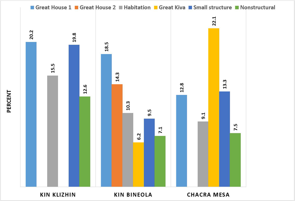 |
Figure 9.12. Percentages of nonlocal ceramics at great houses, great kivas, habitations, small structures, and nonstructural sites (data from Mills, Chapter 4). Great house 1 at Kin Bineola is 29SJ 1580; Great house 2 is 29Mc 291. |
¶ 141 Cameron and Young observed somewhat different proportions of nonlocal lithic materials among great houses, great kivas, habitation (large structure) and non-residential sites across the survey areas (Figure 9.13; see also Table 5.20). Although the proportions of nonlocal lithic materials at Kin Klizhin habitations (7.6 percent), like ceramics, are substantially lower than those at the Kin Klizhin great house (16.1 percent)8Part of the proportional difference between nonlocal materials at habitations and the great house may be a product of the small artifact sample size at the Kin Klizhin great house. A total of 87 lithics were recorded of which 14 are of nonlocal material., the differences in the proportions of nonlocal materials observed between great houses, great kivas, and habitations in the Kin Bineola and Chacra Mesa survey are relatively small, particularly in comparison to the differences for nonlocal ceramics. Small structures and nonstructural sites consistently had the lowest proportions of nonlocal lithics, although the percentages at Kin Bineola were higher than in the other areas.
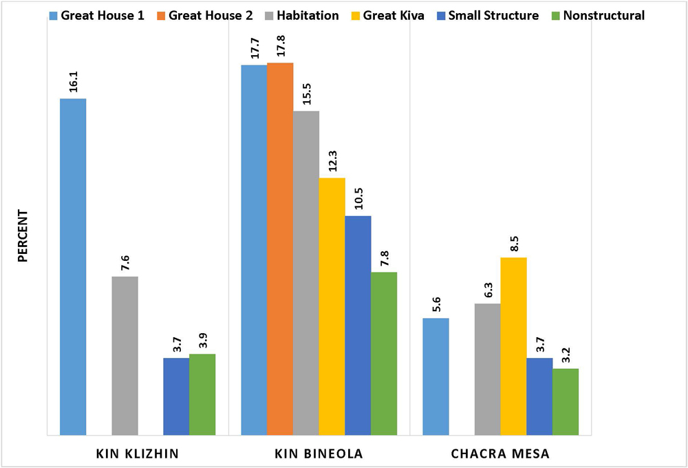 |
Figure 9.13. Percentages of nonlocal lithics at great houses, great kivas, habitations, small structures and nonstructural sites (data from Cameron and Young, Chapter 5). Great house 1 at Kin Bineola is 29SJ 1580; Great house 2 is 29Mc 291. |
¶ 142 Nonlocal ceramic and lithic assemblages from the Kin Klizhin and Kin Bineola communities were compared with assemblages from Chaco Canyon, and distances to source areas were also examined. Because these studies were undertaken to address larger questions about the Chacoan world, results are discussed in the interpretive section, below.
Functional Variation in Ceramic Assemblages
¶ 143 The second objective of the Chaco Additions Survey research design was to employ surface artifacts to identify differences in the function of archaeological sites–in other words, to assess the fit between the site classification typology and artifact assemblages. This objective was addressed by Mills (see Chapter 4) in the context of a broader investigation into functional variation in ceramic assemblages. Mills used two vessel attributes–vessel form and surface treatment–to identify functional characteristics of ceramic assemblages. Sherds were divided into three classes: plainware jars, decorated jars, and decorated bowls. Initially, a univariate analysis was conducted to determine the mean proportions and Coefficients of Variation (CVs) for each ceramic class at each site type (Table 4.34).
¶ 144 Then, in order to further examine the three ceramic classes independent of site type categories, the proportion of each ceramic class at each provenience or feature was calculated. Using a cluster analysis with a 20-cluster limit, the ceramic class proportions of each assemblage was compared to those of all other assemblages in order to generate clusters composed of similar assemblages. Once the clusters had been created, related clusters were combined to form cluster groups (see Table 4.35 and Figure 4.16) which were then compared back to the deposit types, site types, and features to evaluate the degree of correspondence.
¶ 145 Both the univariate and the cluster analyses revealed that there was patterned variability among the ceramic assemblages which appeared to be a result of general patterns in site usage. In the univariate analysis, a number of strong relationships between the three functionally sensitive vessel classes and the site type designations were discovered. Plainware jars dominated the assemblages for nearly all site types (Table 4.34). Structural sites contained higher percentages of decorated bowls and plainware jars, and lower percentages of decorated jars, than nonstructural sites. As measured by coefficients of variation (CV’s) for each vessel class, structural sites had low CVs indicating relatively little assemblage variation within each class, while most non-structural site types had higher CVs.
¶ 146 These general results were amplified in the cluster analysis. When the cluster groups derived by the analysis were compared with deposit types, it was discovered that nearly 80% of the ceramic assemblages from trash mounds were clustered in the B1 group (Table 4.36). The assemblages forming this group had a narrow range of ceramic class proportions (17-28 percent decorated jars; 54-70 percent plain jars; 10-18 decorated bowls). Because the trash mound assemblages are associated exclusively with Chaco structures, great kivas and roomblocks, Mills interpreted these ceramic assemblages as being the product of highly redundant activities associated with habitation. When the cluster group assemblages were examined by site type, the site types of great houses (Chacoan structures) and great kivas were found to show the greatest homogeneity, and therefore, the least ceramic assemblage variability, with most assemblages from these site types falling into the B1 group (Table 4.37). Most habitations (i.e., roomblocks) also fell into the B1 category, although the majority of pithouses were placed in the B2 category which had over 80% plainware jars.
¶ 147 Many of the ceramic assemblages from fieldhouses, ledgerooms, and fieldhouse/water control site types also clustered in the B1 and B2 categories, associated with habitation. There is more assemblage variability amongst fieldhouses (as indicated by higher CVs) however, with more fieldhouses sorting into the A and D groups with lower percentages of plainware jars. Group A assemblages have higher proportions of decorated jars (and lower proportions of plainware jars) and are thought by Mills to be indicative of day use only. Group D assemblages do not have a clear predominance of any ceramic class; although the presence of plain ware jars suggests some cooking activity. Although the majority of ceramic assemblages associated with fieldhouses and ledgerooms are similar to those of habitations, there is substantially greater diversity, some of which, Mills speculates may be related to variation in fieldhouse or ledgeroom size, which ranges from one to two rooms.
¶ 148 In comparison to the structural sites, nonstructural site types had fewer B1 habitation assemblages and greater percentages of assemblages assigned to the A and D groups. The CV values for these assemblages were also much higher indicating greater variability within each class.
¶ 149 Overall, Mills observes that low assemblage variability correlates with high facility investment at great houses, great kivas and habitations. In contrast, high assemblage variability is most frequently associated with low facility investment characteristic of special use sites. Although this pattern is somewhat counterintuitive — since greater assemblage variability might be expected at sites where a greater range of activities probably occurred, and less assemblage variability at limited activity sites where only a few tasks were performed — Mills emphasizes that it is not the range of activities that produces variability, but —differences in the rates of failure (i.e., breakage) of ceramics.— Thus, if the rates of breakage of ceramics are stable, as they probably are for habitation sites, where highly repetitive activities occurred over substantial periods of time, the assemblages produced are less variable.
¶ 150 Conversely, much of the variability observed at structural and nonstructural sites presumably used for short periods may be due to the fact that stability in ceramic proportions takes time to occur even with redundant activities. Because the use lives of different ceramic classes are unequal, the time needed for stabilization will depend on differences in use lives, the periodicity and length of occupation, and in all probability, other factors. Given the variety of potential inputs, Mills concludes that both sites occupied for short durations and sites with different, non-repetitive activities, may have highly variable proportional classes.
Technological and Functional Variation in Lithic Assemblages
¶ 151 Cameron and Young examined lithic technological variability, investigating differences in manufacturing techniques and assemblage composition over time among the survey areas and among site types. The Anasazi lithic assemblage consists of debitage (84 percent), chipped stone tools (10 percent), ground stone (3 percent), minerals (2 percent), and ornaments (0.1 percent) (Tables 5. 31, 5.35, and 5.63). Debitage includes primary and secondary flakes, bifacial thinning flakes, and angular debris. Included within the tool category are formal (projectile points, scrapers, bifaces, and drills; 1.7 percent), informal (utilized and retouched flakes; 4.9 percent) and other (cores, hammerstones, other; 3.7 percent) tools. In addition to cores and hammerstones, the “other” tool category includes a variety of chipped implements such as axes and choppers.
¶ 152 In the Anasazi assemblage as a whole, an average of nearly 13 pieces of debitage are present for every tool (excluding “other” tools), and three informal tools exist for every formal one (Table 5.34). Survey area ratios for debitage to tools are comparable except at Kin Klizhin, where the initial recording procedure resulted in under-representation of informal tools (Tables 5.36-5.39). As a result, the ratio of debitage to informal tools at Kin Klizhin is inaccurate and should be disregarded.
¶ 153 Similarly high debitage to tool ratios for chipped stone materials across the survey areas suggest that most raw material reduction occurred at Anasazi and Archaic sites. The Anasazi 12.8:1 debitage to tool ratio is comparable to the Archaic 12.7:1 ratio (Table 5.34). However, the Anasazi formal to informal tool ratio of 0.35:1 is lower than the Archaic 0.75:1 ratio. The Anasazi assemblage has a slightly lower proportion of bifaces (1.7 percent) and bifacial thinning flakes (1 percent) in comparison with the Archaic assemblage, which exhibits proportions of 2.0 percent and 3.3 percent for these materials, respectively (Tables 5.35 and 5.31). More tellingly, bifacial tools, such as bifaces and projectile points account for over 23 percent of the tool assemblage at Archaic sites while these two tool categories comprise slightly over 8 percent of the Anasazi tool assemblage. Based on the differences in the formal to informal tool ratios and the proportions of bifacial thinning flakes and bifacial tools between Anasazi and Archaic sites, it is clear that Anasazi reduction technology is more oriented toward flake production and informal tools, whereas Archaic reduction technology appears to focus on biface and formal tool production. As indicated by the low informal tool ratio, tool production at Anasazi sites tends to be expedient.
¶ 154 These assemblage characteristics were useful in evaluating the cultural affiliation of the Other/Unknown lithic assemblage of which 95 percent is from Chacra Mesa (Table 5.3). Much of this material was found in “camp-like site” components with large, diffuse scatters in the sand dune and grassland areas atop Chacra Mesa (Table 5.4). These scatters have a debitage to tool ratio (11.8:1) that is slightly higher than both the Anasazi (10.5:1) and Archaic (10.3:1) ratios for Chacra Mesa components only. The formal to informal tool ratio (0.34:1) is slightly higher than that for Chacra Mesa Anasazi components (0.27:1) but substantially lower than that of Chacra Mesa Archaic components (1.18:1) (Table 5.37). The proportion of bifacially worked tools (16.4 percent) is higher than that found at Chacra Mesa Anasazi components (9 percent), but substantially less than that at Chacra Mesa Archaic components (35.3 percent) (Table 5.53), while the proportion of biface thinning flakes (2.3 percent) is intermediate between Anasazi (1.2 percent) and Archaic (4 percent) components (Table 5.33). Because the Other/Unknown values for most of these measures are closer to those of Anasazi components on Chacra Mesa, Cameron and Young argue that the majority of the mesa top camps likely represent the activities of Anasazi hunters and gatherers, although some Archaic components are undoubtedly mixed in.
¶ 155 The proportion of nonlocal materials in the general Anasazi assemblage (8 percent) is higher than that found in the Archaic assemblage (3 percent) (Table 5.71). About 7 percent of the Anasazi debitage and 17 percent of the Anasazi tools are of nonlocal materials. The proportion of nonlocal tools to nonlocal debitage (1:5.5) at Anasazi sites is substantially higher than the proportion of local tools to local debitage (1:14). Because nonlocal debitage is less common, it appears that some initial reduction took place outside the survey areas, perhaps at the raw material source locations. The Kin Klizhin and Kin Bineola areas have nonlocal debitage to tool ratios that are two to three times that of the South Addition and Chacra Mesa, suggesting that more nonlocal reduction and tool manufacture took place at the outliers than in the two peripheral canyon areas (Table 5.75). Angular debris increases markedly over time at Anasazi sites (Table 5.44) and very high proportions of angular debris were documented at Kin Bineola (71 percent) (Table 5.48).9Kin Klizhin also has a high proportion of angular debris (Table 5.46), but this is a misleading result of a flawed recording system that was used only at Kin Klizhin during the first weeks of the survey. The flake classes recorded using this flawed system had to be merged into the angular debris category, resulting in a very high percentage of angular debris. Angular debris percentages for dated Anasazi sites in the other survey areas are: Chacra Mesa 58 percent (Table 5.47); Kin Bineola 71 percent (Table 5.48); and South Addition 37.5 percent (Table 5.49).
¶ 156 Lithic assemblages also were examined to see if functional or behavioral differences could be identified among the different types of Chaco Additions Survey sites. To facilitate the comparison, site types were combined into four broad categories: 1) Chacoan structures/great kivas; 2) large structures (which consists of habitation sites of three rooms or more); 3) small structures (which include fieldhouses, ledgerooms, and fieldhouse/watercontrol sites); 4) and nonstructural sites (which include artifact scatters, hearths, baking pits, storage features, roads, and trails). The lithic assemblages of the four major categories are similar in many respects, but differ in others. From the perspective of debitage composition, nonstructural sites contain a higher proportion of bifacial thinning flakes (Table 5.40). Debitage to tool ratios are similar between the four site type groups, as are formal to informal tool ratios, with the exception of great houses or Chacoan structures (Table 5.41).
¶ 157 At great houses Cameron and Young found the formal to informal tool ratio was lower (1:5; Table 5.41 ), than the overall Anasazi ratio of 1:3 (Table 5.34). Cores and utilized/retouched flakes account for nearly 80 percent of the tools at great houses; projectile points, bifaces, and hammerstones are relatively rare (Table 5.42). A biostatistical diversity measure of evenness, used to compare tool assemblages between Chacoan structures and the other three site groups, found that Chacoan structures had the least diverse tool assemblage (Table 5.55). Interestingly, excavations at the Pueblo Alto great house in Chaco Canyon produced a very similar tool assemblage. At Pueblo Alto, cores and utilized/retouched flakes made up 95 percent of the tools (Cameron 1997). As Cameron and Young emphasize, the Pueblo Alto excavation sample, in combination with the Chaco Additions survey surface samples, lend support to the idea that informal tools were the principal component of great house chipped stone assemblages. The ratio of ground stone to chipped stone at Chacoan structures is lower (1:58) than it is at any of the other site type groups (Table 5.67). At large structures (1:27) and small structures (1:21) the ratio of ground stone to chipped stone is substantially higher. No ornaments were recovered from Chacoan structures or great kivas.
¶ 158 Large, small, and nonstructural site groups are relatively similar in terms of tool diversity (Table 5.55). A relatively broad range of activities appear to have taken place at these sites. Given the likely use of most large structures as habitations, this is unsurprising. The only slightly less diverse tool assemblages at small structures and nonstructural sites may reflect the fact that a number of site types were lumped to form these broad comparative groups. As noted above, large and small structures have the highest ratios of ground stone to chipped stone, indicating that corn grinding was a common activity at sites in these site type groups (Table 5.67).
¶ 159 At the more finite level of related feature groups, pithouse lithic assemblages bear a superficial resemblance to assemblages from Chacoan structures. Pithouses exhibit a low tool to debitage ratio (1:9) and a low formal to informal tool ratio (1:4) (Table 5.43) . Cores and hammerstones are less frequent, and utilized and retouched flakes make up more than 60 percent of the tool assemblage (Table 5.56).
¶ 160 Increasing proportions of angular debris (Table 5.44), increasing debitage to tool ratios (Table 5.45), and growing proportions of nonlocal debitage and tools over time (Table 5.72) suggest that good quality local lithic materials were gradually exhausted and replaced by poorer quality local materials and increasing quantities of higher quality imports. The increase in angular debris and debitage appears to be the result of working and rejecting more material in the attempt to produce usable flakes. Proportions of most tool types either remain steady over time, or because of low frequencies, are difficult to interpret (Table 5.58). Among the tools, the most notable change is a decrease in utilized flakes which is matched by a rise in hammerstones. The increase in hammerstones may reflect increased raw material reduction, grinding stone maintenance, or masonry stone shaping. All three activities should logically have reached their zenith during the A.D. 1030-1130 (DG 400) period, but for reasons that are unclear hammerstones continue to increase relative to other tool proportions during the final A.D. 1130-1230 (DG 500) interval.
Great House Communities in the Chaco Additions: Interpretations
¶ 161 The third research goal of the Chaco Additions Survey inventory was to examine the relationship between Chaco Canyon and its periphery and to improve our understanding of the Chacoan world. In this section, we interpret the Chaco Additions Survey results in light of more recent thinking about Chaco. The views expressed here are those of the authors of this chapter and do not necessarily reflect the views or conclusions of the authors of Chapters 2-8.
¶ 162 Nearly two decades10As noted earlier, much of this chapter was written in 2000-2001, making the opinions expressed here somewhat dated. have passed since the Chaco Additions Survey was carried out. The intervening period has seen the development of a host of new explanatory models for Chaco (Earle 2001; Judge 1989, 1991; Lekson 1999; Peregrine 2001; Renfrew 2001; Saitta 1997; Sebastian 1991, 1992; H. W. Toll 1985, 1991; Vivian 1989, 1990; Wilcox 1993; Wills 2000). Outlier communities are the focus of much contemporary research (Kantner and Mahoney 2000; Kearns and McVickar 2007; Bradley 1994; Van Dyke 1999a, 1999b; Warburton and Graves 1992). Mills (2002) provides an excellent overview of recent Chacoan scholarship.
¶ 163 It has long been noted that there is an unusually high proportion of nonlocal goods in Chaco Canyon (e.g., Shepard 1939). When the Chaco Additions Survey was initiated in 1982, Chaco Center archaeologists (Judge 1979; Judge et al. 1981; Powers 1984; Powers et al. 1983; Schelberg 1984) were examining the premise that Chaco Canyon was the center of a subsistence goods redistribution network. It was theorized that redistribution of goods between outliers and Chaco Canyon communities was undertaken to buffer San Juan Basin communities against crop shortfalls in the face of environmental variability. Food remains are neither well-preserved nor easily sourced, so researchers attempted to evaluate the role of redistribution at Chaco through examination of ceramic and lithic artifacts. In the 1980s, Cameron (1984, 1997), H. W. Toll (1981, 1984, 1985), Toll and McKenna (1987) and Toll et al. (1980) demonstrated that some ceramic wares and lithic materials were imported to Chaco Canyon in substantial quantities, but they also found that these materials were not redistributed to other parts of the “system.” These studies effectively debunked the redistributive aspects of the original Chaco Center model.
¶ 164 Subsequent research into the movements of ceramic (Bubemyre and Mills 1993; Mills et al. 1997; Neitzel and Bishop 1990; Reed et al. 1998; Stoltman 1999; H. W. Toll 2001; Toll and McKenna 1997; Zedeno and Mills 1993), lithic (Cameron 2001), turquoise (Mathien 1993, 2001), and wood (Betancourt et al. 1986; Durand et al. 1999) artifacts generally support the picture of Chaco Canyon as a consumer rather than a redistributor of goods. Nonlocal ceramic and lithic sources seem to have shifted over time from the Red Mesa Valley, to the Chuskas, to the San Juan drainage.
¶ 165 By the 1990s, researchers had moved beyond attempts to pigeonhole Chaco within neo-evolutionary frameworks and were instead investigating the nature of Chacoan complexity. Explanations focusing on redistribution (e.g., Judge 1979) and the Chaco system as a highly organized economic buffering network had largely been discarded. Instead, Chaco was viewed as an outwardly distinctive but internally differentiated group of autonomous communities. Sebastian (1992) postulated that canyon great houses were constructed as competing leaders attempted to consolidate and legitimate power; most researchers now accept that power in some form is being exercised through the massive construction projects undertaken in the canyon. Judge’s (1989) concept of Chaco as a religious pilgrimage location is supported by evidence of periodic feasting recovered from the stratified refuse mounds at Pueblo Alto (Cameron 2001; H. W. Toll 1985, 1991, 2001) (but see Wills 2001 for an alternative view). Architecture, rock art, and modified landscapes align with astronomical and seasonal events, suggesting a cyclical nature to Chacoan gatherings (Sofaer 1997). Population estimates for canyon great houses have been drastically down-sized (Bernardini 1999), which lends support to the pilgrimage center concept. The symbolic, communicative nature of Chacoan architecture and landscape has been recognized and explored (Roney 1992; Stein and Lekson 1992; Van Dyke 2007.) There also has been a recent widespread adoption of corporate models for Chaco, following a framework for strategies to power set out by Blanton and Feinman (Blanton et al. 1996; Feinman 2000a, 2000b, Feinman et al. 2000).
¶ 166 Periodic ritual events and corporate strategies to power have taken center stage in recent discussions about Chaco Canyon (Earle 2001; Mills 2002; Peregrine 2001; Renfrew 2001). Current outlier research (e.g., Hurst 2000; Jalbert and Cameron 2000; Kantner 1996; Kantner et al. 2000; Van Dyke 1999b, 2000) supports the realization that the Chacoan world was not homogenous. It appears unlikely that all outliers had the same relationships with Chaco Canyon or with each other. Residents of outliers located close to Chaco Canyon, such as Kin Klizhin and Kin Bineola, are likely to have had more frequent and continuous interaction with Chaco than did residents of outliers in more distant areas such as southeastern Utah or the Red Mesa Valley. Movement of ceramic and lithic materials indicates that Chaco and the communities of the Chuskan slopes interacted frequently, particularly during the Classic Bonito phase (A.D. 1020-1120). The nature of interaction between Chaco Canyon and other areas of the San Juan Basin is less clear but is unlikely to have been uniform across either time or space. Current investigations also focus on the variable internal dynamics of outlier communities (e.g., Durand and Durand 2000; Gilpin and Purcell 2000; Kendrick and Judge 2000; Mahoney 2000; Van Dyke 1999a; Windes et al. 2000).
¶ 167 Within the context of these new ideas and recent investigations, Chaco Additions Survey data are used to address two key issues: the relationship between outliers and Chaco Canyon; and the role of Chacoan structures within outlier communities.
Relationships between Chaco Canyon and Outlier Communities
¶ 168 Following the demise of the redistribution model in the mid-1980s, two possible explanations for interactions between the Chaco core and the Kin Klizhin and Kin Bineola communities are explored using Chaco Additions Survey data. In the Chaco Halo model, both outlier communities are essentially part of a larger, central canyon community. In an independent community model, both outlier communities are discrete entities with independent ties to other parts of the San Juan Basin. Neither model is unequivocally supported by the data.
The Chaco Halo Model
¶ 169 In 1984, Doyel et al. proposed that Chaco Canyon was surrounded by a residential suburb with a 8 to 32 km (5-20 mile) radius, which they termed the “Chaco Halo.” Doyel et al. (1984) envisioned communities within the halo as providing agricultural support for the main canyon population. The notion of a tight relationship between Chaco and its immediate surroundings is reiterated in the staple finance corporate chiefdom model recently set forth by Earle (2001). According to the Chaco Halo model, settlement and population outside the Chaco Canyon should peak during the canyon florescence, between approximately A.D. 1030-1130 (DG 400). Agricultural settlements should be capable of producing surpluses for delivery to the canyon. As part of the larger canyon community, Chaco Halo communities should enjoy similar levels of access to nonlocal and exotic goods.
¶ 170 The first of these expectations as measured by site frequency is generally confirmed by ceramic dating of sites within the Kin Klizhin and Kin Bineola communities (Table 2.20; see also Figures 2.12-2.16 and 2.20-2.24). Between A.D. 550-880 (DG 100 and 200) Kin Bineola is the more substantial of the two settlements. Kin Klizhin grows later, and reaches a substantial size between A.D. 890-1025 (DG 300). Both communities reach their maximum sizes between A.D. 1030-1130 (DG 400), concurrent with the height of construction activity in Chaco Canyon. Using a variety of population estimation formulas, Sebastian and Altschul estimate a peak population of 137-166 people in the Kin Klizhin community and 756-808 people in the Kin Bineola community during this period, excluding any potential great house population in either community (Table 2.33). At Kin Klizhin Sebastian and Altschul found that the average growth rate between the A.D. 890-1025 and 1030-1130 periods is no more than 0.0060, while at Kin Bineola it is no more than 0.0052 (Table 2.33). They note that using a net reproduction rate of 1.11, Hassan (1978:140) has estimated that the probable maximum growth rate for prehistoric groups is 0.0052. Thus the estimated growth rate for Kin Klizhin is slightly higher than Hassan’s maximum growth rate, and the Kin Bineola rate is right at the maximum. While Sebastian and Altschul argue that the increases in population “could have been produced by biological increase” alone, assuming “factors increasing fertility were extremely favorable,” it seems more likely that population growth in both areas is a combination of local biological increase and migration, either from Chaco Canyon or other areas.
¶ 171 The agricultural expectations of the Chaco Halo model, however, are more difficult to evaluate. Cully and Toll found that about 48% of the Kin Klizhin, and 60% of Kin Bineola survey areas had agricultural potential (Table 3.5), and based on an estimate that 0.81 to 1.214 hectares (2-3 acres) of land were needed per person per annum to cover “consumption and surplus needs,” they calculated that 214-321 people could have been supported at Kin Klizhin. Given Sebastian and Altschul’s lower population estimate (137-166 people), Kin Klizhin may have been capable of producing an agricultural surplus if all arable land was farmed. Although Kin Bineola has a higher percentage of arable land, Cully and Toll estimated that only about 265-398 people could have been supported there; a total that is one-third to one-half of the much larger population (756-808 people) estimated by Sebastian and Altschul. Assuming both estimates are reasonably accurate, it would appear that Kin Bineola was over-populated and incapable of supporting itself, much less producing a surplus that could be exported.
¶ 172 There are some important extenuating circumstances that need to be taken into account, however. First, as Cully and Toll emphasize, there are substantial areas of arable land outside the boundaries of both survey areas. Both communities are situated on small portions of large drainages with arable land both to the north and south. At Kin Bineola, for example, Gordon Vivian believed that a canal provided water to a total of 7.5 miles (12 km) of valley floor with 1,100 acres (445 ha) of irrigable land immediately to the north of the current survey area (Chaco Project Collection, Vivian Archive 0001). In the early decades of the 20th century, portions of this irrigable land were cultivated by Navajo farmers practicing large scale flood water farming (Judd 1954:55-56). While arguments will undoubtedly persist into the future as to the true purpose of some of the Kin Bineola “dams” and “canals” described earlier in this chapter, it is nonetheless clear that large arable areas are present, and that if they were farmed by residents of the Kin Bineola community, using irrigation and other water harvesting methods, a substantially larger population could have been sustained. Finally, given that both communities have both large and small-scale water control systems that indicate organized attempts to intensify agricultural production, it is also worth keeping in mind Cully and Toll’s point that under irrigation, productivity could have been higher than they estimate.
¶ 173 In order to evaluate whether or not Kin Klizhin an Kin Bineola had similar levels of access to nonlocal goods, Mills and Cameron and Young compared nonlocal ceramic and lithic proportions from the Chaco Additions Survey to sites in Chaco Canyon. Ceramic comparisons were limited to Chuskan pottery, while all nonlocal lithics were compared cumulatively. Although Kin Klizhin and Kin Bineola are only about 11 and 18 km from central Chaco Canyon, respectively, they do not appear to share canyon patterns of nonlocal ceramic and lithic distribution. As is described in the following paragraphs, nonlocal goods are present in different and generally smaller proportions in comparison with Chaco Canyon.
¶ 174 In Chaco Canyon between A.D. 920-1100, Chuskan ceramics account for approximately 30 percent of the ceramic assemblage at Pueblo Alto and about 13 percent of the assemblage at a number of small habitation sites excavated by the Chaco Project. If only the latter part of this time span (A.D. 1040-1100) is examined, Pueblo Alto has about 32 percent Chuskan ceramics, while the percentage at small habitations is 27 percent, indicating a notable increase in the use of Chuskan pottery at habitations after A.D. 1040. Percentages of Chuskan wares are virtually the same for the subsequent A.D. 1100-1200 period at Pueblo Alto and the post-1100 period at the sample of small habitations (Toll and McKenna 1997: Tables 2.61 and 2.62).
¶ 175 In contrast, Chuskan wares account for only about 14 percent of the assemblage from the great house at Kin Klizhin between A.D. 1030-1230, and 16 percent of the assemblage from the Kin Bineola great house (29SJ 1580)11The percentage of Chuskan Wares at 29Mc 291, a small Chacoan structure or great house in the southern portion of the Kin Bineola survey area, is slightly over 12 percent. between A.D. 890-1130 (Table 4.32). Chuskan wares comprise less than 9 percent of the ceramic assemblages from large structures (equivalent to the small habitations of Chaco Canyon) in the Kin Bineola community, and about 14 percent of the ceramic assemblage from large structure or habitation sites in the Kin Klizhin community in the A.D. 1030-1130 (DG 400) time period (Table 4.31). Percentages of Chuskan wares at habitations in both communities are even lower during the preceding A.D. 890-1025 (DG 300) and subsequent 1130-1230 (DG 500) time periods.
¶ 176 As such, it is clear that Chuskan ceramics at sites in the Kin Bineola and Kin Klizhin communities are about half as common as they are at sites in Chaco Canyon during the late1000s and 1100s. Chuskan ceramic proportions at the Kin Klizhin and Kin Bineola great houses never approach the percentages at Pueblo Alto, and after A.D. 1040, Chuskan pottery proportions at Chaco Canyon habitations similarly overshadow those at Kin Klizhin and Kin Bineola habitations. It is interesting to note that in the preceding A.D. 890-1025 (DG 300) period, Chuskan ware proportions at the Kin Klizhin habitations (10.2 percent) are comparable to those of A.D. 920-1040 Chaco Canyon habitations (11.3%; see Toll and McKenna 1997: Table 2.62). As Mills observes in Chapter 4, the higher proportions of Chuskan pottery in the Kin Klizhin area may be the result of its proximity (ca. 5 km) to the Chaco Wash, the probable transportation corridor for Chuskan vessels to Chaco Canyon. Higher percentages of Chuskan pottery at sites along this corridor were first noted by Bradley (1994).
¶ 177 The proportions of the most common nonlocal lithic raw materials, Narbona Pass chert, and yellow-brown spotted chert provide an interesting contrast to ceramic importation. After A.D. 1020 there is substantially more Narbona Pass chert at Chaco Canyon great houses than there is at Chaco Additions Survey great houses. Narbona Pass chert accounts for up to 26 percent of lithic assemblages at some Chaco Canyon great houses during the A.D. 1020-1120 period and a still substantial 19 percent in the succeeding A.D. 1120-1220 period (Cameron 2001: Figure 6). At the two outlier communities, Narbona Pass is most frequent at Kin Klizhin (11.5%) during the A.D. 1030-1130 (DG 400) period, while it is less frequent at Kin Bineola great house (29SJ 1580) (2.1 percent), 29SJ 2531 (a trash mound associated with the great house (7.8 percent) and at the small great house (29 Mc 291) (3.4 percent) in the southern portion of the Kin Bineola survey area (Table 5.24).
¶ 178 In contrast to the great houses, Narbona Pass chert accounts for only about 4-7 percent of the assemblage at Chaco Canyon habitations during the A.D. 1020-1120 and 1120-1220 time periods. Interestingly, the proportions of Narbona Pass at large structures (habitations) at both Kin Klizhin (5 percent) and Kin Bineola (6 percent) are within 2-3 percentage points of the average proportions for habitations in Chaco Canyon during all three post-900 time periods (Cameron 2001: Table 6) (Table 5.23).
¶ 179 Yellow-brown spotted chert is more frequent at small sites (habitations) than at great houses in Chaco Canyon although even at the former sites it never accounts for more than about 4 percent of lithic assemblages (Cameron 1997; 2001:Table 6). By contrast, yellow-brown spotted chert accounts for 7 percent of the lithic assemblages from Chaco Additions Survey Chacoan structures/great kivas (including the Chacra Mesa structures) overall (Table 5.20). At Kin Bineola, yellow-brown spotted chert accounts for about 8 percent of the lithics at great houses (cumulatively) and 7 percent of the lithics from habitation sites during the A.D. 1030-1130 period (Tables 5.23 and 5.24). At Kin Klizhin the proportions of yellow-brown spotted chert at habitations are lower in all three post-900 periods, and in this respect are similar to Chaco Canyon. One explanation for this pattern is that the Kin Bineola area seems to have had longstanding exchange ties extending back to the A.D. 550-750 (DG 100) time period (see Table 5.23) either with the El Malpais-Zuni area where yellow-brown spotted chert is thought to have originated, or with other communities that had close ties with that area. These ties may have been independent of any connections that the El Malpais-Zuni areas had with Chaco Canyon. In fact, the lower proportions of yellow-brown spotted chert in Chaco Canyon raise the possibility that Canyon settlements obtained this material through intermediate communities such as Kin Bineola.
¶ 180 The differences in proportions of imported goods suggest that the Kin Bineola and Kin Klizhin communities did not enjoy the same access to nonlocal goods as sites in the central canyon. The lower proportions of Chuska Valley sourced materials such as Chuskan Gray and White wares and Narbona Pass chert suggest that these items largely bypassed Kin Klizhin and Kin Bineola en route to Chaco Canyon. The smaller amounts that are present may have arrived only as a result of exchange from the Canyon, or in the case of Kin Klizhin, through exchange based on proximity to the Chaco Wash transportation corridor. The distribution of yellow-brown spotted chert suggests an entirely different procurement and distribution network in which Kin Bineola may have played a more prominent role than Chaco Canyon. To the extent that items such as Chuskan wares and Narbona Pass chert were obtained through exchange with Chaco Canyon, the Chaco Halo model seems to be supported, but with other materials, such as yellow-brown chert, the halo, if there is one, seems to be emanating from the periphery.
Kin Bineola and Kin Klizhin as Independent Communities
¶ 181 The Chaco Halo model considers Kin Bineola and Kin Klizhin as synonymous with Chaco Canyon. Representing the opposite extreme is a model where the two communities are discrete, independent entities without direct ties to Chaco Canyon. This alternate model may be evaluated through three lines of evidence. First, each outlier community should contain enough people to supply labor to construct its Chacoan structures. Second, each outlier community should contain enough arable land to support its population. Third, nonlocal materials in each outlier community should follow patterns of procurement independent of Chaco Canyon—that is, distribution should conform to a fall-off model.
Population and Labor
¶ 182 At Kin Bineola, Sebastian and Altschul estimate a population of 420–539 people during the A.D. 890-1025 (DG 300) period, and a population of 756-808 individuals during the A.D. 1030-1130 period (excluding any potential great house population) (Table 2.33), when activities in the community reached their zenith. During the earlier period, construction projects probably included the smaller southern great house (29Mc 291; A.D. 890-1130) and initial construction on the Kin Bineola great house (29SJ 1580) in A.D. 942-943 (Bannister et al. 1970: 20-21). The three-story, 210-room Kin Bineola great house (29SJ 1580) was completed during the A.D. 1030-1130 (DG 400) period, with the last known construction occurring between A.D. 1111 and 1120 (Bannister et al. 1970:20-21)
¶ 183 A sufficient labor force appears to have been present within the Kin Bineola community to have built both structures. Lekson’s (1984:277-286) methods for estimating the labor needed for great house construction were used to make this determination. Although labor rates must be assumed, an 800 m2 Chacoan structure could be erected by 50 people working 8 hours per day for approximately three months (Van Dyke 1999a). The small Kin Bineola great house (29Mc 291) is approximately 800 m2, and so it could have been built by a labor force consisting of about 9-12 percent of the local community within three months. The large Kin Bineola great house (29SJ 1580) has an estimated floor area of 8,225 m2. (Powers et al. 1983: Table 41). Using the same labor rates, 50 people working 8 hours per day could have erected the structure in approximately three years, although as the tree-ring dates indicate there were at least two major construction episodes separated by about 170 years. Given the size and longevity of the structure (and the small number of tree-ring dates), it seems likely that other as yet unidentified episodes of construction were necessary to bring the building to its final form. Nonetheless, at Kin Bineola, there seems to have been ample people and plenty of time to construct both great houses without recourse to outside labor.
¶ 184 At Kin Klizhin, Sebastian and Altschul estimate a population of 137-166 during the A.D. 1030-1130 (DG 400) period (excluding any potential great house population) (Table 2.33), when the Kin Klizhin great house (29SJ 1413) was constructed.12Three tree-ring dates indicate possible construction in A.D. 1087 (Bannister et al. 1970: 24). The Kin Klizhin great house has an estimated floor area of 2,395 m2 (Powers et al. 1983: Table 41). Using Lekson’s (1984:277-286) methods for estimation, Kin Klizhin could have been erected in approximately six months by 50 people working 8 hours per day. Given the relatively modest size and uniformity of the exposed masonry used in the Kin Klizhin great house, it seems quite possible that the entire building was erected as a single project, although actual construction may have been spread over several years due to the relatively small size of the community labor force. As at Kin Bineola, outside labor would not have been needed in order to construct the great house.
Population and Arable Land
¶ 185 As discussed above, both Kin Bineola and the Kin Klizhin communities contain substantial proportions of arable land (Table 3.5). At Kin Klizhin, Cully and Toll estimated that 214-321 people could have been supported, assuming 0.81 to 1.214 hectares (2-3 acres) were needed per person per annum. Since this estimate is higher than the population estimated by Sebastian and Altschul, it seems likely that Kin Klizhin was capable of sustaining itself, and perhaps during some years, producing a surplus. In contrast, at Kin Bineola Cully and Toll estimated that a population of 265-398 people could be supported, a total that is one third to one half the much larger population of 756-808 people estimated by Sebastian and Altschul (Table 2.33). But as was emphasized earlier, there are substantial amounts of arable land outside both the Kin Bineola and Kin Klizhin survey areas that would significantly increase the number of people that could be supported, particularly if irrigation was utilized, as it appears to have been.
¶ 186 While it is quite possible that both of these communities were agriculturally self-sustaining, this does not diminish the challenges the inhabitants of these communities would have faced in order to produce a crop. In both areas settlement changes over time suggest that residences and fieldhouses shifted, perhaps in response to depleted soil fertility. As indicated by alkaline and saline tolerant plants in both areas, alkalinity and salinity may have effected crop productivity, although soil tests conducted by Cully and Toll did not indicate modern concentrations harmful to plants. And, while water control systems in both communities represent organized attempts at agricultural intensification for the support of a larger populace, even with water control systems capable of impounding, channeling, and distributing water to fields, droughts during some years almost certainly rendered these features useless, or alternatively, floods during other years imperiled them.
Fall-Off Distribution of Nonlocal Materials
¶ 187 Nonlocal trachyte-tempered ceramics and Narbona Pass chert both originate in the Chuska Mountains, approximately 60-65 km west of Kin Bineola and Kin Klizhin. Because the two communities are virtually the same distance away from the Chuska Mountains, if Chuskan ceramic distribution followed a simple distance-decay model, then they should have similar proportions of Chuskan imports. As was seen earlier, this was not the case. Mills also found that densities of Chuskan wares in Chaco Canyon and its immediate vicinity exceeded the projected fall-off line, while the survey sites, and other sites around the Canyon periphery fell below it during the A.D. 890-1025 (DG 300), 1030-1130 (DG 400) and 1130-1230 (DG 500) time periods (Figures 4.10, 4.11 and 4.12). Of the survey sites, the highest proportions of Chuskan wares were found at Kin Klizhin, perhaps because of its location near the Chaco Wash transportation corridor (see also Bradley 1994; Van Dyke 1997). While proportions of Chuskan pottery at sites surrounding Chaco Canyon are below the projected fall-off line, these peripheral sites, Mills observes “all have higher proportions of trachyte than other sites lying at the same distance from the Chuskan area.” These anomalies show that a simple distance-decay model explains only part of the variability in the distribution of Chuskan pottery at great houses and other sites in the project area. While it seems clear that the proportions of Chuskan wares found at Kin Klizhin and Kin Bineola do not solely reflect down the line exchange, it is less clear what combination of mechanisms are at play.
¶ 188 In an earlier distance-decay analysis, Cameron (1984: 144-145) found that the relative frequency of Narbona Pass chert did not decline in a regular manner with increased distance from the Chuska Mountains either. As with Chuskan wares, Pueblo II and III sites in Chaco Canyon had substantially higher proportions of Narbona Pass chert than the 1% predicted by the distance-decay model. Although the frequencies of Narbona Pass found at Kin Klizhin and Kin Bineola great houses are not as high as those for Chaco Canyon, there is more Narbona Pass chert at the great houses in both communities during the A.D. 1030-1130 (DG 400) period than the approximately 1 percent anticipated by the fall off model (Table 5.24). Similarly, higher than expected proportions are present at large structures (habitations) in both areas during the A.D. 1030-1130 and 1130-1230 (DG 500) periods (Table 5.23). These results suggest again that down-the-line trade was not the sole or primary method of lithic material movement across the San Juan Basin. Instead, it seems likely that the distributions of Chuskan wares and Narbona Pass chert may reflect a mixture of down-the-line exchange from primary Chuskan sources, secondary sources such as Chaco Canyon and nearby Chaco Wash sites such as Casa del Rio, and perhaps direct procurement by residents themselves.
Discussion
¶ 189 The Chaco Halo model and the independent community model represent two extremes of interaction between the outliers and Chaco Canyon. In the Chaco Halo model, the Kin Bineola and Kin Klizhin communities are viewed as integral parts of a larger canyon-centered community. In the independent model, the two communities are treated as discrete entities, and their proximity to Chaco, and to each other, is ignored. Because the two models represent opposite ends along an interaction continuum, it is not surprising that neither is completely confirmed or refuted by the Chaco Additions Survey data. Enough labor was available in the communities to construct outlier great houses. From an agricultural perspective, Kin Klizhin appears to have been self-sufficient, and Kin Bineola may have been as well, although its residents would have needed to farm a substantial amount of land outside the boundary of the survey area. While there is some evidence supporting this, these additional agricultural areas are unstudied, and the irrigation features purported to deliver water to them are themselves subject to debate. Nonetheless, the presence of apparent large scale irrigation features in both communities suggests substantial time and labor was expended to intensify agricultural production, both in order to feed a growing population and perhaps, to produce a surplus. But whether either area was capable of producing a surplus must remain conjectural for now.
¶ 190 Patterns of nonlocal ceramic and lithic raw material distribution are not identical to those seen in Chaco Canyon, but neither do they correspond to a fall-off model. The ceramic and lithic data suggest that multiple, overlapping distributions systems were at work. Nonlocal materials may have been obtained directly from visitors from source areas, through visits to source areas, and through down-the-line trade, and from both primary and secondary sources (such as Chaco Canyon and Chaco Wash corridor communities). Interaction between Chaco Canyon and the Kin Klizhin and Kin Bineola communities was not homogenous temporally, or spatially. Moreover, distribution patterns, and quite possibly distribution mechanisms appear to have differed between types of exchange items, as is illustrated by the contrasting distribution patterns of Narbona Pass chert and yellow-brown spotted chert. It seems that each community may have maintained different ties with the Chuskan slopes, with the southern San Juan Basin, and with Chaco Canyon itself. From the perspective of Chuskan ceramics and imported raw lithic materials such as Narbona Pass chert and yellow-brown spotted chert, the communities appear to have been more autonomous than inter-dependent.
¶ 191 At the same time, the inhabitants of Kin Bineola and Kin Klizhin clearly were not living in a cultural vacuum. Relationships between these communities and Chaco Canyon may have been formed as much by ideological factors as economic ones, making it difficult for us to explore them. The Kin Bineola great house (29SJ 1580) closely resembles canyon great houses in size and layout (Powers et al. 1983:Table 41). It seems logical to conclude that the structure was built by individuals with close ties to Chaco Canyon (Van Dyke 1998:248-250). Both Kin Bineola and Kin Klizhin may be part of a larger suite of Chacoan architecture that embodies cosmographic meaning (e.g., Sofaer 1997, Van Dyke 2007).
¶ 192 Additional physical evidence of ideological ties is provided by the road segments apparently linking these two outlier communities to each other, to Chaco Canyon, and potentially to other communities on the Mexican Springs road, as was discussed earlier in this chapter. Much more work is needed to define the length and route of the Mexican Springs road, but the identification of aerially visible segments and the presence of herraduras in locations independent of great houses suggest that the road consists of more than just ceremonial entryways to great houses (cf. Roney 1992: 125, 129) Kin Bineola and Pueblo Pintado, situated southwest and southeast of Chaco Canyon, respectively, have been proposed as “gateway communities” to Chaco Canyon (Mike Marshall, cited in Sofaer 1997:113).
¶ 193 These results echo the findings of outlier researchers (e.g., Hurst 2000; Jalbert and Cameron 2000; Kantner 1996; Van Dyke 1999a) in more distant parts of the Chacoan world, where architectural similarities seem better explained as markers of membership in a common ideology with shared architectural and cosmographic symbols, as opposed to membership in a common polity or economic interaction sphere.
Functions of Chacoan Structures in the Kin Bineola and Kin Klizhin Communities
¶ 194 A focus on internal community dynamics may help illuminate the functions of Chacoan structures within these two communities. In addition to great houses, great kivas also played a significant role in many outlier communities, although they are absent in some communities such as Kin Klizhin. Great kivas pre-date great houses; early forms are known from Basketmaker III contexts in Chaco Canyon (Roberts 1929; Wills and Windes 1989) and the greater San Juan Basin (Altschul and Huber 2000:156; Gilpin and Benallie 2000; Kearns et al. 2000:130-131; Marshall et al. 1979:285-286; Morris 1980; Reed and Wilcox 2000:86-88; Windes 1975). It is generally assumed that great kivas were integrative spaces where community members met to conduct ceremonies, hold meetings, resolve disputes, or engage in other community business (Adler 1989; Adler and Wilshusen 1990). While it is highly likely that the use of these structures evolved over time as their morphology became more elaborate and formalized, it remains unclear how their use changed.
¶ 195 The functions of great houses are even more problematic. Great house construction in Chaco Canyon began in the mid-800s and reached its zenith during the A.D. 1030-1130 period (Lekson 1984; Windes and Ford 1992). It is likely that the functions and meanings of these structures varied through time and across space. Canyon and outlier great houses have been variously proposed as residential structures (Kantner 1996; Lekson 1984:271, 1999:21; Powers et al. 1983:341; Schelberg 1984; Vivian 1990:478-486; Wilcox 1993; Wills 2000), elite or communal storage facilities (Lekson 1984:271; Marshall et al. 1979:337; Powers et al. 1983:341), spaces for ritual activities (Bernardini 1999; Marshall et al. 1979:337; Toll 1985; Judge 1989), public architectural symbols (Fowler et al. 1987:78-86; Stein and Lekson 1992), or various combinations of the above (Doyel et al. 1984; Judge 1989; Neitzel 1989; Sebastian 1992; Saitta 1997; Van Dyke 2000; Windes 1987). Evidence supporting or refuting these explanations is equivocal at excavated sites, and the situation is even more problematic in outlier communities such as Kin Bineola and Kin Klizhin where great houses have not been excavated. Of course, great houses may have served multiple purposes. It is possible that not all great houses functioned similarly within their respective communities.
¶ 196 In order to better understand great house function, Chaco Additions Survey data were used to examine the relationship between great houses and surrounding community sites. If great houses were the nuclei of daily community-wide interaction, this should be reflected in the community settlement pattern. Habitation and other community sites should cluster around the great houses subsequent to their construction. Sebastian and Altschul postulated that great houses might have acted as a “magnet” on the surrounding community, drawing settlement closer after their construction. To investigate whether construction of a great house had any effect on the distribution of surrounding sites, Sebastian and Altschul measured the distances between great houses and habitations, and great houses and field houses before and after construction of the great house (Tables 2.26 and 2.28). They found no evidence of clustering. Rather, at Kin Bineola settlement was increasingly focused in the central and southern portions13As mentioned earlier in this chapter, and in Chapter 2, a small Chacoan structure (29Mc 291) or great house is located in the southern portion of the Kin Bineola survey. The distance relationship of surrounding habitations and fieldhouses to this site over time was not calculated. of the survey area despite the establishment of the Kin Bineola great house to the north. At Kin Klizhin, settlement seems to have circulated within key areas as old fields were exhausted and new fields were established. At neither community did the construction of Chacoan structures have any perceivable effect on the distribution of habitations and field houses.
¶ 197 Great houses differ from surrounding community sites not only in size but also in details of architectural construction. Were they exclusionary structures, set aside for the use of elite individuals or special activities? In an attempt to answer this question Chaco Additions Survey analysts used nonlocal pottery and lithic raw materials to investigate whether great houses were for elite or special use. Until recently (Blanton et al. 1996; Feinman et al. 2000), it was assumed that exclusive access to or control of exotic materials was a useful and universal archaeological marker for elite status. Following this assumption, it was reasoned that if great houses were elite residences or storehouses, these structures should exhibit high proportions of nonlocal materials. Furthermore, if elites controlled access to nonlocal goods, these goods would not only be present in lower proportions at other types of sites, but would decrease in frequency as distance from the great house increased.
¶ 198 Cameron and Young compared proportions of nonlocal lithic materials between Chacoan structures and habitation sites for the two outlier communities. As was discussed earlier in this chapter, the great houses at both communities had higher proportions of nonlocal materials than habitations, and habitations in turn, had higher proportions of nonlocal materials than small structures (fieldhouses) and nonstructural sites (see Table 5.20 and Figure 9.13). How significant these differences are, and what behavior patterns they reflect is more difficult to determine. As Cameron and Young point out, many of the differences between site types are a matter of 2-5 percentage points, and in the case of the Kin Klizhin Chaco structure where the proportion of nonlocal materials is twice that of habitations, the small size of the great house lithic sample may exaggerate the difference. Given the relatively small proportional differences, Cameron and Young concluded that there is no evidence that the inhabitants of Chacoan structures controlled or restricted the distribution of nonlocal raw material. In fact, they suggest that if periodic events were held at Chacoan structures, they were probably attended primarily by community members. They also note that because comparable quantities of nonlocal materials are present before and after the occupation of the Chacoan structures, these structures may not have been used for periodic aggregations, and may have had a limited role in the distribution of nonlocal lithic materials. The clearly lower proportions of nonlocal material at small structures and nonstructural sites probably indicate that nonlocal material was not commonly transported to these sites or used for the limited sorts of activities that were performed there.
¶ 199 A similar pattern emerged when Mills compared proportions of nonlocal ceramics between Chacoan structures and habitation sites at the two communities (Table 4.28; Figure 9.12). Chacoan structures were found to have higher proportions of Chuskan wares than habitations, and habitations had higher percentages than nonstructural sites. The only significant departure from the patterning seen for nonlocal lithic materials is the very high proportion of Chuskan wares at small structures (fieldhouses) at Kin Bineola. As was the case with nonlocal lithic materials, the proportions of Chuskan wares separating the different site types are relatively small, and Mills like Cameron and Young concludes that the distribution differences are not a product of restricted access to imported goods.
¶ 200 In the second part of the of the distributional analysis, the distance of habitations from nearby Chacoan structures and great kivas was calculated to determine if proximity was a factor in the proportion of nonlocal goods present. A regression analyses indicated that very little of the variability in relative frequency of nonlocal ceramics at habitations was explained by linear distance to contemporaneous great houses or great kivas (Table 4.30). Because only a few proveniences met time period and sample size criteria, it was not possible to run a matching regression analysis for the nonlocal lithic materials, so distances from habitations sites to great houses and great kivas were plotted (Table 5.22). As with ceramics, nonlocal lithic variability seems to be unrelated to linear distance from Chacoan structures or great kivas.
¶ 201 These results, albeit based on analyses of few categories of the material culture from these sites, provide little support for the idea that the great house at Kin Klizhin or the two great houses in the Kin Bineola survey area were inhabited by elites. The presence or absence of “elites” in Chacoan society has been extensively debated (e.g., Lekson 1988; Powers 1984; Schelberg 1984; Sebastian 1992; Wilcox 1993). Although one recent outside commentator classifies Chaco as a chiefdom (Earle 2001), most contemporary researchers recognize that Chaco does not conform to traditional notions of a ranked or hierarchical society complete with aggrandizing elites. In fact, Chaco’s lack of fit with these expectations has abetted deconstruction of the tautological, monolithic models characteristic of neo-evolutionism (Yoffee 1993). This does not mean that social power was not present in the Chacoan world. Rather, it means that control of exotic resources need not have been a causal factor in the development of social inequality in Chacoan society. As Blanton, Feinman, and others have recently demonstrated (Blanton et al. 1996; Feinman et al. 2000; Mills 2000), there are multiple paths to social power, and not all of them involve the monopolization of exotic goods.
¶ 202 In general, the distributional patterning of nonlocal ceramic and lithic raw material in the Kin Klizhin and Kin Bineola communities suggests that the use and disposal of pottery vessels and lithic materials were more likely to have taken place at Chacoan structures, as opposed to habitation sites. Similarly, use and disposal of nonlocal good was more likely to occur at habitations than small structures (fieldhouses) or nonstructural sites. One of several possible explanations for the pattern is that Chuskan ceramics and nonlocal lithic materials were used by Chacoans—not necessarily elites—in specialized activities at great houses. At Pueblo Alto in Chaco Canyon, H. W. Toll (1985, 2001) has made a strong case for ritual feasting based, in part, on high proportions of Chuskan ceramics periodically deposited in Alto’s trash mound (see Wills 2001 for an alternative view). Such an explanation could also account for the ceramic patterns seen at Kin Klizhin and Kin Bineola. But Toll had the benefit of stratified trash deposits on which to build his argument, whereas the present survey is constrained by often limited surface samples.
¶ 203 Even if the survey great houses were used for periodic ritual events, did they also function as residences? Lacking a clear answer to this question, Sebastian and Altschul chose to provide two sets of population estimates, one including Chacoan structures, and a second excluding them. Mills and Cameron and Young approached this question by comparing selected functional attributes of ceramic and lithic assemblages among great houses, habitation sites, small structures and nonstructural sites. If great houses were simply large domestic residences, then great house assemblages should resemble those of smaller habitation sites.
¶ 204 The results obtained by Mills and Cameron and Young do provide insight into great house function, but whether they provide an answer to this question is arguable. Mills’s univariate and cluster analyses revealed that assemblages from great houses and great kivas were very similar to those of habitations, and like habitations they had low variability, suggesting highly redundant breakage behavior, and therefore, occupation over long intervals. Mills points out that it is not the range of activities that produces assemblage variability, but differences in vessel breakage rates. When a site is occupied for a long period, breakage rates stabilize, resulting in assemblages with low variability. By contrast, assemblages from fieldhouses or nonstructural sites occupied for short periods are more variable, because less time has passed for vessels used in the full spectrum of activities to break and be discarded.
¶ 205 Cameron and Young worked from the assumption that if great houses are large domestic structures, lithic tool assemblages should be diverse, reflecting a wide variety of activities undertaken by many people, and they should have proportions of informal and formal tools similar to habitations (large structures). Instead, they found that tool assemblages from Chacoan structures have few formal tools, and they exhibit less diversity in the range of tool types than tool assemblages from other sites (Tables 5.42 and 5.55; Figure 5.8). The activities undertaken in Chacoan structures apparently mostly required utilized flakes and informal tools for cutting and scraping.
¶ 206 Cameron and Young also compared the lithic debitage and tool assemblage patterns from Kin Bineola and Kin Klizhin to excavated lithic assemblage patterns from Bis sa’ani (Simmons 1982:415-432; 1002-1005) and Pueblo Alto (Cameron 1984, 1997). In contrast to Kin Klizhin and Kin Bineola, the Bis sa’ani great house has less debitage, and a higher proportion and variety of tools, than surrounding small sites. Most tools appear to have been manufactured elsewhere and brought to the Chacoan structure in finished form. Assemblages from Pueblo Alto and several canyon small sites have similar proportions of debitage, but Pueblo Alto exhibited a tool assemblage dominated by cores and utilized and retouched flakes. Its relatively small formal tool assemblage consisted largely of projectile points. The limited range of tools and the dominance of tools with short use lives at Pueblo Alto and both the Kin Klizhin and Kin Bineola may indicate that occupation at great houses (excluding Bis sa’ani) occurred during short intervals.
¶ 207 The results of the ceramic and lithic assessments of great house function appear, on the surface, to be contradictory. Mills’ work suggests long-term residential occupation at great houses, while Cameron and Young’s findings suggest short-term, and perhaps specialized use. Because Cameron and Young and Mills are using different classes of artifacts and different measures of function, their results are not directly comparable. Nevertheless, the patterns could both be construed to support an interpretation of special activities such as feasting at great houses. Ceramics and lithics may have been used quite differently at Chacoan structures. The lack of variety in lithic tool types may indicate a limited range of activities, such as butchering and general food preparation associated with periodic ceremonial gatherings, as originally proposed by H. W. Toll (1985). If great houses were occupied for short intervals by large groups involved in feasting activities, the large redundant ceramic assemblages seen at great houses may not be as anomalous as one might presume, particularly if vessels used during these gatherings were intentionally destroyed, as the very large ceramic assemblage at Pueblo Alto may indicate (Toll and McKenna 1987: 207-212, but see also Wills 2001).
Conclusion
¶ 208 In some respects, the survey results from the Kin Bineola and the Kin Klizhin outlier communities raise as many questions as they have answered. The Chaco Additions study presents a picture of more outlier diversity, closer to Chaco Canyon, than was expected. Artifact patterning evidence, while not definitive, may support the use of Chacoan structures, especially the Kin Bineola great house, for periodic special functions such as feasting.
¶ 209 Artifact data sheds less light on activities at the Kin Klizhin great house, but the striking presence of the tower kiva suggests intuitively that this structure had a special function in the community. Tower kivas undoubtedly held symbolic meaning for their builders and users; following the research trends of the times, symbolic issues were not directly addressed by the Chaco Additions Survey project.
¶ 210 Like a number of contemporary outlier studies, the Chaco Additions Survey data indicate there is both diversity and autonomy among outlier communities. Outliers shared architectural ideas that were probably integral to ritual or ideological concepts held in common. The Chaco Additions Survey study represents a significant and, it is hoped, a useful contribution to the ongoing investigation of outlier community dynamics.
Navajo and Historic Occupation
¶ 211 The chapters by Gleichman, Powers and Warburton, and W. Powers examine the historic Navajo, Spanish-American and Anglo sites identified by the Chaco Additions Survey. The materials collected and synthesized in these chapters support and enhance existing ethnohistorical and archaeological knowledge of historic Navajo and Euro-American settlement and land use in the Chaco Canyon area (Bailey and Bailey 1982; Brugge 1981, 1986; Kelley 1982; York 1983). Because the Chaco Additions Survey boundaries were drawn to protect prehistoric rather than historic cultural resources, the historic site evidence gathered by the project is less cohesive in a spatial and cultural sense. Sites within the project area do not, for example, represent the full range of seasonal movements undertaken by Navajo families, much less those of Spanish-American partidarios who generally spent only the winter months in Chaco. Nevertheless, 363 historic Navajo, Spanish-American and Anglo-American sites were identified.
¶ 212 The analyses of the Navajo sites in particular, are illuminating. The two research goals pertaining to the Navajo occupation focus on describing the archaeological remains and examining the material relationship between artifacts, features, and site function. Synthetic results from these two goals are presented below.
Types of Sites
¶ 213 The Chaco Additions Survey areas contain extensive evidence for Navajo habitation, herding, and other activities. Three general categories of Navajo and historic sites were defined by Gleichman (Chapter 6). Habitation sites, with one or more hogans, are thought to represent seasonal camps occupied in either winter or summer by one or more families, usually over a number of years. In addition to hogans, habitations often have ash or trash piles, corrals, and other domestic features. While hogans are probably ubiquitous at winter residences, many summer camps did not have them, with residents instead relying on tents or other temporary structures to provide shelter from summer storms. Because hogans were used as the defining attribute of habitations in Gleichman’s analysis, many summer residences were likely classified as temporary camps.
¶ 214 The second category, temporary camps, includes both summer camps without hogans and short-term camps used for herding, farming, hunting, plant gathering or ceremonial activities. These sites are characterized by ephemeral structures such as tents, ramadas, or brush shelters. While summer camps were occupied by all family members, short term camps were usually occupied for only a short time by a few individuals (Bailey and Bailey 1982:337-339). Nonetheless, some sheep camps were occupied for months at a time and were virtually indistinguishable from seasonal camps (Kelley 1992: 239, 246; Gilpin 1983: 969). In addition to the variety of temporary Navajo camps recorded, many of the 48 Spanish-American and 6 Anglo-American components discovered, were probably also used as temporary camps, although only nine of these had evidence of a temporary structure (Table 6.4).
¶ 215 “Other” sites, including a variety of specialized features such as rock art, sweat lodges, storage rooms, and trails, compose the third general category of Navajo remains (see Table 6.2 for a complete site type list). Gleichman provides a thorough discussion of all site types.
¶ 216 Habitation sites contain one or more circular or oval hogans. Most of these were built of horizontally laid sandstone slabs and presumably had cribbed roofs, although some early hogans were of forked-stick construction. Many early hogans were built against rock ledges and outcrops or talus boulders probably both to minimize construction effort and to provide protection from the elements. Single habitations (n=50), represented by one hogan were separated from multiple habitations (n=30), which generally contained two to three hogans. The majority of both single and multiple hogans were found on Chacra Mesa. Hogans average 3.6 m (single habitations) and 3.4 m (multiple habitations) in diameter, with floor area doubling over time. Doorways are framed with large upright sandstone slabs or wooden posts. Interior features include storage bins and hearths. Since most sites with hogans were winter residences, it is not surprising that protection from the elements seems to have been an important factor in their location. The protected locations against sandstone outcrops or in small canyons not only provided natural enclosures for construction of animal pens, but these spots have the added attraction of easy access to sandstone building material. Associated features of habitations include corrals, lamb pens, storage rooms, sweat lodges, ramadas, ash piles, rock piles, ovens, doll houses, rock art, trails, wagon roads, coal mines, burials, check dams, wood chopping areas, and refuse scatters.
¶ 217 Temporary camps were more frequent than habitations (n=122), but in part this reflects their diversity. Temporary shelters (n=33), isolated hearths/ovens (n=35), and stockholding facilities (n=27) were the most common components within the temporary camp grouping (Table 6.2). With the exception of stockholding facilities which occurred in every area, and were particularly common at Kin Bineola, the majority of sites of each type were found on Chacra Mesa (Table 6.3). The components with temporary shelters displayed a mixture of structure types ranging from rockshelters and windbreaks, to shades and features associated with tents. Only three tents were identified, and two of these identifications were made by the ethnohistorian based on informant interviews. Bailey and Bailey (1986: 174-175) remark that “Anglo-American tents began to transform even temporary summer camps, where in the past, temporary dwellings usually consisted of little more than brush shades.” As such, it seems likely that tents were once present at many 20th century temporary camps (Navajo and Spanish-American alike), including stockholding facilities.
¶ 218 Most common of all were the wide variety of sites (n= 161) lumped under the general category of Other. Rock art components accounted for nearly half of these (45 percent) while storage facilities, sweat lodges, wood cutting/wood piles, roads/trails, and miscellaneous stone features were also common. As with other site types, the majority of these components were found on Chacra Mesa, although rock art (including name and date inscriptions) was found in every area (Table 6.2). The inscriptions which are almost entirely the work of Spanish-American sheepherders range in date from 1881 to the 1940s (Appendix 6.1, Table 9). Many of the inscription sites may also mark the only visible evidence of Spanish-American sheep camps. Since most Spanish-American herders were in Chaco during the winter months it seems likely that many of them lived in tents, and by doing so, left little but their names behind (Brugge 1980: 72). Several herders left inscriptions in more than one survey area, indicating their wide ranging movement.
Time Periods
¶ 219 Navajo and Euro-american occupation within the Chaco Additions Survey area was examined for three historically relevant periods: 1700-1863, 1868-1930, and 1930-1980. Chacra Mesa was the locus of intense Navajo settlement and activity throughout this time due to an abundance of attractive resources including grazing land, water, fuelwood, building material, and sheltering topography. The Kin Bineola, Kin Klizhin, and South Additions also contain some evidence of Navajo occupation, herding, and limited use particularly from the late 19th century onward.
Pre-Bosque Redondo Period: 1700-1863
¶ 220 The earliest evidence for Navajo occupation is found on Chacra Mesa, where two campsites containing Hawikuh Polychrome sherds indicate possible occupation between 1600-1680; a third site, consisting of a sherd scatter is dated between 1600 and 1750. The presence of historic Puebloan pottery at these and later sites is believed to reflect Navajo trade with Puebloans, rather than the presence of Puebloan people (Brugge 1980; 83, 1986: 143) More permanent occupation is indicated by late 18th century tree-ring dates associated with three hogans at site 29SJ 2606; two of forked-stick construction (Figures 6.1 and 6.10; Appendix 6.1, Table 2). A total of 9 multiple habitation and 10 single habitation sites date to this period (Table 6.1, Figures 6.41 and 6.44). Gleichman estimates that at any one time, 12 to 19 people lived in 3 to 5 nuclear households within the Chacra Mesa area between 1700 and 1800; these numbers drop to 6 to 10 people in 1 to 3 households between 1800 and 1863, perhaps as a result of a 1781 smallpox epidemic which Brugge (1986: 84, 143-144) believes significantly reduced population in the Chaco area in the latter part of the 18th century. One multiple habitation site is in the South Addition, and depending on whether its two hogans were occupied sequentially or simultaneously, from 4-8 people may have inhabited the South Addition between 1700 and 1863.
¶ 221 Most habitations prior to 1863 appear to have been occupied for short periods. Although Gleichman found that it was difficult to sort out artifact assemblages by time period for more than a small sample of sites, artifact assemblages at habitations are generally small, with a mean of 70 items (Table 6.1614A different view of mean artifact assemblage size based on a larger sample of sites is presented in Table 7.8. The latter table suggests that assemblages may have been even smaller than Table 6.16 indicates. ) dominated by sherds and lithics. Although the livelihood of the Chacra Mesa Navajos of the 1700-1863 period revolved around agriculture as well as hunting and gathering, there is no clear relationship between site locations and agricultural land as identified by Cully and Toll. Chacra Mesa has the highest density of sites (Table 6.20), yet the lowest percentage of agricultural land (9.1%) (Table 3.5). However, this may be because farmland is located just north of the boundaries of the Chacra Mesa survey area, in the main canyon and in the bottoms of the small canyons draining Chacra Mesa. Population throughout the Chaco area is thought to have remained low after 1800 due to chronic raiding and warfare with Euro-americans. The period ends with Navajo incarceration at Fort Sumner.
Post-Bosque Redondo Period: 1868-1930
¶ 222 When Navajos returned from Fort Sumner, their livelihoods centered increasingly around sheep and goat raising. Navajo and Spanish-American use of the Kin Klizhin and Kin Bineola areas appears to have begun in the 1880s, and likely reflects the suitability of these areas for livestock grazing (Figures 6.33 and 6.34). Navajo habitations are present in three of the four survey areas during the 1868-1930 period. The Kin Bineola area contains a single habitation, the Kin Klizhin area contains three single habitations and one multiple habitation, and the Chacra Mesa area contains 15 single habitations and six multiple habitations (Table 6.1; Figures 6.37, 6.38, and 6.45). Although no habitation sites were located in the South Addition, several rock art panels indicate a continued Navajo presence in this area.
¶ 223 Given the increasing focus on livestock raising it might be expected that settlement would change in the Chacra Mesa area, but there is no real evidence of this (compare Figures 6.44 and 6.45), apart from the abandonment of the defensively situated 29SJ 2606 on a steep mesa promontory in the far eastern portion of the survey area. The locational stability may reflect the general ubiquity of suitable grazing land on Chacra Mesa (Figure 6.32) and in surrounding areas.
¶ 224 Although the configuration of the Chaco Additions Survey lands does not lend itself to documentation of the full range of seasonal movement within any one area, both summer and winter activities appear to be represented in all four survey areas. Summer habitations are generally situated in open, breezy areas, and often contain ephemeral shelters such as shades, ramadas and tents, rather than hogans. Corrals are usually not present. Winter habitations, by contrast, are situated in protected areas and include substantial hogans and corrals. Chacra Mesa was a major locus of winter occupation for families who moved north with their flocks in the summer to the Gallo and Escavada Washes. Winter sites are clustered around two major springs on the northeast slope of the mesa. By 1930 most if not all habitation sites on the northeast flank of Chacra Mesa appear to have been linked by a network of wagon roads that facilitated movement on the mesa (Figure 6.45).
¶ 225 While artifact assemblages at sites of the post-Bosque Redondo period reflect increasing access to Euro-american goods, sherds and lithics still account for over 40 percent of the artifactual material. Glass and metal refuse from food preparation/storage, construction/maintenance, and other practical concerns make up the remainder. Temporally diagnostic cans and glass, where present, are useful for absolute dating of sites. The number of artifacts found with sites of this period declines from a mean of 70 to 50 items at multiple habitations, and a mean of 31 to 13 items at single habitations (Table 6.16). These averages seem low, and as Gleichman cautions, may be substantially effected by the small number of refuse deposits that could be clearly dated to a single time interval.
¶ 226 Ethnohistoric data shows that by 1890, wealthy “Navajo ricos” such as Navajo George (Choche) had established large sheep herds, but their dominance was challenged in coming decades by Spanish and Anglo ranchers. On Chacra Mesa most of the post-1900 sites reflect the activities of Choche and his extended family (Tables 8.2 and 8.3). Choche hired Navajo and Hispanic herders to watch his sheep and goats, which numbered in the thousands. Choche’s operations were based from a 160 acre allotment granted in 1908, but like most stockmen, his herds ranged over large areas to the north and south of Chacra Mesa. When he died, around 1915, his descendants continued to herd sheep despite increasing competition for land. Other Navajo ricos included Hastiin Ts’ósí, who ran an estimated 2,000 - 5,000 sheep, goats and cattle in the upper Chaco Canyon area, and ‘Asdzáá Bilííłani or Mrs. Many Horses, who grazed her 2,000 sheep, 100 cattle and many horses in the Kin Klizhin and Kin Bineola areas in the 1920s. There were also a number of smaller Navajo herders. By the second decade of the twentieth century, Anglo ranchers such as Ed Sargent controlled increasing amounts of grazing land in and around Chaco Canyon.
Modern Period: 1930-1980
¶ 227 A number of significant changes in settlement and subsistence occurred during this 50-year period. Competition for land increased as Anglo ranchers purchased large tracts of land, and as erection of fences increasingly restricted seasonal mobility and access to grazing land. During the 1930s and 1940s Navajo reliance on pastoralism was also challenged by environmental problems, expulsion from Chaco Canyon National Monument, and government herd reduction programs. Wage labor, and a concomitant reliance on Euro-american goods, gained in importance. Navajos were employed by the railroad, the National Park Service, archaeologists, and local ranchers. The archaeological evidence from the Chaco Additions Survey reflects these changes, but there are also a number of interesting disparities. Most of the ethnohistoric information collected by Fred York and synthesized by W. Powers (see Chapter 8) bears directly on this period.
¶ 228 During the modern period, all four Chaco Additions Survey areas reflect continued Navajo use, although, as in the two earlier time periods, Chacra Mesa remained a locus of dense settlement and activity. A temporary shelter is documented in the Kin Bineola area (Figure 6.39), and a single habitation is documented in both the Kin Klizhin and the South Addition areas (Figures 6.40 and 6.43). Ethnohistoric sources indicate that both the Kin Bineola and Kin Klizhin areas were used primarily as grazing areas by ‘Asdzą́ą́ Bilííłani, her daughters and grandchildren, and Hastiin Tsékooh, her grandson. Bahwola (Clyde Pablo), apparently unrelated to ‘Asdzą́ą́ Bilííłani, also used both areas, after originally moving to Kin Klizhin to work for I.K. Westbrook, an Anglo rancher. Although Navajos used these areas in the spring and summer, Hispanic sheepherders working for Anglo ranchers used them in the winter.
¶ 229 On Chacra Mesa, seven multiple habitations and three single habitations date to the modern period (Table 6.3; Figure 6.46). Most of these sites, including the large multiple habitation site 29SJ 2966, reflect the activities of Choche’s grandchildren, Katherine Mescalito and Willie George, and their families. Although Chacra Mesa was still heavily used, there are fewer habitation sites than in the preceding 1868-1930 period. According to informants, it was customary in earlier times to use a site for winter residence for one to three years, then establish a new one. By contrast, sites such as 29SJ 2966 were used continuously after the 1930s as competition for land intensified. Fences constructed by the National Park Service and by Anglo ranchers such as Sargent further proscribed seasonal movements. Although National Park Service fencing ended grazing within Chaco Canyon National Monument and created obstacles for flock movement, the park also became a significant source of employment, and informants described relationships with the park in generally favorable terms.
¶ 230 The increasing significance of wage labor in the Navajo economy after 1930 is reflected in the site15While Table 6.16 indicates that assemblage size at multiple habitations increases during this period, a larger sample of single and multiple post-1868 habitations (Table 7.8) indicates that overall assemblage size has decreased substantially. artifact assemblages. Powers and Warburton note that during this period, Euro-american goods account for over 90 percent of the materials observed on sites. The mean number of artifacts at multiple habitations climbs substantially to 250 items (Table 6.16), although 29SJ 2966, which was used fairly continuously from the 1930s to the early 1950s, yielded over 1,300 artifacts. In addition to items reflecting practical concerns such as food preparation/storage and hardware/maintenance, there are increasing numbers of personal items such as children’s toys, reflecting a greater participation in the cash economy and an increase in disposable income.
¶ 231 The ethnohistoric information also reveals a number of interesting discontinuities between investigative assumptions and the archaeological evidence. For example, archaeological evidence was expected to reflect reduced herd sizes after 1930 as a result of government stock reduction programs. While corral sizes do decrease by about 20 percent, the decline is less than was expected. Gleichman speculates that the accuracy of the corral size data may be effected both by the small size of the modern period corral sample, and by difficulty dating corrals. Navajo stock raisers may also have chosen to continue using existing corrals rather than construct new, smaller ones. W. Powers, however, notes that stock reduction was not mentioned by any of the Navajo informants, raising the possibility that the Chaco Navajos were not as dramatically affected by this program. In off-reservation checkerboard areas like Chaco, control of grazing land was perhaps the more important determinant of herd size, and this fight had been largely lost to Anglo ranchers in the 1910s and 1920s. Informants did discuss the big snow winter of 1931-32, during which as many as half of all Navajo sheep starved.
¶ 232 Informants also provided interpretations of archaeological features which in a number of cases corrected the interpretations made by survey archaeologists. Rock piles were identified as dog and chicken houses–the latter is interesting in light of the fact that chicken was not generally considered a component of the Navajo diet. More importantly, structures identified as small hogans by the archaeologists were consistently identified by Navajo informants as lamb and sheep pens. The pens were often roofed for protection from coyotes, and their size varied dramatically in relation to the size of the flocks. This interpretive error, together with the aforementioned practice of establishing new winter residences every few years emphasize the importance of caution in estimating population, although fortunately the ethnohistoric data provide an alternative and more accurate way of understanding 20th century population of the survey areas.
Navajo Use of Anasazi Sites
¶ 233 Despite the belief voiced among some contemporary Navajos that Anasazi sites are dangerous and to be avoided, the project collected a variety of evidence that indicates this was by no means a universal practice in the past. Navajos appear to have exploited Anasazi sites as sources of building stone, lithic materials, and tools. Many of the Navajo sites in the study area were located on or very near Anasazi ruins. When questioned about this, Navajo informants expressed ambivalence, suggesting Navajo beliefs and practices regarding Anasazi sites are neither universal nor monolithic. Some Navajo clan histories trace their origins back to Anasazi sites (Reichard 1928; Warburton and Begay 2005).
¶ 234 Navajo lithic assemblages from the project area illustrate one aspect of the reuse of Anasazi site materials. Navajo chipped stone assemblages are similar to Anasazi assemblages except for a lower debitage to tool ratio and a higher proportion of projectile points (Tables 5.34 and 5.35). Following Vivian (1960 145), Cameron and Young suggest that Navajos were scavenging Anasazi sites for lithic materials, particularly projectile points, and while this seems likely for post-18th century sites, it may not always have been the case. Brugge believes that the Chaco Navajo continued to manufacture their own chipped stone points through the late 18th century, and in some cases up to the time of the Bosque Redondo internment (Brugge, personal communication 2001). Brugge’s excavations at the Doll House Site, a late 18th century Navajo habitation site immediately to the north of the Chacra Mesa survey area produced ten projectile points, nine of which were clearly Navajo (Brugge 1986: 125-126). While this is but a single site, early Navajo assemblages from the Additions Survey may well be a mix of scavenged and self-manufactured points, while points from later sites are probably dominated by recycled Anasazi debitage and tools.
Artifacts, Features, and Site Function
¶ 235 Both Gleichman and Powers and Warburton found artifacts to be less than perfect indicators of the range of activities that took place at a site, but differences in artifact frequency and variety between site types did generally support the site typology. Site function did not determine artifact assemblage composition, but assemblage size and variability did exhibit a positive relationship with site type (Tables 6.14-6.17).
¶ 236 Gleichman found that multiple habitation sites contained a larger number of artifacts and a greater range of both features and artifacts. Habitations contained more heavy or bulky items (e.g., anvils, tools, machinery) (Appendix 6.1, Table 11) and more ovens, storage features, and ash/trash piles than did temporary camps (Table 6.18). There was a greater range of features at multiple habitations than at single habitations, and a greater range at single habitations than at temporary camps. Interestingly, single habitation sites and temporary camps were more alike in terms of artifact frequency, artifact variety, and feature assemblages than either was like multiple habitation sites, suggesting that some single habitations may have functioned more like temporary shelters than multiple habitation sites.
¶ 237 Powers and Warburton noted that food preparation/storage items were the most common artifacts over time regardless of site type, followed by other/unknown and hardware/domestic maintenance items. Although artifact quantity and variability increased over time, artifacts did not help determine the ethnic affiliation of site occupants. The presence of Euro-american goods increased dramatically around 1900, when nearby trading posts were established. Cans and glass were most useful for absolute dating of sites.
Conclusion
¶ 238 Archaeological resources documented by the Chaco Additions Survey have been summarized in general chronological order. Although two Paleoindian point bases were recorded by the survey no Paleoindian sites were discovered. More substantial, but probably seasonal human occupation of the Chaco Additions Survey areas dates from the Middle and Late Archaic periods.
¶ 239 Thereafter, settlement gradually intensifies, culminating in sustained and often intensive Anasazi use of the landscape between A.D. 550-1230. Two Chaco outlier communities, containing the Kin Bineola and Kin Klizhin great houses were focal points of residential settlement. Recent community studies indicate tremendous variability between Chacoan outliers, a point validated by differences between the two outlier communities in imported lithic and ceramic materials, proportions of site types, settlement patterns, population, and agriculture.
¶ 240 While differing from each other, both clearly have strong connections to Chaco Canyon. Growth in both communities accelerates in the 11th and 12th centuries just as site frequencies in the Canyon level off, suggesting that many residents of both areas may have moved from Chaco. Moreover, the late 1000s-early 1100s construction at both community great houses appears to have been part of the late Canyon construction boom. Further ties are suggested by apparent, but incompletely investigated linking road segments, and by a common ideology for great house construction. Although production and distribution networks for imported ceramic and lithic materials are clearly multifaceted, and likely involved a mix of down-the-line exchange and direct procurement, it is also clear that members of both communities benefitted indirectly from the glut of Chuskan imported goods locally obtainable from Chaco Canyon and sites along the Chaco Wash transport corridor. Were it not for Chaco’s attraction of these goods in the first place, the proportions of imported Chuskan items at both Kin Klizhin and Kin Bineola would probably mirror the minuscule quantities of Chuskan imports documented at other outlier communities distant both from the material sources and Chaco Canyon.
¶ 241 While these points favor the Chaco halo model, other pieces of the survey data suggest the relative independence of the Kin Klizhin and Kin Bineola communities. Both communities appear to have had sufficient labor to construct the local great houses. Kin Klizhin appears to have been agriculturally self-sufficient, and Kin Bineola may have been as well, although its residents would have had to farm substantial areas outside the survey area. Although the inhabitants of both areas appear to have expended substantial efforts to intensify agriculture, whether either was able to produce a surplus for local use, much less export it to Chaco Canyon, is questionable. With respect to imported Chuskan items particularly, these communities appear to have shared in goods imported to Chaco, but only secondarily, as is indicated by the lower frequencies of imports at both local great houses and habitations. An exception to this pattern is the greater frequency of yellow-brown spotted chert at Kin Bineola in proportions that equal or exceed the occurrence of this material in Chaco Canyon itself. This underscores the point that each community also had its own economic ties with other communities in the San Juan Basin.
¶ 242 Differences in land use and settlement patterns during the Chacoan periods correlate with differences in topography among the four areas. Whereas Kin Klizhin and Kin Bineola are clearly farming communities, the South Addition and Chacra Mesa areas are part of Chaco Canyon, and as such share material culture and settlement pattern characteristics most closely with the Canyon. Whereas the South Addition is a residential and farming area typical of much of the south side of Chaco Canyon, Chacra Mesa is decidedly different. It supported a substantial residential population centered on Shabik’eshchee Village during Basketmaker III times, but subsequently the mesa top and its large dissected northeast flank were used rather intensively for a variety of specialized gathering, hunting, and perhaps limited farming activities.
¶ 243 During the subsequent Navajo and historic periods, Chacra Mesa was once again used in a concerted fashion. Whereas Navajo occupation of the Kin Klizhin and Kin Bineola areas is measurable only after Navajo families began to rely heavily on stock raising in the late 19th century, occupation of Chacra may begin as early as the late 17th century, and was unquestionably underway by the late 18th century. While all four survey areas contain evidence of Navajo winter and summer camps, Chacra Mesa, with numerous single and multiple hogan sites was used primarily as a winter residence area. Prior to 1930 occupation of individual sites was often short, a conclusion supported both by meager artifact inventories and informant interviews. In the three areas where substantial informant data was collected for the post-1900 period, it is clear that one or at most a few extended families created most of the site inventory. How far and to what degree a similar pattern may be extended into the 19th and 18th centuries is unknown, but both the survey population estimates for the 1700-1850 period and modern ethnographic data rather convincingly deflate notions of a large Navajo population within the project survey areas, and perhaps at the same time, sound a cautionary note to prehistoric population estimators. All four survey areas fell out of use as seasonal residential areas by the 1950s (or earlier) due to a variety of factors, including diminished range quality, fencing, difficult access, the increasing adoption of permanent residences, the ease and availability of motor transportation, and greater reliance on wage work. Today none of the survey areas are seasonally or permanently occupied, a rare interlude in the long continuum of human occupation of Chaco.
Notes
1 Much of this chapter was written in 2000-2001.
2 The components established and used in the Anasazi settlement, typology and demography analysis (Chapter 2) provide an exception to this general statement. In this chapter somewhat different criteria were used during the analysis to redefine the components established in the field. In her typology analysis, Sebastian used function, space and time to create a larger number of more discrete components. For example, at site 29SJ342, Component 1 has a site type designation of habitation and includes five features: a roomblock, pithouse, hearth, trash mound and a possible kiva. Component 2, site type field house, includes two features, a field house and a sherd and lithic scatter. Component 3, site type scatter-with-slabs, has one feature, a slab scatter. All three components were placed in the A.D. 890-1025 date group, but because the components are spatially separate within the site, and are likely to have had different functions, they were distinguished. In contrast, for the ceramic (Chapter 4) and the lithic analyses (Chapter 5), only Components 1 and 2 were recognized (the components established in the the field), with the slab scatter included as a sixth feature of Component 1. Since most ceramic and lithic analyses were conducted at the feature level, component separation was of less concern. The details of component definition will be of little interest to many readers, but because the Chapter 2 components differ in number and composition, it is important to be aware that they are not precisely comparable to the components of Chapters 3 and 4.
3 In Tables 4.7 and 5.8 components or site types are lumped into groups often consisting of several related types. The site type group large structures includes all habitations components, small structures include fieldhouse, ledgeroom, and fieldhouse/watercontrol components, and Chacoan structure/Great Kiva includes Chacoan structures and great kivas components. See Tables 4.5 and 5.6 for listings of all the site type groupings.
4 Gwinn Vivian (personal communication, 2001) believes that the masonry rubble in the wash bottom has not been moved, and “is actually in line with a curve in the earthen berm on both sides of the wash.”
5 Gwinn Vivian (personal communication, 2001) reiterates that the masonry wall along the south side of Teardrop Mesa was on the downslope side of the canal, and that the upslope side of the canal was probably cut into the mesa talus. He also points out that the canal was not receiving water from the wash put rather from the linear feature (29Mc 341).
6 The ratio presented is drawn from Sebastian and Altschul’s Appendix 2.1 which shows a total of 19 A.D. 1030-1130 (DG 400) habitations, 6 fieldhouses, and 11 ledgerooms at Kin Bineola.
7 Because this great house is thought to have never been completed, and because it overlies an earlier site, it is impossible to determine what proportion of the ceramic assemblage is associated with the great house.
8 Part of the proportional difference between nonlocal materials at habitations and the great house may be a product of the small artifact sample size at the Kin Klizhin great house. A total of 87 lithics were recorded of which 14 are of nonlocal material.
9 Kin Klizhin also has a high proportion of angular debris (Table 5.46), but this is a misleading result of a flawed recording system that was used only at Kin Klizhin during the first weeks of the survey. The flake classes recorded using this flawed system had to be merged into the angular debris category, resulting in a very high percentage of angular debris. Angular debris percentages for dated Anasazi sites in the other survey areas are: Chacra Mesa 58 percent (Table 5.47); Kin Bineola 71 percent (Table 5.48); and South Addition 37.5 percent (Table 5.49).
10 As noted earlier, much of this chapter was written in 2000-2001, making the opinions expressed here somewhat dated.
11 The percentage of Chuskan Wares at 29Mc 291, a small Chacoan structure or great house in the southern portion of the Kin Bineola survey area, is slightly over 12 percent.
12 Three tree-ring dates indicate possible construction in A.D. 1087 (Bannister et al. 1970: 24).
13 As mentioned earlier in this chapter, and in Chapter 2, a small Chacoan structure (29Mc 291) or great house is located in the southern portion of the Kin Bineola survey. The distance relationship of surrounding habitations and fieldhouses to this site over time was not calculated.
14 A different view of mean artifact assemblage size based on a larger sample of sites is presented in Table 7.8. The latter table suggests that assemblages may have been even smaller than Table 6.16 indicates.
15 While Table 6.16 indicates that assemblage size at multiple habitations increases during this period, a larger sample of single and multiple post-1868 habitations (Table 7.8) indicates that overall assemblage size has decreased substantially.
References
| Adler, Michael A. | |||
| 1989 | Ritual Facilities and Social Integration in Nonranked Societies. In The Architecture of Social Integration in Prehistoric Pueblos, edited by William D. Lipe and Michelle Hegmon, pp. 35-52. Occasional Papers of the Crow Canyon Archaeological Center No.1, Crow Canyon Archaeological Center, Cortez, Colorado. | ||
| Adler, Michael A., and Richard H. Wilshusen | |||
| 1990 | Large-scale Integrative Facilities in Tribal Societies: Cross-cultural and Southwestern U.S. Examples , World Archaeology 22: 133-146. | ||
| Altschul, Jeffrey H., and Edgar K. Huber | |||
| 2000 | Economics, Site Structure, and Social Organization. In Foundations of Anasazi Culture: the Basketmaker-Pueblo Transition, edited by Paul F. Reed, pp. 145-160. University of Utah Press, Salt Lake City. | ||
| Bailey, Garrick A., and Roberta G. Bailey | |||
| 1982 | Historic Navajo Occupation of the Northern Chaco Plateau. Faculty of Anthropology, University of Tulsa, Tulsa, Oklahoma. | ||
| Bannister, Bryant | |||
| 1964 | Tree-Ring Dating of the Archaeological Sites in the Chaco Canyon Region, New Mexico. Southwest Parks and Monuments Association, Technical Series 6(2):116-201, Globe, Arizona. | ||
| Bannister, Bryant, William Robinson, and Richard Warren | |||
| 1970 | Tree-Ring Dates from New Mexico A, G-H: Shiprock-Zuni-Mount Taylor Area. Laboratory of Tree-Ring Research, University of Arizona, Tucson. | ||
| Bernardini, Wesley | |||
| 1999 | Reassessing the Scale of Social Action at Pueblo Bonito, Chaco Canyon, New Mexico. Kiva 64:447-470. | ||
| Betancourt, Julio L., Jeffrey S. Dean, and H. M. Hull | |||
| 1986 | Prehistoric Long-Distance Transport of Construction Beams, Chaco Canyon, New Mexico. American Antiquity 51:370-375. | ||
| Blanton, Richard E., Gary M. Feinman, Stephen A. Kowaleski, and Peter N. Peregrine | |||
| 1996 | A Dual-Processual Theory for the Evolution of Mesoamerican Civilization. Current Anthropology 37(1):1-14. | ||
| Bradley, Ronna J. | |||
| 1994 | Summary and Interpretations. In A Study of Two Anasazi Communities in the San Juan Basin, edited by Ronna J. Bradley and Richard B. Sullivan, pp. 383-408. Across the Colorado Plateau: Anthropological Studies for the Transwestern Pipeline Expansion Project, Volume IX, Book 1. Office of Contract Archaeology and Maxwell Museum, University of New Mexico, Albuquerque. | ||
| Brugge, David M. | |||
| 1980 | A History of the Chaco Navajos. Reports of the Chaco Center, Number 4. Division of Chaco Research, National Park Service, Albuquerque. | ||
| ---- | |||
| 1981 | The Historical Archeology of Chaco Canyon. In Archeological Surveys of Chaco Canyon, New Mexico, by Alden C. Hayes, David M. Brugge, and W. James Judge, pp. 69-106. Publications in Archaeology 18A, Chaco Canyon Studies. National Park Service, Washington, D.C. | ||
| ---- | |||
| 1986 | Tsegai: An Archeological Ethnohistory of the Chaco Region. National Park Service, Washington, D.C. | ||
| Bubemyre, Trixie, and Barbara J. Mills | |||
| 1993 | Clay Oxidation Analyses. In Interpretation of Ceramic Artifacts, by Barbara J. Mills, Christine E. Goetze, and Maria Nieves Zedeño, pp. 235-277. Across the Colorado Plateau: Anthropological Studies for the Transwestern Pipeline Expansion Project, Volume XVI. Office of Contract Archeology and Maxwell Museum of Anthropology, University of New Mexico, Albuquerque. | ||
| Cameron, Catherine M. | |||
| 1984 | A Regional View of Chipped Stone Raw Material Use in Chaco Canyon. In Recent Research on Chaco Prehistory, edited by W. James Judge and John D. Schelberg, pp. 137-152. Reports of the Chaco Center, Number 8. Division of Cultural Research, National Park Service, Albuquerque. | ||
| ---- | |||
| 1997 | The Chipped Stone of Chaco Canyon, New Mexico. In Ceramics, Lithics, and Ornaments of Chaco Canyon: Analysis of Artifacts from the Chaco Project, 1971-1978, Volume II. Lithics, edited by Frances Joan Mathien, pp. 531-658. Publications in Archaeology 18G, Chaco Canyon Studies, National Park Service, Santa Fe. | ||
| ---- | |||
| 2001 | Pink Chert, Projectile Points, and the Chacoan Regional System. American Antiquity 66(1):79-101. | ||
| Cameron, Catherine M., and Robert Lee Sappington | |||
| 1984 | Obsidian Procurement at Chaco Canyon A.D. 500-1200 , In Recent Research on Chaco Prehistory, edited by W. James Judge and John D. Schelberg. Reports of the Chaco Center, Number 8. Division of Cultural Research, National Park Service, Albuquerque. | ||
| Chapman, Richard C. | |||
| 1977 | Analysis of Lithic Assemblages. In Settlement and Subsistence along the Lower Chaco River: The CGP Survey, edited by Charles A. Reher, pp. 371-456. University of New Mexico Press, Albuquerque. | ||
| Cordell, Linda S. | |||
| 1979 | Prehistory: Eastern Anasazi. In Southwest, edited by Alfonso A. Ortiz, pp. 131-151. Handbook of North American Indians, Volume 9, William C. Sturtevant, general editor,. Smithsonian Institution, Washington, D.C. | ||
| Del Bene, Terry A., and Dabney Ford | |||
| 1982 | Discussion and Conclusions. In Archaeological Excavations in Blocks VI and VII, Navajo Indian Irrigation Project, San Juan County, New Mexico, Volume 3, edited by Terry Del Bene and Dabney Ford, pp. 1117-1131. Navajo Nation Papers in Anthropology 13, Navajo Nation Cultural Resource Management Program, Window Rock, Arizona. | ||
| Dittert, Alfred E., James J. Hester, and Frank W. Eddy | |||
| 1961 | An Archaeological Survey of the Navajo Reservoir District, Northwestern New Mexico. Monographs of the School of American Research and the Museum of New Mexico 23, Santa Fe. | ||
| Doyel, David E., Cory D. Breternitz, and Michael P. Marshall | |||
| 1984 | Chacoan Community Structure: Bis sa'ani and the Chaco Halo. In Recent Research on Chaco Prehistory, edited by W. James Judge and John D. Schelberg, pp. 37-54. Reports of the Chaco Center, Number 8. Division of Cultural Research, National Park Service, Albuquerque. | ||
| Durand, Stephen R., and Kathy Roller Durand | |||
| 2000 | Notes from the Edge: Settlement Pattern Changes at the Guadalupe Community. In Great House Communities across the Chacoan Landscape, edited by John Kantner and Nancy M. Mahoney, pages 101-109. Anthropological Papers of the University of Arizona 64, University of Arizona Press, Tucson. | ||
| Durand, Stephen R., Philip H. Shelley, R. C. Antweiler, and H.E. Taylor | |||
| 1999 | Trees, Chemistry, and Prehistory in the American Southwest. Journal of Archaeological Science 26:185-203. | ||
| Earle, Timothy | |||
| 2001 | Economic Support of Chaco Canyon Society. American Antiquity 66:26-35. | ||
| Elyea, Janette M., and Patrick Hogan | |||
| 1983 | Regional Interaction: The Archaic Adaptation. In Economy and Interaction along the Lower Chaco River: The Navajo Mine Archaeological Program, Mining Area III, San Juan County, New Mexico, edited by Patrick Hogan and Joseph C. Winter, pp. 393-402. Office of Contract Archaeology and Maxwell Museum of Anthropology, University of New Mexico, Albuquerque. | ||
| Feinman, Gary M. | |||
| 2000a | Corporate/Network: New Perspectives on Models of Political Action and the Puebloan Southwest. In Social Theory in Archaeology, edited by Michael B. Schiffer, pp. 31-51. University of Utah Press, Salt Lake City. | ||
| ---- | |||
| 2000b | Dual-Processual Theory and Social Formations in the Southwest. In Alternative Leadership Strategies in the Prehispanic Southwest, edited by Barbara J. Mills, pp. 207-224. University of Arizona Press, Tucson. | ||
| Feinman, Gary M., Kent G. Lightfoot, and Steadman Upham | |||
| 2000 | Political Hierarchies and Organizational Strategies in the Puebloan Southwest. American Antiquity 65:449-470. | ||
| Fowler, Andrew, John R. Stein, and Roger Anyon | |||
| 1987 | An Archaeological Reconnaissance of West-Central New Mexico: The Anasazi Monuments Project. Unpublished ms. on file, Office of Cultural Affairs, Historic Preservation Division, Santa Fe. | ||
| Garrett, Elizabeth M., and Hayward H. Franklin | |||
| 1983 | Petrographic and Oxidation Analyses of NMAP Ceramics. In Economy and Interaction along the Lower Chaco River: The Navajo Mine Archaeological Program, Mining Area III, San Juan County, New Mexico, edited by Patrick Hogan and Joseph C. Winter, pp. 311-320. Office of Contract Archaeology and Maxwell Museum of Anthropology, University of New Mexico, Albuquerque. | ||
| Gilpin, Dennis | |||
| 1983 | Patterns and Processes of Material Culture Change, Gallegos Mesa, 1907-1950. In Cultural Resource Investigations on Gallegos Mesa: Excavations in Blocks VIII and IX, and Testing Operations in Blocks X and XI, Navajo Indian Irrigation Project, San Juan County, New Mexico, Volume 3, edited by Lawrence E. Vogler, Dennis Gilpin, and Joseph K. Anderson, pp. 1391-1470. Navajo Nation Papers in Anthropology No. 24. Navajo Nation Cultural Resource Management Program, Window Rock, Arizona. | ||
| Gilpin, Dennis J., and Larry Benallie, Jr. | |||
| 2000 | Juniper Cove and Early Anasazi Community Structure West of the Chuska Mountains. In Foundations of Anasazi Culture: the Basketmaker-Pueblo Transition, edited by Paul F. Reed, pp. 161-173. University of Utah Press, Salt Lake City. | ||
| Gilpin, Dennis, and David E. Purcell | |||
| 2000 | Peach Springs Revisited: Surface Recording and Excavation on the South Chaco Slope, New Mexico. In Great House Communities Across the Chacoan Landscape, edited by John Kantner and Nancy M. Mahoney, pages 28-38. Anthropological Papers of the University of Arizona 64, University of Arizona Press, Tucson. | ||
| Gilpin, Dennis, Larry E. Vogler, and J. K. Anderson | |||
| 1984 | Archaeological Survey and Excavation on Blocks I, X, and XI, Navajo Indian Irrigation Project, San Juan County, New Mexico , Volume 1. Navajo Nation Papers in Anthropology 25. Navajo Nation Cultural Resource Management Program, Window Rock, Arizona. | ||
| Hassan, Fekri A. | |||
| 1978 | Demographic Archaeology In Advances in Archaeological Method and Theory, Volume 1, edited by Michael B. Schiffer, pp. 49-103. Academic Press, New York. | ||
| Hayes, Alden C. | |||
| 1981 | A Survey of Chaco Canyon Archeology. In Archaeological Surveys of Chaco Canyon, New Mexico, by Alden C. Hayes, David M. Brugge, and W. James Judge, pp. 1-68. Publications in Archaeology 18A, Chaco Canyon Studies. National Park Service, Washington, D.C. | ||
| Hayes, Alden C., and Thomas C. Windes | |||
| 1975 | An Anasazi Shrine in Chaco Canyon. In Collected Papers in Honor of Florence Hawley Ellis, edited by Theodore R. Frisbie, pp. 143-156. Papers of the Archaeological Society of New Mexico 2, Santa Fe. | ||
| Hewett, Edgar Lee | |||
| 1905 | Prehistoric Irrigation in the Navajo Desert. Records of the Past 4:323-329, Washington, D.C. | ||
| ---- | |||
| 1936 | The Chaco Canyon and its Monuments. Publication of the University of New Mexico and the School of American Research. University of New Mexico Press, Albuquerque. | ||
| Holsinger, S. J. | |||
| 1901 | Report on the Prehistoric Ruins of Chaco Canyon, New Mexico. Ordered by the General Land Office Letter “P”, December 18, 1900. National Archives, Washington, D. C. | ||
| Huckell, Bruce B. | |||
| 1996 | The Archaic Prehistory of the North American Southwest. Journal of World Prehistory 10(3):305-373. | ||
| Hurst, Winston B. | |||
| 2000 | Chaco Outlier or Backwoods Pretender? A Provincial Great House at Edge of the Cedars Ruin, Utah. In Great House Communities Across the Chacoan Landscape, edited by John Kantner and Nancy M. Mahoney, pages 63-78. Anthropological Papers of the University of Arizona 64, University of Arizona Press, Tucson. | ||
| Irwin-Williams, Cynthia | |||
| 1973 | The Oshara Tradition: Origins of Anasazi Culture. Eastern New Mexico University Contributions in Anthropology 5(1), Portales. | ||
| Irwin-Williams, Cynthia, and C. Vance Haynes, Jr. | |||
| 1970 | Climatic Change and Early Population Dynamics in the Southwestern United States. Quaternary Research 1(1):59-71. | ||
| Jalbert, Joseph Peter, and Catherine Cameron | |||
| 2000 | Chacoan and Local Influences in Three Great House Communities in the Northern San Juan Region. In Great House Communities Across the Chacoan Landscape, edited by John Kantner and Nancy M. Mahoney, pages 79-90. Anthropological Papers of the University of Arizona 64, University of Arizona Press, Tucson. | ||
| Judd, Neil M. | |||
| 1954 | The Material Culture of Pueblo Bonito. Smithsonian Miscellaneous Collections 124, Washington, D.C. | ||
| Judge, W. James | |||
| 1972 | An Archaeological Survey of the Chaco Canyon Area, San Juan County, New Mexico. Final report to the National Park Service for Contract No. 14-10-7:931-51. Unpublished ms. on file, Chaco Culture National Historical Park Museum Archive, University of New Mexico, Albuquerque. | ||
| ---- | |||
| 1973 | Paleoindian Occupation of the Central Rio Grande Valley in New Mexico , University of New Mexico Press, Albuquerque. | ||
| ---- | |||
| 1979 | The Development of a Complex Cultural Ecosystem in the Chaco Basin, New Mexico. In Proceedings of the First Conference on Scientific Research in the National Parks, Volume 2, edited by Robert M. Linn, pp. 901-906. Transactions and Proceedings Series 5, National Park Service, Washington, D.C. | ||
| ---- | |||
| 1982 | The Paleo-Indian and Basketmaker Periods: An Overview and Some Research Problems. In The San Juan Tomorrow: Planning for the Conservation of Cultural Resources in the San Juan Basin, edited by Fred Plog and Walter Wait, pp. 5-57. National Park Service, Southwest Region, and School of American Research, Santa Fe. | ||
| ---- | |||
| 1989 | Chaco Canyon - San Juan Basin. In Dynamics of Southwest Prehistory, edited by Linda S. Cordell and George J. Gumerman, pp. 209-261. Smithsonian Institution, Washington, D.C. | ||
| Judge, W. James and Jerry Dawson | |||
| 1972 | Paleoindian Settlement Technology in New Mexico. Science 176(4040):1210-1216. | ||
| Judge, W. James, William B. Gillespie, Stephen H. Lekson, and H. Wolcott Toll | |||
| 1981 | Tenth Century Developments in Chaco Canyon. In Collected Papers in Honor of Erik Kellerman Reed, edited by Albert H. Schroeder, pp 65-98. Papers of the Archaeological Society of New Mexico 6, Albuquerque. | ||
| Kantner, John | |||
| 1996 | Political Competition among the Chaco Anasazi of the American Southwest. Journal of Anthropological Archaeology 15:41-105. | ||
| Kantner, John, Nathan Bower, Jeffrey Ladwig, Jacob Perlitz, Steve Hata, and Darren Greve | |||
| 2000 | Interaction Among Great House Communities: An Elemental Analysis of Cibolan Ceramics. In Great House Communities Across the Chacoan Landscape, edited by John Kantner and Nancy M. Mahoney, pp. 130-146. Anthropological Papers of the University of Arizona 64, University of Arizona Press, Tucson. | ||
| Kantner, John, and Nancy M. Mahoney, editors | |||
| 2000 | Great House Communities Across the Chacoan Landscape , edited by John Kantner and Nancy M. Mahoney. Anthropological Papers of the University of Arizona 64, University of Arizona Press, Tucson. | ||
| Kearns, Timothy M. and Janet L. McVickar, compilers | |||
| 2007 | Time, Place, and Society: Project Synthesis. Pipeline Archaeology 1990-1993: The El Paso Natural Gas North System Expansion Project, New Mexico and Arizona, Volume XIII. Western Cultural Resource Management, Inc., Farmington, New Mexico. | ||
| Kearns, Timothy M., Janet L. McVickar, and Lori Stephens Reed | |||
| 2000 | The Early to Late Basketmaker III Transition in Tohatchi Flats, New Mexico. In Foundations of Anasazi Culture: the Basketmaker-Pueblo Transition, edited by Paul F. Reed, pp. 115-142. University of Utah Press, Salt Lake City. | ||
| Kelley, Clara B. | |||
| 1982 | The Chaco Canyon Ranch: Ethnohistory and Ethnoarchaeology. Navajo Nation Papers in Anthropology No. 8. Navajo Nation Cultural Resource Management Program, Window Rock, Arizona. | ||
| Kendrick, James W., and W. James Judge | |||
| 2000 | Household Economic Autonomy and Great House Development in the Lowry Area. In Great House Communities Across the Chacoan Landscape, edited by John Kantner and Nancy M. Mahoney, pp. 111-129. Anthropological Papers of the University of Arizona 64, University of Arizona Press, Tucson. | ||
| Kincaid, Chris, editor | |||
| 1983 | Chaco Roads Project, Phase I: A Reappraisal of Prehistoric Roads in the San Juan Basin. Bureau of Land Management, Albuquerque. | ||
| Lakatos, Steven A. | |||
| 1996 | Comparison of San Juan Trench Kilns, Santa Fe Pit Kilns, and Other Las Campanas Thermal Features. In Las Campanas de Santa Fe, Sunset Golf Course, and Estates IV, Estates V, and Estates VIII Excavations, edited by Steven S. Post, pp. 423-437. Archaeology Notes 193. Office of Archaeological Studies, Santa Fe, New Mexico. | ||
| Lekson, Stephen H. | |||
| 1984 | Great Pueblo Architecture of Chaco Canyon, New Mexico. Publications in Archeology 18B, Chaco Canyon Studies, National Park Service, Albuquerque. | ||
| ---- | |||
| 1988 | Sociopolitical Complexity at Chaco Canyon, New Mexico. Unpublished Ph.D. dissertation, University of New Mexico, Albuquerque. | ||
| ---- | |||
| 1999 | The Chaco Meridian: Centers of Political Power in the Ancient Southwest. Altamira Press, Walnut Creek, California. | ||
| ---- | |||
| 2006 | Chaco Matters: An Introduction. In The Archaeology of Chaco Canyon: An Eleventh Century Pueblo Regional Center, edited by Stephen H. Lekson, pp. 3-44. School of American Research Advanced Seminar Series, School of American Research Press, Santa Fe, New Mexico. | ||
| Loose, Richard W. | |||
| 1977 | Petrographic Notes on Selected Lithic and Ceramic Materials. In Settlement and Subsistence along the Lower Chaco River: The CGP Survey, edited by Charles A. Reher, pp. 567-571. University of New Mexico Press, Albuquerque. | ||
| Lyons, Thomas R., and Robert K. Hitchcock | |||
| 1977 | Remote Sensing Interpretation of an Anasazi Land Route System. In Aerial Remote Sensing Techniques in Archaeology, edited by Thomas R. Lyons and Robert K. Hitchcock, pp. 111-134. Reports of the Chaco Center, Number 2. National Park Service and University of New Mexico, Albuquerque. | ||
| Lyons, Thomas R., Basil G. Pouls, and Robert K. Hitchcock | |||
| 1972 | The Kin Bineola Irrigation Study: An Experiment in the Use of Aerial Remote Sensing Techniques in Archaeology. In Proceedings of the Third Annual Conference on Remote Sensing in Arid Lands, pp. 266-283, University of Arizona, Tucson. | ||
| McClellan, Carol | |||
| 1982 | Excavation of Site H-27-35. In Archaeological Excavations in Blocks VI and VII, Navajo Indian Irrigation Project, San Juan County, New Mexico, Volume 2, edited by Terry Del Bene and Dabney Ford, pp. 653-711. Navajo Nation Papers in Anthropology 13, Navajo Nation Cultural Resource Management Program, Window Rock, Arizona. | ||
| McKenna, Peter J. and Marcia Truell | |||
| 1986 | Small Site Architecture of Chaco Canyon, New Mexico. Publications in Archaeology 18D, Chaco Canyon Studies. Division of Cultural Resources, National Park Service, Santa Fe. | ||
| Mahoney, Nancy M. | |||
| 2000 | Refining the Scale of Chacoan Communities. In Great House Communities Across the Chacoan Landscape , edited by John Kantner and Nancy M. Mahoney, pp. 19-27. Anthropological Papers of the University of Arizona 64, University of Arizona Press, Tucson. | ||
| Marshall, Michael P., John R. Stein, Richard W. Loose, and Judith E. Novotny | |||
| 1979 | Anasazi Communities of the San Juan Basin. Public Service Company of New Mexico, Albuquerque, and New Mexico Historic Preservation Bureau, Santa Fe. | ||
| Mathien, Frances Joan | |||
| 1993 | Exchange Systems and Social Stratification among the Chaco Anasazi. In The American Southwest and Mesoamerica: Systems of Prehistoric Exchange, edited by Jonathon E. Ericson and Timothy G. Baugh, pp. 27-63. Plenum Press, New York. | ||
| ---- | |||
| 2001 | The Organization of Turquoise Production and Consumption by the Prehistoric Chacoans. American Antiquity 66:103-118. | ||
| Mills, Barbara J. | |||
| 2000 | Alternative Models, Alternative Strategies: Leadership in the Prehispanic Southwest. In Alternative Leadership Strategies in the Prehispanic Southwest, edited by Barbara J. Mills, pp. 3-18. University of Arizona Press, Tucson. | ||
| ---- | |||
| 2002 | Recent Research on Chaco: Changing Views on Economy, Ritual, and Society. Journal of Archaeological Research 10:1:65-117. | ||
| Mills, Barbara J., Andrea J. Carpenter, and W. Grimm | |||
| 1997 | Sourcing Chuskan Ceramic Production: Petrographic and Experimental Approaches. Kiva 62:261-282. | ||
| Moore, James L. | |||
| 1980 | Archaic Settlement and Subsistence. In Human Adaptations in a Marginal Environment: The UII Mitigation Project, edited by James L. Moore and Joseph C. Winter, pp. 358-380. Office of Contract Archaeology, University of New Mexico, Albuquerque. | ||
| Moore, Roger A. | |||
| 1994 | Archaic Projectile Point Typology/Chronology in Northern New Mexico and the Four Corners. In Archaic Hunter-Gatherer Archaeology in the American Southwest, edited by Bradley J. Vierra, pp. 456-477. Eastern New Mexico University Contributions in Anthropology 13(1). Eastern New Mexico University, Portales. | ||
| Morris, Earl H. | |||
| 1939 | Archaeological Studies in the La Plata District: Southwestern Colorado and Northwestern New Mexico. Carnegie Institution of Washington Publication 519. Washington, D.C. | ||
| Morris, Elizabeth, editor | |||
| 1980 | Basketmaker Caves in the Prayer Rock District, Northeastern Arizona. Anthropological Papers of the University of Arizona 35, University of Arizona Press, Tucson. | ||
| Morrison, C. C. | |||
| 1876 | Executive and Descriptive Report of Lieutenant C. C. Morrison, Sixth Cavalry, on the Operation of Party No. 2, Colorado Section, Field Session 1875. Appendix E in Annual Report Upon the Geographical Surveys West of the One-Hundredth Meridian, in California, Nevada, Utah, Colorado, Wyoming, New Mexico, Arizona and Montana, by George M. Wheeler, Being Appendix JJ of the Annual Report of the Chief of Engineers for 1876, pp. 136-147. House Exec. Doc. I, Part 2, 44th Congress, 2nd Session, Washington, D.C. | ||
| Neitzel, Jill | |||
| 1989 | The Chacoan Regional System: Interpreting the Evidence for Sociopolitical Complexity. In The Sociopolitical Structure of Prehistoric Southwestern Societies, edited by Steadman Upham, Kent G. Lightfoot, and Roberta A. Jewett, pp. 509-556. Westview Press, Boulder, Colorado. | ||
| Neitzel, Jill E., and Ronald L. Bishop | |||
| 1990 | Neutron Activation of Dogozhi Style Ceramics: Production and Exchange in the Chacoan Regional System. Kiva 56(1):67-85. | ||
| Neupert, Mark A. | |||
| 1994 | Strength Testing Archaeological Ceramics: A New Perspective. American Antiquity 59(4):709-723. | ||
| Nials, Fred, John Stein and John Roney | |||
| 1987 | Chacoan Roads in the Southern Periphery: Results of Phase II of the BLM Chaco Roads Project. Cultural Resource Series No. 1. Bureau of Land Management, Albuquerque. | ||
| Obenauf, Margaret Senter | |||
| 1980 | The Chacoan Roadway System. Unpublished M.A. thesis, University of New Mexico, Albuquerque. | ||
| Peregrine, Peter N. | |||
| 2001 | Matrilocality, Corporate Strategy, and the Organization of Production in the Chaco World. American Antiquity 66(1):36-46. | ||
| Powers, Robert P. | |||
| 1984 | Regional Interaction in the San Juan Basin: The Chacoan Outlier System. In Recent Research on Chaco Prehistory, edited by W. J. Judge and J. D. Schelberg, pp. 23-36. Reports of the Chaco Center, Number 8. Division of Cultural Research, National Park Service, Albuquerque. | ||
| Powers, Robert P., William B. Gillespie, and Stephen H. Lekson | |||
| 1983 | The Outlier Survey: A Regional View of Settlement in the San Juan Basin. Reports of the Chaco Center, Number 3. Division of Cultural Research, National Park Service, Albuquerque. | ||
| Prudden, T. Mitchell | |||
| 1903 | The Prehistoric Ruins of the San Juan Watershed in Utah, Arizona, Colorado, and New Mexico. American Anthropologist n.s., 5 (2):224-288. | ||
| Reed, Lori Stephens, Joell Goff, and Kathy Niles Hensler | |||
| 1998 | Exploring Ceramic Production, Distribution, and Exchange in the Southern Chuska Valley: Analytical Results from the El Paso Natural Gas North System Expansion Project , Pipeline Archaeology 1990-1993: The El Paso Natural Gas North System Expansion Project, New Mexico and Arizona, Volume XI, T.M. Kearns, general editor. Western Cultural Resource Management, Inc., Farmington, New Mexico | ||
| Reed, Paul F., and Scott Wilcox | |||
| 2000 | Distinctive and Intensive: The Basketmaker III to Early Pueblo I Occupation of Cove–Redrock Valley, Northeastern Arizona. In Foundations of Anasazi Culture: the Basketmaker-Pueblo Transition, edited by Paul F. Reed, pp. 69-93. University of Utah Press, Salt Lake City. | ||
| Reher, Charles A., editor | |||
| 1977 | Settlement and Subsistence along the Lower Chaco River: The CGP Survey. University of New Mexico Press, Albuquerque. | ||
| Reichard, Gladys | |||
| 1928 | Social Life of the Navajo Indians, with Some Attention to Minor Ceremonies. Columbia University Contributions to Anthropology No. 7. Columbia University Press, New York. | ||
| Renfrew, Colin | |||
| 2001 | Production and Consumption in a Sacred Economy: The Material Correlates of High Devotional Expression at Chaco Canyon. American Antiquity 66:14-25. | ||
| Roberts, Frank H.H., Jr. | |||
| 1929 | Shabik'eshchee Village: A Late Basket Maker Site in the Chaco Canyon, New Mexico. Bureau of American Ethnology Bulletin 92. Washington, D.C. | ||
| Roney, John R. | |||
| 1992 | Prehistoric Roads and Regional Integration in the Chacoan System. In Anasazi Regional Organization and the Chaco System, edited by David E. Doyel, pp. 125-132. Maxwell Museum of Anthropology Anthropological Papers 5, University of New Mexico, Albuquerque. | ||
| Saitta, Dean | |||
| 1997 | Power, Labor, and the Dynamics of Change in Chacoan Political Economy. American Antiquity 62: 7-26. | ||
| Schelberg, John D. | |||
| 1984 | Analogy, Complexity, and Regionally-based Perspectives. In Recent Research on Chaco Prehistory, edited by W. James Judge and John D. Schelberg, pp. 5-21. Reports of the Chaco Center, Number 8, Division of Cultural Research, National Park Service, Albuquerque. | ||
| Sebastian, Lynne | |||
| 1991 | Sociopolitical Complexity and the Chaco System. In Chaco and Hohokam: Prehistoric Regional Systems in the American Southwest, edited by Patricia L. Crown and W. James Judge, pp. 109-134. School of American Research Press, Santa Fe. | ||
| ---- | |||
| 1992 | The Chaco Anasazi: Sociopolitical Evolution in the Prehistoric Southwest. Cambridge University Press. | ||
| Sessions, Steven, editor | |||
| 1979 | The Archaeology of Southwest Gallegos Mesa: The EPCC Survey Project. Navajo Nation Papers in Anthropology 1. Navajo National Cultural Resource Management Program, Window Rock, Arizona. | ||
| Shepard, Anna O. | |||
| 1939 | Appendix A: Technology of La Plata Pottery. In Archaeological Studies in the La Plata District, by Earl H. Morris, pp. 249-287. Carnegie Institution of Washington Publication 519. Washington, D.C. | ||
| Simmons, Alan H. | |||
| 1982 | Technological and Typological Variability of Lithic Assemblages in the Bis sa’ani Community. In Bis sa’ani: A Late Bonito Phase Community on Escavada Wash, Northwest New Mexico, Volume 3, edited by Cory D. Breternitz, David E. Doyel, and Michael P. Marshall, pp. 955-1013. Navajo Nation Papers in Anthropology 14, Navajo Nation Cultural Resource Management Program. Window Rock, Arizona. | ||
| ---- | |||
| 1989 | The Unknown Archeology of the Southwest — The Archaic. In Human Adaptations and Cultural Change in the Greater Southwest, by Alan H. Simmons, A. L. W. Stodder, Douglas D. Dykeman, and P. A. Hicks, pp. 39-74. Arkansas Archeological Survey Research Series 32, Fayetteville, Arkansas. | ||
| Simmons, Alan H., editor | |||
| 1984 | Archaic Prehistory and Paleoenvironments in the San Juan Basin, New Mexico: The Chaco Shelters Project. Project Report Series No. 53. Museum of Anthropology, University of Kansas, Lawrence. | ||
| Sofaer, Anna | |||
| 1997 | The Primary Architecture of the Chacoan Culture: A Cosmological Expression. In Anasazi Architecture and American Design, edited by Baker H. Morrow and V. B. Price, pp. 88-130. University of New Mexico Press, Albuquerque. | ||
| Stein, John R., and Stephen H. Lekson | |||
| 1992 | Anasazi Ritual Landscapes. In Anasazi Regional Organization and the Chaco System, edited by David Doyel, pp. 87-100. Maxwell Museum of Anthropology Anthropological Papers 5, University of New Mexico, Albuquerque. | ||
| Stein, John R., and Daisy F. Levine | |||
| 1983 | Appendix C: Documentation of Selected Sites Recorded During the Chaco Roads Project. In Chaco Roads Project, Phase I: A Reappraisal of Prehistoric Roads in the San Juan Basin, edited by Chris Kincaid, pp. C-1 to C-64. Bureau of Land Management, Albuquerque, NM. | ||
| Stoltman, James B. | |||
| 1999 | The Chaco-Chuska Connection: In Defense of Anna Shepard. In Pottery and People: A Dynamic Interaction, edited by James M. Skibo and Gary M. Feinman, pp. 9-24. University of Utah Press, Salt Lake City. | ||
| Stuart, David E., and Rory P. Gauthier | |||
| 1981 | Prehistoric New Mexico: Background for Survey. Historic Preservation Bureau, Santa Fe, New Mexico. | ||
| Toll, H. Wolcott | |||
| 1981 | Ceramic Comparisons Concerning Redistribution in Chaco Canyon, New Mexico. In Production and Distribution: A Ceramic Viewpoint, edited by Hilary Howard and Elaine L. Morris, pp. 83-122. British Archaeological Reports International Series 120, Oxford. | ||
| ---- | |||
| 1984 | Trends in Ceramic Import and Distribution in Chaco Canyon. In Recent Research on Chaco Prehistory, edited by W. James Judge and John D. Schelberg, pp. 115-135. Reports of the Chaco Center, Number 8, Division of Cultural Research, National Park Service, Albuquerque. | ||
| ---- | |||
| 1985 | Pottery, Production, and the Chacoan Anasazi System. Ph.D. dissertation, University of Colorado, Boulder. University Microfilms, Ann Arbor, Michigan. | ||
| ---- | |||
| 1991 | Material Distributions and Exchange in the Chaco System. In Chaco and Hohokam: Prehistoric Regional Systems in the American Southwest, edited by Patricia L. Crown and W. James Judge, pp. 77-107. School of American Research Press, Santa Fe. | ||
| ---- | |||
| 2001 | Making and Breaking Pots in the Chaco World. American Antiquity 66:56-78. | ||
| Toll, H. Wolcott, and Peter J. McKenna | |||
| 1987 | The Ceramography of Pueblo Alto. In Investigations at the Pueblo Alto Complex, Chaco Canyon, New Mexico, 1975-1979, Volume III, Part 1. Artifactual and Biological Analyses, edited by Frances Joan Mathien and Thomas C. Windes, pp. 19-230. Publications in Archaeology 18F, Chaco Canyon Studies. National Park Service, Santa Fe. | ||
| ---- | |||
| 1997 | Chaco Ceramics. In Ceramics, Lithics, and Ornaments of Chaco Canyon: Analysis of Artifacts from the Chaco Project, 1971-1978, Volume I. Ceramics, edited by Frances Joan Mathien, pp. 17-530. Publications in Archaeology 18G, Chaco Canyon Studies. National Park Service, Santa Fe, New Mexico. | ||
| Toll, H. Wolcott, Thomas C. Windes, and Peter J. McKenna | |||
| 1980 | Late Ceramic Patterns in Chaco Canyon: The Pragmatics of Modeling Ceramic Exchange. In Models and Methods in Regional Exchange, edited by Robert E. Fry, pp. 95-117. SAA Papers No. 1. | ||
| Toll, Mollie S. | |||
| 1985 | An Overview of Chaco Canyon Macrobotanical Materials and Analysis to Date. In Environment and Subsistence of Chaco Canyon, New Mexico, edited by Frances Joan Mathien, pp. 247-277. Publications in Archaeology 18E, Chaco Canyon Studies. National Park Service, Albuquerque. | ||
| Van Dyke, Ruth M. | |||
| 1997 | Tracking the Trachyte Boundary: A Southern Perspective on Exchange and Interaction among Chacoan Communities. Paper presented in “Southwestern Archaeology: Chaco, Hohokam, and Beyond,” at the 62nd Annual Meeting of the Society for American Archaeology, April 4, 1997, Nashville. | ||
| ---- | |||
| 1998 | The Chaco Connection: Bonito Style Architecture in Outlier Communities. Ph.D. dissertation, University of Arizona, Tucson. University Microfilms, Ann Arbor. | ||
| ---- | |||
| 1999a | The Andrews Community: An Early Bonito Phase Chacoan Outlier in the Red Mesa Valley, New Mexico. Journal of Field Archaeology 26 (1): 55-67. | ||
| ---- | |||
| 1999b | The Chaco Connection: Evaluating Bonito Style Architecture in Outlier Communities. Journal of Anthropological Archaeology 18(4):471-506. | ||
| ---- | |||
| 2000 | Chacoan Ritual Landscapes: The View from the Red Mesa Valley. In Great House Communities Across the Chacoan Landscape, edited by John Kantner and Nancy M. Mahoney, pages 91-100. Anthropological Papers of the University of Arizona 64, University of Arizona Press, Tucson. | ||
| ---- | |||
| 2007 | The Chaco Experience: Landscape and Ideology at the Center Place. School for Advanced Research Press, Santa Fe, New Mexico. | ||
| Vierra, Bradley J., editor | |||
| 1994 | Archaic Hunter-Gatherer Archaeology in the American Southwest. Eastern New Mexico University Contributions in Anthropology Series No.13(1), Eastern New Mexico University, Portales. | ||
| Vivian, Gordon, and Tom W. Mathews | |||
| 1964 | Kin Kletso: A Pueblo III Community in Chaco Canyon, New Mexico. Southwest Parks and Monuments Association, Technical Series 6 (1): 1-115, Globe, Arizona. | ||
| Vivian, R. Gwinn | |||
| 1960 | The Navajo Archaeology of the Chacra Mesa, New Mexico. Unpublished M.A. thesis, Department of Anthropology, University of New Mexico, Albuquerque. | ||
| ---- | |||
| 1970 | Aspects of Prehistoric Society in Chaco Canyon, New Mexico. Unpublished Ph.D. dissertation, Department of Anthropology, University of Arizona, Tucson. | ||
| ---- | |||
| 1989 | Kluckhohn Reappraised: The Chacoan System as Egalitarian Enterprise. Journal of Anthropological Research 45:101-113. | ||
| ---- | |||
| 1990 | The Chacoan Prehistory of the San Juan Basin. Academic Press. | ||
| ---- | |||
| 1997 | Chacoan Roads: Morphology. Kiva 63:7-34. | ||
| ---- | |||
| n. d. | Chacoan Water Control Systems: Form, Function, and Organization. Ms. in preparation | ||
| Vogler, Lawrence E., Dennis A. Gilpin, and Joseph K. Anderson | |||
| 1982 | Gallegos Mesa Settlement and Subsistence: A Set of Explanatory Models for Cultural Resources on Blocks VIII, IX, X, and XI, Navajo Indian Irrigation Project, Volumes 1-3. Navajo Nation Papers in Anthropology 12. Navajo Nation Cultural Resources Management Program, Window Rock, Arizona. | ||
| Vogler, Lawrence E., Kristin Langenfeld, and Dennis Gilpin | |||
| 1993 | DÁÁ’ÁK’EH NITSAA: An Overview of the Cultural Resources of the Navajo Indian Irrigation Project, Northwestern New Mexico. Navajo Nation Papers in Anthropology 29, Navajo Nation Archaeology Department, Window Rock, Arizona. | ||
| Wait, Walter K. | |||
| 1983 | The Inventory of Nonceramic Sites. In The Star Lake Archaeological Project: Anthropology of a Headwaters Area of Chaco Wash, New Mexico, edited by Walter K. Wait and Ben A. Nelson, pp 53-58. Center for Archaeological Investigations, Southern Illinois University Press, Carbondale, Illinois. | ||
| Warburton, Miranda, and Richard M. Begay | |||
| 2005 | An Exploration of Navajo-Anasazi Relationships. Ethnohistory 52(3):533-561. | ||
| Warburton, Miranda, and Donna K. Graves | |||
| 1992 | Navajo Springs, Arizona: Frontier Outlier or Autonomous Great House? Journal of Field Archaeology 19(1):51-69. | ||
| Warren, A. H. | |||
| 1967 | Petrographic Analyses of Pottery and Lithics. In An Archaeological Survey of the Chuska Valley and the Chaco Plateau, New Mexico, Part I: Natural Science Studies, by Arthur H. Harris, James Schoenwetter, and A. H. Warren, pp. 104-134. Museum of New Mexico Research Records 4, Santa Fe. | ||
| Wiens, R. W. | |||
| 1994 | The Early Archaic in Northwestern New Mexico: A Re-Evaluation Based on Data from Gallegos Mesa. In Archaic Hunter-Gatherer Archaeology in the American Southwest, edited by Bradley J. Vierra, pp. 62-75. Eastern New Mexico University Contributions in Anthropology Series No. 13(1). Eastern New Mexico University, Portales. | ||
| Wilcox, David | |||
| 1993 | The Evolution of the Chacoan Polity. In The Chimney Rock Archaeological Symposium, edited by J. McKim Malville and Gary Matlock, pp. 76-90. General Technical Report RM-227. Rocky Mountain Forest and Range Experiment Station, United States Forest Service, Ft. Collins, Colorado. | ||
| Wills, Wirt H. | |||
| 2000 | Political Leadership and the Construction of Chacoan Great Houses, A.D. 1020-1140. In Alternative Leadership Strategies in the Prehispanic Southwest, edited by Barbara J. Mills, pp 19-44. University of Arizona Press, Tucson. | ||
| ---- | |||
| 2001 | Ritual and Mound Formation During the Bonito Phase in Chaco Canyon. American Antiquity 66:433-451. | ||
| Wills, W. H. and Thomas C. Windes | |||
| 1989 | Evidence for Population Aggregation and Dispersal during the Basketmaker III Period in Chaco Canyon, New Mexico. American Antiquity 54:347-369. | ||
| Windes, Thomas C. | |||
| 1975 | Excavation of 29SJ 423, An Early Basketmaker III Site in Chaco Canyon: Preliminary Report of the Architecture and Stratigraphy. Unpublished ms. on file, Chaco Culture National Historic Park Museum Archive, University of New Mexico, Albuquerque. | ||
| ---- | |||
| 1977 | Typology and Technology of Anasazi Ceramics. In Settlement and Subsistence along the Lower Chaco River: The CGP Survey, edited by Charles A. Reher, pp. 279-370. University of New Mexico Press, Albuquerque. | ||
| ---- | |||
| 1987 | Investigations at the Pueblo Alto Complex, Chaco Canyon New Mexico, 1975-1979, Volume I, Summary of Tests and Excavations at the Pueblo Alto Community. Publications in Archeology 18F, Chaco Canyon Studies. National Park Service, Santa Fe. | ||
| Windes, Thomas C., Rachel M. Anderson, Brian K. Johnson, and Cheryl A. Ford | |||
| 2000 | Sunrise, Sunset: Sedentism and Mobility in the Chaco East Community. In Great House Communities Across the Chacoan Landscape, edited by John Kantner and Nancy M. Mahoney, pages 39-59. Anthropological Papers of the University of Arizona 64, University of Arizona Press, Tucson. | ||
| Windes, Thomas C., and Dabney Ford | |||
| 1992 | The Nature of the Early Bonito Phase. In Anasazi Regional Organization and the Chaco System, edited by David E. Doyel, pp. 75-85. Maxwell Museum of Anthropology Anthropological Papers No. 5, Albuquerque, New Mexico. | ||
| Yoffee, Norman | |||
| 1993 | Too Many Chiefs? (or, Safe Texts for the '90s). In Archaeological Theory: Who Sets the Agenda?, edited by Norman Yoffee and Andrew Sherratt, pp. 60-78. Cambridge University Press, Cambridge, England. | ||
| York, Frederick F. | |||
| 1983 | Navajo Settlement and Subsistence within the Last Century. In Economy and Interaction Along the Lower Chaco River: The Navajo Mine Archaeological Program, Mining Area III, San Juan County, New Mexico, edited by Patrick Hogan and Joseph C. Winter, pp. 521-545. Office of Contract Archaeology, Maxwell Museum. University of New Mexico, Albuquerque. | ||
| Zedeño, Maria Nieves and Barbara J. Mills | |||
| 1993 | Ceramic Production and Distribution: Introduction and Problem Definition. In Interpretation of Ceramic Artifacts, by Barbara J. Mills, Christine E. Goetze, and Maria Nieves Zedeño, pp. 175-185. Across the Colorado Plateau: Anthropological Studies for the Transwestern Pipeline Expansion Project, Volume XVI. Office of Contract Archeology and Maxwell Museum of Anthropology, University of New Mexico, Albuquerque. | ||