Previous | Table of Contents | Next
6.
Navajo and Historic Sites and Settlement of the Chaco Additions Inventory Survey
Carol Legard Gleichman
¶ 1 The historic and prehistoric occupations of the Navajo Indians of northwestern New Mexico have received considerable attention in the past decade from both archeologists and ethnohistorians (cf. Gilpin 1983; Wozniak 1983; York 1983). These studies have vastly improved our understanding of changing Navajo lifeways. In the Chaco Region, interpretations of Navajo material culture are found in Brugge’s (1981, 1986) extensive work on the Chaco Canyon Navajos and Vivian’s (1960) master’s thesis on the early Navajo occupation of Chacra Mesa. Klara Kelley’s (1982a) and Garrick and Roberta Bailey’s (1982) substantial ethnohistories provide us with additional understanding of Navajo economy and land use during the historic period. All of these studies together present an excellent framework for the present analysis.
¶ 2 An overriding theme in much that has been written about the Navajo is their great cultural flexibility (Aberle 1963; Bailey and Bailey 1982; Brugge 1986; Winter 1983; York 1983). Regional and local variation in Navajo culture reveals that these people were able to adapt to changing environmental conditions, as well as economic forces and government policies (Bailey and Bailey 1982:586-588; Brugge 1986:i-ii). The Navajo who occupied the Chaco Additions were no exception. The sites recorded were abundant and varied, a fact which made the division of those sites into discrete typological categories a challenging task.
¶ 3 Three hundred and sixty-four sites with Navajo, Spanish-American, Anglo-American or indeterminate historic components were recorded in the Chaco Additions. While all of these sites are historic, the term “historic” is most frequently applied to sites of the historic era that are of indeterminate cultural affiliation. Sites with Euro-american manufactured materials (steel, glass, rubber, plastic, aluminum) of the late 19th and 20th centuries, but without other culturally diagnostic artifacts or architecture, account for a substantial portion of this group of indeterminate sites.
¶ 4 Many of the historic period sites (55 percent) also contain Anasazi and/or Archaic components, revealing a degree of similar attraction to certain areas by these culture groups, as well as reflecting the great site density in the survey areas. Many of the sites are also multicomponent and/or multi-ethnic, with more than one occupation within the historic period; for example, many Navajo temporary campsites and habitations also contain later Navajo rock art panels or Spanish-American inscriptions. The 363 sites have been organized below into a typological framework based on major morphological attributes. Feature summaries of these sites are presented in Appendix 6.1, Table 1. Descriptions of each site type are followed by a test of the typology and a discussion of Navajo settlement patterns and demography. First, however, a brief historic overview of the Chaco Area is presented.
Historic Overview
Pre-Bosque Redondo Period: 1700 to 1863
¶ 5 The broad area west of the Rio Grande pueblos and north of Acoma is thought to have been occupied by the 1580s, if not earlier (Brugge 1986:141; Forbes 1960).1Since this chapter was written archaeological investigations in the northern San Juan River Basin have demonstrated the presence of Navajo sites in the Dinetah area by the mid-1500s, with occupation projected back into the 15th century by some researchers (Dykeman 2003: 36-37; Reed et al. 1999). In light of this, it seems likely that the dates for initial Navajo occupation of the Chaco area will be pushed backward in time by future research. Although non-cutting tree-ring dates as early as the fourteenth through seventeenth centuries have been recovered from Navajo sites in the Chaco area, the earliest clustering of tree-ring dates is for the early 1720s (Brugge 1978:48). The clustering of these dates indicates that they are close to cutting dates. The reliability of tree-ring dates earlier than 1720 is questionable, particularly in light of the general absence of other evidence (e.g., ceramics, archeomagnetic dates) supporting occupation prior to the early 1700s.
¶ 6 These early Navajo sites are described as small pueblitos and settlements of hogans which were primarily built in or near the side canyons draining the northeastern flank of Chacra Mesa. They tended to be in areas close to agricultural lands and were often located defensively, to guard against Ute and Comanche raiders (Brugge 1986:142; Vivian 1960:218).
¶ 7 The herding of sheep and goats was first introduced during the eighteenth century, although agriculture was the major focus of subsistence activity (Bailey and Bailey 1982:55). Navajo families moved camp seasonally, with settlements being located either in proximity to good grazing land (Brugge 1980:30) or good planting land (Dittert, Hester, and Eddy 1961:242). Sometime between 1750 and 1850, herding began to increase in importance and the subsistence economy slowly shifted to an emphasis on raising livestock (Bailey and Bailey 1982:59).
¶ 8 This change in subsistence orientation was in part a result of increasing hostilities with the Spanish, Mexican, and Euro-American colonists after 1800. A period of raiding and warfare continued from 1800 to 1864, when the Navajo were rounded up and sent to Fort Sumner for internment (Brugge 1986:144; Kelley 1982a:30-31). Prior to internment most of the Navajo country experienced a great population increase. The number of sheep raised by Navajo families also saw a large increase (Bailey and Bailey 1982:58-59).
¶ 9 Chaco Canyon, however, had become a major military route to Canyon de Chelly and the Chuskas (Kelley 1982a:30), and there are indications that the Chaco area was virtually abandoned between 1800 and 1863 (Brugge 1986:144). Brugge suggests that only a few poor Navajo families remained on Chacra Mesa, those with herds small enough to move around quickly and elude the military. Other Navajos continued to use Chacra for hunting and gathering while residing elsewhere (Brugge 1986:144). For those few families remaining, agriculture was almost completely abandoned in favor of economic activities of greater mobility, including hunting and gathering, stock raising, and raiding (Powers 1985). Finally, in the winter of 1863-64, all local Navajos were rounded up and sent to Bosque Redondo, near Fort Sumner for internment (Brugge 1984:79). The goal of internment, to teach the Navajo to be self-sufficient farmers, was a complete failure due to a combination of government incompetence and inadequate food, water, and firewood on the undersized and overpopulated Bosque Redondo reservation.
The Post-Bosque Redondo Period: 1868 to 1930
¶ 10 The Navajo were released from Fort Sumner in 1868, and many families returned to the Chaco area (Brugge 1986:144). Now herding was the primary economic activity, followed by farming, and then hunting (Bailey and Bailey 1982:97). The first Anglo stockmen began to settle in the area in the late 1870s (Brugge 1984:80), attracted by the available forage south of the San Juan River (Bailey and Bailey 1982:86-87). Spanish-American sheep herders soon followed, and the competition for the limited water and forage in the Chaco region began (Brugge 1986:144). Anglo settlement intensified with the arrival of the railroad in western New Mexico in 1881 (Bailey and Bailey 1982:130). The railroad increased the availability of manufactured goods and supplies, leading to a proliferation of trading posts in the area, including the Pueblo Bonito trading post established in 1897 by Richard Wetherill (Brugge 1980:161). During this period, trading posts became the primary agent of technological change in the Navajo country (Bailey and Bailey 1982:150). They not only provided the Navajo with greater access to Euro-American manufactured goods but also provided a market for wool and handicrafts (Kelley 1982b:49).
¶ 11 With a growing number of Anglo and Spanish-American ranchers competing for range land, the local Navajo were forced to acquire title to land through the Indian allotment program in the first several decades of the twentieth century. Anglos also laid claim to lands by filing their own homestead claims and leasing land from the railroad (Bailey and Bailey 1982:572; Brugge 1986:145; Kelley 1982a:24). Much of the range land was used by both groups: Spanish-American herders grazed their flocks in and around Chaco Canyon in the winter while Navajos used these lower areas as their summer range. With the increased emphasis on herding, Navajo habitation sites were usually seasonally occupied. Lower areas along drainages served as the summer range and Chacra Mesa with fuel wood and snow for water, was suitable for winter range (Kelley 1982a:197).
¶ 12 Most Navajos remained small-scale producers, but a few were able to build up large herds and hire others to care for their animals. The major Navajo owner of large herds in the Chaco region was Choche (Navajo George), who monopolized a large area of the range on and around Chacra Mesa from the late nineteenth century until around 1915 (Brugge 1986:145-146; Kelley 1982a:194-204). Most of the Spanish-American sheep herders in the Chaco area were partidarios working for Ed Sargent, the major Anglo rancher in the area. Partidarios were independent herders who leased sheep on shares (Brugge 1981:81). Partido contracts usually gave the owner of the stock a share of both the lambs and the wool produced by the flock. Ed Sargent’s sheep were first herded on Chacra Mesa in the mid-1920s (Kelley 1982a:91, 127).
¶ 13 A reorientation of the Navajo economy occurred between 1868 and 1930. Bailey and Bailey (1982: 25) argue that game and wild plant resources on the northern Chaco Plateau were greatly diminished by the end of the nineteenth century, with the result that hunting and gathering could no longer add substantially to the Navajo subsistence economy. The subsistence orientation based on agriculture and supplemented by herding and gathering was replaced by an increasing interaction with the non-Indian economy: the production of livestock and handicrafts for market, and wage labor became significant aspects of the economy (Bailey and Bailey 1982:217-218). What little trade occurred prior to 1880 had been, for the most part, a byproduct of subsistence activities. After 1880, trade was pursued more directly, with the manufacture of rugs and the production of livestock and wool geared toward the market.
The Modern Period: 1930 to 1980
¶ 14 With the addition of wage labor, commercial herding, and craft production, Navajo families remained self-sufficient during the Post-Bosque Redondo Period. In the 1930s, however, Navajo economic self-sufficiency collapsed. This was primarily the result of the Great Depression and the federal livestock reduction program initiated in 1933 by the Commissioner of Indian Affairs, John Collier (Bailey and Bailey 1982:374-390). The program consisted of three phases of stock reduction conducted in an effort to reduce the extensive overgrazing of Navajo lands. The livestock reduction program, however, had the effect of reducing herds to a level below that necessary for commercial herding (Bailey and Bailey 1982:425). Even without Collier’s program the size of herds would have been reduced as an unavoidable result of the overgrazing and loss of forage. Heavy overgrazing of Chaco Canyon had begun as early as the 1890s (Brugge 1980:166).
¶ 15 In 1933, the first of the three livestock reduction programs, requiring all livestock owners to sell an equal percentage of their livestock, reduced sheep holdings by 100,000 head. The burden of reduction continued to be shared by all Navajo families when the second phase was initiated in 1934. By now, however, the flocks of small herders were too small and economic conditions had changed so that the less affluent families were pressured to sell their only means of livelihood (York 1983:541). Their herds were reduced to a level below that necessary for commercial herding (Bailey and Bailey 1982:425). By the third phase of the program, in 1935, opposition was so great that only a small proportion of the proposed 200,000 sheep was sold (York 1983:541). The third phase of the program established a maximum herd size for each Navajo family and effectively destroyed most of the larger stock operations by the early 1940s. Bailey and Bailey (1982:448) note that with this the “focal point of the traditional Navajo dispersed extended family disappeared and the family dissolved into its component residence units.”
¶ 16 Reduction of herd size, division of family land holdings through inheritance, and an increased dependence on wage labor led to the replacement of seasonal mobility with year-round settlement at one location. Navajo families became dependent on wage labor in the 1930s, including the depression era public works programs (Brugge 1980:419). Navajos were hired to build fences around Chaco Canyon National Monument in the late 1930s and 1940s. The completion of this fencing project led to the exclusion of Navajo families from grazing their herds on monument lands and cut off the Chacra Mesa Navajos from Chaco Wash, an important water source for livestock (Brugge 1980:486). As a result, those portions of Chacra Mesa south of the monument, including the Chacra Mesa addition, were no longer attractive for habitation by Navajo families. Chacra Mesa and nearby areas were abandoned for range land along the Gallo and Escavada washes to the north (Kelley 1982a:227).
¶ 17 During World War II many Navajos joined the Armed Forces or left to work in war industries (Brugge 1986:147). Rapid population growth and stock reduction had destroyed the traditional herding basis of the Navajo economy. After stock reduction, herding could no longer provide the primary subsistence base for most families, and with the population continuing to increase, Navajos had to turn to sources of income other than herding and farming. By the 1950s wage labor was the major source of income for most eastern Navajo families (Bailey and Bailey 1982:431-432).
Site Dating
¶ 18 One hundred and fifty-eight Navajo and historic sites (188 components) were dated precisely enough for placement into one of the three temporal periods just described (Table 6.1). This is 43 percent of the recorded Navajo and historic sites in the Chaco Additions: eight (24 percent of the sites) in the Kin Bineola survey area, 10 (43 percent) in the Kin Klizhin survey area, 16 (53 percent) in the South Addition survey area, and 124 sites (45 percent) in the Chacra Mesa survey area.
Table 6.1. Navajo and historic components by temporal period.
¶ 19 The largest number of sites were dated by the presence of historic artifacts and/or Navajo ceramics. Historic artifacts provided relative dates on 6 sites in Kin Bineola, 11 sites in Kin Klizhin, 5 sites in the South Addition, and 93 sites in the Chacra Mesa survey areas. Historic artifacts occurred on sites after about 1880 and were useful in placing many of the more recent sites; however, the date ranges on many artifacts were not precise enough for placement of sites into one of the three periods described. Ceramic dating was important in placing sites into the Pre-Bosque Redondo period, 1700 to 1863. The primary type recorded was Dinetah Gray, made between 1700 and 1850.2Dinetah Gray is now thought to have been produced between A.D. 1550 and 1800. See Dykeman et al. (2003: 388) One site in Kin Bineola, 3 sites in the South Addition, and 68 sites in Chacra Mesa survey area were dated by ceramics.
¶ 20 Rock art was also very useful in the tesmporal placement of sites, although in many cases it was not clear whether the artwork and inscriptions dated the site occupation as a whole or merely the rock art itself. Unless the site was a temporary camp or consisted solely of rock art, rock art was not used to infer dates of occupation of the site as a whole. It was very common for both Navajo and Spanish-American sheep herders to re-use an abandoned Navajo habitation site as a sheep camp at some later time. Dated inscriptions providing us with the exact year of a visit were found at 3 Kin Bineola sites, 5 Kin Klizhin sites, 14 South Addition sites, and 23 Chacra Mesa sites. In addition, pictorial designs such as Ye'i figures, trucks, wagons, horses, deer, and trains could be placed into broad temporal periods at 1 Kin Bineola site, 2 South Addition sites, and 17 Chacra Mesa sites.
¶ 21 Tree-ring samples were taken from a variety of wooden features at Navajo and historic sites, including hogans, corrals, wood piles, storage rooms, hearths, and sweat lodges. Fifty-three components at 46 sites were dated by this method. Few of the tree-ring dates are actual cutting dates: the majority are “vv” or “++vv” dates (see Appendix 6.1, Table 2 for key). In some cases, a number of samples from a single site or feature provided us with greater confidence in the interpretation of the dates. The tree-ring dates were all from Chacra mesa sites and are discussed in more detail below.
¶ 22 A final source of temporal information is occupation dates provided by the ethnohistorian as a result of informant interviews (see Chapter 8). These ethnohistoric data provide information on three sites in the Kin Bineola survey area, seven in Kin Klizhin, one in the South Addition, and seven sites in Chacra Mesa. Several of these sites were also discussed by Brugge (1986) in his archeological ethnohistory of Chacra Mesa.
¶ 23 In many cases dates from more than one of the methods were obtained for a particular site. Not surprisingly, the dates did not always support or complement one another. In some cases, multi-component sites were indicated. For single component sites, where a discrepancy between dates obtained by different methods occurred, a decision about which to accept was made on a site by site basis. Cutting dates from tree-ring samples, informant data, and inscriptions were generally accepted over historic artifacts or ceramic dates, depending on the quantity of the latter. On sites where both ceramics and historic artifacts (often post-1900 or post-1800) occurred, a date span based on the historic artifacts was generally accepted as more accurate. Ceramics on these sites may reflect some pre-1880 occupation, but they are more likely the result of continued use of the vessels after that time. Appendix 6.1, Table 2 summarizes the dating information for dated sites in the survey areas.
¶ 24 All three temporal periods are well-represented in the project area, with 50 components dated to the Pre-Bosque Redondo Period (1700 to 1863), 54 to the Post-Bosque Redondo Period (1868 to 1930), and 84 components dated to the Modern Period (1930 to 1980) (Table 6.1). This increase through time in the number of components appears to indicate increased usage of the survey areas from one period to the next, especially in light of the fact that the number of sites increases as the duration of the periods drops from 163 years to 62 years to 50 years.
¶ 25 In Figure 6.1 the 46 tree-ring dated sites are arranged in temporal order from left to right. While the lack of preservation of wood suitable for tree-ring dating is certainly a factor in the extremely low number of dates prior to 1868, the difference in numbers of sites dating before and after Fort Sumner is substantial. While only seven sites produced dates prior to 1868, 42 sites produced dates after 1868. After 1868, there is a fairly continuous span of dates. Based on tree-rings, it appears that the Post-Bosque Redondo occupation of Chacra Mesa was continuous until around 1951.
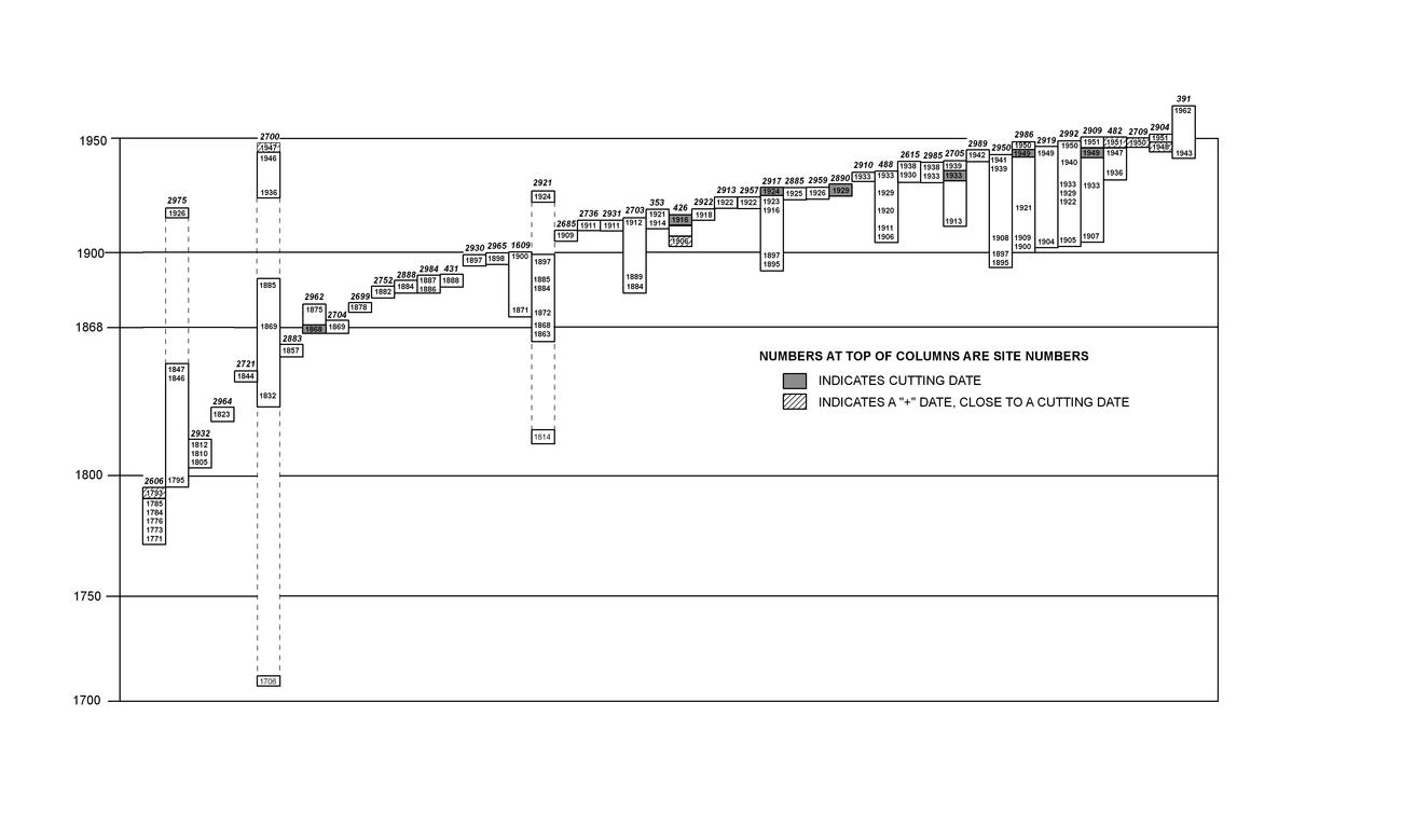 |
Figure 6.1. Tree-ring dated sites in the Chacra Mesa survey area. |
¶ 26 The earliest dates were obtained from ceramics recorded at two small campsites (hearth sites) on Chacra Mesa, 29Mc 476 and 29Mc 479. Both sites are tentatively dated to 1600 to 1680 based on the presence of small numbers of Hawikuh Polychrome sherds (see Table 4.13). This date range is slightly earlier than that for any other known site in the Chaco Canyon area (Brugge 1986:141-142) and is therefore questionable without other supporting data. The earliest reliable tree-ring dates for Navajo sites in the project area are from 29SJ 2606, also on Chacra Mesa. A series of six dates from three hogans range from 1771 to 1793 (Appendix 6.1, Table 2). Interestingly, these dates cluster around the 1781 smallpox epidemic, after which Brugge (1986:143) sees little dwelling construction in Chaco Canyon and on Chacra Mesa. At least two hogans, however, were constructed in the 1780s and/or 1790s at 29SJ 2606.
¶ 27 Occupation of the Kin Bineola, Kin Klizhin, and South Addition survey areas appears to be primarily limited to the late nineteenth and twentieth centuries. The only exception to this is an early component of habitation site 29SJ 2782 in the South Addition, dated ceramically to between 1700 and 1850.
¶ 28 Use of the survey areas as early as the 1880s by Spanish-American sheep herders is indicated by a number of rock inscriptions, especially in the South Addition and Chacra Mesa survey areas. Seasonal use of the area by Spanish-American herders and Anglo ranchers, along with the Navajo, continued into the early 1940s.
¶ 29 The most recent of the tree-ring dates from Chacra Mesa indicate that most activity ended by 1951. It is expected that the Navajo occupation of the Chacra Mesa survey area ceased by the early 1950s as a result of the fencing off of Chaco Canyon National Monument. On Chacra Mesa, a corral at 29Mc 391 produced two dates; 1943++rGB and 1962v, indicating that a corral built during the 1940s was improved upon and reused, probably by a Navajo lessee who ran cattle on the mesa after 1962. Informant information on the other three survey areas indicates that Navajo occupation there also ceased by the mid-1950s. This is generally supported by temporally sensitive historic artifacts recorded in those areas.
Sites
¶ 30 A wide variety of historic sites, mostly Navajo, were recorded by the inventory survey. These sites ranged from large, complex habitation sites to isolated sherd scatters and hearths. To organize this array of archeological remains, a typology was used which provides a basic functional classification of sites using only archeologically observable attributes. Sites were divided into three major categories: Habitations (two types), Temporary camps (six types), and Other sites (13 types) (Table 6.2). The distribution of these site components by time period is presented in Table 6.3.
|
Table 6.2. Number of sites of each type by survey area. |
|||||
|---|---|---|---|---|---|
| Site Type | Kin Bineola | Kin Klizhin | South Addition | Chacra Mesa | Total |
| Habitations: | |||||
| Single Habitation | 5 | 6 | 6 | 33 | 50 |
| Multiple Habitation | 1 | 1 | 2 | 26 | 30 |
| Temporary Camps: | |||||
| Temporary Shelter | 7 | 1 | 6 | 19 | 33 |
| Stockholding Facility | 8 | 3 | 3 | 13 | 27 |
| Unidentified Structure | 2 | 1 | 2 | 4 | 9 |
| Isolated Hearth/Oven | 5 | 2 | 1 | 27 | 35 |
| Sherd Scatter | - | - | - | 6 | 6 |
| Euro-American Refuse | - | 3 | - | 9 | 12 |
| Other: | |||||
| Rock Arta | 1/8 | 2/6 | 8/19 | 61/111 | 72/144 |
| Storage Facility | 1 | - | - | 14 | 15 |
| Sweat Lodge | - | - | - | 20 | 20 |
| Wood Cutting/Wood Pile | - | - | - | 9 | 9 |
| Road/Trail | 2 | - | - | 13 | 15 |
| Agricultural Field | - | 1 | - | - | 1 |
| Water Control | - | 2 | - | 2 | 4 |
| Fence line | - | - | 1 | - | 1 |
| Quarry | - | 1 | - | 3 | 4 |
| Burial | - | - | - | 2 | 2 |
| Doll House | - | - | - | 2 | 2 |
| Mining Claim Marker | - | - | - | 1 | 1 |
| Misc. Stone Features | 2 | - | 1 | 12 | 15 |
| Total: | 34 | 23 | 30 | 276 | 363 |
| aThe first figure is the total number of sites designated as rock art. The second figure is the total number of sites with rock art present. | |||||
Table 6.3. Number of components of each type by time period.
¶ 31 The 21 site types are differentiated by their primary cultural features. When present, habitation structures or temporary shelters were considered the primary features. In the absence of dwellings or shelters, structural features such as corrals, sweat lodges, storage rooms, or structures of unknown function were considered the predominant or primary features. Although the most striking features at many sites were rock art panels, other less imposing features which are assumed to be better indicators of site function were often used to place sites into a site type category. For example, all sites with rock art and hearths were classified as hearth sites and included in the temporary camp category. Even though a large number of the rock art loci were thereby classified as other site types, all rock art is included in the rock art summary later in this chapter.
¶ 32 Navajo homesites as well as campsites of shorter duration are generally referred to as “camps” in the literature (Bailey and Bailey 1982; Brugge 1986; Gilpin 1983; Kelley 1982a). Garrick and Roberta Bailey (1982:337) note that traditionally there were two major categories of Navajo camps: seasonal camps and temporary camps. A seasonal camp was the more permanent, albeit seasonal, residence of a family. There were two types of seasonal camps: summer camps and winter camps. Both were homesites which were reoccupied seasonally by the entire family. Because of the long-term occupation, or anticipated occupation, of these camps, dwelling structures were of a more permanent nature (Bailey and Bailey 1982:337).
¶ 33 In contrast, a temporary camp was occupied by only a portion of the family on a short-term basis. A wide variety of temporary camps existed which were associated with economic activities of relatively short duration. They included sheep camps, farm camps, hunting camps, and plant gathering camps; all short-term satellite camps of a seasonal camp (Bailey and Bailey 1982:337-339). Temporary camps might also include the loci of a number of Navajo ceremonial activities, such as the Squaw Dance.
¶ 34 Sheep camps were the campsites used by either family herders or hired herders as they grazed their flocks around the more permanent seasonal camp. They were the most common of the temporary camps. Herders moved camp as often as every three days, although sheep camps with permanent dwellings were occupied for as long as two to four months at a time (Kelley 1982a:239, 246). Although temporary camps (such as sheep camps which were reutilized frequently) may have had hogans constructed on them, more often the dwelling structure was ephemeral, being a tent, brush shelter or ramada (Bailey and Bailey 1982:339). During the summer, sheep were bedded in the open and corrals were not needed, but winter sheep camps contained corrals of brush or stone (Kelley 1982a:239). On Gallegos Mesa, to the northwest of Chaco Canyon, sheep camps were found to exhibit a wide range of variability depending on the length of occupation. Archeologically, they ranged from small artifact scatters to sites which were virtually indistinguishable from single dwelling permanent camps (Gilpin 1983:969).
¶ 35 Farm camps were sometimes used by families who were primarily herders but also maintained fields. A farm camp consisted primarily of a shade and/or tent and usually a large horno with which to prepare corn during harvest time (Bailey and Bailey 1982:339). Hunting and plant gathering camps were of very short duration. Archeologically, they might be limited to small artifact scatters and possibly associated hearths.
¶ 36 In order to avoid the confusion of using the term “camp” for both permanent and short-term sites, I have called all permanent or seasonal camps “habitations.” Habitations, therefore, may be summer or winter occupations. They are identified by the presence of dwellings, usually one or more hogans, and are often associated with ash or trash piles, corrals, and other domestic features. In some areas, such as at the base of Chacra Mesa near Chaco Wash where water was available year-round, habitation sites could be, and were, occupied during both summer and winter, although in most areas this was not possible.
¶ 37 In the present study, habitations have been divided into two types; multiple habitations and single habitations. Multiple habitations contain more than one habitation structure (usually hogans) and are considered to have been permanent seasonal camps occupied by extended Navajo families. Single habitation sites contain only one detectable habitation structure and are generally thought to have been occupied by a single nuclear family. Most single habitation sites are thought to be permanent seasonal camps. They were generally occupied six to seven months of the year (Kelley 1982a:246); however, as was previously noted, single hogans were at times constructed at temporary campsites (especially sheep camps) and therefore some of the single habitation sites recorded in the Chaco Additions were probably temporary camps rather than permanent. It is in part because of this variability in the function of single habitations that they have been separated from multiple habitation sites in this analysis. Although all the hogans at multiple habitation sites were not necessarily occupied at the same time, the greater number of dwellings (as well as other features) present may indicate that those sites were occupied over longer periods of time. Many probably functioned exactly like single habitation sites, but on the average it is expected that they had longer occupation spans. (This proposition is tested after the site types are described.) The category single habitation site is, therefore, the most difficult site type to categorize in terms of function.
¶ 38 Cultural affiliation could not always be determined for the sites recorded. The vast majority of the sites are presumed to be Navajo, including all of the habitation sites by virtue of the hogans present. Anglo- and Spanish-Americans used the inventory survey areas for herding, but the remains of this activity appear to be limited to temporary camps and rock art panels.
¶ 39 In many cases, the ethnicity of the herders using the camp is indicated by the presence of a hogan or by inscriptions or pictorial rock art. Sites which contained probable Spanish-American or Anglo components are listed in Table 6.4. Some of these sites also saw use by Navajos.
|
Table 6.4. Spanish-American and Anglo site components. |
||||
|---|---|---|---|---|
| Survey Area | Site Type | Site Number | ||
| Spanish-American Sites | ||||
| Kin Bineola | Rock Art | 29Mc 146 | 29Mc 264 | |
| Kin Klizhin | Stockholding | 29SJ 2459 | 29SJ 2471 | 29SJ 2484 |
| 29SJ 2491 | ||||
| Rock Art | 29SJ 2421 | 29SJ 2483 | ||
| South Addition | Stockholding | 29SJ 2822 | ||
| Temporary Shelter | 29SJ 2777 | 29SJ 2792 | 29SJ 2801 | |
| 29SJ 2837 | 29SJ 2838 | |||
| Unidentified Structure | 29SJ 2826 | |||
| Rock Art | 29SJ 2141 | 29SJ 2147 | 29SJ 2150 | |
| 29SJ 2772 | 29SJ 2805 | 29SJ 2821 | ||
| 29SJ 2828 | ||||
| Fence line | 29SJ 2836 | |||
| Chacra Mesa | Temporary Shelter | 29Mc 416 | 29Mc 431 | 29SJ 2891 |
| Hearths | 29Mc 424 | 29Mc 498 | ||
| Rock Art | 29Mc 391 | 29Mc 499 | 29SJ 206 | |
| 29SJ 2536 | 29SJ 2551 | 29SJ 2560 | ||
| 29SJ 2563 | 29SJ 2568 | 29SJ 2569 | ||
| 29SJ 2571 | 29SJ 2576 | 29SJ 2578 | ||
| 29SJ 2625 | 29SJ 2966 | |||
| Anglo-American Sites | ||||
| South Addition | Rock Art | 29SJ 2141 | 29SJ 2782 | |
| Chacra Mesa | Rock Art | 29SJ 203 | 29SJ 1620 | 29SJ 2571 |
| 29SJ 2922 | ||||
Habitation Sites
¶ 40 The largest and most obvious of the historic sites in the project area are Navajo habitation sites. They are recognized by the presence of at least one habitation structure, usually a hogan, although in some cases rectangular houses are present.
¶ 41 Habitation sites in the project area have been divided into two types: single habitations, those with one dwelling present; and multiple habitations, those with more than one. This distinction serves to separate the less complex habitation sites from those which are larger and, as a general rule, aids in distinguishing the size of the social group inhabiting the site. Each hogan at a Navajo habitation site tends to be occupied by a single nuclear family, with contemporary hogans at larger sites being occupied by separate families of the extended family group occupying that site (Brugge 1986:149; Kelley 1982b:51-52; Shepardson and Hammond 1970:44).
¶ 42 Of course, the problem of contemporaneity needs to be considered at multiple habitation sites. It is expected that the most favorable campsites were used over very long periods of time, sometimes continuously, sometimes intermittently. Therefore, the presence of more than one hogan at a site does not necessarily indicate occupation by an extended family. Abandoned hogans on some sites may have been used for storage or as animal enclosures, or may simply have sat unused. Conversely, the absence of surface evidence for more than one hogan at some habitation sites may also be misleading. Additional hogans may have deteriorated beyond recognition or have been robbed for building materials for more recent structures. In addition, the use of tents to accommodate additional family units at these sites often remains undetected without excavation (cf. Gilpin 1983:1427). In fact, in the present project area, informants have revealed that tents were used at some sites where no surface evidence remains (York: field notes3In 1985-1986 Fred York conducted interviews and site visits with Navajo informants at historic period sites identified by the Chaco Additions survey. His field notes, which were later used by Willow Roberts Powers to prepare Chapter 8 are referenced throughout this chapter. York’s field notes are on file at the Chaco Culture National Historical Park Archive at the University of New Mexico.). Because of this, the two types of habitation sites, single and multiple habitations, are not mutually exclusive in terms of site function, although in general, the distinction is a useful one.
Single Habitation Sites
¶ 43 Fifty single habitation sites were recorded in the project area: five in the Kin Bineola area, six in the Kin Klizhin area, six in the South Addition, and 33 in the Chacra Mesa area (Table 6.2). Ten single habitation site components date to the Pre-Bosque Redondo Period (1700 to 1863), 19 to the Post-Bosque Redondo Period (1868 to 1930), and five to the Modern Period (1930 to 1980) (Table 6.3).
¶ 44 The vast majority of these sites are small, containing few structures and features, with little, if any, historic trash associated. The general paucity of debris and outdoor features at these sites strongly suggests that their use was short-term and/or seasonal in nature. Structures associated with single habitation sites are generally limited to storage rooms and/or corrals, although a few ramada-type structures, sweat lodges, miscellaneous walls, and unidentified structures were also noted. The major feature types are defined and described in Appendix 6.2. At 11 of these sites (22 percent) the hogan or house was the only structure in evidence. The range of other features found at single habitation sites is presented in Table 6.5. These include all of the major feature types present at multiple habitation sites, although greater numbers and varieties tend to occur at the latter.
|
Table 6.5. Number of single habitation sites containing each feature type. |
||||||
|---|---|---|---|---|---|---|
| Feature | Kin Bineola | Kin Klizhin | South Addition | Chacra Mesa | Total | Percent1 |
| Hogan | 3 | 5 | 6 | 33 | 47 | 94 |
| House | 2 | 1 | - | - | 3 | 6 |
| Storage Room | 1 | 1 | 2 | 18 | 22 | 44 |
| Corral | 1 | 4 | 4 | 9 | 18 | 36 |
| Lamb Pen | 2 | - | - | 1 | 3 | 6 |
| Sweat Lodge | - | - | - | 6 | 6 | 12 |
| Temporary Shelter | 1 | - | 2 | 3 | 6 | 12 |
| Unidentified Structure | - | - | - | 2 | 2 | 4 |
| Stone Wall | 1 | 2 | - | 2 | 5 | 10 |
| Storage Pit/Cist | 1 | 1 | 1 | 1 | 4 | 8 |
| Hearth | 1 | - | - | 14 | 15 | 30 |
| Beehive Oven | - | 1 | - | 2 | 3 | 6 |
| Ash/Trash Pile | - | 1 | 1 | 10 | 12 | 24 |
| Fire-altered Rock | - | 1 | 1 | 7 | 9 | 18 |
| Rock Pile/Cairn | - | 1 | 1 | 5 | 7 | 14 |
| Misc. Rock Feature | 1 | 1 | - | 2 | 4 | 8 |
| Water Control Feature | - | 1 | 3 | 4 | 8 | |
| Fence line | - | 1 | - | - | 1 | 2 |
| Burial | - | - | - | 3 | 3 | 6 |
| Wood Pile/Scatter | - | - | - | 7 | 7 | 14 |
| Sherds/Lithics | - | - | 2 | 16 | 18 | 36 |
| Euro-American Refuse | 2 | 5 | 1 | 19 | 27 | 54 |
| Rock Art | - | 2 | 1 | 8 | 11 | 22 |
| Trail | - | - | - | 3 | 3 | 6 |
| Road Segment | - | - | - | 5 | 5 | 10 |
| Doll House/ Pebble Cache | - | - | - | 3 | 3 | 6 |
| Coyote Trap | - | - | - | 1 | 1 | 2 |
| Quarry | - | - | - | 1 | 1 | 2 |
| Chicken Coop | - | - | - | 1 | 1 | 2 |
| Dog House | - | - | - | 1 | 1 | 2 |
| 1The percentages shown in this column are the proportion of all single habitation sites (n=50) at which a given feature is present. For example, fire-altered features were found at nine sites or 18 percent of all single habitations. | ||||||
¶ 45 The most complex single habitation sites were found in the Chacra Mesa survey area. These sites contain much more accumulated Euro-American trash then most of those in other survey areas, as well as more numerous associated structures and features. One example is 29SJ 2704 (Figure 6.2), occupied between 1870 and 1930. It consists of a stone hogan, 15 to 17 possible storage rooms which were built into natural alcoves in the exposed Cliff House Sandstone, three to four hearths, a stone stairway between the lower and upper ledges of the cliff face, a rock art panel, and a scatter of Euro-American refuse. Such sites were utilized more extensively than the usual single habitation sites.
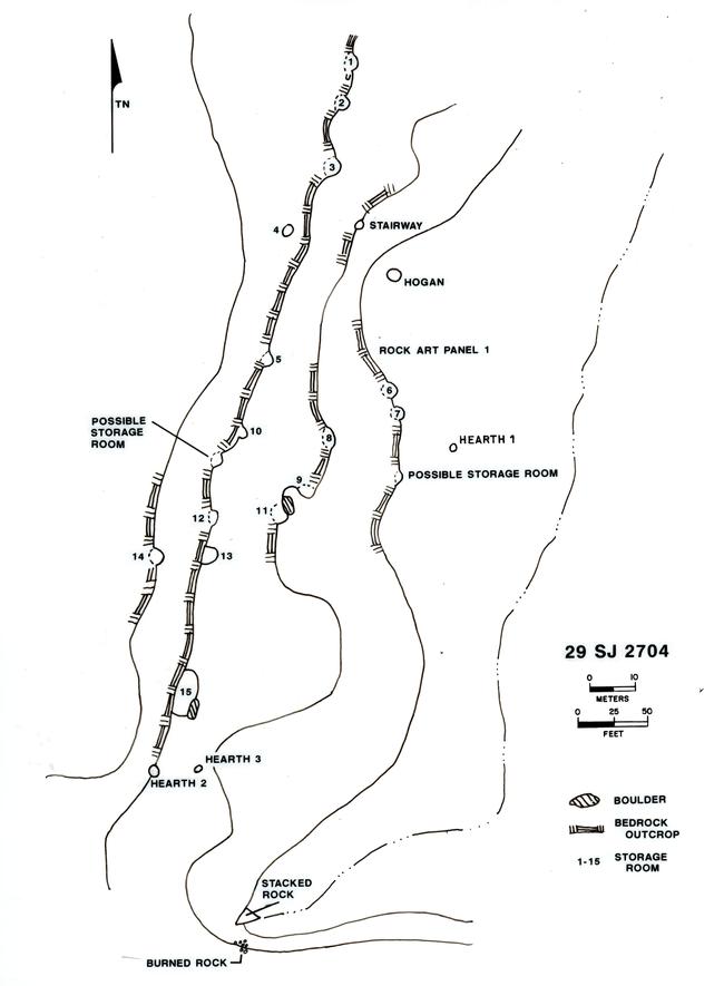 |
Figure 6.2. Plan view of 29SJ 2704, a single habitation site dated to 1870-1930. |
¶ 46 The distribution of features at single habitation sites is largely dependent on local topography. In all four survey areas most of the single habitation sites (74 percent) are situated against sandstone outcrops and ledges, or in rincons or small canyons which have formed in the Cliff House and Menefee Formations. Cliff faces and large scattered talus boulders provide ready shelter from the wind and solar radiation, and are often incorporated into the walls of hogans, storage rooms, and corrals. The use of these natural outcrops produces a more or less linear distribution of features along the base of the cliff or along the various exposed ledges, with directional orientation dependent on the facing of the exposed cliff or ledge (Figure 6.3). Scarps facing in each direction were utilized, although a preference for south and east facing is indicated: twenty-six single habitation sites (70 percent of those sites along cliff faces or ledges) are located at the base of east, south, or southeast facing outcrops.
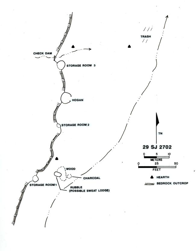 |
Figure 6.3. Plan view of 29SJ 2702, a post-1930 single habitation site. |
¶ 47 A general easterly orientation of features on Navajo sites has been noted in previous research (Gilpin 1983:1435; Sciscenti and Greminger 1962:10) and is sometimes apparent in our project area in the placement of hogan entryways and the presence of ash/trash piles just northeast or southeast of the entryway. Woodcutting areas, and storage rooms which are not built against sandstone outcrops, are also found to the east or southeast of the hogan.
¶ 48 Open sites, located away from sandstone outcrops, exhibit an even stronger tendency for an easterly orientation, with entryways and activity areas toward the east. Corrals are sometimes located to the west or northwest, behind the hogan. Storage rooms and ash and trash piles are generally located just east of the hogan entryway. Ramada-like structures are fairly distant from the dwellings. Wagon roads which pass through open sites run east of the hogans. This generally easterly orientation is exhibited in the layout of 29SJ 2705, one the more complex single habitation sites (Figure 6.4).
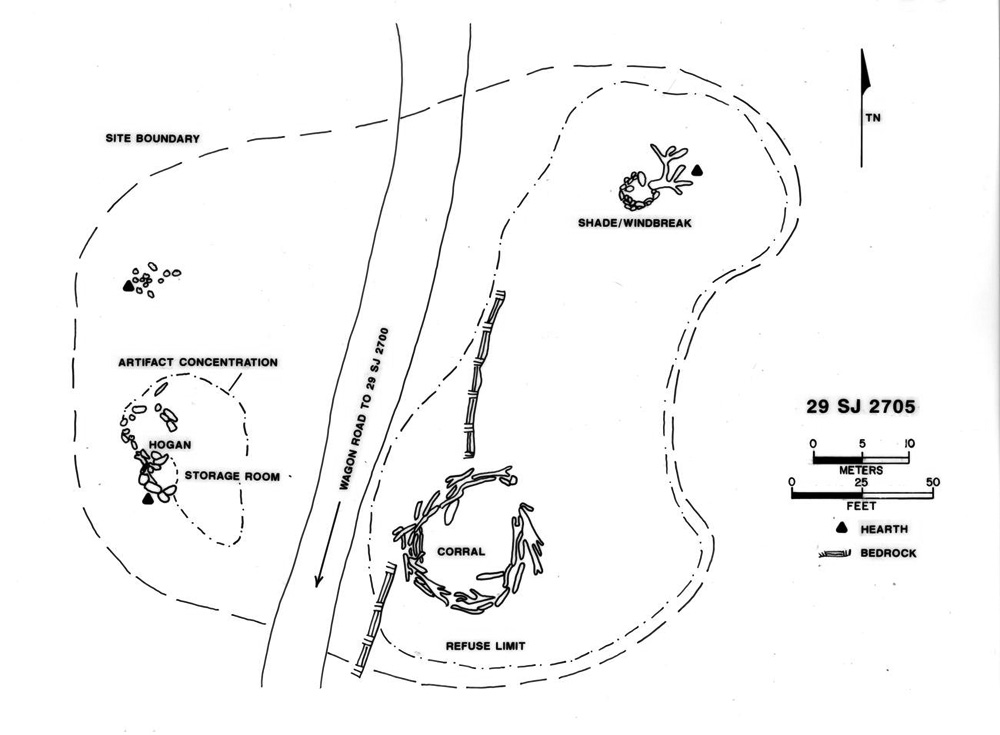 |
Figure 6.4. Plan view of 29SJ 2705, a single habitation site dated to 1922-1960. |
¶ 49 The size of single habitation sites is extremely variable. The number of associated features obviously affects the overall size of the site, but another limiting factor is terrain. The small size of a cañoncito or rincon will sometimes dictate the clustering of site features. The areal extent of single habitation sites in the project area ranges from 15 to 47,500 m2. Site size was based on the area in which all related features and artifacts occur. It includes virtually all artifacts associated with a site, except isolated items occurring a substantial distance from other features or artifacts.
¶ 50 The average single habitation site area is 4,896 m2, but this figure is skewed by the existence of a few very large sites and a more informative statistic is the median site size, 1,880 m2. The largest sites are all located in the Chacra Mesa survey area. In fact, only one single habitation site larger than 4,550 m2 was located in another survey area (Appendix 6.1, Table 3). The exception is site 29SJ2799 in the South Addition.
¶ 51 The mean surface area of single habitation site components in each of the survey areas is broken down by time period in Table 6.6. Too few components are present in the three periods from the Kin Bineola, Kin Klizhin, and South Addition survey areas to allow meaningful comparisons. In the Chacra Mesa survey area, however, the largest sites appear to date to 1868 to 1930 and the smallest to 1930 to 1980. A comparison of site size for single habitations from all periods reveals an average of 6,367 m2 on Chacra Mesa; substantially larger than the average for any other survey area.
|
Table 6.6. Single habitation components: mean area in m2 by time period. |
||||||
|---|---|---|---|---|---|---|
| Kin Bineola | Kin Klizhin | South Addition | Chacra Mesa | All Areas | ||
| 1700-1863 | ||||||
| No. of Comp. | 0 | 0 | 0 | 10 | 10 | |
| Mean Area | 7,851 | 7,851 | ||||
| Std. Dev. | 7,604 | 7,604 | ||||
| 1868-1930 | ||||||
| No. of Comp. | 1 | 3 | 0 | 12 | 16 | |
| Mean Area | 1,960 | 10,152 | 7,994 | |||
| Std. Dev. | 2,019 | 13,343 | 12,090 | |||
| 1930-1980 | ||||||
| No. of Comp. | 0 | 1 | 1 | 3 | 5 | |
| Mean Area | 4,320 | 3,982 | ||||
| Std. Dev. | 2,674 | 2,090 | ||||
| Other | ||||||
| No. of Comp. | 4 | 2 | 5 | 12 | 23 | |
| Mean Area | 987 | 320 | 2,235 | 1,857 | 1,654 | |
| Std. Dev. | 935 | 431 | 3,071 | 3,115 | 2,653 | |
| All Sites | ||||||
| No. of Comp. | 5 | 6 | 6 | 37 | 54 | |
| Mean Area | 830 | 1,487 | 2,621 | 6,367 | 4,896 | |
| Std. Dev. | 883 | 1,585 | 2,905 | 9,205 | 7,976 | |
¶ 52 Hogans were by far the most widely utilized form of dwelling at these sites, making up 47 of the 50 dwellings recorded (Table 6.5). The other three were called "houses," the distinction being in the shape of the floor plan, as similar construction methods were used in both types of dwellings. Hogans, the traditional Navajo dwellings, are ordinarily circular, subcircular, polygonal, or sub-rectangular in plan and normally contain a single room (Jett and Spencer 1981:14). Dwellings which are square-cornered, rectilinear in plan, with vertical walls were called "houses," although in some cases, such as when only a very low outline of the structure remained, the distinction was difficult to make. In the Chaco Country, the construction of true rectilinear houses began no earlier than the 1880s (Brugge 1980:94, 122, 142).
¶ 53 Most hogans (36 out of 47) located at single habitation sites are constructed of simple sandstone slab masonry (Appendix 6.1, Table 4). Unshaped slabs and occasionally larger blocks form circular or oval walls in most of the hogans (Figure 6.5). A few sub-rectangular and D-shaped hogans were recorded as well. Evidence of mortar and chinking stones was seldom present. Occasionally upright sandstone slabs were used in construction and very often a structure was built against a cliff or ledge, which formed part of a wall. Larger talus boulders were also used to form hogan walls at many sites (Appendix 6.1, Table 4). The extensive use of sandstone in hogan construction was clearly a product of its availability in the project area. The talus slopes and exposed outcrops in the extensive canyon system along the northeast side of Chacra Mesa, for instance, would have provided abundant construction material, to be obtained at minimal effort.
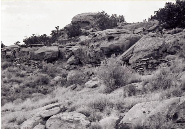 |
Figure 6.5. View of 29SJ 2700, a single habitation site. |
¶ 54 Two, two-room hogans were recorded at single habitation sites on Chacra Mesa, each containing two more-or-less circular or oval rooms. Both of these date to the 1700 to 1863 period and one was re-occupied during the 1868 to 1930 period. Although not common, double hogans have been recorded elsewhere on Chacra Mesa (Brugge 1978:43) and in Chaco Canyon (Malcolm 1939:10-11). Both 2-room hogans were constructed against sandstone outcrops, and the desire to take advantage of the large expanse of these natural features may have made the construction of these unusual dwellings convenient.
¶ 55 Interior hogan diameter at single habitation sites ranges from 1.7 to 5.3 m (Appendix 6.1, Table 4). Most hogans fall within the 2.6 to 4.6 range (mean 3.6; s.d. 0.99). An analysis of variance (ANOVA) comparing the mean floor areas of hogans from the three temporal periods rejects the null hypothesis that the are no significant differences (F [2, 28]=5.90, p <0.01). Over time the mean floor area increases from 7.1 m2 (s.d. 4.5) during 1700 to 1863, to 11.8 m2 (s.d. 5.5) during 1868 to 1930, to a mean of 16.0 m2 (s.d. 3.2) for hogans dated after 1930. Tukey’s family error rate between pairwise comparisons indicates that the mean hogan floor areas for the 1700-1863 period is significantly different from the floor area for the 1930 to 1980 period, but mean hogan floor areas for the 1700-1863 and 1868-1930 periods are not significantly different. Some of the smaller hogans were probably animal enclosures or human shelters intended for very temporary use rather than homes intended for habitation by an entire family (cf. Kelley 1982b: 51-52).
¶ 56 Wall height at present varies from one to nine courses with a maximum wall height of 1.3 m. On the average, walls currently stand three to four courses, or to a height of one-half meter (Figure 6.6). Brugge (1986:39) suggests that most of the low stone hogan rings probably represent wooden hogans. The low height of masonry in hogans in our survey area and the amount of rubble associated with them indicates that, indeed, the upper walls and roofs were constructed of wood or brush, probably of cribbed logs. Intact cribbed-log roofs were recorded at one single habitation site and one multiple habitation site in the project area.
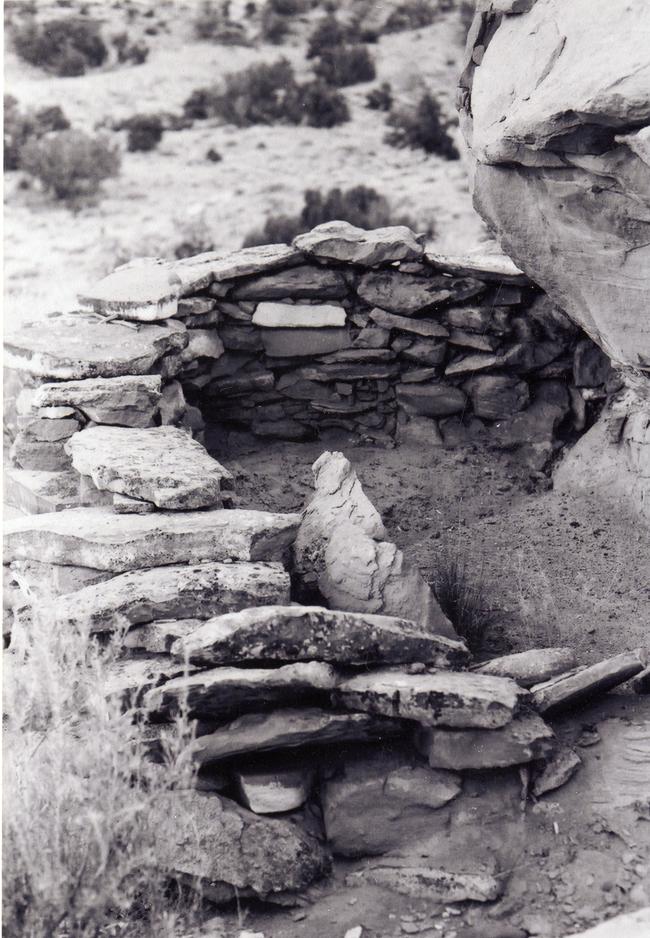 |
Figure 6.6. View of hogan dated to 1945-1949 at 29SJ 2700, a single habitation site. |
¶ 57 Stone hogans were popular in northwestern New Mexico during the late nineteenth century (cf. Brugge 1980:120; Reher 1977:38; Sciscenti and Greminger 1962:10; Sessions and Williams 1979:204) and were in use in the Chaco area as early as the mid-eighteenth century (Brugge 1986:133). The earliest tree-ring dated stone hogan in our project area was constructed in the late eighteenth century. It is located at a multiple habitation site, 29SJ 2606 (Appendix 6.1, Table 2).
¶ 58 Previous research has indicated that dwellings built before the internment at Fort Sumner (1864 to 1868) were often the more traditional forked-stick hogans (Brugge 1980:27; Keur 1941:69; Vivian 1960:8), and that this dwelling form became extremely rare by the early twentieth century (Brugge 1980:266). Only four possible forked-stick hogans were recorded at single habitation sites, all in the Chacra Mesa survey area. Two are dated by ceramic association to the period 1700 to 1863; the other two are dated to 1868 to 1930. No standing forked-stick hogans were located. All forked-stick hogans recorded were indicated by the presence of circular sandstone slab foundations with either ash or collapsed branches indicating a wooden superstructure. One contains an interior masonry storage bin. Only five masonry hogans at single habitation sites contained evidence of internal features: three had internal hearths, one contained an internal storage bin, and one an interior cist (Appendices 6.2 and 6.1, Table 4).
¶ 59 The three houses located at single habitation sites were in the Kin Klizhin and Kin Bineola survey areas. All are poorly preserved, small rectangular masonry structures. At 29SJ 2484 only a foundation of large boulders remains, with evidence of a possible stone floor and a doorway on the east side. The houses at 29Mc 225 and 29Mc 284 have simple sandstone masonry walls.
¶ 60 Storage rooms were built using the same construction techniques as hogans, but they are smaller and more varied in floor plan. All but one are masonry, utilizing simple sandstone slab construction with slabs stacked horizontally and sometimes vertically. A single brush enclosure within an overhang was also identified as a possible storage feature by the field crew. The natural crevices and alcoves in sandstone ledges were heavily utilized in the construction of storage rooms. Often only a small wall was needed across the front of an appropriately-sized crevice. Storage features of this type were used historically by the Navajo, usually to store corn, beans, dried squash, and dried melon (Hill 1938, cited in Malcolm 1939:15-16).
¶ 61 In many cases it was not possible to be sure these rooms were used for storage. Distinguishing storage rooms from lamb pens was a major problem during the project, in that the two feature types were archeologically indistinguishable. Survey crews tended to categorize small masonry structures built against sandstone outcrops as storage rooms. Later, many of these were identified by Navajo informants as lamb pens. Informants indicated that still others apparently served as dog houses (York: field notes). As such, when informant information was not available, the field assessment of whether a structure was a storage room or lamb pen was accepted for the present analysis; the accuracy of those assessments, however, is questionable. There appears to have been no significant change through time in the use of storage features (Table 6.7). Evidence of subsurface storage pits or cists was found at only three single habitation sites, although they are known to have been a popular form of storage (Hill 1938:42, 43; Jett and Spencer 1981:187; Winter 1983:485). Their general absence from feature lists at sites in the project area is most likely a result of their lack of visibility.
|
Table 6.7. Major features present at dated single habitation components. |
|||
|---|---|---|---|
| 1700-1863 | 1868-1930 | 1930-1960 | |
| No. of Habitation Components | 10 | 16 | 5 |
| No. with Corrals | 1 (10%) | 9 (47%) | 4 (80%) |
| No. with Storage Facilities | 7 (70%) | 11 (58%) | 3 (60%) |
| No. with Wood Cutting Areas or Wood Piles | 2 (20%) | 2 (11%) | 0 |
| No. with Sweat Lodges | 1 (10%) | 4 (21%) | 1 (20%) |
| No. with Temporary Shelters | 0 | 1 (5%) | 1 (20%) |
| Note: Percentages shown in this table represent the proportion of components of a given time period at which a given feature type is present. For example, in the 1930-1960 time period, four (80%) of five single habitations have corrals. | |||
¶ 62 Corrals are present at 18 of the 50 single habitation sites (36 percent) and lamb pens at three (Table 6.5). Two corrals were found at each of five sites. All other sites have only one corral. Corrals, too, were not always clearly identifiable from the extant remains. Six of those recorded at single habitation sites were tentatively identified, based on the presence of incomplete or badly deteriorated walls. The two corrals at 29Mc 279 are just small enough and so poorly preserved that they may have actually been hogans. Most corrals were built of sandstone rubble (Figure 6.7), although sometimes brush was incorporated into walls. Many corrals in the survey areas were probably constructed of brush and timber, and are now indistinguishable. Large talus boulders were often used in forming the walls, and in 17 of the 24 corrals a ledge or rincon formed part of the enclosure. Only seven of the corrals are free-standing. Shape and size are extremely variable. The largest is at 29SJ 2984, where a barricade constructed of masonry and brush closes off the end of a rincon, an area of 63 by 30 m. Another smaller corral is also present at this site. Site 29SJ 2700 had four lamb pens surrounded by a corral (Figure 6.8).
 |
Figure 6.7. View of corral at 29SJ 2478, a single habitation site dated to 1910-1920. |
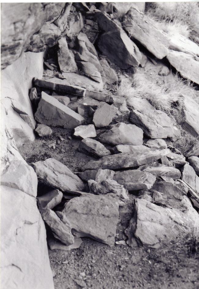 |
Figure 6.8. View of lamb pen at 29SJ 2700, a single habitation site with a component dated to 1945-1949. |
¶ 63 The number of single habitation components with corrals present increases through time from 10 percent during 1700 to 1863, to 47 percent during 1868 to 1930, and 80 percent after 1930 (Table 6.7). On the surface, this would appear to indicate an increase through time in the number of families owning livestock; however, how much of this is due to differential preservation is not known. Corral preservation is certainly better for the later periods. Changes in site function and herding practices may also have contributed to the observed increase in the occurrence of corrals.
¶ 64 The remains of sweat lodges were found at six of the single habitation sites on Chacra Mesa. Two of these sites had evidence for two sweat lodges; the other four had only one. Four of these dated to 1868 to 1930. One sweat lodge was dated to each of the 1700 to 1863 and 1930 to 1980 periods (Table 6.7). No standing structures were found, although in most cases several juniper poles were noted in association with large stock piles of fire-cracked rock and rock heating hearths. All sweat lodges were located at least 25 m from the nearest hogan. Rincons or curvature of the sandstone outcrops were often used to obscure the view toward a sweat lodge from the hogan and general activity area.
¶ 65 Two open summer shelters were recorded at single habitation sites, both in the Chacra Mesa survey area. Each consists of an arc of stone and brush, forming a windbreak or shade, opening to the east. In one, several upright posts were used to hold up the brush and deadwood walls. Four other possible windbreaks or shades were identified by the presence of semi-circular areas of sandstones. Of these four, two were found in the South Addition, one in Chacra Mesa, and one in the Kin Bineola survey area. A tent platform at 29Mc 416 on Chacra Mesa was identified by the ethnohistorian.
¶ 66 Three masonry structures of unknown function were also recorded at two single habitation sites (Appendix 6.1, Table 4). Smaller domestic features associated with the single habitation sites included outdoor hearths, ash piles, trash piles, concentrations of fire-altered rock, unburned rock piles and cairns, scatters of cut wood, and historic ceramics or lithics. Hearths were often located within the general activity area in front of a hogan, although locations distant from dwellings were not uncommon.
¶ 67 Ash piles, which excavations elsewhere have shown to be consistently associated with hogans on permanent campsites (Gilpin 1983:1435), were found at 12 (24 percent) single habitation sites (Table 6.5). They tend to be located immediately east, southeast, or northeast of the hogan entrance and contain fragments of burned bone, metal, glass and small sandstone spalls or slabs as well as ash and charcoal. Their size is variable, as they are often combined with, or converge with, scatters of trash. Euro-American trash is generally not present in large quantities. Many of the earlier sites contain scatters of historic Navajo and/or Puebloan ceramics, or pot drops.
¶ 68 Rock piles, scatters, and areas of fire-altered rock are also found in all areas of single habitation sites. Wood features at single habitation sites include a possible wood chopping area and six scatters of cut or milled wood. The wood chopping area is located directly southeast of the hogan it is associated with. Wood scatters show no particular placement on sites. Wood features date to both 1700 to 1863 and 1868 to 1930 (Table 6.7).
¶ 69 Three single habitation sites contained the remains of possible Spanish-style beehive ovens. In all cases, the features were collapsed concentrations of burned and unburned sandstone slabs and the identifications are tentative.
¶ 70 Evidence of child’s play was found at two sites in the form of miniature houses or hogans. At one of these sites, 29SJ 2582, a doll house was constructed on the cliff ledge behind the hogan and a series of wind erosion pockets along the same ledge were filled with sandstone spalls. Another doll house at 29SJ 2968 measures 0.4 m in diameter and although it is now largely collapsed, one can discern that it was originally roofed with small branches. At a third site, 29SJ 2959, a large pile of sandstone concretions is located under a ledge near the hogan. Brugge (1986:127) suggests that such caches of stones may be children’s playthings, as they appear to have no other useful purpose.
¶ 71 The presence of Navajo burials is indicated at three single habitation sites. They are described with the other burials later in this chapter.
¶ 72 Features which were found rarely at single habitation sites include check dams, wire fence lines, a coyote trap, a sandstone quarry, and a talus boulder exhibiting axe-sharpening grooves. Trails leading up (or down) sandstone ledges were found at three single habitation sites and segments of historic wagon roads were visible at five sites.
¶ 73 Finally, rock art and/or inscriptions were found at 11 of the 50 single habitation sites. Because this feature type makes up such a large proportion of the features and site types in the project area, all rock art is discussed in a later section of this chapter.
Multiple Habitation Sites
¶ 74 Thirty multiple habitation sites were recorded in the project area (Table 6.2). These multiple habitation sites contain from two to twelve habitation structures. Most (77 percent), however, have only two or three hogans or houses (Appendix 6.1, Table 5). Sites in this category are generally considered to have been more heavily used than the single habitations, as indicated by the presence of substantially greater quantities and varieties of cultural features and debris. (This is detailed in Testing the Site Typology, below). Multiple habitation sites for which ethnohistoric information is available served as either permanent “winter” camps or sheep camps which were used over an extended period of time. Nine of the multiple habitation site components were occupied during 1700 to 1863, seven during 1868 to 1930, and seven during 1930 to 1980 (Table 6.3). Several of these sites were occupied during more than one of these periods (Table 6.1).
¶ 75 Like single habitation sites, the more complex multiple habitations are located in the Chacra Mesa area, indicating greater use of that area for winter or permanent camps. Some of the most complex were campsites of Choche’s family and his descendants. Choche was the major livestock owner in the area (Brugge 1986:145). The most simple sites in the multiple habitation category include four sites with only two hogans, two sites with only hogans and a corral, and one site with only three hogans and a scatter of sherds. Sites such as these are probably more similar, functionally, to the single habitations than to most other multiple habitation sites. They may have served as sheep camps.
¶ 76 The most common structures recorded on multiple habitation sites were hogans, storage rooms, and corrals. Rectangular houses, lamb pens, ramadas or shelters, sweat lodges, and unidentified structures are also present, but in much lower numbers (Appendix 6.1, Table 5). An array of additional non-structural domestic and production features is also present. Outdoor hearths, ash and/or trash piles, burned and unburned rock concentrations, sherd and lithic scatters, and Euro-American refuse are predominant. They are tabulated by survey area in Table 6.8. Features found at multiple habitation sites which were not found at single habitation sites include coal mines, developed seeps, the possible base of a feeding trough, and a tent platform and peg. The presence of available coal and seeps at some of these sites was probably an important factor in the more permanent use of those locations.
Table 6.8. Number of multiple habitation sites containing each type of feature.
¶ 77 As Brugge (1986:5) notes in earlier work on Chacra Mesa, the sheltered heads and rincons of canyons on the northeastern side of Chacra Mesa provided especially favorable environments for residence because they occasionally contained springs or groundwater near the surface and protection from sun and wind. Sandstone outcrops, cliffs, ledges, and large talus boulders were heavily utilized in construction, being incorporated into hogan, corral, and storage room walls. Almost all of the 30 multiple habitation sites were located in areas protected by sandstone cliffs or ledges (Figure 6.9; Appendix 6.1, Table 5). Thus, as was the case for single habitation sites, site layout is affected by the use of available outcrops for construction.
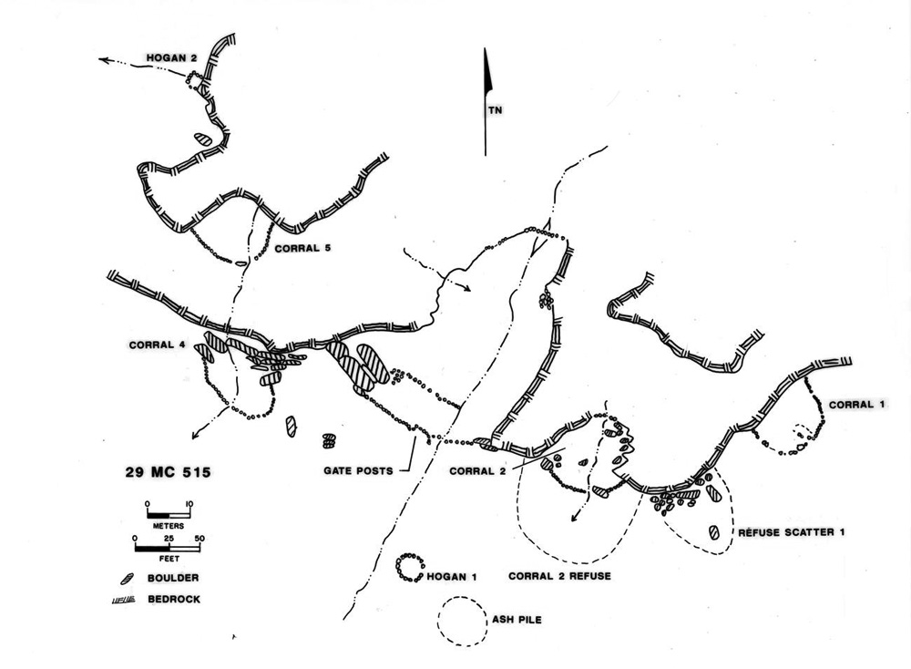 |
Figure 6.9. Plan view of 29Mc 515. |
¶ 78 There is no real pattern to the placement of hogan or household complexes on these sites. Hogans are scattered across sites along the base of outcrops or are in the open. Spacing between hogans (or houses) is extremely variable, ranging from less than 5 m to 128 m between nearest neighbors. Distances of 20 to 50 m are common. On larger sites, such as 29SJ 2966 and 29SJ 2606, where clusters of hogans and associated features are found, each cluster is likely a distinct temporal component (Figures 6.10 and 6.11). Features such as ashpiles and trash scatters, wood chopping areas, and sometimes, hearths are often associated with particular hogans, being located in front, usually to the east, northeast, or southeast of the hogan. Other features, such as corrals and storage rooms, are usually located apart from the dwellings.
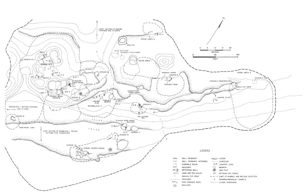 |
Figure 6.10. Plan view of 29SJ 2606, a multiple habitation site dated to 1776-1850. Roomblocks 1 and 2, and Room Areas 1-3 are from an earlier Anasazi occupation of the site. |
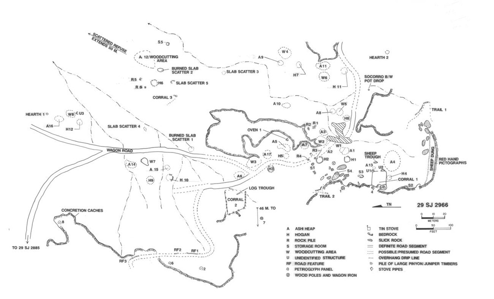 |
Figure 6.11. Plan view of 29S 2966, a multi-component multiple habitation site which served as a major winter residence between 1940 and the early 1950s. |
¶ 79 The surface area covered by multiple habitation site components ranges from approximately 324 m2 to 57,500 m2 (Appendix 6.1, Table 6). The average site size (12,790 m2) is considerably larger than for single habitations (4,896 m2). This reflects the presence of a few very large sites in the Chacra Mesa survey area, although the median site size is still a substantial 10,000 m2. The largest multiple habitation sites are all in the Chacra Mesa survey area. Surface area of multiple habitation site components is broken down by time period in Table 6.9. Only the Chacra Mesa survey area contained sufficient numbers of sites for each period to produce meaningful average figures. There, sites occupied from 1700 to 1863 are substantially smaller than those dating to the two more recent periods.
|
Table 6.9. Multiple habitation components: mean area in m2 by time period. |
||||||
|---|---|---|---|---|---|---|
| Kin Bineola | Kin Klizhin | South Addition | Chacra Mesa | All Areas | ||
| 1700-1863 | ||||||
| No. of Components | 0 | 0 | 1 | 8 | 9 | |
| Mean Area | 9,279 | 10,559 | ||||
| Std. Dev. | 6,448 | 7,150 | ||||
| 1868-1930 | ||||||
| No. of Components | 0 | 1 | 0 | 6 | 7 | |
| Mean Area | 16,048 | 14,616 | ||||
| Std. Dev. | 9,039 | 9,078 | ||||
| 1930-19803 | ||||||
| No. of Components | 0 | 0 | 0 | 7 | 7 | |
| Mean Area | 18,010 | 18,010 | ||||
| Std. Dev. | 18,049 | 18,049 | ||||
| Other | ||||||
| No. of Components | 1 | 0 | 1 | 6 | 8 | |
| Mean Area | 11,592 | 9,134 | ||||
| Std. Dev. | 7,998 | 8,185 | ||||
| All Sites | ||||||
| No. of Components | 1 | 1 | 2 | 27 | 31 | |
| Mean Area | 12,000 | 13,561 | 12,790 | |||
| Std. Dev. | 12,445 | 11,300 | 11,095 | |||
¶ 80 Habitation structures at multiple habitation sites include 93 hogans and three houses. Hogans are present on all 30 sites. Most are like those described for single habitation sites, circular or oval constructs of simple sandstone slab masonry (Figures 6.12 and 6.13). The masonry walls presently stand from one to nine courses high, with a maximum wall height of 1.4 m. Evidence of mortar is usually not present, although it is present in three of the best-preserved hogans, all at 29SJ 2966.
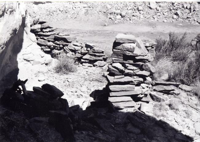 |
Figure 6.12. View of Hogan 1 at 29SJ 2606, a multiple habitation site dated to 1776-1850. |
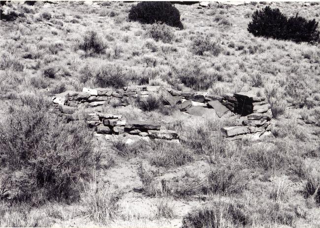 |
Figure 6.13. View of a well-preserved hogan ring (Hogan 1) at 29SJ 2908, dated to 1910-1935. |
¶ 81 The doorways in the three hogans at 29SJ 2966 are framed with wooden posts. Most commonly, door frames are made of large upright sandstone slabs. One hogan (at 29SJ 2701) has a possible passage entryway extending out from the main structure about 80 cm. Like the hogan, the sides of the entryways are of simple sandstone masonry. Passage entryways have been recorded on hogans elsewhere in Chaco Canyon (Malcolm 1939:7) and on Big Bead Mesa (Keur 1941:29).
¶ 82 Evidence of interior hogan features was found at several sites. Eight hogans exhibit fire-reddening on interior walls where hearths were probably located. Three contain evidence of internal bins or storage cists formed of upright slabs. One hogan which was built against a cliff has a small niche in the cliff wall, which was probably used as a storage space. Several hogans were dug into the talus slope. Sometimes up to 2.4 to 2.7 m of earth was removed from the uphill side to form a level floor inside the hogan.
¶ 83 Interior diameter of stone hogans ranges from about 2 m to 7.4 m (mean=3.4 m; sd=0.97 m). The smallest hogan at a multiple habitation site measures 1.7 x 1.87 m (Appendix 6.1, Table 5). Diameters of 2.5 to 4.0 m were most common and hogans with diameters of more than 4.0 m are more common at multiple habitation sites than single habitations.
¶ 84 As was found with single habitation sites, the average floor area of hogans at multiple habitations increased significantly through time. An analysis of variance (ANOVA) rejected the null hypothesis that there was no significant difference in the mean hogan floor area between the 1700-1863, 1868-1930, and 1930-1980 time periods (F [2,48]=8.53, p<0.01). For the period 1700 to 1863, mean floor area was 7.5 m2 (s.d.=4.1). For 1868 to 1930, the mean floor area increased to 12.9 m2 (s.d.=5.8), and for 1930 to 1980 mean floor area increased again to 14.0 m2 (s.d.=6.0). Tukey’s family error rate between pairwise comparisons indicates that the mean hogan floor area for the 1700-1863 period is significantly different from the two subsequent time periods, but the latter two periods are not significantly different from each other. Klara Kelley (1982b:53) found a similar trend at sites near Black Hat, New Mexico, which she attributes to an increased length of occupation during the year at dwelling sites. The greater the proportion of the year a dwelling was occupied, the more activities were necessarily performed there and the more goods stored inside.
¶ 85 Brush, logs, or poles, the likely remains of roofs, found in association with hogans were much more commonly found at multiple habitation sites. At least partially intact cribbed-log roofs were present on hogans at 29SJ 2966 (a multiple habitation site) and 29SJ 2700 (a single habitation site), providing us with a picture of how most roofing was probably constructed (Figure 6.6). The four hogans with intact roofs have standing masonry walls between 1.10 and 1.35 m high. It is presumed, therefore, that most other stone hogans in the project area were built of masonry to that approximate height and then roofed with cribbed logs. There is evidence that after abandonment some of the stone hogans were stripped of construction materials, particularly roof beams, for use in building new hogans. Brugge (1986:29) notes that beams used at 29SJ 2700 (Brugge’s Site “N”) are said to have originally come from structures at another site north of Chaco Wash. Several of the hogans show indications of reuse for other purposes after abandonment. At least one abandoned hogan appears to have been reused for storage.
¶ 86 Only one double hogan was recorded at the 30 multiple habitation sites. This structure could not be dated to a specific period. Other hogan types include the forked-stick variety and several with no standing walls. Those with no walls consist of mere depressions with a few scattered sandstone slabs and the type of construction is unknown. The remains of three probable forked-stick hogans were recorded at one multiple habitation site, 29SJ 2606. Seven masonry hogans and a house were also present on this site. Tree-ring dates from two of the forked-stick hogans and one stone hogan produced dates from 1771 ++G to 1793 +rGB (Appendix 6.1, Table 2), suggesting construction occurred in the 1780s or 1790s and that the two types were contemporaneous. Ceramic dates from the site corroborate this time frame. The forked-stick hogans (Hogans 9, 10, and 11) are clustered at the southeastern edge of the site (Figure 6.10), each identified by the presence of a sandstone slab foundation. Two exhibited long juniper poles scattered over the foundations, one with two forked-end poles. The third forked-stick hogan appears to have been built against three large talus boulders.
¶ 87 Houses at multiple habitation sites were built very much like stone hogans and are distinguished only by their rectangular floor plans. All three are simple rectangular structures located on sites which also contain circular hogans. The house at 29SJ 2459, in the Kin Klizhin survey area, is unique (Figure 6.14). It dates to between 1920 and 1935. The main room of the house is dug into a low shale hill. The walls are lined with compound sandstone slab masonry, standing to a height of 1.9 m. The room contains two slab-lined shelves in the west wall and a window in the south wall. A short masonry-lined passageway extends east from the main room into a second room outlined by sandstone blocks. This second room contains a slab-lined box (possible fireplace) and a shelf. A more recent addition to the structure is an 11 by 12 m rectangular compound outlined by upright juniper posts, probably used as a corral.
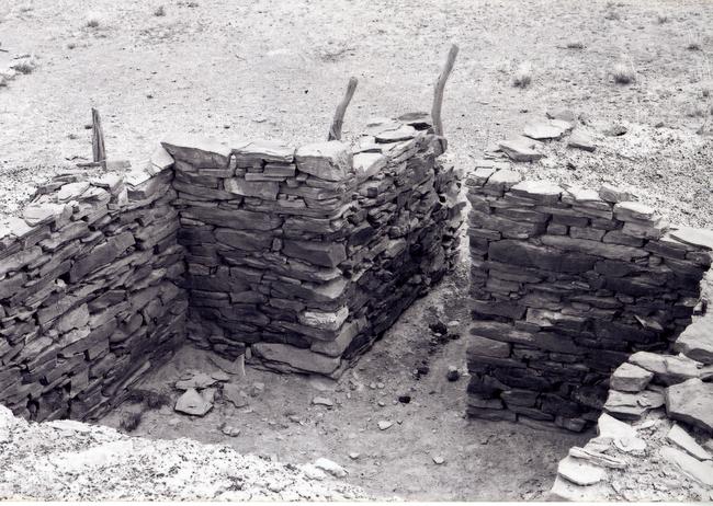 |
Figure 6.14. View of house at 29SJ 2459, a multiple habitation site dated to 1920-1935. |
¶ 88 Storage facilities are present on 13 of the 30 multiple habitation sites (Table 6.8). They include storage rooms, cists, and bins (see Appendix 6.2 for definitions). The number of storage rooms is usually limited to one or two, although as many as five were noted. They were found in association with 1868 to 1930 and 1930 to 1980 period site components (Table 6.10). Construction of storage rooms was like that at single habitation sites. Most are stone, generally dry-laid, roughly stacked sandstone slabs closing off a space partially formed by a ledge or outcrop of talus boulders. In two of the five storage rooms at 29SJ 2966, remnants of the wooden roof remain (Figure 6.15), one with upright roof posts still in situ. Unoccupied hogans at some of the sites may also have been used to store food and equipment.
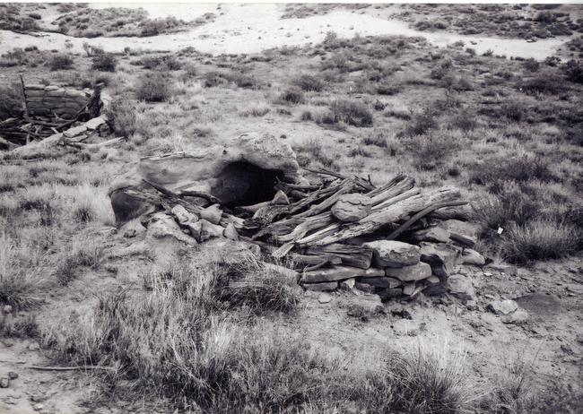 |
Figure 6.15. View of a storage room at 29SJ 2966, a multiple habitation site dated from 1940 to the early 1950s. |
|
Table 6.10. Major features present at dated multiple habitation components. |
|||
|---|---|---|---|
| 1700-1863 | 1868-1930 | 1930-1960 | |
| No. of Habitation Components | 9 | 7 | 7 |
| No. with Corrals | - | 5 (71%) | 4 (57%) |
| No. with Storage Facilities | - | 3 (43%) | 4 (57%) |
| No. with Wood Chopping Area or Wood Piles | - | 2 (28%) | 4 (57%) |
| No. with Sweat Lodges | - | - | 2 (28%) |
| No. with Temporary Shelters | 1 (11%) | 2 (28%) | 2 (28%) |
| Note: Percentages shown in this table represent the proportion of components of a given time period at which a given feature type is present. For example, in the 1930-1960 time period, four (57%) of seven multiple habitations have corrals. | |||
¶ 89 Corrals are present at 14 (47 percent) of the multiple habitation sites, lamb pens at two (Table 6.8). Both lamb pens are small masonry enclosures. Construction of corrals is highly variable. Most are built of stacked sandstone slabs and/or blocks or stacked brush. Several are of wood post and barbed wire construction. As at single habitation sites, the corrals commonly take advantage of sandstone outcrops in forming an enclosure. An excellent example of this is found at 29Mc 515 (Figure 6.9), where five corrals are formed in natural alcoves. Corral size ranges from small circular structures less than 3 m in diameter to the large “V”-shaped enclosure at 29Mc 515, which measures 57 by 30 m. No corrals were recorded with Pre-Bosque Redondo components. Seventy-one percent of the 1868 to 1930 multiple habitations and 57 percent of the 1930 to 1980 multiple habitation components contained corrals (Table 6.10).
¶ 90 At both single and multiple habitation sites, the mean area enclosed by corrals for the Post-Bosque Redondo Period (1868 to 1930) was compared with mean corral area for the Modern Period (1930 to 1980), revealing no significant change in size through time (t[14]=0.382, p=0.708). From 1868 to 1930 the average total area enclosed by corrals (per site) was 446 m2 (sd=517). For 1930 to 1980 it was 359 m2 (sd=271). Although not statistically significant, this 20% reduction in corral size probably reflects the effects of the stock reduction program which was implemented in 1934. Why corral size did not decline more is difficult to determine. The smaller than expected size decline could be a product both of the relatively small sample of corrals, and the difficulty of precisely dating them.
¶ 91 Temporary shelters are found at seven multiple habitation sites, most (6 out of 7) in the Chacra Mesa survey area (Table 6.8). These structures are generally indicated by sparse remains: outlines of sandstone rubble or small wall segments, sometimes with associated brush. A very small rock shelter (2.3 by 1.7 m) is located at one site. Shades or windbreaks are suggested by the presence of standing juniper limbs at two sites (Figure 6.16). The presence of a tent is indicated on at least one site, 29SJ 2703, where a tent peg with an associated wood cutting area and trash scatter were found. A flattened area at 29SJ 2986 with an ash pile and wood cutting area to the southeast may also have been a tent platform. Temporary shelters are found at multiple habitation components from all three time periods (Table 6.10).
 |
Figure 6.16. View of shade or windbreak remains at 29Mc 491, a post-1930 multiple habitation site. |
¶ 92 The remains of three sweat lodges were found at three sites, all on Chacra Mesa (Table 6.8). Two of these sites are dated to the 1930 to 1980 time period (Table 6.10). More habitation sites probably had sweat lodges than the data indicate, but many were located so far from habitations that they were recorded separately. None of the three sweat lodges recorded remain standing and only two contain scattered tree limbs which were probably part of the superstructure. The identification of these structures is based primarily on the presence of burned sandstone scatters or piles and rock heating hearths. As at single habitations, the sweat lodges are all located away from habitations and general activity areas, on the peripheries of sites.
¶ 93 Wall segments of unknown function and other unidentified structures were recorded at six sites (Table 6.8). These are generally thought to be the remains of poorly preserved storage rooms, lamb pens, or temporary shelters such as windbreaks. A sandstone slab foundation, said to be the base of a feeding trough used by Hispanic herders, was found at one Navajo multiple habitation site reused as a sheep camp (York: field notes).
¶ 94 Other features commonly found on multiple habitation sites are hearths, ovens, ashpiles and/or trash scatters, fire-altered rock, rock piles and other rock features, water control features, rock art, wood chopping areas, trails, road segments, sherd and lithic scatters, and general Euro-American refuse (Table 6.8). The abundance and nature of these features do not differ markedly from those at single habitation sites. Less frequently found on multiple habitations are old fence lines, burials, wood piles or scatters, coal mines, clay quarries, and evidence of children’s play such as doll houses and a stone concretion cache.
¶ 95 Ash piles, trash scatters, and wood cutting or wood chopping areas are overwhelmingly associated with specific hogans on multiple habitation sites and, with the hogans, comprise distinct activity areas. Ash piles were found in association with 35 hogans at 18 sites. This is 38 percent of the hogans at multiple habitations sites, compared with 24 percent of the hogans at single habitation sites containing ash piles. Two ash piles were found in isolation, probably indicating the locations of vanished habitation structures or tents. As expected, ash piles are nearly always located to the east, southeast, or northeast of the hogan entryway, usually within 10 m of the structure. Trash piles were found in association with 14 hogans. Although generally within 10 m of the hogan entryway, they are found in all directions from the structure. Sixty-four percent are located from 45 (NE) to 135 (SE) degrees from the entryway, indicating a trend toward eastern placement. Ash piles and trash piles are, however, often mixed or overlapping.
¶ 96 Wood chopping areas were noted at six sites (Table 6.8), in association with 16 different hogans. They tend to be located east or northeast of a hogan. All six of these site components date to the two most recent periods, 1868 to 1930 and 1930 to 1980 (Table 6.10).
¶ 97 Outdoor hearths and/or baking pits were found at 16 multiple habitation sites. Ovens were found at six; only one of which lacked a hearth or baking pit (Table 6.8). These features are scattered throughout sites, although they sometimes appear to be associated with particular hogan activity areas. The remains of ovens are generally collapsed heaps of sandstone slabs, burned on one side. All are circular and measure between 0.8 and 1.2 m in diameter. They are constructed of stacked sandstone slabs or uprights. One is still roofed with a piece of sheet metal covered with slabs.
¶ 98 A possible burial was recorded at 29SJ 2699, located in a bedrock crevice. It consists of a number of branches covering an opening into an overhang.
¶ 99 Coal mines were recorded at two multiple habitation sites, both in the South Addition. Two mine tunnels are present at 29SJ 2782, each 15 to 20 m deep and 0.5 to 1.0 m tall. They were used in the 1930s by the Civilian Conservation Corp (CCC). At 29SJ 2790, excavations along the coal seam in a sandstone outcrop suggest that the inhabitants of the site were mining coal. Bailey and Bailey 1982:48) note that coal was not used by Navajos before 1900; this suggests that 29SJ 2790 was occupied after that time.
¶ 100 Water control features in the form of check dams which were probably built by Navajos were recorded at seven multiple habitation sites (Table 6.8). A series of 17 check dams was found along a drainage running through one site. Two developed springs were found at 29SJ 1620. These springs, known locally as Tódik’óózhi (“sour water”), flow from the contact between the Cliff House Sandstone and a layer of low grade coal. Choche’s family used the site as a winter camp in the late nineteenth and early twentieth centuries (Brugge 1986:89).
¶ 101 Two miniature hogans, or doll houses, and an area of cached sandstone concretions were evidence of child’s play at multiple habitation sites. The doll houses are both located at one site, and are circular structures of simple sandstone masonry, about 70 cm in diameter.
¶ 102 Rock art was present at a total of 11 sites (37%) (Table 6.8). As at single habitation sites, the rock art at multiple habitation sites takes the form of petroglyphs, pictographs, and inscriptions.
Temporary Camps
¶ 103 The second major site category is the temporary camp, many of which were probably Navajo or Spanish-American sheep camps. Sites in this category include those without permanent dwellings (hogans or houses), but with the remains of temporary shelters, stockholding facilities, or miscellaneous unidentified structures, as well as such ephemeral remains as isolated hearths or ovens, ceramic and/or lithic scatters, or Euro-American refuse. Many of the sites with temporary shelters also contain corrals and several contain unidentified structures which may have been temporary shelters or even hogans.
¶ 104 Three tent camps were recorded in the project area. Tents were, and still are, commonly used by Navajo sheep herders as they move from camp to camp with their herds. In the CGP project area, 56 km (35 mi.) northwest of Chaco Canyon, extensive survey and testing revealed that tent camps were very common; in fact, they were the second most abundant site type in that project area (Reher 1977:52; Wozniak 1983:455). Tent camps in the CGP project area were often recognized by the presence of masonry fireplaces with chimneys, which were placed next to the tents, and associated ash/trash piles (Wozniak 1983:455). Only one such fireplace was found in our project area, and if tent camps were as commonly utilized here, their remains are much less obvious.
Stockholding Facilities
¶ 105 Sites identified as stockholding facilities are the remains of corrals or lamb pens with associated refuse, hearths, ovens, storage rooms, and/or rock art (Appendix 6.1, Table 7). A total of 27 stockholding facilities were recorded, all of them probably the remains of sheep camps. Inscriptions were found at seven sites. Three sites contained inscriptions left by Spanish-American herders, with dates ranging from 1883 through 1949. Many of these sites were probably used repeatedly, as sheep herders returned year after year to graze their herds in the same areas. Of those stockholding facilities which could be placed into a specific time period, three date to 1868 to 1930 and nine date to 1930 to 1980 (Table 6.1).
¶ 106 The absence of identifiable shelters at these sites is probably a matter of poor preservation. Windbreaks, tent bases, and even hogan remains may be buried beneath the surface or have become scattered since abandonment.
¶ 107 Corrals, like those at habitation sites, are constructed in a number of ways, often taking advantage of talus boulders and exposed bedrock. Corrals were found at 20 sites without identifiable habitations or shelters (Appendix 6.1, Table 7). Most corrals were built of sandstone blocks or slabs and/or brush, roughly stacked between boulders or forming an enclosure against a cliff face (Figure 6.17). One post-1930 corral was formed of upright posts and barbed wire. Another is of upright posts with juniper branch stringers. Twenty-three smaller enclosures constructed of simple sandstone masonry against sandstone ledges, exposed bedrock, or talus boulders were identified as lamb pens (Figure 6.18). The enclosures described as lamb pens measured a maximum of 3 to 4 m in diameter. Most were 2 to 3 m across (see Appendix 6.2 for definition). Euro-American refuse is minimal at most stockholding facilities.
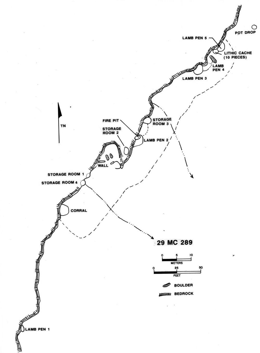 |
Figure 6.17. Plan view of 29Mc 289, a stockholding facility. |
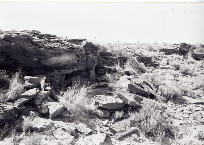 |
Figure 6.18. View of lamb pen at 29Mc 289, a stockholding facility. |
Temporary Shelters
¶ 108 Thirty-three sites in the project area were classified as temporary shelters (Appendix 6.1, Table 8). Each contains the remains of at least one form of temporary human shelter. These shelters vary widely and include rockshelters, shades and windbreaks, features associated with tents, and recycled Anasazi structures.
¶ 109 Twenty-two rock shelters were found at 18 sites. All were constructed of simple sandstone masonry walls, enclosing a naturally sheltered area formed by a rock overhang or boulders. They are often very similar to some of the more crudely constructed hogans (Figure 6.19). No clear distinguishing attributes could be found to separate the two; rather there is a continuum from one type to the other. Even the most crudely constructed hogans, however, tend toward a circular floor plan. Rock shelters always exhibit minimal construction effort and are often elongated rather than circular, or lack any wall outline.
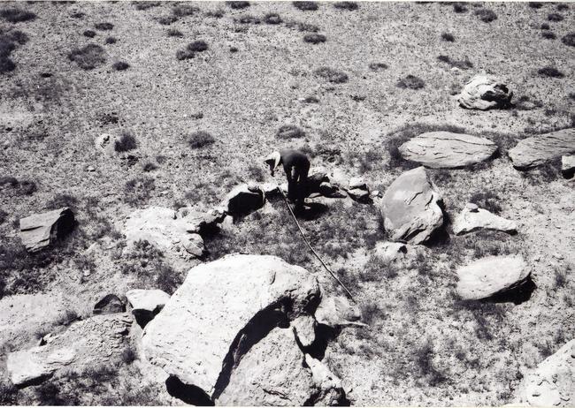 |
Figure 6.19. View of a rockshelter at 29SJ 2792, a temporary site dated to 1930-1960. |
¶ 110 Semi-circular windbreaks or shades of piled brush or stacked sandstone are another common form of temporary shelter and are found at ten temporary shelter sites. Such structures would have provided shade and shelter from wind. When discernible, the openings in these windbreaks were always to the southeast or east. Hearths are sometimes present at the openings of both windbreaks and rock shelters. Scatters of axe-cut wood were also present at two of the shelter sites.
¶ 111 Three temporary shelter sites were probable tent camps. The ethnohistorian recorded a tent fireplace at 29Mc 323 in the Kin Bineola survey area and a tent platform at 29SJ 2837 in the South Addition. Also in the South Addition, at 29SJ 2777, a possible tent platform, located in the center of a corral, was recorded. The tent platform post-dates the use of at least this corral. Three other corrals and a rock shelter were also present.
¶ 112 Abandoned Anasazi structures were used as Navajo shelters at three sites, including an Anasazi fieldhouse, a pueblo room (which was slightly modified by the Navajo occupant), and an Anasazi oven.
¶ 113 Temporary shelters are known to have been constructed by Navajos for sleeping and/or cooking when traveling, herding, hunting, gathering pinyon nuts, or during temporary occupation of a farm, whenever more permanent shelter was not available (Jett and Spencer 1981:35).
¶ 114 Inscriptions at many of these sites indicate that they were used by both Navajo and Spanish-American herders. Name and date inscriptions at 29SJ 2838 (in the South Addition) were made by herders from the Chama Valley of New Mexico between 1881 and 1940. Dates at six other temporary shelter sites fall between 1895 and 1941.
¶ 115 Four temporary shelter sites date to the 1700 to 1863 period, including three rock shelters and a windbreak or shade. Three sites, including a tent camp and two rock shelters were found to date to 1868 to 1930. Nine temporary shelter sites date to 1930 to 1980: three rock shelters, four windbreaks or shades, and two tent camps.
¶ 116 The range of cultural features associated with temporary shelters is very similar to that of the single habitation sites, although storage rooms are rare, being present at only two sites. The features present on temporary shelter sites are summarized in Appendix 6.1, Table 8. Corrals or lamb pens on 11 sites suggest their general use as sheep camps (Figure 6.20). One site had four corrals and two temporary structures. Sites such as this were probably used repeatedly over time, as herders returned to graze in the same areas. Other domestic features include trash scatters, wood cutting areas or piles, hearths, ovens, sherd and lithic scatters, a sweat lodge, a coal mine, a doll house, and a concretion cache. One ash pile was noted at 29SJ 2889, one of the more substantial of the temporary shelter sites; this may indicate that a hogan or tent had been present.
 |
Figure 6.20. View of a brush and stone corral at 29SJ 2608, a temporary shelter site. |
Unidentified Structures
¶ 117 Unidentified structures are the predominant features at nine sites (Table 6.2). Altogether 11 unidentified structures were recorded at these sites, all constructed of stone. Several wall segments which form arcs of simple masonry may be the remains of stone hogans, temporary shelters, or rock shelters. Once again, talus boulders and exposed bedrock often form portions of the enclosures. Sizable scatters of sandstone rubble at three sites also suggest the locations of habitation structures or more substantial shelters. Because these unidentified structures were most likely either hogans or temporary shelters of some sort, the sites probably all served as seasonal or temporary campsites. The presence of domestic features such as outdoor hearths, sherds, trash, and slab scatters at some sites supports this interpretation. One of the larger sites in this category consists of a scatter of rubble from an unidentified structure, a sweat lodge, five hearths, a sherd and lithic scatter, and Navajo rock art. A possible ash pile to the northeast of the structure indicates that it probably was a hogan.
Isolated Hearths/Ovens
¶ 118 Thirty-four sites in the project area consist of isolated hearths or ovens (Table 6.2). Another site included in this category consists of 10 baking pits, although its affiliation with Navajo sherds on the site is unclear. These sites have been classified as temporary campsites because in most cases the hearth was probably used for warmth or food preparation in a temporary camp. Such short-term camps may have been used by hunters, sheep herders, or by various Navajo and Spanish-American groups. The Navajo deer glyphs and possible sweat lodge at 29SJ 2894, for instance, suggest use by a hunting party.
¶ 119 Most of the heart and oven sites have been identified as Navajo or Historic on the basis of associated artifacts. Small amounts of Euro-American refuse and/or Navajo or historic Puebloan sherds are often present. Some hearths have been classified as historic because they appear recent, although no artifacts are present.
¶ 120 Thirty of the sites are hearths and many have associated features, including refuse scatters, firewood stockpiles, rock art, baking pits, areas of fire-cracked rock, trails, roads, storage features, and ash heap/trash piles. The presence of several hearths at some of these sites and a number of associated features indicates repeated use over a period of time and may indicate, in a few instances, more substantial use as seasonal habitations. Early-style Navajo rock art and Navajo ceramics at seven sites in the Chacra Mesa survey area indicate Pre-Bosque Redondo use. Two sites on Chacra Mesa were dated ceramically to A.D. 1600 to 1680, and a third was dated to 1600-1750 (Table 4.13), possibly making them the earliest dated Navajo sites in the Chaco Canyon area.
¶ 121 Several of these early sites, particularly those with two or three hearths, may mark the only remaining surface indications of forked-stick hogans, whose wood superstructure has long since decayed. No hearth sites are dated to the Post-Bosque Redondo Period, 1868 to 1930. Five other small hearth sites contain recent Euro-American trash, dating them to post-1930. This, and their locations along the National Park Service fence line, suggest they were used by fencing crews in the 1940s.
¶ 122 Finally, four of the hearths are suggestive of sweat lodge locations, including the two dating to 1600 to 1680. They also contain fairly large concentrations of fire-reddened sandstone, and two of the four are located by ephemeral drainages, appropriate locations for sweat lodges.4David Brugge (personal communication 2002) notes that there are few indications of Navajo pottery kilns, and suggests that this may be due to misidentification of surface remains. Among the hearths, the best kiln candidates would appear to be sites including fire-cracked rock concentrations, since hearths, both because of their small size and general lack of associated debris seem unlikely to be anything other than their name implies.
¶ 123 Isolated ovens were found at four sites. These are all beehive-shaped masonry ovens with no more than one piece of historic refuse present. They are probably associated with nearby Navajo habitation sites. Another site consists of 10 baking pits. Both Navajo and Anasazi ceramics are present, leaving the cultural affiliation of these baking pits uncertain.
Refuse Scatters
¶ 124 Refuse scatters consist of either Euro-American debris or Navajo sherd scatters with no other associated features. Twelve sites with Euro-American trash were recorded in the Kin Klizhin and Chacra Mesa survey areas. Two of these dated to 1868 to 1930 and six dated to 1930 to 1980 (Table 6.1). One of these also had a single Dinetah sherd present. Six sherd scatters were recorded, all in the Chacra Mesa survey area. All of these were dated to the Pre-Bosque Redondo Period. Most refuse scatters are believed to be the only visible remains of ephemeral campsites, but two others are pot drops and, therefore, probably not indicative of camping. Sherd or Euro-American refuse scatters found in association with trails, wagon roads, or rock art were included in the site types designated by those features, as they probably resulted from the use of those features.
Other Sites
¶ 125 All sites which do not fit into either the habitation site or temporary campsite categories are included here. This category contains the greatest total number of sites, primarily because of the inclusion of a large number (n=72) of rock art sites. In addition, the largest number of site types, 13, are included herein.
¶ 126 “Other” sites were the loci of domestic and production tasks, activities which do not necessarily involve an overnight stay. They include rock art sites, storage facilities, sweat lodges, wood cutting areas, roads and trails, an agricultural field, water control features, a fence line, historic stone quarries, burials, doll houses, and a number of miscellaneous stone features.
Rock Art Sites
¶ 127 Seventy-two of the sites recorded in the project area were categorized as rock art sites: one in the Kin Bineola area, two in the Kin Klizhin survey area, eight in the South Addition, and 61 in the Chacra Mesa survey area (Table 6.2). At these sites rock art, including pictorial designs and/or inscriptions, is the major site feature. Euro-American refuse, sherds, lithics, and trails may also be present. Rock art panels are present at another 72 sites which were included in other site types, making a total of 144 sites with rock art.
Inscriptions
¶ 128 A large number of written inscriptions was recorded in the project area: 221 separate inscriptions at 68 sites. At 30 of these sites, inscriptions were the predominant historic features. The other inscriptions are located at habitation sites, campsites, and other site types in the project area. All four survey areas contain inscriptions, but they are much more numerous in the South Addition and Chacra Mesa survey areas. As has been noted for other areas of Chacra Mesa and Chaco Canyon (Brugge 1981:79, 1986:58), the incised messages found in our project area consist primarily of names or initials, dates, and place names. Most were made by individuals with Spanish surnames; in fact, 91 percent of the 103 names recorded are Spanish (Appendix 6.1, Table 9). Many of these names are repeated at more than one site, recording recurrent visits to the area by the same individuals. The most prolific of these inscribers was Cesario A. Martinez, who left his name or initials 26 times at six sites in the Kin Klizhin, South Addition, and Chacra Mesa survey areas between 1902 and 1942. In one of these inscriptions he also included “Ensenada NM,” indicating his probable home. The names, dates, and home towns recorded indicate most were made by Spanish-American sheep herders. Only a few Anglo names were recorded.
¶ 129 The year of the inscription is indicated 131 times. Dates range from 1881 through 1981, although dates after the 1940s are rare. Twelve nineteenth century dates were present, all probably Spanish-American. Seventy-five percent of the dates fall between 1916 and 1945, with an especially large percentage dating to the 1930s and early 1940s. When the month of the inscription is indicated, wintertime is overwhelmingly represented. Ninety-five percent of the months indicated are from November through April. Only five of the 94 month inscriptions are for May through September, and all but one of those are associated with Anglo-American names. This confirms previous accounts documenting use of the area by Spanish-American herders during winter months. Place names with the Spanish-American inscriptions reveal that many came from villages in the Chama Valley, to the northeast of the project area. Parkview, La Puente, and Canjilon, New Mexico were the most frequently observed place names. Others include Cebolla, San Juan, Jemez, Corrales, Santa Fe, Ensenada, Sandobal, Tirran, Nambe, Chama, Dulce, and Ortiz in New Mexico. Other, probably non-Spanish inscriptions also claimed origins in Colorado, Pennsylvania, and Del Rio, Texas.
Pictorial Rock Art
¶ 130 Pictorial rock art in the project area is both abundant and varied, and like inscriptions, is most profuse in the Chacra Mesa area. In all, pictorial rock art panels were found at 112 sites in the three survey areas. Only in the Kin Klizhin area was none recorded. Designs range from crude scratchings of no apparent meaning to carefully incised or painted human and animal figures. A complete listing of recorded designs is presented in Appendix 6.1, Table 10. Most of this artwork can be attributed to the Navajo, and as Brugge (1981:79) notes for the Chaco Canyon National Monument survey, it spans the full temporal range of Navajo occupation of the area.
¶ 131 Some of the most common representations are Ye'i or Ye'i-like figures, the Navajo deities found in sand paintings. Paintings and etchings of Ye'i are among the earliest rock art designs in the Chaco area (Brugge 1981:79-80; Schaafsma 1984:62). Ye'i figures, as distinguished from dancers or impersonators of Ye'i, are generally considered to date to the eighteenth century (Schaafsma 1984:62). More recent rock art often depicts human participants in ceremonies rather than the gods themselves (Schaafsma 1984:62).
¶ 132 In our project area, it was not always possible to discern whether the Ye'i themselves or the impersonators were represented in the artwork, but Ye'i-like figures were recorded at 26 sites. Most are incised, simple line drawings of Ye'i with rectangular or triangular bodies, upraised arms, and sometimes legs with calves or feet indicating the direction of movement (Figure 6.21). A warrior depicted at 29SJ 2754 carries a bow and quiver with arrows. The figure was both incised and pecked into the rock. A rock panel of Navajo holy people and/or Ye'i is pecked and painted at an early hearth site which was probably used for religious ceremonies (Figure 6.22). A sacred function is also indicated at two other sites: at 29SJ 206 by the presence of numerous Ye'i figures, both incised and painted (Figure 6.23); and at 29SJ 3003 by a long horizontal groove in the cliff face which may have supported an altar. Painted Ye'i figures, as well as other designs, are most often done in red or yellow ocher or in white clay, or a combination of these media.
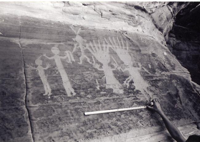 |
Figure 6.21. View of Ye'i figures at 29SJ 2551. |
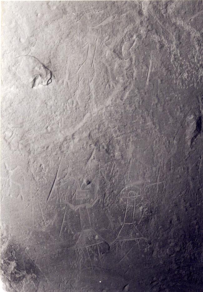 |
Figure 6.22.View of rock art panel of holy people at 29SJ 2653. |
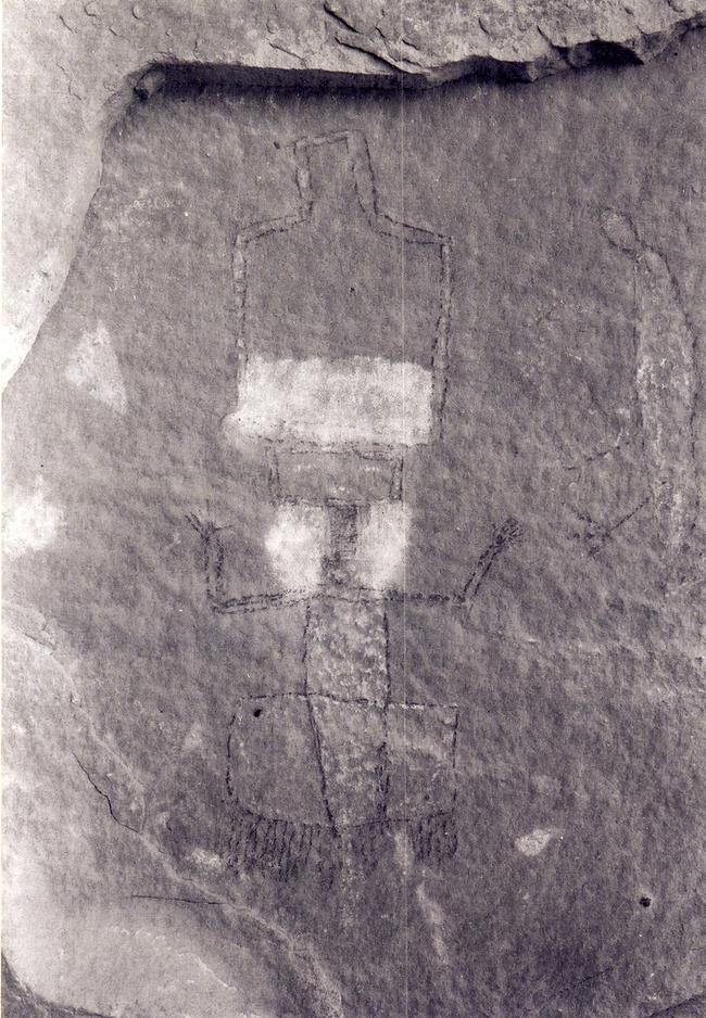 |
Figure 6.23. View of painted Ye'i figures at 29SJ 206. |
¶ 133 Other early rock art designs were found in the project area. Navajo war shields and traditional weapons such as lances and bow-and-arrow are represented. Most are assumed to date prior to 1863, when organized warfare came to an end (Brugge 1981:79-80). Elaborately pecked corn plants at 29SJ 2885 appear to be an early design in keeping with the dates of 1750 to 1850 assigned to this site on the basis of ceramics. Stylized horses, another early art form (Brugge 1981:79-80), were recorded at other sites. At 29SJ 2563, a rock panel of 18 stylized horses, seven with riders, and a large war shield, apparently depict a Navajo or Ute raid from the period of organized warfare, 1800 to 1863. A horseman with bow and arrow chases a deer in a rock panel at 29SJ 2606, another multiple habitation site with a pre-1850 component.
¶ 134 Quadrupedal animals, especially horses, were commonly depicted. Most are incised or pecked and apparently post date 1868. Other more recent rock art designs include rifles, trucks, trains, human figures, and a variety of geometric forms (Appendix 6.1, Table 10). These designs can be assumed to postdate the 1881 arrival of the railroad in western New Mexico. The horses often carry riders, some wearing crowned hats. A scene at 29SJ 2562 depicts a horseman with a rifle chasing a train (Figure 6.24). Deer are also common representations. A series of black painted bulls, one with a red ocher heartline, was also recorded with other pictographs at a post-1930 habitation site (29SJ 2699).
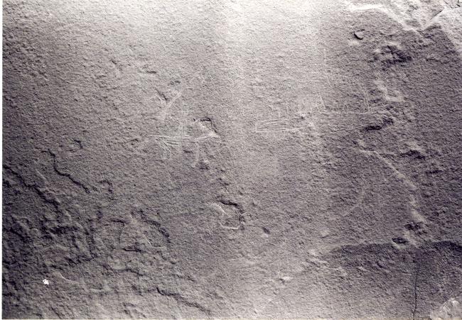 |
Figure 6.24. View of horseman chasing train incised at 29SJ 2562. |
¶ 135 Some less traditional art forms were probably created by Anglo- or Spanish-American herders.
Storage Facilities
¶ 136 Fifteen sites were recorded in which the predominant features were storage rooms (Table 6.2). All but one of these are located in the Chacra Mesa survey area. The other is in the Kin Bineola area. Most storage facilities consist of an isolated storage room with one or two other features. Associated features include Euro-American trash, sherds, lithics, cairns, rock art, burned rubble, hearths, woodpiles, road/trails, rock features and water control features. The storage rooms themselves are almost all constructed by enclosing alcoves or overhangs in the exposed bedrock with simple dry-laid sandstone masonry (Figure 6.25). Only two sites have free-standing storage structures. A third site, 29SJ 2616, has a storage structure built of juniper poles and upright sandstone slabs. Rectangular in plan, this 1.5 by 1.8 m room was dug into the talus slope. Juniper posts form the front and roof; mud and brush are packed on top for weatherproofing.
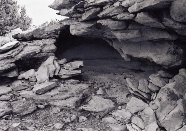 |
Figure 6.25. View of storage room at 29SJ 2649. |
¶ 137 The presence of hearths at four of the storage sites, and a baking pit at another, suggest that some also served as campsites. Most of the storage facilities were probably constructed in association with nearby sites, to take advantage of available sandstone alcoves providing protection from the elements as well as a hiding place from others using the area. Most of these sites appear to have functioned primarily as storage facilities for agricultural products, other foodstuffs, or equipment. The storage unit at 29Mc 499 contained approximately 100 corn cobs and a split wooden tool. Although only one agricultural field was recorded in the project area, others were almost certainly present in the vicinity.
¶ 138 The only two dated storage site components were from the Pre-Bosque Redondo Period, 1700 to 1863, both located in the Chacra Mesa survey area (Table 6.3).
Sweat Lodges
¶ 139 All 20 of the sweat lodge sites recorded are located on Chacra Mesa (Table 6.2). One dates to 1868 to 1930 and five date to 1930 to 1980 (Table 6.1). Two sites contain two sweat lodges each and one contains four. Most consist of the remains of a sweat lodge, an associated rock heating hearth, and a rock stockpile. Occasionally, other features are present, such as storage facilities, hearths, rock art, woodpiles, road/trails, water control features (check dams) and miscellaneous rock piles. Two crude brush enclosures (functions unknown) were found at 29Mc 488. Sherd and lithic scatters and Euro-American refuse were rarely found at sweat lodge sites and on the four sites where refuse did occur, it is limited to very small numbers of artifacts.
¶ 140 The remains of 13 sweat lodges were also recorded at 11 sites previously discussed under other site types. They include six single habitation sites, three multiple habitation sites, one temporary shelter, and one unidentified structure. None of these sweat lodges were standing structures.
¶ 141 Navajo sweat lodges are primarily ceremonial structures. Sweat baths are taken by Navajo men and women for ceremonies, cleanliness, and social contact. Other circumstances include exposure to danger or impurities: warriors returning from a raid, hunters leaving for or returning from the hunt, undertakers after a burial, men before engaging in sex, singers and patients involved in various curing ceremonies, and dancers before the performance (Firebaugh 1981:40; Kluckhohn et al.1971:319). All of the sweat lodges in the project area are located in obscure areas, usually along the lower slopes of an ephemeral drainage, out of sight of any nearby habitation. Their proximity to drainages undoubtedly accounts for the presence of check dams, which were recorded at six of these sites. Both check dams and sweat lodges tend to be located along drainages, although for differing reasons. Cultural affiliation of the check dams is often unknown and they are most likely associated with the sweat lodge sites by accident of location.
¶ 142 Archeological investigations in other parts of northwestern New Mexico indicate that Navajo sweat lodges were generally constructed near a habitation site, for use by its occupants. In the Bisti-Star Lake area just north of Chaco Canyon and in the Black Hat area near Gallup, sweat lodges were generally located within 450 to 500 m of a habitation structure (Firebaugh 1981:82; Kelley 1982b:51). The 20 sweat lodge sites in our project area are all within 350 m of a habitation site, and it is expected that most, if not all, were used in association with one or more nearby sites. Their placement close, but not too close, to the habitation was to minimize the distance blankets and water needed to be carried for the sweat bath, while maintaining enough distance for privacy (Kluckhohn et al. 1971:317-318).
¶ 143 Many of the sweat lodges recorded in the project area are now completely collapsed, consisting of a scatter of poles or branches, sometimes in a slight depression. Two probable sweat lodge locations were discernible based on the presence of fire-cracked rock stockpiles and heating hearths. Of the 12 intact or only partially collapsed sweat lodges recorded, entryways show a strong tendency toward facing east, although south and northeast exposures were also noted. Rock heating hearths are usually within a few meters east of the entryway, with stockpiles of fire-cracked rock often located to the northeast of the entrance. Repeated use of some sweat lodges is clearly evident in the presence of multiple piles of fire-cracked rock and/or the large size of some of those piles, ranging up to 1 m in height and several meters in diameter.
¶ 144 All of the standing sweat lodges are the conical forked-stick type, in which axe-cut juniper and sometimes pinyon poles were used for construction (Figure 6.26). Juniper was used most often in these structures, a preference which W. W. Hill attributed to its not releasing a pungent odor (as does pinyon when heated (Kluckhohn et al. 1971:320). One particularly well-preserved lodge exhibits characteristic 3-pole forked-stick construction, using the forked poles as a frame, with more than 40 juniper leaners forming the walls of the conical structure. As was commonly the case, the floor of this lodge was excavated below the original ground surface. Sweat lodges on Chacra Mesa showed evidence of having been constructed over pits up to 50 cm in depth, often dug into sloping terrain. The poles used in wall construction usually measure between 1 and 1.4 m in length, and formed a structure with an interior space of less than 2 m diameter and approximately 0.75 to 1.2 m in height. In ethnographically observed sweat lodges, the pole walls were covered with brush and then packed earth (Kluckhohn et al. 1971:318), materials which had all washed away from the lodges recorded in our project area.
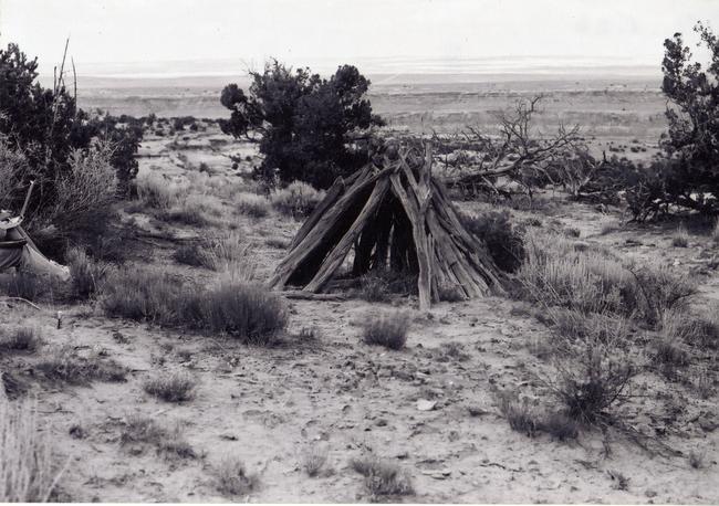 |
Figure 6.26. View of sweat lodge at 29Mc 393. |
¶ 145 Because of their wooden construction, a large number of tree-ring dates was obtained from sweat lodges, providing relatively good chronological information on their construction and use. Ten of the 20 sweat lodge sites produced tree-ring dates (Table 6.11).
|
Table 6.11. Tree-ring dates from sweat lodge sites. |
|
|---|---|
| Site No. | Feature/Outside Ring Datea |
| 29Mc 353 | Sweat lodge: 1914++rGB; Tree near sweat lodge: 1921++rGB |
| 29SJ 1609 | 1871vv, 1900+vv |
| 29SJ 2685 | Sweat lodge: 1909+vv |
| 29SJ 2888 | 1884+v |
| 29SJ 2913 | 1922vv |
| 29SJ 2919 | 1904++GB, 1949vv |
| 29SJ 2950 | 1895vv, 1897vv, 1908vv, 1939++B, 1941+vv |
| 29SJ 2975 | 1795vv |
| 29SJ 2989 | Sweat lodge 1: 1942vv |
| 29SJ 2992 | Sweat lodge 1: 1905++vv, 1922vv; Sweat lodge 3: 1929vv, 1933vv, 1940vv, 1950+vv, 1950+vv |
| aFor explanation of symbols following dates, see Appendix 6.1, Table 2. | |
¶ 146 Although most of these are non-cutting dates, it does appear that most of the sweat lodges were constructed between about 1900 and 1950. An earlier tree-ring date at 29SJ 2888 may be close to a cutting date, but the 1884+v date may simply reflect the time the tree died, not when it was used in construction. Although it is also early, the date at 29SJ 2975 is uninterpretable, given that an unknown number of rings are missing. The 1904 cutting date at 29SJ 2919 is questionable in light of the 1949vv date associated with it; it may be an example of dead wood being used in lodge construction (Tom Rocek 1986:personal communication).
¶ 147 Site 29SJ 2975 contained no standing structures. The collapse and deterioration of its sweat lodge is predictable in light of the feature’s possible antiquity. The sweat lodge at 29SJ 2888, however, is more or less intact, as a result of its being largely buried in a sand dune. Its construction, so far as can be discerned without excavation, indicates no real difference from more recent sweat lodges. In fact, the uniformity exhibited in sweat lodges in the project area suggests greater adherence to ritual during construction and use than in any other type of structure.
Wood Cutting Areas
¶ 148 Nine sites are classified as wood cutting areas (Table 6.2). They are characterized by the presence of small axe-cut wood scatters or piles. Most of the logs or branches are juniper, many of them of a length suitable for either hogan construction or fenceposts. Four of these sites were dated to the Modern period, 1930 to 1980. All appear to post-date 1880. All wood cutting areas are located on top of Chacra Mesa or on its northeastern slope. Kelley (1982a:4), in her analysis of historic sites in the Gallo Wash Mine lease,5The Gallo Wash Mine lease is a 26 section tract of grass and sagebrush plateau located northeast of the Chacra Mesa survey area. It is roughly bounded on the north by the Escavada Wash, on the east by Canada Alemita, on the south by upper Chaco Canyon, and on the west by upper portions of Sheep Camp Canyon and Gallo Wash. identified sites with wood chopping areas and Euro-American trash as Sargent’s herders’ camps, on the assumption that evidence of a tent had disappeared. Informants confirmed this interpretation on at least some of the sites (Kelley 1982a:315).
Roads/Trails
¶ 149 Wagons were introduced into Navajo Country in the mid-1800s by the U.S. government (Kluckhohn, et al. 1971:100) but were not generally available in the Chaco Canyon vicinity until after 1900 (Bailey and Bailey 1982:282). Bailey and Bailey (1982:282) note that 100 wagons were distributed within the Pueblo Bonito agency between 1911 and 1913. Wagon ownership was very common on the northern Chaco Plateau by the early 1920s and wagons continued to be the primary mode of transportation through the 1930s and 1940s (Bailey and Bailey 1982:575-577).
¶ 150 Wagon roads and/or trails were recorded at two sites in the Kin Bineola survey area, one in the South Addition, and 76 in the Chacra Mesa area (Appendix 6.1, Table 1). At 15 sites, the road or trail was the primary site feature (Table 6.2).
¶ 151 Roads are generally assumed to have been constructed and used by Navajo residents. The narrowness and irregularity of road surfaces, particularly those in the broken terrain of the northeastern slope of Chacra Mesa, indicates that they would have been unusable except by horses and wagons.6R. Gwinn Vivian (personal communication 2002) notes that while Navajos using this part of Chacra Mesa for winter camps used only wagons during the late 1940s and early 1950s, his father, Gordon Vivian, “rather regularly” drove a truck up onto Chacra Mesa using a wagon road east of Wijiji. Historic artifacts associated with these roads confirm an early twentieth century time frame.
¶ 152 In the Kin Bineola area, two sites with road segments were recorded. On both of these sites, the road itself was the primary historic feature. Both had been bladed, producing a low berm of rock and earth along the edges.
¶ 153 Most road segments recorded in the Chacra Mesa survey area wind up the northeastern slopes of the mesa from the Chaco Wash. The roads form a maze of interconnected tracks as they ascend to the higher benches of the mesa and eventually reach the mesa top. The eight road segments recorded as road sites are portions of roads which pass through many of the other sites in the project area. Improvements are generally minor. In many of the steeper areas, the roads form switchbacks, with earth cut away from the uphill side and filled along the lower edge. Roughly piled rocks or boulders were used to form retaining walls on the downhill side. Occasionally stones were stacked to form a more definite wall. Ramps were constructed in some rough areas of ascent, or over sudden rises in bedrock, by piling rock in the roadway. Other road segments exhibit piles of stone or rock alignments which have been cleared from the roadway. All of the Chacra Mesa roads were built by hand, with perhaps wagons to haul rock and dirt.
¶ 154 There are two main roads which climb Chacra Mesa from the valley floor of Chaco Wash. These branch out into numerous spurs as they ascend the mesa top, and follow various benches. This road system is concentrated in the central portion of the northeast mesa slope and is clearly associated with several known twentieth century campsites of the family of Choche (particularly 29SJ 2966, 29SJ 2700, and 29SJ 2717). Choche’s descendants probably built these roads to provide wagon access to the trading posts such as Pueblo Bonito, to sources of water or fuel wood, and to permanent camps and sheep camps used by the family.
¶ 155 Segments of trails were the primary feature of five sites in the Chacra Mesa survey area, although trails passed through many other recorded sites. A trail at 29Mc 431 climbs the steep southern scarp of Chacra Mesa and was probably important in herding sheep up and down the mesa. Trails were also often associated with rock art sites. Like roads, trails were generally visible in areas where improvements were necessary to ascend benches, crevices, and cliffs. In steeper areas, rocks are often piled on the downslope side of a trail to slow erosion and possibly to level the surface. Trails which climb bedrock exposures sometimes exhibit man-made hand-and-toe holds or “stairways” formed of stacked blocks (Figure 6.27). Where crevices in bedrock were used for passage, rubble sometimes was used to form a walking surface. Trails were used by Navajo riders, horses, and sheep herders, and probably by other ethnic groups as well. Some appear to have been Anasazi trails, reused by Navajos.
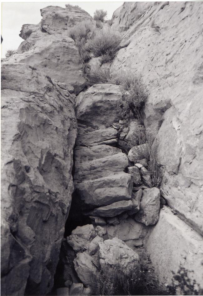 |
Figure 6.27. View of stairway at 29Mc 431. |
Other Sites
¶ 156 Finally, several miscellaneous site types were represented by only a few sites in the project area. These “other” sites include a modern Navajo corn field, four water control features, an old fence line, four quarries, two burials, two doll houses, and 15 miscellaneous stone features (Table 6.2).
¶ 157 The sole modern Navajo agricultural field (29SJ 2449) observed is located in the Kin Klizhin survey area. The corn field was used in the summer of 1976 or 1977 by a son of Ned Benally and was planted for only one or two years before abandonment (Powers 1986:personal communication).7R. Gwinn Vivian (personal communication 2002) notes that this field was established long before the 1970s. Indeed, Navajo farming in the floodplain east of the Kin Klizhin Chacoan structure may date back to the early 1900s or possibly earlier. One of Neil Judd’s Navajo workmen, Dan Cly, insisted that his brother, Clyde Pablo (Bahwola), built the dam and canal first described by Lt. C.C. Morrison in 1876. While Judd discounts this (later testing of the structure by Gordon Vivian and Gwinn Vivian confirmed its Anasazi origin) he did conclude that the dam “should be regarded as a post-1905 Navaho conversion and re-utilization of a P.III irrigation work” (Judd 1954:57). Although no Navajo fields are mentioned by Judd, informant interviews described in Chapter 8 of this volume make it clear that Clyde Pablo farmed here, as well as at Kin Bineola. An earthen dam (29SJ 2444) on Kin Klizhin Wash to the southeast was constructed by bulldozer to divert water to this cornfield. One other earthen dam in the Kin Klizhin area and a check dam in the Chacra Mesa area were also recorded as water control features. A fourth site here classified as a water control feature consists of a stock tank, storage pond, water pump, and salt lick, currently used by cattle ranchers in the Chacra Mesa survey area. An abandoned windmill is also present at that site. Check dams were present at 27 other sites in the project area, although it is not clear whether they were constructed by Navajo or Anasazi occupants. Probably many of them were built by Navajos, some being improved or reused Anasazi dams. They appear to have retained soil and moisture in small plots along ephemeral drainages, and were probably used for planting scattered crops. The abundance of storage features at Navajo sites in the project area also suggests that small farm plots were planted in the area and generated enough agricultural produce to require storage. As discussed in Chapter 3, there is historic evidence of successful crop production, especially around Kin Klizhin and Kin Bineola (Judd 1954:51-59). An old fence line in the South Addition, 29SJ 2836, represented by two cairns and four rock anchors with barbed wire fencing wrapped around them, may have enclosed another agricultural field.
¶ 158 Four sandstone quarry sites were recorded, one in the Kin Klizhin survey area and three on Chacra Mesa. Three of them contain additional features unrelated to quarrying activities. All four sites consist of outcrops with shattered rock debris. Wagon road segments are associated with two of these sites. A third contains a small circular masonry structure, a doll house, and a cairn. Quarried materials were most likely used for construction of nearby hogans and other masonry structures. Quarrying debris is also present at two habitation sites and possibly one sweat lodge site in the Chacra Mesa survey area. In addition, two clay quarries were noted at multiple habitation sites.
¶ 159 Two sites in the Chacra Mesa survey area were recorded as Navajo burial sites. In addition, seven other possible burials were recorded at other types of sites in the project area. Because survey crews did not wish to disturb the potential burials, their identification remains uncertain. However, each exhibits characteristics of traditional burial practices. One of the burial sites, 29SJ 2556, also contains part of a doll house and several red ocher hand prints on a sandstone cliff. The burial at that site was suggested by a corn husk bundle and a broken Dinetah vessel (ca. 1700 to 18508See endnote 2 for the revised production dates of Dinetah Gray.) located in an overhang. A large boulder and numerous stacked small slabs with brush and grass backed around them conceal the interior of the overhang. The other burial site (29SJ 2902), also in an overhang, consists of a dry-laid masonry crypt covered with juniper branches and rock. It measures 2.5 by 1.4 m and is 0.5 m high. Other possible burials were recorded at one multiple habitation site, three single habitation sites, one unidentified structure site, one stockholding facility, and one temporary shelter. The possible burials recorded at these sites also are located in sandstone ledge crevices which have been sealed with sticks and/or stacked slabs (Table 6.12). Historic burials of this type are noted by Keur (1941:65) and Malcolm (1939:16). Jett and Spencer (1981:205) also note that Navajo “corpses are commonly placed in crevices in rocks and cliffs or gullies, or under talus boulders, and sealed with loose rocks, earth, and/or sticks or brush, to protect the body from coyotes and other scavengers.” Several possible open burials which had been covered with rocks and/or wood were also noted in this project area. Such covered surface burials are also traditional to Navajos (Jett and Spencer 1981:205). An upright wooden post, as found at 29SJ 2536, may also have been used to mark the location of a grave (Jett and Spencer 1981:206). Burials were found in all survey areas except the South Addition.
Table 6.12. Burials recorded in the project area.
¶ 160 Doll houses were the predominant features at two sites, both in the Chacra Mesa survey area. At one, 29Mc 462, two miniature masonry hogans were present, one 60 by 50 cm and the other 47 by 35 cm. The other doll house site, 29SJ 2955, contains the remains of 12 or 13 miniature hogans and rectangular houses associated with two hearths, two rock piles, a check dam, and a Navajo sherd scatter. The doll houses at this site consist of partially collapsed circular enclosures of piled slabs and spalls. Other doll houses are present at seven previously described sites. All are similar is size and construction (Figures 6.28 and 6.29). That these small masonry enclosures are the remains of doll houses is not absolutely certain. Those in the Chaco Canyon area have previously been interpreted as play houses (Brugge 1981:78). One doll house with miniature furnishings still inside is known within the former Monument (Dabney Ford 1985:personal communication). Some enclosures of this sort may have served other purposes, however. Those which were large enough for a man to fit inside and located on prominences may have served as eagle traps, a feature which Navajo informants indicated was used in eagle hunting on Chacra Mesa (Fred York 1985:personal communication).
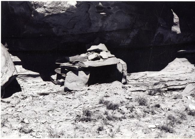 |
Figure 6.28. View of doll house at 29SJ 2709, a post-1950 temporary shelter site. |
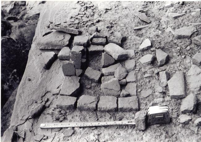 |
Figure 6.29. View of rectangular doll house at 29SJ 2556. |
¶ 161 A final site type includes fifteen sites with an array of miscellaneous stone features which do not fit into other previously described sites types. With some exceptions, their functions are unclear. They include two sites with rock cairns, one mealing bin, a concretion cache, a slab platform which was probably used as a shelf or stove platform in a tent, a D-shaped structure with sandstone masonry, six rock alignments or walls, and three sites consisting of slab scatters (Table 6.13). Other features present at these sites are hearths, rock art, and historic sherd scatters.
Table 6.13. Miscellaneous stone feature sites.
Testing the Site Typology
¶ 162 The site typology established here for historic and Navajo sites was devised to separate the sites into functionally distinct classes relying only on archeologically observable attributes. The primary, or predominant, cultural features of each site were used to determine into which of the 21 site types a particular Navajo or historic site was placed. Thus, the site types are basically morphological in nature although it is believed that they are also, for the most part, functionally distinctive. In this section, I will assess the value of the typology as a tool for accurately distinguishing significant functional differences between the major Navajo site types and the site type groups into which they have been placed.
¶ 163 Five major site types were defined: 1) multiple habitations, 2) single habitations, 3) temporary shelters, 4) stockholding facilities, and 5) isolated ovens and hearths. Multiple habitations were defined by the presence or two or more hogans; single habitations by one hogan, temporary shelters by the presence of rockshelters, shades and windbreaks or features associated with tents; stockholding facilities by corrals or lamb pens, and ovens/hearths by the presence of ovens or hearths. It is important to note that these morphological features are independent of the attributes used in the following pages to evaluate the typology.
¶ 164 Each of the five site types will be examined for validity as distinct functional groups. They are merged into two site type groups, the single and multiple habitations forming the habitation site type group; while temporary shelters, stockholding facilities, and isolated ovens and hearths compose the temporary camp site group. Three other site types in the temporary camp group (unidentified structures, ceramic scatters, and Euro-American refuse) contained too few sites to be considered major site types.
¶ 165 Finding an appropriate test for differences between the major site types is difficult for two reasons. Although the items disposed of on a site do provide insight into the activities which occurred there, studies have shown that they do not necessarily provide an accurate view of the primary site function. For example, Binford (1978:335) has shown that at aboriginal game watching sites in Alaska one finds no direct evidence of the primary activity (i.e., watching for game); rather, the artifacts recorded on those sites are a byproduct of flintknapping, an activity engaged to kill time.
¶ 166 Similar observations have been made on Navajo sites in northwestern New Mexico. Kelley (1982a:342) and Wozniak (1983:329) have shown that the artifacts recorded on Navajo camps contain little to no direct evidence of the importance of stock raising, although ethnographic information clearly shows stock raising to be of major importance to the Navajo economy. Klara Kelley (1982a:342) suggests that more information is derived by observing the facilities present at the sites, where the importance of livestock production is indicated by corrals, pens, or barns. Facilities such as these, while providing direct evidence of the productive activities occurring on Navajo sites, cannot be used as an independent test of the usefulness of the typology because these features were used to distinguish the different site types in the field.
¶ 167 An independent means is provided, however, by using the artifacts and certain features to contrast and compare the different site types and groups. This can be done without inferring specific functions from those artifacts or features.
¶ 168 The primary distinction between habitation sites and temporary camps is the differing length of occupation. Habitation sites, although often seasonal in use, were generally built for long-term occupation and were considered to be a permanent residence for a Navajo family. A temporary camp, on the other hand, is generally “occupied by only a portion of the family on a short-term basis to exploit a short-lived, economically important phenomenon” (Bailey and Bailey 1982:337). Occupation of a temporary camp is generally limited to only a few days (Bailey and Bailey 1982:337). In general, length of occupation should differ between all five major site types, with multiple habitation sites having generally more long-term occupations, followed by single habitations, temporary shelters, stockholding facilities, and finally, hearths or ovens.
¶ 169 It is assumed here that sites characterized by a greater length of occupation should also exhibit a greater variety of activity. This should be reflected by a higher frequency and variety of artifacts in assemblages at habitation sites as compared to temporary camps. Overall artifact assemblage size and variability should decrease from multiple habitations through the other four site types.
¶ 170 In addition, items of relatively long use, particularly heavy or bulky items such as stoves and many other domestic items, are less likely to be worn out and deposited at temporary campsites, because these sites were occupied for short intervals.
¶ 171 Because of the increase in activities outside the house which would accompany a longer annual stay, it is also expected that a greater number of outside features will occur at habitation sites. Kelley (1982b:69-71) has previously verified this expectation in the Black Hat area of New Mexico, where homesteads tended to have more dwellings and corrals than sheep camps, as well as more of most other common features, including windbreaks, ramadas, sweat houses, ovens, ash dumps, woodpiles, and storage features. If the particular features which were used in identifying our site types are excluded, several features remain: beehive ovens, storage structures, and ash and/or trash piles. Logically, beehive ovens and storage structures would be more likely to occur at habitation sites than temporary camps because the time invested in their construction would be wasted at sites where the length of occupation was very short. Ash and trash piles or scatters would accumulate more often at sites of longer occupation than at temporary camps. Ash and trash piles have not been separated from one another here because they are often found combined or overlapping on sites and because they were not always distinguished from one another.
¶ 172 Finally, one would expect a greater number of different features to be present on habitation sites than on temporary camp sites, as a result of the greater range of activities presumed to have occurred at sites occupied for a longer period during each year.
¶ 173 In summary, if habitations and temporary camps as defined in the site typology do represent distinct functional groups, the following differences should be found:
- 1) A larger quantity and a greater variety of refuse will be present on habitation sites than on temporary camps.
- 2) Heavy or bulky items, or those with relatively long use lives, will be more heavily represented on habitation sites than on temporary camps.
- 3) Beehive ovens, storage structures, and ash and/or trash piles will tend to be associated with habitation sites rather than temporary camps.
- 4) A greater variety of feature types will be associated with habitation sites than temporary camps.
Artifact Numbers and Variety
¶ 174 The first of these expectations was tested using data from three categories of artifactual remains: lithics, ceramics, and Euro-American refuse. Two types of information were gathered for each category: the total number of artifacts observed on sites in each group, and the number of different artifact “types” observed.
¶ 175 The number of lithic artifact types at each site corresponds to the lithic flake and tool types recorded by lithic analysts in the field. The 15 possible lithic artifact types include: projectile point, scraper, biface, drill, ground stone, hammertoe, core, utilized/retouched flake, primary flake, secondary flake, angular debris, biface thinning flake, mineral, ornament, and other artifact.
¶ 176 Ceramics were divided into three possible types: decorated bowls, plain bowls, and plain jars. Historic artifacts were divided into 11 material/functional types, following Wozniak (1983:322):
- 1) Food: All food or beverage containers, including medicines.
- 2) Food preparation: All implements for the preparation, serving, and storage of food.
- 3) Personal items: All small personal or adornment items, particularly those that can be carried in a pocket or purse, including tobacco containers and grooming implements.
- 4) Lighting, temporary shelter, and heating items: Items related to light sources (e.g., lantern parts), tent stakes, and fragments of iron stoves.
- 5) Construction: Items or materials used in the construction of shelters, fences, or other structures.
- 6) Weapons: Cartridge casings.
- 7) Transportation: Items which provide evidence of the use of horses, wagons, cars, trucks, or bicycles.
- 8) Work and play activities: Items which indicate work (particularly animal husbandry-related artifacts) or recreational (e.g., toys) activities.
- 9) Clothing: All wearing apparel, including shoes.
- 10) Other: All items that either do not clearly fit into the above groups or that have multiple applications.
- 11) Unidentified: All items for which information was insufficient to make a functional designation.
¶ 177 Combining artifact groups from all three categories, a total of 28 artifact types are possible. Category 11 of the historic artifacts was not considered a distinct functional category for purposes of this analysis. The most artifact types recorded for one site was 18, at 29SJ 2966. This site, a multiple habitation site, also had the largest overall number of artifacts recorded. Most sites examined for this analysis, in both the habitation site and temporary camp groups, contained fewer than three separate artifact types and fewer than five total artifacts. Figure 6.30 graphically illustrates the differences between the number of artifacts recorded at the five major site types. With the exception of multiple habitations the majority of sites of all types contained no artifacts. The graphs for single habitations, temporary shelters, stockholding facilities, and hearths are all similar, while that for multiple habitation sites differs substantially. The difference between multiple habitation sites and the other four site types is even more pronounced in the number of artifact groups observed, as illustrated in Figure 6.31.
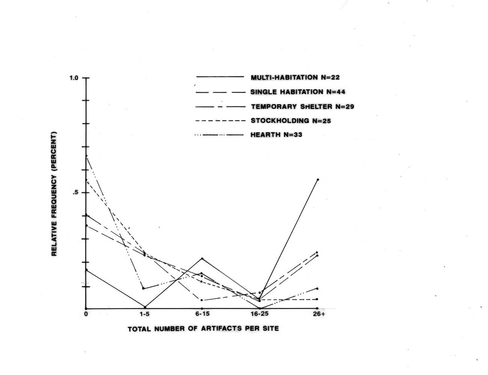 |
Figure 6.30.Variation in the total number of artifacts observed at major site types. |
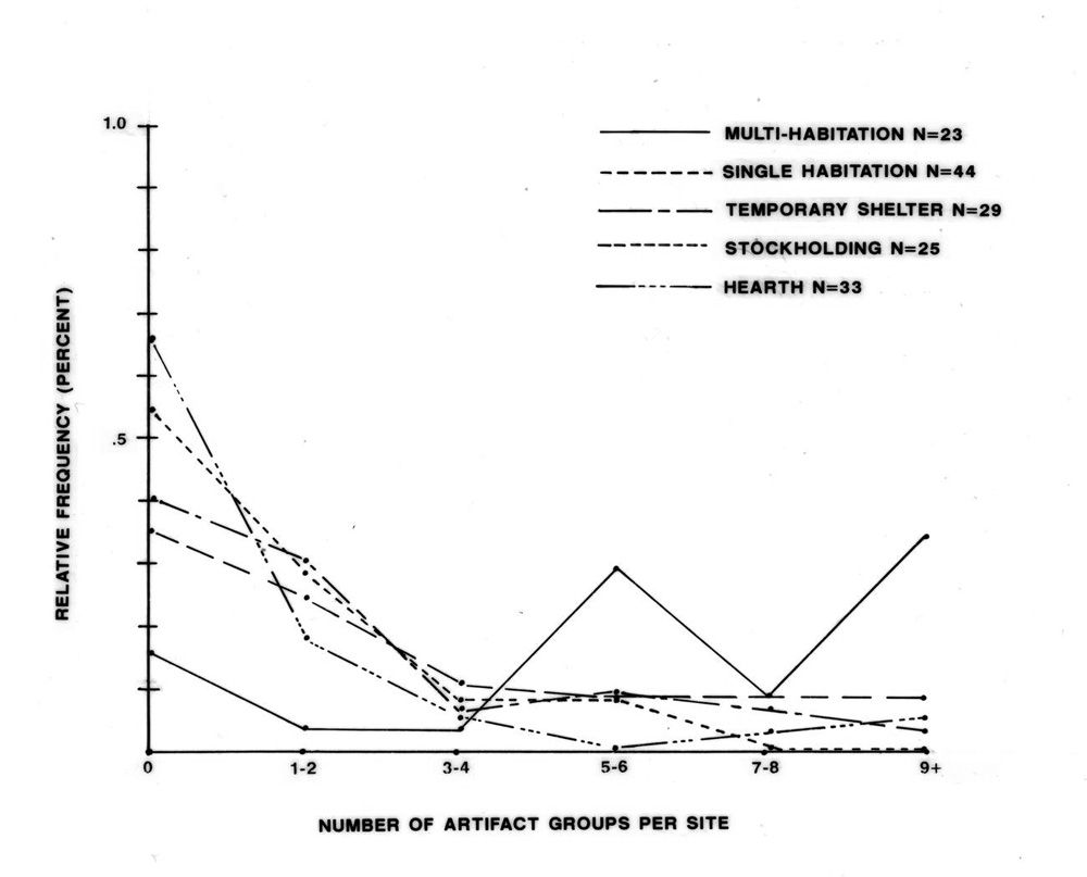 |
Figure 6.31. Variation in the number of artifact groups observed at major site types. |
¶ 178 A Brainerd-Robinson Correlation Coefficient (C=200-∑|x-y|) was used to compare the five site types for both number of artifacts observed and number of artifact groups. With Brainerd-Robinson, when two graphs are completely different, the correlation coefficient will be 0. If the graphs are identical, the coefficient is 200. The calculated correlation coefficients are presented in Tables 6.14 and 6.15.
Table 6.14. Brainerd-Robinson Correlation Coefficients for total number of artifacts.
Table 6.15. Brainerd-Robinson Correlation Coefficients for number of artifact groups.
¶ 179 It is apparent that in both cases the greatest similarity exists between single habitation sites and temporary shelters, with a correlation coefficient of 179 for number of artifacts and 176 for number of artifact groups. This suggests that the length of stay at these two site types was most similar. In fact the correlation coefficient indicates that they are more alike than are single habitations and multiple habitations. This suggests that the majority of single habitation sites functioned more like temporary campsites than multiple habitations. In this respect, the relative lack of differences in the artifact assemblages of single habitation sites and temporary shelters does not strongly support the separation of the former site type from temporary campsites, or its inclusion in the habitation group category. Nonetheless, some single habitation sites do have substantial numbers of artifacts and artifact groups, and are accordingly more like multiple habitations. From the perspective of artifacts, it appears that single habitations include sites with a range of assemblages, extending from those similar to multi-habitations to those indistinguishable from the assemblages of temporary shelters.
¶ 180 In Tables 6.14 and 6.15, for all site types, the lowest level of correlation is always found with multiple habitation sites. Thus, multiple habitation sites are shown to be most distinct from all other site types.
¶ 181 With this sort of analysis, potential temporal changes in site use should be controlled for, and if possible, the analysis should be conducted by time period. Unfortunately, this could not be accomplished with the present data due to small sample sizes (when the five site types were broken down by time period), and an inability to distinguish assemblages from separate components at multi-component sites. However, to address this potential problem, the mean number of artifacts and, then, the mean number of artifact groups were calculated for each major site type by time period (Tables 6.16 and 6.17).
|
Table 6.16. Mean number of artifacts for each major site type by time period. |
||||||||
|---|---|---|---|---|---|---|---|---|
| 1700-1863 | 1868-1930 | 1930-1980 | ||||||
| No. | x̅ | No. | x̅ | No. | x̅ | |||
| Multiple Habitations | 7 | 70 | 3 | 50 | 6 | 250.3 | ||
| Single Habitations | 7 | 31.3 | 10 | 12.9 | 2 | 11.5 | ||
| Temporary Shelter | 4 | 27.8 | 1 | 10 | 7 | 12.3 | ||
| Stockholding | - | - | 2 | 0.5 | 3 | 9 | ||
| Oven/Hearth | 7 | 36.6 | - | - | 3 | 2 | ||
|
Table 6.17. Mean number of artifact groups for each major site type by time period. |
||||||||
|---|---|---|---|---|---|---|---|---|
| 1700-1863 | 1868-1930 | 1930-1980 | ||||||
| No. | x̄ | No. | x̅ | No. | x̅ | |||
| Multiple Habitations | 7 | 4.3 | 3 | 9.0 | 6 | 8.5 | ||
| Single Habitations | 7 | 4.4 | 10 | 3.5 | 2 | 4.0 | ||
| Temporary Shelter | 4 | 2.2 | 1 | 4.0 | 7 | 3.7 | ||
| Stockholding | - | - | 2 | 0.5 | 3 | 2.7 | ||
| Oven/Hearth | 7 | 4.7 | - | - | 3 | 1.0 | ||
¶ 182 Tables 6.16 and 6.17 include only those sites for which artifact associations by component were fairly certain and, therefore, totals (n) are often quite low (lower than the number of sites known to date to each period). As such, many of the mean values are based on very small numbers of observations and should be viewed with caution. The tables indicate that some temporal variation did occur in both mean number of artifacts and number of artifact groups. The mean number of artifacts is highest during the 1700 to 1863 period for all site types except multiple habitations. Multiple habitation sites show a possible increase in the mean number of artifacts and number of artifact groups during the 1930 to 1980 period. Despite the small sample, this data tends to support the previous finding that multiple habitation sites exhibit the most substantial difference in artifact assemblage of the five site types, containing larger numbers of artifacts (for all time periods) and a larger number of artifact groups after 1863. The other four site types are generally similar, especially single habitations and temporary shelter sites.
¶ 183 The examination of the numbers and variety of artifacts at sites, therefore, suggests that the habitation site and temporary camp site groups are not entirely distinct, although multiple habitation site assemblages are most different from those of other site types. The other four major site types are similar in the numbers and variety of artifacts observed.
Heavy or Bulky Items
¶ 184 Heavy or bulky items recorded at Navajo and Historic sites in the Chaco Additions include the following: anvils, axe heads, barrel hoops, buckets, cooking ware, harnesses, iron stoves, machinery, rebar, shepherd’s stoves, shovels, steel drums, stove pipes, tires, trash cans, troughs, wagon parts, and wire spools. Although groundstone, especially metates, are considered heavy or bulky, none were recorded on the Navajo or historic components. In all, 32 sites contained heavy or bulky artifacts: 12 multiple habitations, 8 single habitations, 2 temporary shelters, 1 stockholding facility, 1 hearth site, and 8 sites not included in the present analysis (Appendix 6.1, Table 11). On a proportional basis, heavy or bulky items are present on 40 percent of the multiple habitations, 16 percent of the single habitations, 6 percent of the temporary shelters, 4 percent of the stockholding facilities, and 3 percent of the hearth/oven sites. There is an apparent decrease in the proportion of heavy/bulky items as the expected length of occupation decreases.
¶ 185 From the perspective of the site type groups, 25 percent of the habitation sites (including multiple and single habitations) contained heavy/bulky artifacts, while only 4 percent of the temporary campsites (including temporary shelters, stockholding facilities and hearths) do. A Chi-Square Two Sample Test (Siegel 1956) comparing habitation sites with temporary camps for the presence/absence of heavy or bulky items indicates that this difference is significant (χ2 [1,n=32]=15.86, p<0.001). Differences in the numbers of sites with heavy or bulky items therefore suggest that habitations and temporary camps are functionally distinct.
Features
¶ 186 Beehive ovens, storage features, and ash/trash piles were expected to occur more frequently at habitation sites than at temporary camps. To test this assumption, the number of sites from each site type group with these features present was determined, and a Chi-Square Two Sample Test (Siegel 1956) comparing habitations and temporary camp sites was computed for each of the three feature types (Table 6.18). In these tests, oven/hearth sites were excluded from the temporary campsite category. This was necessary because by definition oven/hearth sites contain no storage features, oven sites all contained beehive ovens, and both oven and hearth sites are unlikely to contain ash/trash piles.
|
Table 6.18. Number of sites with beehive ovens, storage features, and ash/trash piles present. |
|||||
|---|---|---|---|---|---|
| Habitation Sites (n=80) | Temporary Campsitesa (n=60) | Chi-square | p | df | |
| Beehive Ovens | 9 | 1 | 4.7 | <0.05 | 1 |
| Storage Features | 38 | 10 | 14.4 | <0.001 | 1 |
| Ash/Trash Piles | 32 | 3 | 22.4 | <0.001 | 1 |
| aIncludes temporary shelters and stockholding facilities only. | |||||
¶ 187 In all cases, the difference between the two site type groups is significant, at less than a .05 level of significance. This suggests that the two are distinct groups in terms of the presence/absence of these three features: that habitation sites, as a group, contain more beehive ovens, storage features, and ash/trash piles than do temporary camps. This test, therefore, supports the division of sites into the two groups.
Feature Variety
¶ 188 To determine the range of features present at each of the two site groups, the number of feature types for each site was tallied. Feature types included in this analysis were restricted to the major features observed at sites and were taken from those listed in Appendix 6.1, Table 1. They are as follows: hogan/house, corral/lamb pen, rock feature, wood pile/feature, temporary shelter, storage feature, hearth/oven, water control feature, unidentified structure, sweat lodge, ash/trash pile, and road/trail. Excluded from this list were rock art panels, because for many of the habitation sites contemporaneity was in question.
¶ 189 The number of different features observed on sites ranged from one to 11. Three site types were compared for feature variability: multiple habitations, single habitations, and temporary shelters. These three were chosen because they posed the biggest challenge to the typology and I wished to further examine the possibility that they were not separate functional classes. For these three site types, the range in features was quite similar. Multiple habitations contained from one to 10 recorded feature types, single habitations contained from one to 11, and temporary shelters contained from one to seven. Because feature variety is not distributed normally, the non-parametric Mann-Whitney U Test (Siegel 1956) was used to test for a significant difference between, first, the two habitation site types, and then, between single habitations and temporary shelters.
¶ 190 Comparing multiple and single habitation sites, a one-tailed Mann-Whitney U Test produced a z value of 2.70, p=0.003 indicating that the variety of features observed on these two site types is significantly different. Comparing single habitations and temporary shelters, the Mann-Whitney U Test also indicated a significant difference in feature variety, with a z value of 1.87 ( p=0.0314). This supports the separation of multiple habitations, single habitations, and temporary shelters into separate site types, with multiple habitations exhibiting a greater range of features than single habitations, and single habitations having a greater range of features than temporary shelters. It also suggests that single habitation sites exhibit less similarity to multiple habitation sites than to temporary shelters, in terms of the variety of features present. The site type distinctions are, therefore, supported, although a similarity between single habitation sites and temporary shelters is again suggested.
Conclusions
¶ 191 The preceding tests have provided variable results, but in general support the validity of the typology. Artifact numbers and variety differ most clearly between multiple habitation sites, which have a much greater number and variety of artifacts, and temporary campsites (including temporary shelters, stockholding facilities and hearths) which do not have large numbers of artifacts or a wide range of artifact groups. This test also suggested that the assemblages of single habitation sites, while generally resembling those of the temporary campsite group, also include sites whose assemblages are like those of multi-habitations. This range of variation suggests that single habitations include a mixture of sites ranging from those occupied over relatively long periods of time to those inhabited for much shorter intervals.
¶ 192 A somewhat different perspective is provided by the occurrence of heavy and bulky artifacts. A Chi-square test indicated that habitation sites (including both multiple and single habitations) and temporary camps are valid groups, with the habitation site group containing significantly more heavy and bulky artifacts than temporary camps. In addition, the number of sites with heavy or bulky items decreases as the expected length of occupation for each site type decreases, indicating that the five site types are also functionally distinct.
¶ 193 The presence of beehive ovens, storage features, and ash/trash piles—three categories of features expected to indicate greater length of occupation—also differs between the two site type groups, with significantly more of all three feature types occurring at habitation sites than at temporary camps.
¶ 194 Feature variety also varies significantly between multiple habitations, single habitations, and temporary shelters, the three site types which are most similar morphologically. The greatest variety of features were observed on multiple habitations; single habitations exhibited less diversity, and temporary shelters had less feature variety than either habitation site type.
¶ 195 Like the test for artifact numbers and variety, the feature variety test indicated that single habitations and temporary shelters were more similar. It should be noted that many of the more crudely constructed hogans, for which the only remaining evidence is a low ring of stone against an outcrop or boulder, were very similar to structures recorded as rock shelters (one of several types of temporary shelters). The primary distinction being that the former were curvilinear in plan and the latter tended to be rectangular or of irregular shape. These two site types are probably not completely distinguishable from one another and in some cases sites from both types probably functioned in a very similar manner.
¶ 196 On a general level the tests support the site typology, indicating that the major site types and site type groups are functionally, as well as morphologically, distinct. The discovery that single habitations and temporary shelters were more similar by some measures, suggests substantial functional variation and differences in duration of use within the single habitation site class. In some respects this class of sites appears transitional between multiple habitations and temporary camps.
Settlement Patterns
¶ 197 Previous research in the Navajo occupation of the Chaco region has provided us with a great deal of information concerning subsistence and productive pursuits and how changes in the economy in the last 100 years have altered Navajo lifestyles and land use. In a very general manner, this information has been summarized in the preceding “Historic Overview.” In this section of the chapter, the archeological remains recorded in the four additions to Chaco Culture National Historical Park will be examined to ascertain how well the archeological record supports that description of Navajo economy and land use patterns. Of primary interest here is the way in which sites are distributed across the landscape and how this distribution changed through time. By defining the settlement patterns of the Navajo who lived in the area of the four additions, a better understanding of the settlement system within which they operated can be attained.
¶ 198 The difficulty in analyzing Navajo settlement patterns within the four survey areas is that each of these areas have arbitrary boundaries, and individually are far too small to encompass an entire settlement system. The habitations and camps in each of these additions account for only a small portion of the area utilized by any particular family: even combining all four areas does not provide an area adequate to encompass the entire seasonal range of any family. As was noted in the historic overview, families utilizing Chacra Mesa during the winter generally moved with their herds north in the summer, to areas along the Escavada and Gallo washes (Kelley 1982a:197). As such, this analysis must rely on information gathered by ethnohistorians and on archeological data from the surrounding region in order to dependably interpret the findings.
Seasonality
¶ 199 Historically, Navajo families moved seasonally with their livestock to various grazing areas according to range conditions and the availability of water (Bailey and Bailey 1982:336; Brugge 1980:30). In order to examine the sites in the four survey areas for evidence of seasonality, ethnographically observed differences between summer and winter camps were used. At Navajo summer camps, dwellings generally consist of shades, ramadas, or tents, rather than hogans (Bailey and Bailey 1982:338; Kelley 1982a:342; Reher 1977:39; Winter 1983:485). Directly associated corrals are often lacking and, when present, are of light weight construction. Since 1920 they have been generally constructed of wire (Bailey and Bailey 1982:338; Kelley 1982a:239; Reher 1977:39). Sheep were also bedded in the open in summer, a practice likely to leave little, if any, archaeological evidence. Summer camps are often located in areas open to cooling breezes (Bailey and Bailey 1982:338).
¶ 200 In contrast, the most important structure at a winter camp is the sheep corral, generally constructed of heavy posts or stone and substantial enough to protect stock from blizzard conditions (Bailey and Bailey 1982:338; Kelley 1982a:239). Winter camps tend to contain hogans for dwellings and are in protected locations (Bailey and Bailey 1982:338). Although some summer habitation sites may have also used hogans, as well as stone and brush corrals, the general pattern of seasonality should reflect the above differences. It follows, therefore, that if the Navajo occupation of the four survey areas was primarily during the winter, most habitation sites (greater than 50 percent) would contain hogans and heavy corrals constructed of wood and/or stone, and be located in protected areas.
¶ 201 Because habitation sites as a category were restricted to sites with hogans or houses most summer habitations were probably excluded from the habitation category and are more likely to be found among temporary shelter sites. For this analysis, therefore, temporary shelter sites were included, along with single and multiple habitation sites. Table 6.19 summarizes the occurrence of two winter diagnostic attributes, corrals and protected locations, at these three site types.
|
Table 6.19. Attributes indicating winter use at habitation and temporary shelter sites. |
|||
|---|---|---|---|
| Survey Area | No. of Sites | Sites with Corrals | Sites in Protected Areas |
| Kin Bineola | 13 | 6 (46%) | 12 (92%) |
| Kin Klizhin | 8 | 6 (75%) | 8 (100%) |
| South Addition | 13 | 9 (69%) | 13 (100%) |
| Chacra Mesa | 78 | 28 (36%) | 71 (91%) |
| Total | 112 | 49 (44%) | 104 (93%) |
| Note: Percentages shown in this table represent the proportions of sites in a given area that have corrals or are located in protected areas. For example, at Kin Bineola six of the 13 sites have corrals (46 percent) and 12 of the 13 sites (92 percent) are in protected locations. | |||
¶ 202 Sites were considered to be located in protected areas if they were situated against sandstone cliffs or ledges, or in rincons which afforded protection from the wind, regardless of their directional orientation.
¶ 203 Table 6.19 shows that 93 percent of the habitations and temporary shelter sites in all four areas are in protected areas. A majority of these sites in the Kin Klizhin and South Addition survey areas also contain animal enclosures. For Kin Klizhin and the South Addition, therefore, winter occupation is suggested.
¶ 204 At Kin Bineola, however, just 46 percent of the sites contain animal enclosures, and in the Chacra Mesa survey area corrals are found at only 36 percent of the habitations or temporary shelter sites. This in itself might indicate that these areas were primarily occupied in the summer, but the low number of sites with corrals or lamb pens is offset by the fact that the corrals which were recorded in these areas (as well as in Kin Klizhin and the South Addition) are almost all constructed of heavy materials—brush and stone, often using large boulders and sandstone outcrops to form part of the enclosure. In fact, evidence for post and wire corrals was found at only five (4 percent) of the habitation or temporary shelter sites. The small percentages of sites in the Kin Bineola and Chacra Mesa survey areas with corrals or lamb pens may also be explained by the fact that rincons were heavily used as enclosures, requiring little additional construction and in some instances leaving little evidence behind. Many isolated corrals were also recorded (as stockholding facilities—see Table 6.2). These also tended to be constructed of heavy materials, suggesting winter use.
¶ 205 The occurrence of shades, ramadas, and tents at temporary shelter sites indicates that some summer use occurred at all four survey areas. Given that the remains of light weight corrals and summer type dwellings are more inclined to vanish with time, it seems likely that summer habitations are under represented in the survey sample.
¶ 206 Seasonal movements of the Chaco Navajo have been documented ethnohistorically for the late nineteenth century through the early 1950s (Kelley 1982a:197-227; Chapter 8, this volume). Chacra Mesa is known to have been used for winter range during that time by a number of families who moved north to the sage and grass plains along the Gallo and Escavada washes during the summer season (Kelley 1982a:197).9R. Gwinn Vivian (personal communication 2002) notes that Navajos continued to use hogan sites on Chacra Mesa as winter residences during the early 1950s. Although the Monument had been fenced, families were allowed to drive their herds and wagons through the Monument to reach their residences. In addition, summer occupation of Chacra Mesa has been documented at the Doll House Site (Brugge 1986:134).
¶ 207 Navajo informants have verified winter occupation of several habitation sites in the Chacra Mesa survey area (29Mc 391, 29SJ 2700, 29SJ 2885, 29SJ 2908, and 29SJ 2966) and on top of South Mesa (York: field notes). Numerous summer agricultural fields were located in South Gap to the west of South Mesa, as well. Year-round occupation also occurred in the Kin Klizhin survey area, at 29SJ 2471. For the Kin Bineola and Kin Klizhin survey areas, York (field notes) suggests that seasonal use varied through time, from year-round use to winter use when land was acquired in the upper Kin Bineola valley.
¶ 208 In summary, there is archeological evidence of both winter and summer occupation or use of the four survey areas. Winter habitation is suggested by the presence of hogans and winter corrals and the location of many sites in protected areas and is confirmed by informant data for the Chacra Mesa and Kin Klizhin areas. Winter grazing by Spanish-American herders is also indicated by the presence of numerous inscriptions, particularly in the South Addition and Chacra Mesa survey areas. The occasional temporary shelter sites with tents, windbreaks, or shades may indicate the use of some of these areas for spring and summer grazing, in addition to winter habitation.
Economic Change
¶ 209 Previous research on Navajo lifeways also indicates that the primary focus of economic activities changed through time in response to local and national economic conditions and Federal Government policy concerning Native Americans. These changes in the economic focus of Navajo families have been documented through ethnohistoric research in Northwestern New Mexico (Bailey and Bailey 1982; Brugge 1986; Kelley 1982a). They are discussed earlier, in the “Historic Overview” section of this chapter, and are briefly recapped here.
¶ 210 During the early occupation of the Chaco Region, agriculture was considered to be the primary economic activity, supplemented by hunting and gathering, and after around 1800, herding. After the return from Fort Sumner, in 1868, herding took on greater importance in the Navajo economy and by the turn of the century was the major element in the subsistence base. Agriculture, although still practiced, became less important. Gradually, through the twentieth century, wage labor gained in importance, until after 1930 it became the primary source of income and the primary economic focus for a majority of Navajo families in the region. Throughout time, the availability of water is considered to have been a major limiting factor in settlement location, due to its relative scarcity in this region. If the major economic focus of Navajo families in the Chaco Additions changed in this manner, these changes should be reflected by the material remains of Navajo settlements, and in particular, by the changing distribution of sites through time.
¶ 211 As a first step in this analysis, three important resources were examined: agricultural land, grazing land, and water. Agricultural potential within the four survey areas has been examined by Cully and Toll in Chapter 3 of this volume. In their analysis, each survey area was divided into zones considered good, fair, or poor for agriculture, based on the availability of water (through precipitation and runoff from precipitation) and suitability of soil for growing crops. These zones are described and illustrated in Chapter 3.
¶ 212 The four survey areas are ranked as follows, from the area with the highest percentage of land with agricultural potential to the lowest:
- 1) Kin Bineola—60 percent
- 2) Kin Klizhin—48 percent
- 3) South Addition—31.5 percent
- 4) Chacra Mesa—9.1 percent
¶ 213 Prior to the severe overgrazing of grasslands in the Navajo country, forage for livestock was abundant and widely available in the Chaco area (Bailey and Bailey 1982:47). Preferred conditions for grazing include relatively level landforms, good drainage, and low levels of erosion (Boyer 1982:111-112). The availability of water is a vital consideration, although livestock could graze in areas without water immediately available and be herded to water periodically. Grazing potential for the four survey areas was determined using Cully and Toll’s agricultural potential zones. All areas with good to fair agricultural potential were also considered to be good for grazing, as they consist of fairly level landforms with good runoff, and have soil associations which support vegetation. The natural vegetation in these areas tends to be dominated by grasses good for forage. Two additional zones were considered to have good grazing potential; 1) upland areas dominated by grasses, and 2) the expansive sloping bench on the northeastern slope of Chacra Mesa. These two zones do not receive sufficient runoff to be considered good, or even fair for agriculture, but they do contain abundant forage. A very large part of the Chacra Mesa survey area (76.5 percent), excluding only the steep southern scarp and the steep talus slopes and cliff walls on the northeastern flank of the mesa, is considered good for grazing sheep (Figure 6.32). An additional factor making the Chacra Mesa survey area attractive for grazing is the many rincon and canyon heads on the northeastern flank of the mesa which would have provided sheltered areas for corralling sheep. That these areas were often used for this purpose is confirmed by the archeological record.
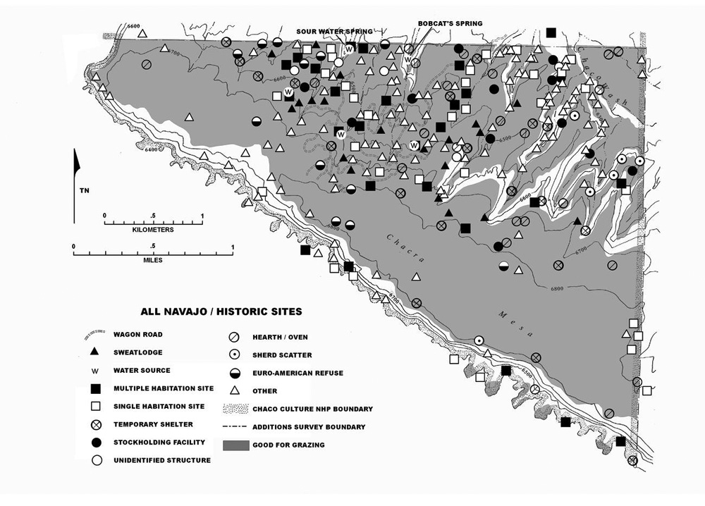 |
Figure 6.32. Chacra Mesa Navajo and historic sites in relation to areas considered good for grazing. |
¶ 214 In the Kin Bineola and Kin Klizhin survey areas, upland areas were combined with the good and fair agricultural lands to make 85.6 percent and 91.3 percent of those areas, respectively, good for grazing (Figures 6.33 and 6.34). In the South Addition, the rolling hills with sandy soil and the broad drainages southwest of the South Mesa scarp are included as good for grazing, along with the lowland area and a broad drainage on the east side of the survey area (Figure 6.35). This survey area has the smallest proportion of land with good grazing potential; 44.3 percent. Ranking the four survey areas for percentage of land with grazing potential producing the following order:
- 1) Kin Klizhin—91.3 percent
- 2) Kin Bineola—85.6 percent
- 3) Chacra Mesa—76.5 percent
- 4) South Addition—44.3 percent
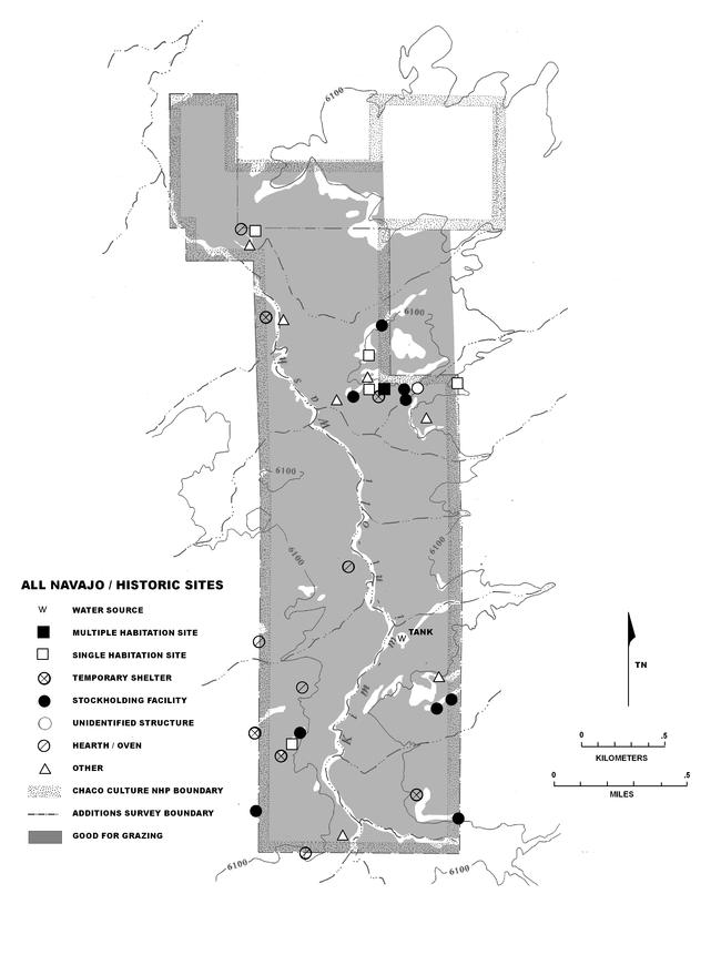 |
Figure 6.33. Kin Bineola Navajo and historic sites in relation to areas considered good for grazing. |
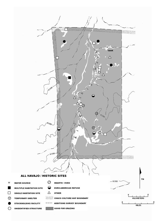 |
Figure 6.34. Kin Klizhin Navajo and historic sites in relation to areas considered good for grazing. |
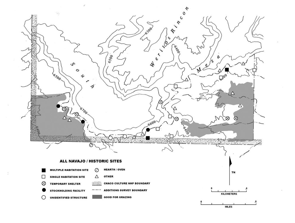 |
Figure 6.35. South Addition Navajo and historic sites in relation to areas considered good for grazing. |
¶ 215 In the area of the Chaco Additions, the Chaco River is the primary drainage, although it only flows intermittently at present. Secondary drainages include Kim-mi-ni-oli Wash, Kin Klizhin Wash, Fajada Wash, and a number of unnamed tributaries of the Chaco River which cut through the northeast flank of Chacra Mesa. Other sources of water include numerous bedrock tanks and seeps in the rough broken terrain of Chacra Mesa’s northeast flank. While many of these bedrock tanks are small and will hold only a domestic supply of water, others, such as that at 29SJ 2965 (a multiple habitation site), were observed to contain hundreds of gallons of water and would have been adequate for watering sizable herds of livestock.
¶ 216 In ranking the four survey areas for water availability, the above sources were considered, as well as the availability of snow during the winter on Chacra Mesa. Chacra Mesa contains innumerable water sources in the small seeps and bedrock tanks along its northeastern flank, as well as the Chaco Wash which passes through the northeastern corner of the survey area. Two springs on the northeastern flank of the mesa, within the survey area, also served as important sources of water for livestock, Tódik’óózhi (Sour Water) Spring,10Tódik’óózhi is variously translated as Sour Water or Salty Water (Fransted and Werner 1974) or Bitter Water Spring (Chapter 8, this volume). and Náshdóí Bitó (Bobcat’s Spring) (see Chapter 8).
¶ 217 Kin Klizhin and Kin Bineola each have only one major source of water, Kin Klizhin and Kim-mi-ni-oli Washes, respectively. These provide running water during particularly wet periods and stock ponds could be dug to catch runoff at other times of the year. The nearest sources of water to the South Addition survey area are most likely Fajada Wash to the south, and perhaps some bedrock tanks on top of South Mesa. Both sources are outside of the survey area itself.
¶ 218 Wells and stock tanks which are present in the survey areas were not included as water sources for this analysis, as all were constructed after the Navajo occupation of those areas, for the use of lessees (Fred York: personal communication 1986). As such, the survey areas were ranked as follows, for availability of water:
- 1) Chacra Mesa
- 2) Kin Bineola
- 3) Kin Klizhin
- 4) South Addition
¶ 219 In the above discussion, the four survey areas were ranked according to the percentage of land with agricultural potential, the percentage of land with grazing potential, and their availability of water. The ranking order is different for each of the three resources, but Kin Klizhin and Kin Bineola have the highest agricultural and grazing potential. Chacra Mesa has high grazing potential and water availability, while the South Addition ranks relatively low compared to the other areas in all three categories.
¶ 220 If the previously described changes in economic focus occurred in the survey areas, the habitation site density for each of the four survey areas should meet the following expectations: For the Pre-Bosque Redondo Period, 1700 to 1863, the survey area with the highest percentage of good/fair agricultural land should also have the highest habitation site density. The areas ranked second, third, and fourth for habitation site density should be ranked second, third and fourth for agricultural potential. For the period 1868 to 1930, when herding was the primary economic activity, the ranking of survey areas for habitation site density should be the same as that for grazing potential. For the period 1930 to 1980, when the need for proximity to all of these resources was mitigated by the widespread use of trucks and the replacement of agriculture and herding by wage labor, the locations of habitation sites will probably not be influenced by the distribution of these specific resources as during the earlier periods, although proximity to water and grazing land should still be an important factor. Therefore, it is expected that the ranking of areas for habitation site density during 1930 to 1980 will be similar to that for grazing potential and water availability.
¶ 221 Habitation site density by survey area by time period is presented in Table 6.20. Based on Table 6.20, the ranking of habitation site density for the period 1700 to 1863 is:
- 1) Chacra Mesa with 18 sites or 1.34 sites per km2
- 2) South Addition with 1 site or 0.48 sites per km2
- 3) Kin Bineola and Kin Klizhin with 0 sites or 0 sites per km2
|
Table 6.20. Site density (number of sites per km2). |
|||||
|---|---|---|---|---|---|
| Kin Bineola | Kin Klizhin | South Addition | Chacra Mesa | ||
| Area (km2) | 4.45 | 5.18 | 2.07 | 13.47 | |
| All Sites | 7.64 | 4.44 | 14.49 | 20.49 | |
| 1700-1863 | 0.22 | - | 0.48 | 3.56 | |
| 1868-1930 | 1.35 | 0.97 | 2.90 | 2.75 | |
| 1930-1980 | 0.67 | 1.54 | 6.76 | 4.38 | |
| Habitation Sites | 1.35 | 1.35 | 3.86 | 4.38 | |
| 1700-1863 | - | - | 0.48 | 1.34 | |
| 1868-1930 | 0.22 | 0.77 | - | 1.56 | |
| 1930-1980 | - | 0.19 | 0.48 | 0.74 | |
¶ 222 This does not correlate with the ranking of survey areas for agricultural potential. The Chacra Mesa Survey Area, although ranked first for habitation site density, ranks last for percentage of land good or fair for agriculture. The test, therefore, does not support the expectation of highest habitation site density in the two survey areas with the greatest percentage of agricultural land. This may indicate either that proximity to agricultural land was not the primary factor involved in settlement location between 1700 and 1863, or that the percentage of agricultural land in each survey area is not an accurate measure of available agricultural land. Areas with good agricultural potential may be located just outside of the survey area boundary. This appears to be the case with the Chacra Mesa survey area: substantial lands good for agriculture are located in the canyon bottom adjacent to Chaco Wash and in the side canyons just north of the survey area. If these areas are considered, Chacra Mesa has a significantly higher proportion of arable land.
¶ 223 For the period 1868 to 1930 the four survey areas are ranked for habitation site density as follows:
- 1) Chacra Mesa with 21 sites or 1.56 sites per km2
- 2) Kin Klizhin with 4 sites or 0.77 sites per km2
- 3) Kin Bineola with 1 site or 0.22 sites per km2
- 4) South Addition with 0 sites or 0 sites per km2
¶ 224 This ranking does not fit the expectation for this time period. Chacra Mesa, with the third lowest grazing potential has the highest settlement density. Kin Klizhin and Kin Bineola, with higher grazing potentials, have low settlement densities. Only the South Addition, with the lowest grazing potential, and no sites, meets the expectation.
¶ 225 For the period 1930 to 1980, the four survey areas are ranked for habitation site density as follows:
- 1) Chacra Mesa with 10 sites or 0.74 sites per km2
- 2) South Addition with 1 site or 0.48 sites per km2
- 3) Kin Klizhin with 1 site or 0.19 sites per km2
- 4) Kin Bineola with 0 sites or 0 sites per km2
¶ 226 With the exceptions of Chacra Mesa, where high settlement density and high water availability meet the expectation, and Kin Klizhin where low settlement density and low water availability also meet the expectation, the settlement density ranking for this period does not correlate with that for any of the three resources. The results are quite likely affected by the very low numbers of sites recorded for 1930 to 1980 in all areas except Chacra Mesa. The South Addition and Kin Klizhin have only one site each, and the Kin Bineola survey areas has no habitation sites. However, it is also likely that factors other than those recognized in this analysis were involved in settlement decisions for this late period of occupation.
¶ 227 In summary, the expectation that habitation site density for the three time periods would correlate with the relative abundance of key resources is for the most part is not supported by the ranking test. There are a few exceptions. During the 1868 to 1930 period an absence of sites in the South Addition correlates with low grazing potential, and during the 1930 to 1980 period, high site density on Chacra Mesa correlates with high water availability. At Kin Klizhin low site density matches the area’s low water availability. It is noteworthy that Chacra Mesa maintained the highest habitation site density regardless of time period, as well as the highest density of all site types for the 1700 to 1863 period and the second highest density for the two subsequent periods (Table 6.20). This suggests that, despite the higher percentages of land with agricultural and grazing potential at Kin Klizhin and Kin Bineola, Chacra Mesa’s substantial grazing potential (78%) in combination with the highest water availability of any area, were consistently important factors for settlement and land use throughout the Navajo and historic occupation of the Chaco area.
¶ 228 In order to further examine the relationship between land with agricultural potential, land with grazing potential, and water availability, the average distance from habitation sites to these three key resources was calculated for each time period. Because so few sites in the Kin Bineola, Kin Klizhin, and South Addition survey areas were datable to a specific period, only habitation sites from Chacra Mesa were included in this analysis. Changes through time in the distance from habitation sites to water, to land with agricultural potential, and to land with grazing potential are presented in Table 6.21.
|
Table 6.21. Distances (in meters) from habitation sites on Chacra Mesa to water and lands with agricultural and grazing potential. |
||||||
|---|---|---|---|---|---|---|
| Distance to Agricultural Land | Distance to Good Grazing Land | Distance to Water | ||||
| x̄ | sd | x̄ | sd | x̄ | sd | |
| 1700-1863 | 392 | 264 | 21 | 63 | 716 | 386 |
| 1868-1930 | 409 | 257 | 28 | 85 | 735 | 413 |
| 1930-1980 | 363 | 203 | 6 | 15 | 785 | 462 |
| ANOVA | F(2,44)=0.10, P=0.905 | F(2,46)=0.328, P=0.722 | F(2,46)=0.086, P=0.918 | |||
¶ 229 In measuring distance to water from habitation sites on Chacra Mesa, four sources were considered substantial enough for purposes of watering livestock, and only these four were included in the calculations. They include Chaco Wash, Fajada Wash to the south of the survey area, and the two springs: Sour Water and Bobcat’s Springs (see Figure 6.32).
¶ 230 It was expected that the distance from habitation sites to land with agricultural potential would be lowest during 1700 to 1863, and highest between 1930 and 1980. Second, distance from habitation sites to good grazing land was expected to be lowest between 1868 and 1930. Third, distance to water was expected to be lowest between 1700 and 1863 and highest after 1930. One Way Analysis of Variance tests (Siegel 1956) revealed that the distances from habitation sites to each of these three resources did not change significantly through time (Table 6.21). With the small survey areas involved in the present study, one reason that these distances did not change through time may be the plateau effect, where below a certain point the distance to resources is relatively insignificant (Morrill 1974).
¶ 231 The results of both the resource abundance and distance tests suggest that no single factor was all important in site location decisions. Other factors which are probably important to winter habitation site locations include protection from wind and weather, and proximity to fuel wood (Brugge 1986:148). Prior to 1868 Navajos had to consider locating defensively against attack from their enemies (Brugge 1986:152). By the end of the nineteenth century and into the early twentieth century, homestead and grazing rights of other Navajo families and Anglo herders limited where settlements and camps could be placed.
¶ 232 A third factor in settlement location may have been the “rico phenomenon.” After 1882 a wealthy class of Navajos developed and was able to acquire large herds and dominate the range land, thus limiting the good range land available to smaller, poorer Navajo families (cf. Boyer 1982). The effect of this economic stratification of Navajo families was, however, probably minor when compared to the impact of the intrusion of Anglo ranchers (Ed Sargent, in particular) and Spanish-American partidarios (cf. Kelley 1982a).
¶ 233 Clearly, the selection of locations for settlement was not simply a matter of locating as close as possible to a single resource. However, most studies which have been done on Navajo settlement for the Post-Bosque Redondo period indicate that grazing land and/or water were the prime considerations (cf. Bailey and Bailey 1982:37; Boyer 1982:109; Gilpin 1983:973; Kelley 1982a:342). The spatial distribution of the Navajo sites by time period for each of the four survey areas, discussed below, provides further insight into the factors important to settlement in the Chaco Additions.
Kin Bineola and Kin Klizhin
¶ 234 These two survey areas are discussed together because of their great similarities. For both areas, site density is relatively low when compared with the South Addition and Chacra Mesa (Table 6.20). Only one site, a rock art site in the Kin Bineola survey area, was dated to the early period, 1700 to 1863 (Figure 6.36). By the next period, 1868 to 1930, site density had increased, with both areas exhibiting their greatest habitation site densities, although only one habitation is found in the Kin Bineola area and four in the Kin Klizhin survey area (Figures 6.37 and 6.38). The period 1930 to 1980 sees a decline in habitation site density, although Kin Klizhin has an increase in overall site density caused by the occurrence of a habitation, three stockholding sites, two rock art sites, a corn field, and a dam (Figures 6.39 and 6.40).
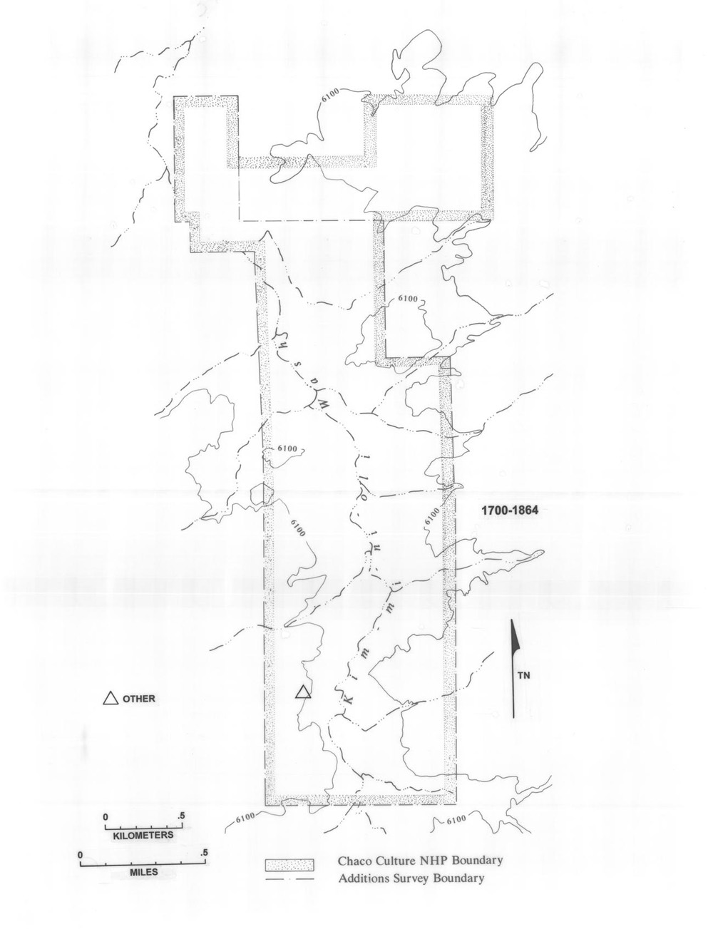 |
Figure 6.36. Sites dating from 1700 to 1863 in the Kin Bineola survey area. |
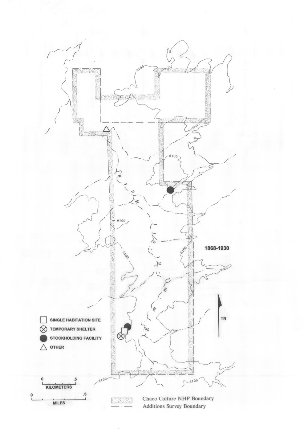 |
Figure 6.37. Sites dating from 1868 to 1930 in the Kin Bineola survey area. |
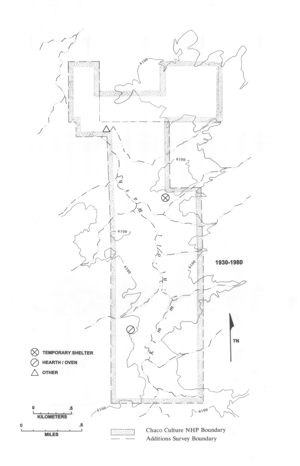 |
Figure 6.38. Sites dating from 1868 to 1930 in the Kin Klizhin survey area. |
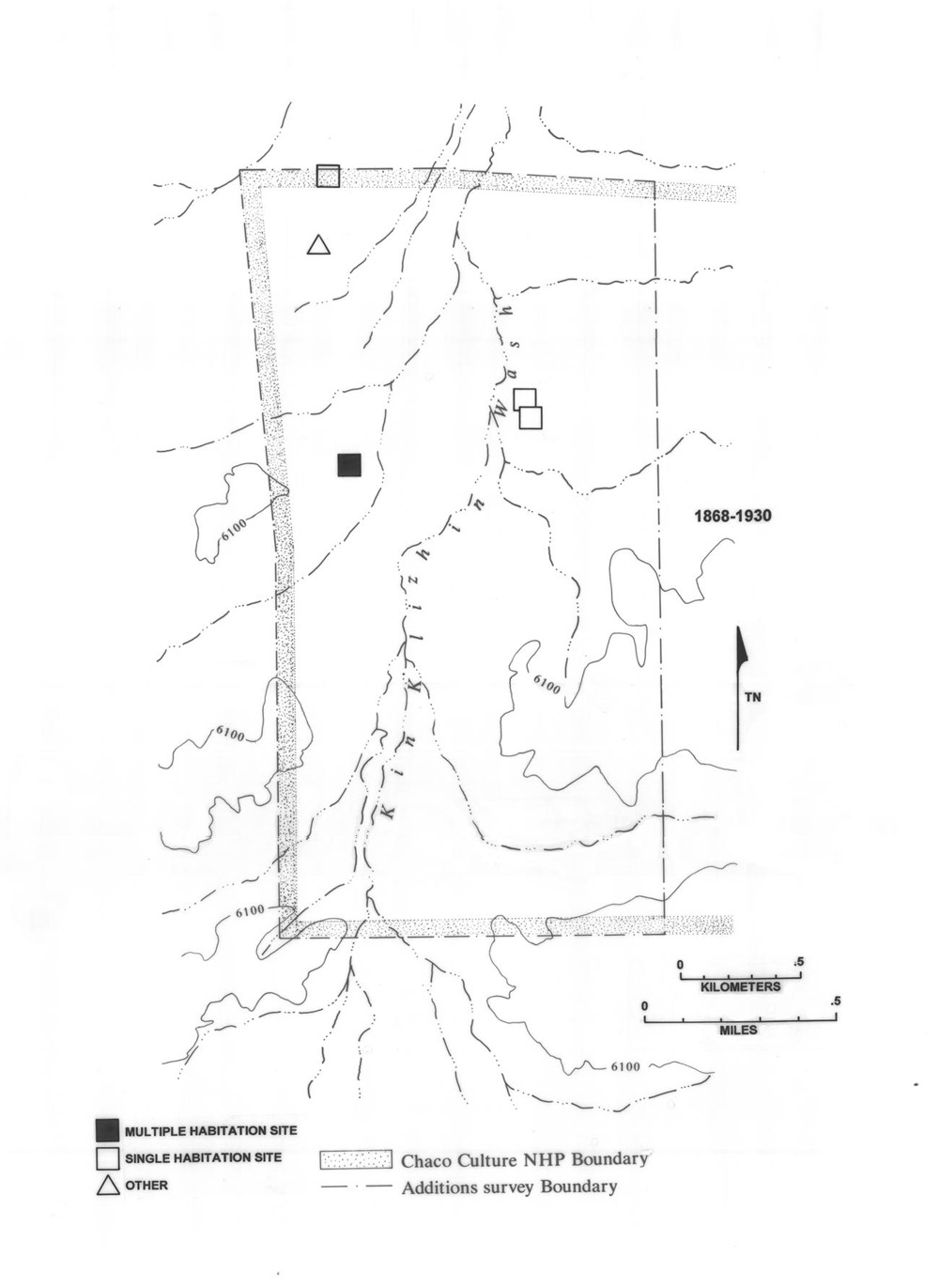 |
Figure 6.39. Sites dating from 1930 to 1980 in the Kin Bineola survey area. |
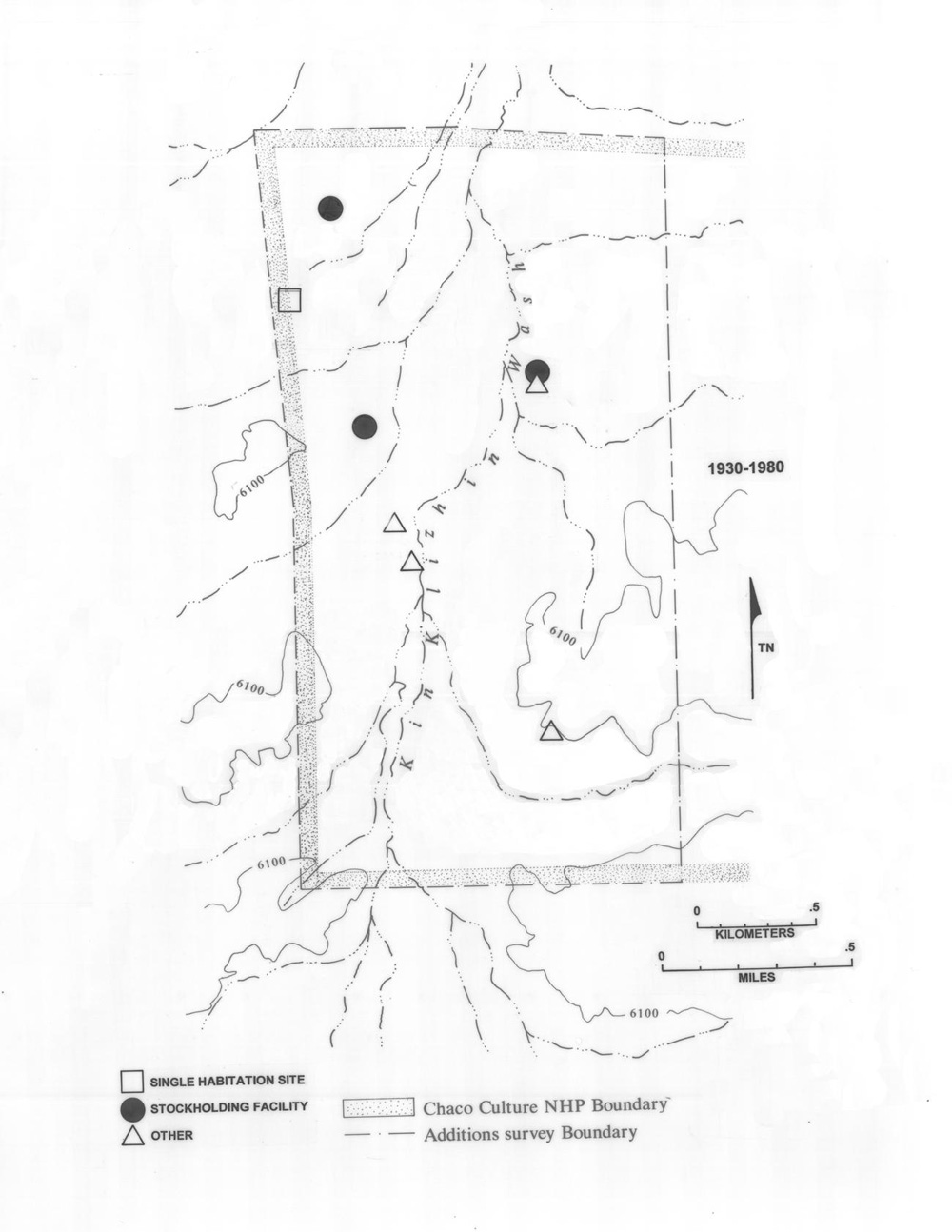 |
Figure 6.40. Sites dating from 1930 to 1980 in the Kin Klizhin survey area. |
¶ 235 For all periods, sites tend to be located against sandstone outcrops (Figures 6.33 and 6.34), where protection from the elements could be attained, and where abundant materials for the construction of hogans and corrals were available. Rincons in the sandstone also afforded convenient natural enclosures used in the construction of corrals. At Kin Bineola, five out of six habitation sites and eight out of 20 temporary campsites (including temporary shelters, stockholding facilities, unidentified structures and hearths/ovens) are located in the northern half of the survey area and almost all were established near rock outcrops and cliff faces. At Kin Klizhin, the same is true, with six out of seven habitation sites and three out of ten temporary camps in the northern portion of the survey area; again most have sandstone or badland outcrop backdrops. Many temporary campsites, in both survey areas, are located in the southern portions, and although some camps are not associated with sandstone or badland outcrops, the majority are. Many of these temporary campsites were most likely sheep camps. Given the pervasiveness of grazing land in both areas, it was probably a minor consideration in the placement of habitations and temporary campsites on the landscape.
South Addition
¶ 236 As in the Kin Bineola and Kin Klizhin survey areas, South Addition habitation sites, throughout time, tend to be located against sandstone outcrops, but not necessarily near good grazing or agricultural land. Habitations as well as temporary campsites are located primarily at the base of the steep southern scarp of South Mesa (Figure 6.35). The South Addition survey area exhibits increasing use through time, if all site types are included (Table 6.20). Overall site density in this area even surpasses that for Chacra Mesa during the 1868 to 1930 and 1930 to 1980 time periods, largely due to the presence of inscriptions dating to both periods and temporary camp sites (probably sheep camps) occupied after 1930. Only one site, a multiple habitation, was dated to the early period in the South Addition (Figure 6.41).
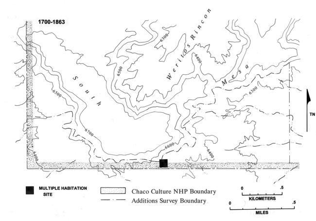 |
Figure 6.41. Sites dating from 1700 to 1863 in the South Addition survey area. |
¶ 237 Six campsites dating to 1868 to 1930, all have inscriptions made by Spanish-American herders (Figure 6.42). Occupation during this period was therefore predominantly, if not exclusively, by Spanish-American herders. All inscriptions specifying month and year indicate use during the winter months. After 1930 sites include a single habitation site, five temporary shelters, one stockholding facility, six rock art panels, and a coal mine (Figure 6.43). Inscriptions at many of these sites indicate use of the area continued to be dominated by Spanish-American herders, again during the winter months. Temporary shelters, stockholding facilities, and rock art sites in the South Addition are probably all the remains of sheep camps.
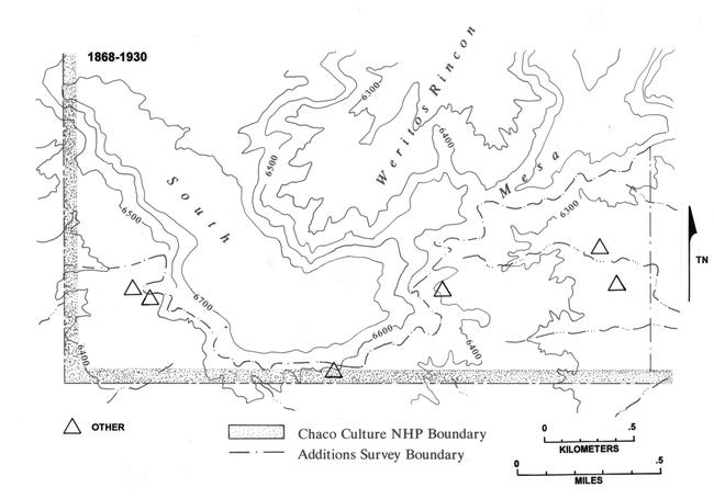 |
Figure 6.42. Sites dating from 1868 to 1930 in the South Addition survey area. |
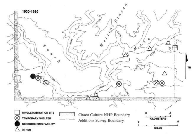 |
Figure 6.43. Sites dating from 1930 to 1980 in the South Addition survey area. |
¶ 238 Unfortunately, most of the Navajo hogan sites in this survey area remain undated, so the Navajo use of the area for each time period is probably underestimated. With a habitation site density very near that on Chacra Mesa, the importance of this area for Navajo occupation should not be overlooked.
¶ 239 With the South Addition ranked lowest of the four areas in terms of availability of water and grazing potential, one must wonder why the density of sheep camps is so high. Once again, the small size of the survey area is probably a factor. Although resources in the South Addition itself appear to be relatively poor for herding, to the west and south of the survey area are quite expansive areas of grazing land. Also, immediately east of the survey area, the floor of Chaco Wash provides good grazing land and the wash itself provides frequently available water. These resources are within easy herding distance of the camps in the South Addition, which may have been selected primarily because of the natural shelter afforded by the outcrops and talus boulders at the base of South Mesa.
Chacra Mesa
¶ 240 The Chacra Mesa survey area not only has the largest variety of water sources of the four survey areas, it has the greatest habitation and overall site density as well. And, over three-quarters of the survey area has good potential for grazing. This suggests that grazing potential and water are indeed important resources to Navajos in the Chaco area. Subtle changes through time in the settlement patterns of the Chacra Mesa survey area offer some indication of the changing importance of resources from one period to the next.
1700 to 1863
¶ 241 The presence of eight multiple habitations and ten single habitation sites (with a total of 38 habitation structures, or 2.1 habitations per site) provides for a habitation site density of 1.34 sites per km2, nearly as high a density as for the 1868 to 1930 period and a substantially higher density than for any other period of occupation in any of the other three survey areas (Table 6.20). In addition, some of the eight hearth sites and seven sherd scatters recorded for this period were probably habitation sites with forked-stick hogans, of which no traces now remain due to removal or deterioration.
¶ 242 Heavy use of Chacra Mesa during this period has been well-documented by Brugge (1986) and Vivian (1960). As was found in those surveys, sites are concentrated along the northeastern flank of the mesa (89 percent) along drainages which flow into Chaco Wash (Figure 6.44). The mesa top is virtually unused during this period, with only one habitation site and three temporary camps (one temporary shelter and two sherd scatters) on the mesa top, all at the edge of the steep southern or western scarp. Eighty-three percent of the habitations are in protected areas, against sandstone cliffs, ledges, or large boulders where both human occupants and livestock would have been sheltered from the wind and snow.
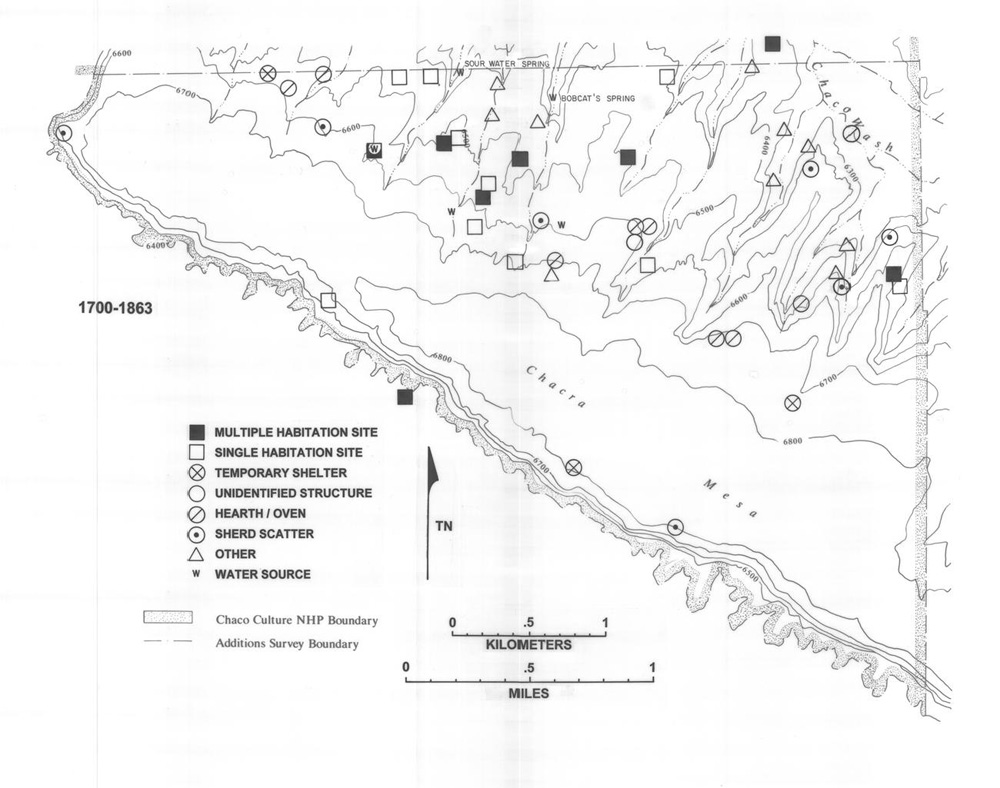 |
Figure 6.44. Sites dating from 1700 to 1863 in the Chacra Mesa survey area. |
¶ 243 Twelve of the 18 habitation sites from this period (67 percent) are located in the north central part of the survey area near the drainages which contain the two springs, Bobcat’s Spring and Sour Water Spring (Figure 6.44). A Nearest Neighbor Analysis (Clark and Evans 1954) produced a statistic, “R,” of 0.468, indicating a tendency for these sites to cluster (Table 6.22). Although the measured clustering is between sites, it seems likely that this aggregation of settlement reflects use of these two springs.
|
Table 6.22. Nearest neighbor analysis for habitation sites on Chacra Mesa. |
||||
|---|---|---|---|---|
| No. of Habitation Sitesa | Average Distance (meters) | Expected Distance (meters) | Rb | |
| 1700-1863 | 12 | 260 | 555.56 | .468 |
| 1868-1930 | 16 | 233.25 | 476.19 | .490 |
| 1930-1980 | 8 | 391.5 | 714.28 | .548 |
| The total area of the
Chacra Mesa addition is 13.456 km2
or 5.20mi2. aEdge effect was corrected by excluding any habitation site located nearer to the boundary of the survey area than it was to another habitation site. bR may range from 0 to 2.1491. A value of 1.0 is the expected or random distribution, where every point is equidistant from every other point. Under conditions of maximum aggregation or clustering, R=0, since all points occupy the same locus. Under conditions of maximum spacing between points, R=2.1491, and the points form an even, hexagonal pattern. As emphasized by Clark and Evans (1954: 447), “in any given distribution, the mean observed distance to nearest neighbor is R times as great as would be expected in a random distribution of the same density. Thus, an R value of 0.5 would indicate that nearest neighbors are, on the average half as far apart as expected under conditions of randomness.” |
||||
¶ 244 One aspect of the distribution of habitation sites from this period that is distinctive when compared with the two later periods, is the location of three sites on the four steep, narrow finger-ridges in the extreme northeastern corner of the survey area (Figure 6.44). These sites are accompanied by five Navajo rock art sites, three sherd scatters, two hearth sites, and a possible burial. The three habitation sites, 29SJ 1659, 29SJ 2606, and 29SJ 2631, appear to be located defensively. They fit well with Brugge’s (1986:142) and Vivian’s (1960:218) description of eighteenth century Navajo site location: in areas close to agricultural lands and in defensive situations. Most habitation sites, however, are located further to the west, in the north-central part of the survey area, where the slope is less difficult to climb and access to the Chaco Wash drainage below would have been easier. The mesa slope throughout the survey area is relatively close to good agricultural land as well as grazing lands.
¶ 245 Temporary camps from this time period include four temporary shelters, one unidentified structure, eight hearth/baking pit sites, and seven sherd scatters. The absence of animal enclosures at these sites may indicate that sheep were bedded in the open, or it may be a result of poor preservation. Regardless, it seems likely that temporary campsites were generally hunting or gathering camps rather than sheep camps. This fits with historical evidence that herding was relatively unimportant prior to the return from Fort Sumner and that the hunting and gathering of natural resources contributed substantially to a subsistence economy based primarily on agriculture. Only one site dating to this period contained the remains of a corral. Although corrals of brush would likely have deteriorated since this time, the general paucity of animal enclosures is taken as evidence that stockraising was practiced but relatively unimportant.
1868 to 1930
¶ 246 During the Post-Bosque Redondo Period there is a drop in the total number of sites in the Chacra Mesa survey area, but the number of habitation sites increases (n=21), and thus, habitation site density changes from 1.34 sites per km2 to 1.56. At the 21 habitation sites there are a total of 30 habitation structures or 1.4 structures per site. Sites continue to be concentrated in the central portion of the northeastern flank of the mesa, especially along the drainage above Sour Water Spring (Figure 6.45). A Nearest Neighbor statistic “R” of 0.490 (Table 6.22) indicates that the distribution of these sites tends toward clustering, and that they are slightly less clustered than habitations from the earlier period.
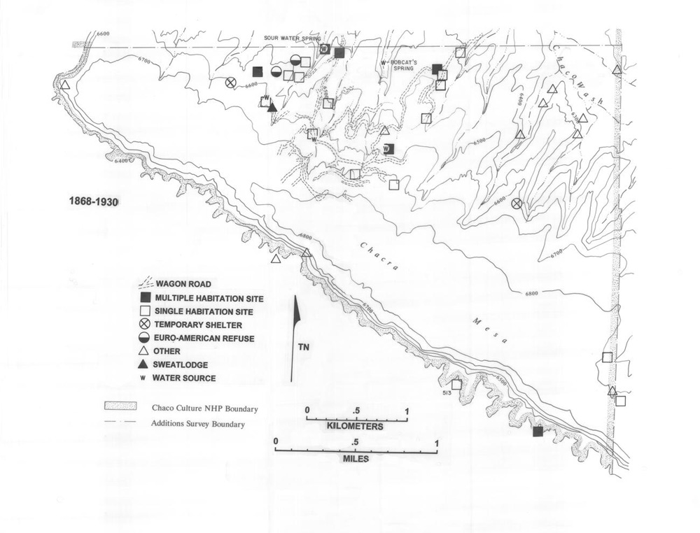 |
Figure 6.45. Sites dating from 1868 to 1930 in the Chacra Mesa survey area. |
¶ 247 The broad ridge to the east of Bobcat’s Spring now contains five habitation sites. A wagon road passes by all five sites. Based on the occupation dates of these sites (Appendix 6.1, Table 1) the road was probably constructed during the 1920s, indicating that this is one of the earliest segments of road constructed in the survey area. A rather poorly defined segment of the wagon road system that may also date to the 1920s climbs the ridge just east of Sour Water Spring before heading southwest, and crossing a drainage below several single habitation sites which it appears to have served.
¶ 248 As in the previous period, the mesa top appears to be virtually unutilized. Two single habitations and a rock art site located at the head of a drainage in the far southeastern corner of the survey area are just at the edge of the mesa top. At the opposite end of the survey area is a stone wall on a point on the western edge of Chacra Mesa. No sites are located on the expansive open mesa top. Eighty-six percent of the habitation sites are located on the northeastern slope of the mesa. Eighty-six percent of the habitations are also in protected locales, against ledges or outcrops of sandstone.
¶ 249 Temporary campsites dated to this period include only two temporary shelters and two Euro-American trash scatters. One of these contains a corral and, therefore, was a sheep camp. The others are of unknown function. Eight of the 21 habitation sites (38 percent) contain corrals, compared with only 5 percent of the Pre-Bosque Redondo habitation sites. These changes suggest that the number of families with livestock increased, although the possible disappearance of evidence for corrals at earlier sites may be a factor in this difference.
¶ 250 The northeastern corner of the survey area, where several Pre-Bosque Redondo habitation sites were located, is uninhabited during this period. Sites in this area for the period 1868 to 1930 are limited to rock art panels and include both Navajo pictorial designs and Spanish-American inscriptions.
¶ 251 The location of earlier sites in defensible locations in the northeastern portion of the survey area suggests that defense was an important consideration for pre-1864 populations. The fact that no habitations are located in the northeastern portion of the survey area after 1868 probably reflects the cessation of warfare and supports the hypothesized change to an economy more dependent on stockraising and less on agriculture.
¶ 252 The narrow, finger ridges in the northeastern corner are bounded by steep sandstone cliffs. These cliffs made the area more defensible and probably more appealing to Pre-Bosque Redondo populations. They did, however, impede the movement of livestock. For families involved in stock raising, movement between habitations, camps, and water sources would have been much easier in the western portion of the survey area, where the slope is more even. As herding became the primary economic endeavor after 1868, families located habitations and temporary campsites where travel between grazing areas, homesites, and water sources was easiest. With the use of wagons during this period, the construction of wagon roads was more easily accomplished in the western portion of the northern mesa slope where habitation sites were located, improving access even more. As such, it appears that for the period 1868 to 1930 considerations for settlement included ease of movement, as well as proximity to water and grazing land.
1930 to 1980
¶ 253 During the Modern Period, habitation site density drops on Chacra Mesa, also for the first time the number of multiple habitation sites exceeds that of single habitations. Altogether there are seven multiple and three single habitations, with a total of 29 habitation structures and 2.9 habitation structures per site (Figure 6.46, Table 6.1). Families using Chacra Mesa, therefore, appear to have become more consolidated into extended family communities. The overall site density also increases substantially during this period (Table 6.20). This is largely a result of greater numbers of temporary campsites and rock art sites, indicating that use of the mesa continued to be important to herding.
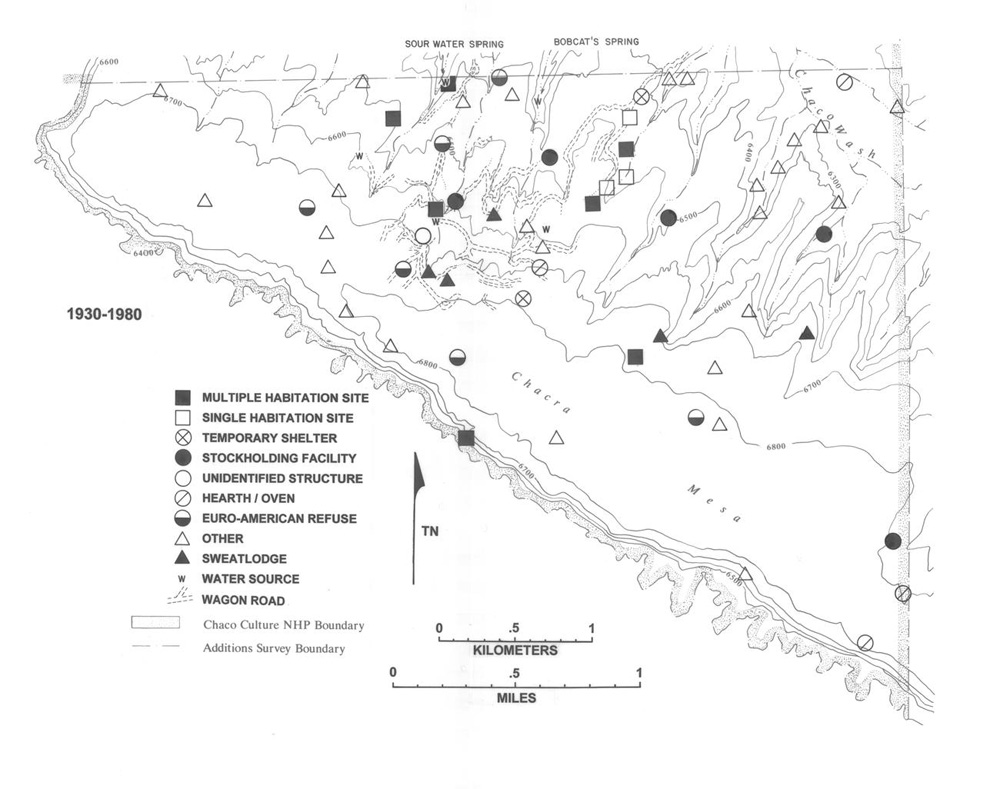 |
Figure 6.46. Sites dating from 1930 to 1980 in the Chacra Mesa survey area. |
¶ 254 The northeastern flank of the mesa still contains most of the habitation sites, particularly the ridge top east of Bobcat’s Spring (Figure 6.46). A Nearest Neighbor Statistic, “R,” of 0.548 (Table 6.22) and the distribution of sites in Figure 6.46 indicate that habitation sites from this period also tend to cluster in this section of the survey area. The degree of clustering, however, is slightly less than for the Post-Bosque Redondo Period. Ninety percent of the habitations dating to 1930 to 1980 are in protected areas, sheltered from the wind and snow.
¶ 255 Once again, the northeastern portion of the survey area contains no habitation sites, suggesting that ease of movement between grazing areas and water sources continued to be a major consideration for settlement location. Wagon roads criss-cross the slopes above Bobcat’s and Sour Water springs but pass through few habitation sites. Most of the habitation sites dating to this period are, however, close to a road segment. Many other, undated, Navajo habitations located along these roads are possibly from this time period. A number of temporary camps and other special use sites are also located along the roadways. These include two temporary shelters, two stockholding sites, a hearth, three sweat lodges, two Euro-American refuse scatters, and a rock art panel.
¶ 256 Six of the ten habitation sites from this period (60 percent) contain corrals or lamb pens. This is a substantial increase from the 38 percent of habitation sites containing animal enclosures in the previous period. One of the three temporary shelter sites, as well as five stockholding sites also contain corrals, indicating that most families in this area still owned livestock, and perhaps, that the number of families with livestock increased since 1930.
¶ 257 For the first time significant numbers of sites are located on the mesa top. These include four wood cutting areas, four Euro-American refuse scatters, two rock art sites, two hearth sites, a corral, a stone cairn site, and a windmill. With the use of wagons and possibly trucks, fuel and construction wood could be collected from the mesa top and transported to habitation sites on the slope below. Some of these wood cutting areas, however, may have been herder’s tent camps (cf. Kelley 1982a:315). Although the activities which occurred at some of the other mesa top sites are unknown, many probably were related to stockraising. At the very least, the corral and windmill (29Mc 472) are indications of herding on the mesa top after 1930. The windmill was installed in the 1960s by a lessee from outside of the Chaco Region (York: field notes).
¶ 258 Although no habitation sites are found in the northeastern portion of the survey area, the Chaco Wash and the lower side drainages flowing into it contain several rock art sites, a stone feature, a stockholding site, and a hearth site (Figure 6.46). Dated inscriptions reveal that Spanish-American herders used this area during the 1930s and 1940s. Navajo pictorials are also present in many of these rock art panels, indicating that Navajo herders also continued to use the area.
Early Navajo Demography
¶ 259 When available, ethnographic information and historic records can provide a sound basis for estimating the population of an area, but in the Chaco Canyon area these are generally available only for the periods after the return from Fort Sumner, post-1868. Because of this, a discussion of demography for the post-Fort Sumner population of the Chaco Additions is included in Chapter 8. In the absence of living informants and historic documentation, Pre-Bosque Redondo population estimates are at best, educated guesses, based generally on the number of habitation structures dated to a given period. Recent archeological approaches for estimating population size of Navajo groups have taken two distinct perspectives. These are exemplified by Gilpin’s (1983) population estimates for the Navajo Indian Irrigation Project (NIIP) area, and Brugge’s (1986) population estimates for the Doll House Site on Chacra Mesa.
¶ 260 Gilpin (1983) estimates potential Navajo population size in a portion of the NIIP area on Gallegos Mesa, northwest of Chaco Canyon, based on carrying capacity of the project area. Following Jochim’s (1976) model he estimates that the number of people that can be supported by an area is equal to the number of kilocalories in the flora and fauna of the area divided by 730,000 (the number of kilocalories required per person per year). Group size is calculated with the formula wnad/m, where w is weight, n is non-food yield, a is aggregation, d is density, and m is mobility. To determine Navajo population size in the early twentieth century, the number of sheep units assigned to the families of the project area (6,006) was divided by the replacement rate of the herds (20 percent). With an edible weight of 30 to 55 pounds per animal, and an estimated 1,360 calories per pound, 20 percent of 6,006 sheep was multiplied by 30 or 55 pounds, multiplied again by 1,360 and divided by 730,000. Accordingly, the number of people that this NIIP survey area could have supported was estimated to be between 67.18 and 123.16 (Gilpin 1983:973). Aside from the assumptions inherent in the above formula, Gilpin’s model assumes that the population was supported by subsistence herding alone, a factor that may cause the estimate to be low. This is counteracted by the assumption that the local population was at the maximum the environment allowed. Gilpin (1983:973) does, in fact, suggest that prior to 1907 the project area probably supported fewer than 30 people.
¶ 261 Brugge (1986) takes a different approach to estimating the population size in the immediate area of the Doll House Site, a Navajo multiple habitation site located on a bluff overlooking Chaco Wash, just outside of the Chacra Mesa survey area, northeast of 29SJ 1620 and Tódik’óózhi or “Sour Water” Spring. Brugge assumes that each of the four house clusters recorded at the site represents a separate temporal component. The population of each component is then estimated based on the number of hogans and/or pueblitos associated with it. He generally figures a household size of four persons per hogan; except for larger clusters of contemporaneous hogans, where one of the hogans is assumed to have been occupied by an elderly couple without children. Thus, he arrives at the following population estimates (1986:137):
| Early eighteenth century | 4 |
| Mid-eighteenth century | 14 |
| Late eighteenth century | 20 |
| Early nineteenth century (a) | 14 |
| Early nineteenth century (b) | 8 |
| Late nineteenth century, early twentieth century | 6 |
| Mid-twentieth century | 8 |
¶ 262 Brugge’s method also relies on a number of unverifiable assumptions: that the hogans/pueblito rooms of each cluster were occupied contemporaneously, that each hogan or room housed a single nuclear family, and that clusters of these structures housed extended family groups. His average estimated household size, four individuals per nuclear family, is slightly lower than that suggested elsewhere, as will be discussed below.
¶ 263 As shown above, the 220-year long occupation of the Doll House Site vicinity was divided into seven components, providing for an average length of occupation of more than 30 years per hogan or room. While this may have been the case at the Doll House Site, where location obviously attracted inhabitants for a long period of time, I believe that in general, Navajo hogans were inhabited for much shorter time intervals. As such, Brugge’s population estimates for the Doll House Site may be high.
¶ 264 Klara Kelley (1982a) estimates the early twentieth century population of the Chacra Mesa area at 37 people, based on ethnographic information and historic records. She observes that there were three families who were granted allotments in the Chacra area, and estimates that together they maintained seven households with a total of 37 people (Kelley 1982a:196). This is an average of 5.28 individuals per household. This figure is very close to the size (5.16 persons) of the average nuclear family household in the Navajo Mountain Community (Shepardson and Hammond 1970:Appendix B). In the latter study, a range of from one to 18 people per household was observed, with each nuclear family occupying a separate hogan (Shepardson and Hammond 1970:44).
¶ 265 In order to estimate the Pre-Bosque Redondo population in the four Chaco Addition survey areas, a method similar to that used by Brugge (1986) and Kelley (1982a) is employed.
¶ 266 One great difficulty in estimating population size for the Pre-Bosque Redondo Navajo is that many forked-stick hogans of the period may not have been identified as habitations. Some of the hearth and sherd scatter sites dated to this period may, in fact, be habitation sites. Additionally, with only 43 percent of the sites dated to a particular temporal period, it must be assumed that a number of the undated sites are from this Pre-Bosque Redondo Period. These problems may lead to an underestimation of population size.
¶ 267 As with all previous population estimates of historic Navajo groups, it was necessary to make a large number of unverifiable assumptions. To begin with, it is assumed that each recorded hogan is a winter habitation structure housing a single nuclear family. While many hogans were probably occupied during other seasons as well, it seems likely that few were built exclusively for warm season use. Second, based on ethnographic information it is assumed that although Navajo extended families often reside together, each nuclear family occupies a separate hogan (Kluckhohn and Leighton 1962:100-104; Shepardson and Hammond 1970:44).
¶ 268 In her study of the Black Hat Navajo, Kelley (1982b) found that hogans of 3.5 meters diameter or less tended to house one or two hired herders or young male relatives of big stock owners. Nuclear families almost always lived in hogans larger than 3.5 m diameter (Kelley 1982b:52). Although this has been taken into consideration in the present analysis, the average floor area for hogans in the Chaco Additions is substantially smaller than in the Black Hat area. Fully 90 percent of the hogans from the Pre-Bosque Redondo Period are smaller than 3.5 m in diameter (9.6 m2 floor area) and it is doubtful that these housed single males. Although this may result in artificially large population estimates, it is assumed that all hogans from 1700 to 1863 housed nuclear family households.
¶ 269 Although Kelley (1982a) and Shepardson and Hammond (1970) estimate average household size at slightly more than five persons, the average size of hogans in the Chaco Additions is small during 1700 to 1863 (7.5 m2 for multiple habitation sites and 5.3 m2 for single habitation sites). This may indicate that household size was smaller than in the ethnographic examples. In addition, the well documented increase in hogan floor area through time suggests a small household size. As such, a household size of four individuals is considered more appropriate for the 1700 to 1863 period.
¶ 270 No habitation sites dating to the 1700 to 1863 period were recorded in either the Kin Bineola or Kin Klizhin survey areas. One rock art site in the Kin Bineola survey area contained incised Ye’i figures and zoomorphs, revealing that Navajos used that area on at least a temporary basis, if only as a corridor to agricultural and grazing lands on the Chaco Wash.
¶ 271 One habitation site with two hogans was dated to this period in the South Addition survey area. This is the only site in the survey area dating to the 1700 to 1863 period. Assuming the two hogans were occupied contemporaneously, this site may have housed about eight people; if occupied separately, the population would have been half this number. The hogans were both under 3.5 m in diameter and may, therefore, have been for temporary use by herders rather than seasonal family dwellings.
¶ 272 Eighteen habitation sites dating to this period (1700 to 1863) were recorded in the Chacra Mesa survey area. Collectively, they contain 38 hogans. Three of these hogans are two-room structures, the individual rooms of which are no smaller in floor area than many of the other hogans from this period. As such each room of a two-room hogan is counted as a separate nuclear family household, raising the total to 41 hogans or rooms.
¶ 273 The majority of the sites placed in the 1700 to 1850 period were dated on the basis of ceramics. In estimating population size, it was desirable to separate the Pre-Bosque Redondo Period into smaller temporal components in order to examine the data for differences in population between the early, agricultural period (1700 to 1800) and the period of raiding and warfare (1800 to 1863) when it has been suggested the population of the Chaco area was severely reduced (Brugge 1986:144). Only four sites of the 18 habitation sites were dated precisely enough for placement into one of these two sub-periods. Two sites, 29SJ 2606 and 29SJ 2644, were dated to the early period, 1700 to 1800. Site 29SJ 2606 contained 12 habitation structures: 11 hogans and one house. Ceramics dating from 1700 to 1850 indicated that most of these structures were occupied during the Pre-Bosque Redondo Period. No Euro-American artifacts were recorded at the site, but because Anglo-style houses were not introduced to the Navajo until the 1870s (Bailey and Bailey 1982:131), it is assumed that the house at 29SJ 2606 dates to after that time. Three hogans at 29SJ 2606 produced six tree-ring dates of between 1771 and 1793. The clustering of these dates indicates that they are fairly close to the actual construction dates of those hogans. Although based largely on conjecture, it is assumed here that all 11 of the hogans at this site were occupied prior to 1800. Site 29SJ 2644 contained only one hogan.
¶ 274 Two sites dated between 1800 and 1863. Site 29SJ 2932 produced a cluster of four tree-ring dates (1805 to 1812) and contains a single hogan. Although these are all non-cutting dates (vv or +vv), the clustering does indicate a possible early nineteenth century date. Site 29SJ 2945 was dated ceramically at 1800 to 1850. It contains two hogans, one of which has two rooms.
¶ 275 In summary, 12 of the 16 hogans/rooms which could be dated to a specific sub-period (75 percent) date to 1700 to 1800. Four of them (25 percent) date to 1800 to 1863. As a crude estimation of the number of hogans occupied in each sub-period, the total (n=41) was multiplied by the above ratios: 75 percent, or 31 hogans were occupied during the 1700 to 1800 period; 25 percent, or 10 were occupied during the 1800 to 1863 period. These are considered the minimum number of hogans occupied during each of the two periods. To account for habitation sites where no surface indications of hogans remain, and provide a maximum number of hogans for each period, the seven sherd scatters and eight hearth sites from the Pre-Bosque Redondo Period are added in, with an estimated 1.5 hogans at each. This produces 22.5 additional hogans (rounded to 22), 16 (75 percent) from 1700 to 1800 and six (25 percent) from 1800 to 1863. As a result, the maximum number of hogans for the 1700 to 1800 interval is 47. The maximum number for the later portion of the period (1800 to 1863) is 16.
¶ 276 It is also difficult to estimate the average length of stay for each hogan. Brugge’s (1986) 30 year occupations seem too long for most Navajo hogans, and ethnographic information indicates that an average of 10 years at each hogan is generous (York: field notes). For the 100-year period 1700 to 1800, it was assumed that each hogan was occupied for 10 years, and the total number of hogans was divided by 10. For the 63-year 1800 to 1863 interval, an assumed 10 year occupation span produces a denominator of 6.3.
¶ 277 For the period prior to 1800, a minimum estimation of population is calculated by dividing the number of hogans (31) by 10, then multiplying by four people per hogan: 12.4 people. Maximum population would be 47 divided by 10, times four, or 18.8 people. Based on these calculations, prior to 1800 the population of the Chacra Mesa survey area averaged 12 to 19 individuals, living in 3 to 5 nuclear households.
¶ 278 From 1800 to 1863 between 10 and 16 hogans were occupied. Dividing by 6.3, then multiplying by four people per hogan, the population range is six to ten individuals, or one to three households.
¶ 279 These calculations do indicate a slight drop in population on Chacra Mesa after 1800, although neither period shows evidence of a population larger than 19 people at any one time. A similar reduction in the number of hogans occupied during the period of raiding and warfare was observed in other portions of Chaco Canyon and on the portions of Chacra Mesa to the east of our survey area (Brugge 1986:144). Within these latter areas over 60 hogan sites were found dating to the eighteenth century; while only 10 were from the period 1800 to 1863. Brugge (1982:101) notes that tree-ring dates for the Chacra Mesa area show a dramatic decline in hogan construction following the smallpox epidemic of 1780 to 1781 and a high proportion of late eighteenth century hogans with indications of abandonment due to death. Populations after this time remained small. Powers (1985) attributes this in part to a deterioration of climatic conditions resulting in a long period of accelerating warfare and raiding in the Chaco area. Unfortunately, dating of the sites in the Chaco Addition survey areas is generally not precise enough to provide a clear indication of changes in population after the late 1700s. The population figures arrived at for the survey areas remain conjectural.
Conclusions
¶ 280 Many of the results of this study support previous assertions concerning historic Navajo economy and land use. Data from the project area confirm Brugge’s (1986:83) statement that the earliest Navajo occupation in the region is on the northeastern flank of Chacra Mesa, near the mouths of the small side canyons which flow into Chaco Wash. The earliest dates for sites in the survey areas were obtained from ceramics recorded at two small campsites (hearth sites) on the northeastern slope of Chacra Mesa. Both possibly date to 1600 to 1680; however, the earliest reliable tree-ring dates for Navajo sites are from the late 1700s. These dates are also from a site (29SJ2606) on the northeast slope of Chacra Mesa. In the other three survey areas, the 1880s appears to be the time of initial occupation by both Navajo and Spanish-American herders, although one habitation site in the South Addition produced Dinetah Gray ceramics made between 1700 and 1850.11See endnote 2 for the revised production dates of Dinetah Gray.
¶ 281 Agriculture is considered to have been the primary economic activity during the Pre-Bosque Redondo Period, 1700 to 1863. In the Dinetah area to the north, Dittert, Hester, and Eddy (1961) noted an apparent preference for agricultural lands in early Navajo site location. On Big Bead Mesa, homesites were built on top of the mesa, in defensible locations (Keur 1941:5). Settlement pattern analyses in our area showed no clear indication that proximity to agricultural land was a primary factor in settlement during the early period. Nonetheless, three 1700 to 1863 sites were found in easily defensible locations near prime agricultural land in the northeastern corner of the Chacra Mesa survey area. This area was abandoned during the later time periods in favor of areas to the west. The three early sites were close to agricultural lands, but not as close, in terms of vertical distance, as sites located near Sour Water Spring and Bobcat’s Spring to the west. As such, defensive considerations do appear to have been a factor in site location.
¶ 282 Occupation of the Chaco area in the late 1700s was generally sparse. Deteriorating climatic conditions and the smallpox epidemic of 1780 to 1781 are considered to be primary causes (Brugge 1982:101; Powers 1985). Raiding and warfare kept the population of the Chaco area down until the removal to Fort Sumner in 1863. Throughout this time dwelling sites in the Chaco country were rare, and Navajos used the area mainly for hunting (Brugge 1986:84). Navajo habitation site locations on Chacra Mesa shifted from the high buttes and mesas above Chaco Wash back to the sheltered ledges along the smaller canyons (Vivian 1960:231). No such shift in population was observed in our survey area. In fact, no marked shift in settlement patterns was observed for any time period.
¶ 283 Dating of the Navajo sites in our survey area was generally not precise enough for specific placement into the period 1800 to 1863. Only two habitation sites are known to date to this period of raiding and warfare (29SJ 2932 and 29SJ 2945). Although population estimates for the Chacra Mesa survey area indicate a slight drop in the number of inhabitants after 1800, the calculations are based on a large number of assumptions and are far from certain. The population drop after the late 1700s suggested by Brugge (1986:84) and Powers (1985) is, therefore, neither supported or disputed.
¶ 284 After the return from Fort Sumner it is generally held that the focus of Navajo subsistence activities shifted to herding (Bailey and Bailey 1982:97). In the Chacra Mesa survey area, after 1868, a subtle shift in the location of habitation sites away from the northeast corner of the survey area suggests that herding took on increased importance in the economy. The more defensible locations of these earlier sites were abandoned, in favor of residence locations on the more gradual mesa slopes to the west, where water sources near the Chaco Wash and range land on the higher slopes of Chacra Mesa were more accessible.
¶ 285 In the CGP Survey Area, Reher (1977) found evidence that forage production was the key factor in the location of sites after the return from Fort Sumner. Later work in the same area indicated that settlement location decisions were far more complicated than this (Wozniak 1983:454-455). Wozniak (1983) suggests that proximity to coal seams, farmland, rincons (for corrals), and water sources were also factors, as well as concerns for solar radiation. Elsewhere the primary factors found to be important to settlement location, particularly for winter camps, include the availability of water, forage, and fuel (Bailey and Bailey 1982:37, 337-338; Boyer 1982:111; Brugge 1986; Kelley 1982a:342), as well as protection from the wind (Bailey and Bailey 1982:338; Brugge 1986:5). The distribution of sites in the Chaco Additions indicates that the availability of water and forage were indeed prime considerations. The majority of habitation sites are found in the Chacra Mesa survey area and it contains substantially more of these resources than the other three survey areas. In addition, Chacra Mesa has abundant wood for hogan construction and fuel in the winter, and sheltered areas for protection from the elements. Proximity to water was of major importance in site location for all periods of Navajo occupation, as the sites clustered around two major springs on the northeast slope of Chacra Mesa illustrate.
¶ 286 Winter seasonal use of Chacra Mesa (Kelley 1982a:197) is supported by the presence of hogans and heavy corrals, and the location of sites in protected areas. The majority of habitation sites in all three survey areas are located in areas against outcrops or cliff faces, in rincons, or other places generally protected from the wind and severe weather.
¶ 287 The increased importance of herding in the Chaco Additions survey areas after the Bosque Redondo Period could neither be substantiated nor refuted. A significant increase in the number of habitation sites with corrals—from 5 percent in 1700 to 1863 to 54 percent in the 1868 to 1930 period12During the pre-Bosque Redondo period there are 19 habitation sites (including both single and multiple habitations) but only one (5%) has a corral. In the following post-Bosque Redondo period there are 26 habitations of which 14 (54%) have corrals.—seems to indicate that the number of families with livestock increased after the return from Fort Sumner; however, the problem of preservation of corrals used prior to 1863 must be considered. A study of western Navajo structures indicates that corrals have a use-life of only five to ten years, after which the wall posts begin to decompose (Russell and Dean 1985:13). One can imagine the extent of decomposition after more than 100 years. Because of the problem of preservation, the issue of corral frequency during the Pre-Bosque Redondo Period remains unsolved.
¶ 288 From 1930 to 1980, the percentage of habitations with corrals present is slightly larger than for the previous period—67 percent.13During the 1930 to 1980 period there are a total of 12 habitations, of which eight (67%) have corrals. Herd size, as indicated by the area enclosed by corrals, declines about 20 percent, with an average of 446 m2 enclosed by corrals on habitation sites dating to 1868 to 1930 (sd=517) and 359 m2 enclosed by corrals on habitation sites dating to 1930 to 1980 (sd=271). A Student’s T-Test (Siegel 1956) indicates that these areas are not significantly different (t=0.382, df=14). It appears, therefore, that after 1868, a majority of families owned livestock and that the size of family herds remained the same, even into the Modern Period.
¶ 289 These findings contradict the ethnographic and documentary information concerning the severe reduction of herds after 1930 (Bailey and Bailey 1982; Brugge 1980:386-389; Kelley 1982a:204). Why corral size did not decline more is difficult to determine. The smaller than expected size decline could be a product of both the relatively small sample of corrals and the difficulty of precisely dating them.
¶ 290 Boyer (1982) suggests that in the San Juan Basin, the rise of the rico phenomenon of wealth stratification after 1868 affected the distribution of historic Navajo sites. Through the acquisition of allotments and leasing of railroad lands, two large scale Navajo ricos, Choche (Navajo George) and Hastiin Ts’ósí, were able to monopolize the range around Chaco Canyon (Kelley 1982a:191). The Chacra Mesa survey area was inhabited by Choche’s extended family (York: field notes). Most, if not all, of the Chacra Mesa habitation sites occupied after 1868, are therefore probably seasonal homesites of Choche’s descendants. The control of Chacra Mesa’s abundant resources by this one family undoubtedly forced other, less wealthy families to utilize other, less favorable, grazing areas.
¶ 291 Clearly, the examination of archeological remains to find the primary determinants of settlement location is no simple task. Both environmental and socio-economic factors appear to have affected the distribution of sites in the Chaco Additions. As the project area encompasses only a portion of the settlement system in question, continuing research in the surrounding region will be important in producing an increasingly clear picture of Navajo economy and land use in the Chaco Canyon area.
Acknowledgments
¶ 292 The pulling together of 363 site forms into the preceding chapter could not have been accomplished without the help of a number of people. I’d like to thank Bob Powers and Peter McKenna of the Park Service for their many ideas on the Chaco Navajo and the reference materials they supplied. In addition, Bob, Tom Rocek, and David Brugge provided valuable criticism of an earlier draft of this report. Editorial assistance and help in producing the many data tables were furnished by Marilyn Mueller. Finally, I thank my husband Pete, for helping me keep it all in perspective.
Notes
1 Since this chapter was written archaeological investigations in the northern San Juan River Basin have demonstrated the presence of Navajo sites in the Dinetah area by the mid-1500s, with occupation projected back into the 15th century by some researchers (Dykeman 2003: 36-37; Reed et al. 1999).
2 Dinetah Gray is now thought to have been produced between A.D. 1550 and 1800. See Dykeman et al. (2003: 388)
3 In 1985-1986 Fred York conducted interviews and site visits with Navajo informants at historic period sites identified by the Chaco Additions survey. His field notes, which were later used by Willow Roberts Powers to prepare Chapter 8 are referenced throughout this chapter. York’s field notes are on file at the Chaco Culture National Historical Park Archive at the University of New Mexico.
4 David Brugge (personal communication 2002) notes that there are few indications of Navajo pottery kilns, and suggests that this may be due to misidentification of surface remains. Among the hearths, the best kiln candidates would appear to be sites including fire-cracked rock concentrations, since hearths, both because of their small size and general lack of associated debris seem unlikely to be anything other than their name implies.
5 The Gallo Wash Mine lease is a 26 section tract of grass and sagebrush plateau located northeast of the Chacra Mesa survey area. It is roughly bounded on the north by the Escavada Wash, on the east by Canada Alemita, on the south by upper Chaco Canyon, and on the west by upper portions of Sheep Camp Canyon and Gallo Wash.
6 R. Gwinn Vivian (personal communication 2002) notes that while Navajos using this part of Chacra Mesa for winter camps used only wagons during the late 1940s and early 1950s, his father, Gordon Vivian, “rather regularly” drove a truck up onto Chacra Mesa using a wagon road east of Wijiji.
7 R. Gwinn Vivian (personal communication 2002) notes that this field was established long before the 1970s. Indeed, Navajo farming in the floodplain east of the Kin Klizhin Chacoan structure may date back to the early 1900s or possibly earlier. One of Neil Judd’s Navajo workmen, Dan Cly, insisted that his brother, Clyde Pablo (Bahwola), built the dam and canal first described by Lt. C.C. Morrison in 1876. While Judd discounts this (later testing of the structure by Gordon Vivian and Gwinn Vivian confirmed its Anasazi origin) he did conclude that the dam “should be regarded as a post-1905 Navaho conversion and re-utilization of a P.III irrigation work” (Judd 1954:57). Although no Navajo fields are mentioned by Judd, informant interviews described in Chapter 8 of this volume make it clear that Clyde Pablo farmed here, as well as at Kin Bineola.
8 See endnote 2 for the revised production dates of Dinetah Gray.
9 R. Gwinn Vivian (personal communication 2002) notes that Navajos continued to use hogan sites on Chacra Mesa as winter residences during the early 1950s. Although the Monument had been fenced, families were allowed to drive their herds and wagons through the Monument to reach their residences.
10 Tódik’óózhi is variously translated as Sour Water or Salty Water (Fransted and Werner 1974) or Bitter Water Spring (Chapter 8, this volume).
11 See endnote 2 for the revised production dates of Dinetah Gray.
12 During the pre-Bosque Redondo period there are 19 habitation sites (including both single and multiple habitations) but only one (5%) has a corral. In the following post-Bosque Redondo period there are 26 habitations of which 14 (54%) have corrals.
13 During the 1930 to 1980 period there are a total of 12 habitations, of which eight (67%) have corrals.
References
| Aberle, David F. | |||
| 1963 | Some Sources of Flexibility in Navajo Social Organization. Southwestern Journal of Anthropology 19(1):1-8. | ||
| Bailey, Garrick A., and Roberta G. Bailey | |||
| 1982 | Historic Navajo Occupation of the Northern Chaco Plateau. Faculty of Anthropology, University of Tulsa, Tulsa, Oklahoma. | ||
| Binford, Lewis R. | |||
| 1978 | Dimensional Analysis of Behavior and Site Structure: Learning from an Eskimo Hunting Stand. American Antiquity 43(3):330-361. | ||
| Boyer, Jeff | |||
| 1982 | An Economic Model for Navajo Habitation Site Locations. In The San Juan Tomorrow: Planning for the Conservation of Cultural Resources in the San Juan Basin, edited by Fred Plog and Walter Wait, pp. 107-126. National Park Service, Santa Fe. | ||
| Brugge, David M. | |||
| 1978 | Small Navajo Sites: A Preliminary Report on Historic Archaeology in the Chaco Region. In Limited Activity and Occupation Sites: a Collection of Conference Papers, edited by Albert E. Ward, pp. 41-49. Contributions to Anthropological Studies No. 1. Center for Anthropological Studies, Albuquerque. | ||
| ---- | |||
| 1980 | A History of the Chaco Navajos. Reports of the Chaco Center, Number 4. Division of Cultural Research, National Park Service, Albuquerque. | ||
| ---- | |||
| 1981 | The Historical Archaeology of Chaco Canyon. In Archeological Surveys of Chaco Canyon, New Mexico, by Alden C. Hayes, David M. Brugge, and W. James Judge, pp. 69-106. Publications in Archeology 18A, Chaco Canyon Studies. National Park Service, Albuquerque. | ||
| ---- | |||
| 1984 | The Chaco Navajos. In New Light on Chaco Canyon, edited by David Grant Noble, pp. 73-90. School of American Research Press, Santa Fe. | ||
| ---- | |||
| 1982 | Historic Sites in the San Juan Basin. In The San Juan Tomorrow: Planning for the Conservation of Cultural Resources in the San Juan Basin, edited by Fred Plog and Walter Wait, pp. 84-106. National Park Service, Santa Fe. | ||
| ---- | |||
| 1986 | Tsegai: An Archaeological Ethnohistory of the Chaco Region. National Park Service, Washington, D.C. | ||
| Clark, P. J., and F. C. Evans | |||
| 1954 | Distance to Nearest Neighbor as a Measure of Spatial Relationships in Populations. Ecology 35:445-453. | ||
| Dittert, Alfred E., Jr., James J. Hester, and Frank W. Eddy | |||
| 1961 | An Archaeological Survey of the Navajo Reservoir District, Northwestern New Mexico. Monographs of the School of American Research and Museum of New Mexico No. 23, Santa Fe. | ||
| Dykeman, Douglas D. | |||
| 2003 | A Background for Early Navajo Study. In The Morris Site 1 Early Navajo Land Use Study: Gobernador Phase Community Development in Northwestern New Mexico, Volume 1, edited by Douglas D. Dykeman, pp. 23-43. Navajo Nation Papers in Anthropology No. 39, Window Rock, Arizona. | ||
| Dykeman, Douglas D., James K. Feathers, and Ronald H. Towner | |||
| 2003 | Tree Rings and Thermoluminescence: Chronology and Dating Issues of the Early Navajo Occupation. In The Morris Site 1 Early Navajo Land Use Study: Gobernador Phase Community Development in Northwestern New Mexico, Volume 2, edited by Douglas D. Dykeman, pp. 373-390. Navajo Nation Papers in Anthropology No. 39, Window Rock, Arizona. | ||
| Firebaugh, Gail S. | |||
| 1981 | Sixty-eight Navaho Sweat Lodges as Archaeological Sites: An Ethnographic Analogy. Unpublished M.A. thesis, Department of Anthropology, University of Colorado, Boulder. | ||
| Forbes, Jack D. | |||
| 1960 | Apache, Navajo and Spaniard. University of Oklahoma Press, Norman. | ||
| Fransted, Dennis, and Oswald Werner | |||
| 1974 | Ethnogeography of the Chaco Canyon Area Navajo. Department of Anthropology, Northwestern University, Evanston, Illinois. Copy of unpublished manuscript on file, Chaco Culture National Historical Park Museum Archive, University of New Mexico, Albuquerque. | ||
| Gilpin, Dennis | |||
| 1983 | Patterns and Processes of Material Culture Change, Gallegos Mesa, 1907-1950. In Cultural Resource Investigations on Gallegos Mesa: Excavations in Blocks VIII and IX, and Testing Operations in Blocks X and XI, Navajo Indian Irrigation Project, San Juan County, New Mexico, Volume 3, edited by Lawrence E. Vogler, Dennis Gilpin, and Joseph K. Anderson, pp. 1391-1470. Navajo Nation Papers in Anthropology No. 24. Navajo Nation Cultural Resource Management Program, Window Rock, Arizona. | ||
| Hill, W. W. | |||
| 1938 | The Agricultural and Hunting Methods of the Navajo Indians. Yale University Publications in Anthropology, No. 18. Yale University Press, New Haven, Connecticut. | ||
| Jett, Stephen C., and Virginia E. Spencer | |||
| 1981 | Navajo Architecture: Forms, History, Distributions. University of Arizona Press, Tucson. | ||
| Jochim, Michael A. | |||
| 1976 | Hunter-Gatherer Subsistence and Settlement: A Predictive Model. Academic Press, New York. | ||
| Judd, Neil M. | |||
| 1954 | The Material Culture of Pueblo Bonito. Smithsonian Miscellaneous Collections 124. Smithsonian Institution, Washington, D.C. | ||
| Kelley, Klara B. | |||
| 1982a | The Chaco Canyon Ranch: Ethnohistory and Ethnoarchaeology. Navajo Nation Papers in Anthropology No. 8. Navajo Nation Cultural Resource Management Program, Window Rock, Arizona. | ||
| ---- | |||
| 1982b | Ethnoarchaeology of the Black Hat Navajos: Historical and Ahistorical Determinants of Site Features. Journal of Anthropological Research 38:45-74. | ||
| Keur, Dorothy Louise | |||
| 1941 | Big Bead Mesa: An Archaeological Study of Navaho Acculturation 1745-1812. Memoir of the Society for American Archaeology, No. 1. Menasha, Wisconsin. | ||
| Kluckhohn, Clyde, W. W. Hill, and Lucy Wales Kluckhohn | |||
| 1971 | Navajo Material Culture. The Belknap Press of Harvard University Press, Cambridge, Massachusetts. | ||
| Kluckhohn, Clyde, and Dorothy Leighton | |||
| 1962 | The Navajo (revised edition). American Museum of Natural History and Doubleday and Company, New York and Garden City, New Jersey. | ||
| Malcolm, Roy L. | |||
| 1939 | Archaeological Remains, Supposedly Navajo, from Chaco Canyon, New Mexico. American Antiquity 5:4-20. | ||
| Morrill, Richard L. | |||
| 1974 | The Spatial Organization of Society (2nd Edition). Duxbury Press, North Scituate, Massachusetts. | ||
| Powers, Robert P. | |||
| 1985 | Cultural Adaptive Variability in Chaco Canyon, New Mexico. Paper presented at the 50th Annual Meeting of the Society for American Archaeology, Denver. Copy in possession of author. | ||
| Reed, Paul F., Timothy G. Baugh, and Lori Stephens Reed | |||
| 1999 | Melding Archaeology and Ethnohistory into a Contemporary View of the Early Navajo. In The Entangled Past: Integrating History and Archaeology, edited by M. Boyd, J.C. Erwin, and M. Hendrickson, pp. 65-77. Proceedings of the 30th Annual Chacmool Conference. The Archaeological Association of the University of Calgary, Calgary, Canada. | ||
| Refer, Charles A. | |||
| 1977 | Settlement and Subsistence Along the Lower Chaco River: The C.G. P. Survey. University of New Mexico, Albuquerque. | ||
| Russell, Scott C., and Jeffrey S. Dean | |||
| 1985 | The Sheep and Goat Corral: A Key Structure in Navajo Site Analysis. Kiva 51:3-18. | ||
| Schaafsma, Polly | |||
| 1984 | Rock Art in Chaco Canyon. In New Light on Chaco Canyon, edited by David Grant Noble, pp. 59-64. School of American Research Press, Santa Fe. | ||
| Sciscenti, James V., and Henry C. Greminger | |||
| 1962 | Archaeology of the Four Corners Power Project. Papers in Anthropology No. 5. Museum of New Mexico, Santa Fe. | ||
| Sessions, Steven E., and Wayne W. Williams | |||
| 1979 | Navajo Settlement. In The Archaeology of Southwest Gallegos Mesa: The EPCC Survey Project, edited by Steven E. Sessions, pp. 199-237. Navajo Nation Papers in Anthropology, No. 1. Window Rock, Arizona. | ||
| Shepardson, Mary, and Blodwen Hammond | |||
| 1970 | The Navajo Mountain Community: Social Organization and Kinship Terminology. University of California Press, Berkeley. | ||
| Siegel, Sidney | |||
| 1956 | Nonparametric Statistics for the Behavioral Sciences. McGraw-Hill, New York. | ||
| Vivian, R. Gwinn | |||
| 1960 | The Navajo Archaeology of the Chacra Mesa, New Mexico. Unpublished M.A. thesis, Department of Anthropology, University of New Mexico, Albuquerque. | ||
| Winter, Joseph C. | |||
| 1983 | A Comparative Study of Prehistoric, Historic, and Contemporary Agriculture along the Lower Chaco: II—The Navajo. In Economy and Interaction along the Lower Chaco River: The Navajo Mine Archeological Program, Mining Area III, San Juan County, New Mexico, edited by Patrick Hogan and Joseph C. Winter, pp. 463-519. Office of Contract Archaeology and the Maxwell Museum. University of New Mexico, Albuquerque. | ||
| Wozniak, Frank E. | |||
| 1983 | Navajo Site Typology and Chronology. In Economy and Interaction Along the Lower Chaco: The Navajo Mine Archeological Program, Mining Area III, San Juan County, New Mexico River, edited by Patrick Hogan and Joseph C. Winter, pp. 453-461. Office of Contract Archaeology and the Maxwell Museum. University of New Mexico, Albuquerque. | ||
| York, Frederick F. | |||
| 1983 | Navajo Settlement and Subsistence within the Last Century. In Economy and Interaction Along the Lower Chaco River: The Navajo Mine Archeological Program, Mining Area III, San Juan County, New Mexico, edited by Patrick Hogan and Joseph C. Winter, pp. 521-545. Office of Contract Archaeology and the Maxwell Museum. University of New Mexico, Albuquerque. | ||
Appendices
Appendix 6.1. Navajo and Historic Site Data
Appendix 6.1, Table 1. Navajo/historic site attributes
Appendix 6.1, Table 2. Site Dating Information.
Appendix 6.1, Table 3. Single habitation sites: site area in m2 by time period.
Appendix 6.1, Table 4. Single habitation sites: architectural summary.
Appendix 6.1, Table 5. Multiple habitation sites: architectural summary.
Appendix 6.1, Table 6. Multiple habitation sites: site area in m2 by time period.
Appendix 6.1, Table 7. Stockholding sites: architectural summary.
Appendix 6.1, Table 8. Temporary shelters: feature summary.
Appendix 6.1, Table 9. Inscriptions in the Chaco Additions Survey areas.
Appendix 6.1, Table 10. Pictorial rock art in the the Chaco Additions Survey areas.
Appendix 6.1, Table 11. Heavy and bulky items recorded on historic/Navajo sites.
Appendix 6.2. Definition of Major Feature Types.
¶ 293 Hogan: The traditional type of Navajo dwelling; ordinarily circular, sub-circular, polygonal, or sub-rectangular in plan; normally containing a single room (Jett and Spencer 1981:14). Several double hogans, i.e., two hogans sharing a common wall (Brugge 1978:43) were also recorded in the project area. Archeological remains identified as hogans include circular stone wall remnants or stone circles sometimes surrounding a shallow depression; often situated against a sandstone outcrop. Forked-stick hogans were identified by scattered branches and a shallow depression. Size range: 1.8 to 7.4 meters diameter.
¶ 294 House: Anglo-style houses, or “kin,” are square-cornered dwellings; rectilinear in plan (Jett and Spencer 1981:24). The remains of any rectangular structure of coursed masonry, the approximate size of a hogan, is called a house. Size range: 5.2 to 14.7 square meters.
¶ 295 Rockshelter: Rockshelters include small masonry enclosures constructed against a sandstone cliff or in a low overhang of a boulder or sandstone ledge. They are distinguished from hogans by an irregular or elongated floor plan and comparatively poor wall construction, often being merely stacked rubble. Rockshelters are also more poorly constructed and larger than storage rooms or lamb pens. Size range is variable: about 3 to 25 square meters.
¶ 296 Windbreak/Shade: Included are windbreaks, shades and ramadas. These three forms of temporary shelters are often indistinguishable in the project area. Windbreaks (without a roof) and shades (with leaning poles or a roof providing shade) often consist of semi-circular scatters of wood or an alignment of sandstone slabs. Two of the best preserved windbreaks had juniper poles still implanted in an arc. Ramadas are a type of shade, but rectilinear in shape. Each of these structures were often indicated by scattered axe-cut juniper poles, and hearths or ash piles are sometimes associated. Size range: 1 to 38.5 m2.
¶ 297 Corral: A large enclosure; may be circular, or if utilizing natural sandstone outcrops, may be arcuate or rectangular in plan (Jett and Spencer 1981:161). Most often constructed of loosely piled stone and/or brush; often incorporating large boulders in wall construction. Rectangular post-and-wire corrals (horse corrals) are also occasionally indicated by remaining uprights and loose barbed wire. Size range: about 15 to 1,350 square meters, although several smaller enclosures which had been called hogans by the field crew were later identified by Navajo informants as corrals.
¶ 298 Lamb Pen: A small enclosure; usually a semi-circular sandstone masonry wall closing off a small area against a ledge or large boulder. Almost all lamb pens were identified by Navajo informants, having been mistaken for hogans or storage rooms by the field crew. One rectangular juniper, cribbed log box (1.1 by 1.2 meters) was also identified as a lamb pen by the archaeological field crew. Size range: about 1 to 9.5 square meters. Maximum diameter: 3 to 4 meters.
¶ 299 Storage Room: A small sandstone masonry enclosure ranging from about 1 to 10 square meters in size; most often 1-2 meters across. Almost all are constructed against sandstone outcrops, with a semicircular masonry wall closing off a natural cavity or small overhang. Free standing circular or rectangular structures in this size range are also called storage rooms, unless informants identified them as lamb pens.
¶ 300 Storage Bin: A small box formed of upright slabs, inside or adjacent to a hogan; constructed above the ground surface and exhibiting no indication of burning.
¶ 301 Storage Cist: A small rectangular or circular semi-subterranean enclosure formed with upright slabs; free standing; distinguished from baking pits by a lack of burning.